Building the LAN for Race Rocks ( racerocks.ca)

Digging the Trenches for cable:

At Race Rocks: This composite image was made from a set of images taken from the balcony on the tower in mid-May of 2000. The route of the conduit installed in February is barely evident in the grass areas.

At Pearson College: Behind the observatory at Lester B. Pearson College, this trench carries the cable from the antennae donated by Telus  to the observatory.

Maps and compliance concerns of MPAs

Posted on May 15, 2000 –

From:
https://mpanews.openchannels.org/news/mpa-news/mapping-and-mpas-practitioners-work-define-resources-boundaries

Maps and compliance concerns

Marc Pakenham, a community advisor for Canada’s Department of Fisheries and Oceans (DFO), said the maps used to plan the Race Rocks Pilot MPA, off the nation’s west coast, have held different meanings for different people. “They’re a visualization of what’s being set aside, from one perspective, and what’s being taken away, from another perspective,” he said.

Negotiations on the boundary of the Race Rocks Pilot MPA — a no-take zone for commercial and most sport fishing — were not easy. Ironically, difficulties arose over the government’s attempt to define a relatively linear boundary line so as to ease compliance for fishermen; with a linear boundary, the government reasoned, fishermen would be able to tell more readily whether they were inside or outside the MPA. Fishermen, however, saw the linear boundary as an attempt to expand the MPA beyond the bounds of a 1980 declaration by the British Columbia provincial government that had already established Race Rocks as an “ecological reserve”. The 1980 boundary was much more amoeba-like in shape and based on inexact bathymetric data, roughly approximating a 20-fathom (36.6 meter) contour.

This proposal was not accepted by the fishermen

“The fishermen said they were willing to agree to a no-take zone following the 1980 boundary — because Race Rocks represented an important, biodiverse area — but that they wouldn’t agree to anything bigger,” said Pakenham. The government and other stakeholders agreed to this, despite the compliance challenges posed by a serpentine boundary. “The fact that the MPA is supported by the various stakeholders goes a long way toward ensuring better compliance,” said Pakenham.

Compliance is a major issue for Race Rocks due to its small size. Consisting of exposed rocks surrounded by strong currents and upwellings, the Race Rocks Pilot MPA is smaller than one square mile (2.6 sq. km) in area. If a fishing boat crosses the boundary by 100 meters, it is already well into the no-take zone. Pakenham said he counted on the recent de-scrambling of satellite signals from the US-operated global positioning system (GPS) to aid fishermen in knowing exactly when they are in the protected area. “Mapping is only as good as people’s understanding of where they are,” he said.


See this post on Proposals for: Future Modification of the boundaries of the Race Rocks MPA

Callorhinus ursinus : Northern fur seal- The Race Rocks Taxonomy

Domain Eukarya
Kingdom Animalia
Phylum Chordata
Subphylum Veretebrata
Class Mammalia
Order Carnivora
Clade Pinnipedia
Family Otaridae
Genus Callorhinus
Species ursinus

Common Name: Alaskan Fur Seal

 A dive with Dr. Scott Wallace for the Discovery Channel,

Scott Wallace did research in 1997 and 1998 at Race Rocks with Pearson College divers. He studied the population dynamics of the Northern Abalone,Haliotis kamtchatkana
His research was done as part of a PhD thesis in Resource Management from the University of British Columbia in Vancouver :

Wallace, S. S. 1999. Fisheries Impacts on Marine Ecosystems and Biological Diversity: The role for marine protected areas in British Columbia. Ph.D. Dissertation. The University of British Columbia. Pp. 198.

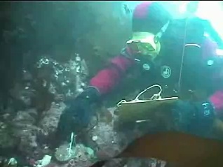
 In May of 2000, he returned to Race Rocks for a dive with Garry and Hana and an interview with Stephanie Paine and Director Julia Nunes for the Discovery Channel. In this video he demonstrates the measurement technique he used in his research.

Wallace, Scott, S. 1999, Evaluating the Effects of Three Forms of Marine Reserve on Northern Abalone Populations in British Columbia, Canada.

Conservation Biology, Vol 13 No 4, August, 1999, pages 882-887.

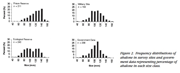
ABSTRACT: :Marine reserves have been suggested as tools for assisting the management of fisheries by protecting vulnerable marine species from overexploitation. Although there is a theoretical basis for believing that marine reserves may serve as management tools, there are few marine reserves in the world in which to test their effectiveness. My research evaluated three forms of marine reserve on the south coast of Vancouver Island, British Columbia, Canada. I used northern abalone (Haliotis kamtschatkana), a severely depleted shellfish in this region, as an indicator of the effectiveness of the reserves. Abalone populations in eight sites receiving different degrees of spatial protection were counted and measured in situ during the spring of 1996 and 1997. In all sites with enforced harvest closures, populations of abalone were greater, and one site with nearly 40 years of protection had on average much larger (older) abalone. Reproductive output, as a function of abundance and size, was also greater in the enforced reserve areas. Larval dispersal from reserves, and hence the benefit to exploited areas, was not formally surveyed. Nevertheless, the results of my study, combined with knowledge of present abalone populations, life history, and regional hydrodynamics, suggest that establishment of reserves is justified in the absence of perfect knowledge of larval dispersal.

This video was taken by Garry Fletcher of Scott as he was involved in measuring abalone at Race Rocks:

Articles published by Scott Wallace: 

Wallace, Scott, S. 1999, Evaluating the Effects of Three Forms of Marine Reserve on Northern Abalone Populations in British Columbia, Canada. Conservation Biology, Vol 13 No 4, August, 1999, pages 882-887.


Out of Sight, Out of Mind, and Almost out of Time:

Out of sight, almost out of time–mpa

Videos of First Nations Elders at Race Rocks

On May 2, 2000, we were privileged to take several members of local First Nations to Race Rocks. The late Earl Claxton, councillor of the Tsawout First Nations and his grandson were among those attending. Joe Bartleman, councillor of the Tsartlip First Nations also helped us to visualize the importance of marine animals in the diet of the people.

They talked with us about the past and present role of coastal ecosystems in the lives of the Salish people. These people always have been an integral part of ecosystems such as this one at Race Rocks. These video clips convey some of the stories that Earl and Joe had to tell about their people and their interactions with marine resources.
http://www.racerocks.com/racerock/archivefirstnations.htm