This gallery contains 2 photos.
Description: This plant is dark olive brown to black in colour, blade-like with a broad flat unbranched lamina up to 90 cm. long and 40 cm. wide at the end of a stout stipe up to 40 cm. long. … Continue reading
This gallery contains 2 photos.
Description: This plant is dark olive brown to black in colour, blade-like with a broad flat unbranched lamina up to 90 cm. long and 40 cm. wide at the end of a stout stipe up to 40 cm. long. … Continue reading
Alaria nana
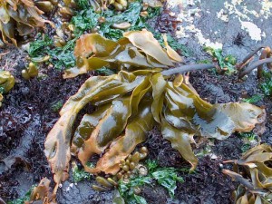
Alaria nana dessiccating at low tide
Classification:
Empire Eukaryota
Kingdom Chromista
Phylum Ochrophyta
Class Phaeophyceae
Order Laminariales
Family Alariaceae
Genus Alaria
Species nana
Description: The plant is olive brown to yellowish-brown in colour with a conspicuous blade (eroded at maturity), stipe, and holdfast. The holdfast is made up of short, firm root-like structures and is 3-7 cm. long, 5-8 mm. in diameter, merging into a slightly compressed rachis 2-4 cm. long. The rachis in turn merges into the blade, which is linear, tapering gradually to the apex and abruptly to the rachis; the blade is 40-60 cm. long and 3-8 cm. wide with a conspicuous, solid percurrent midrib 4-6 mm. wide.
Habitat: On rocks in the middle and upper intertidal zones in exposed areas.. This species grows at or around zero tide level at Race Rocks. WHen battered by waves and swell it often gets a tattered appearance.
Pacific Coast Distribution: Alaska to California. –Robert Scagel, 1972
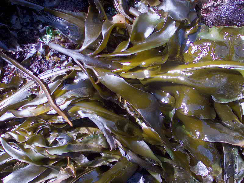
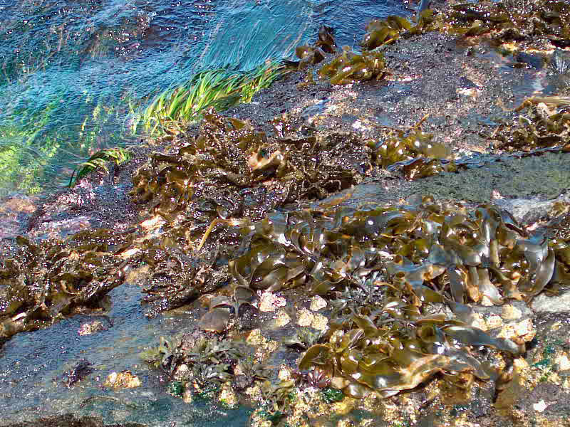
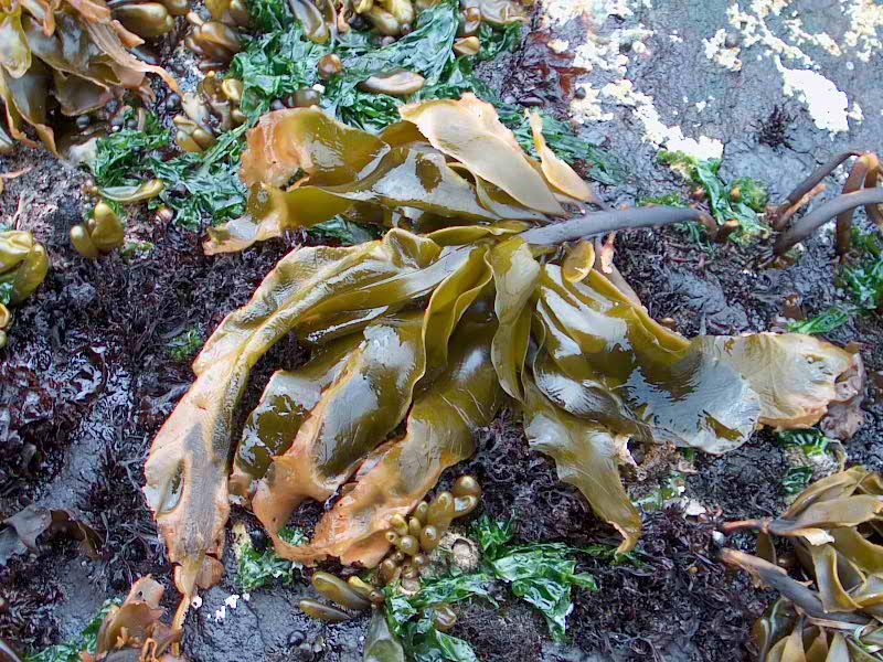
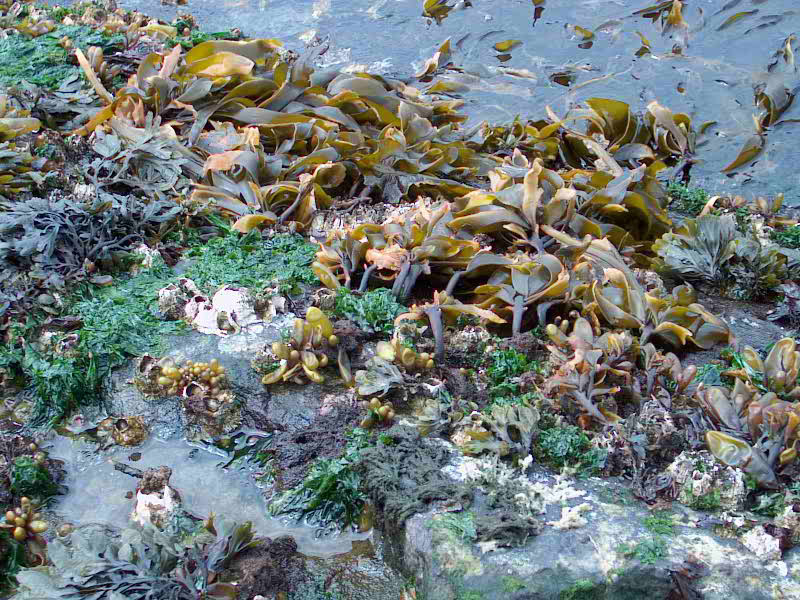
Table of Contents
ExecutiveSummary ……………………………………………..3 Protecting Our Marine Environment. . . . . . . . . . . . . . . . . . . . . . . . . . . . . . . . . . . . . . . . . . 4 A Time for Action . . . . . . . . . . . . . . . . . . . . . . . . . . . . . . . . . . . . . . . . . . . . . . . . . . . . . . . 6 BuildingaNetwork–AnInnovativeApproach ……………………………7 BenefitsofaMarineProtectedAreasNetwork ……………………………8 International Agreements and Commitments. . . . . . . . . . . . . . . . . . . . . . . . . . . . . . . . . . . 9 Linkages to Federal Initiatives . . . . . . . . . . . . . . . . . . . . . . . . . . . . . . . . . . . . . . . . . . . . . 10 Guiding Principles for Implementation . . . . . . . . . . . . . . . . . . . . . . . . . . . . . . . . . . . . . . . 10 The Strategic Framework . . . . . . . . . . . . . . . . . . . . . . . . . . . . . . . . . . . . . . . . . . . . . . . . 12
Appendix 1 – Federal Tools for Establishing and Managing
Marine Protected Areas . . . . . . . . . . . . . . . . . . . . . . . . . . . . . . . . . . . . . . . . . . . . . . 14
Appendix 2 – Roles and Responsibilities of Other Government
Departments in Marine Protected Areas (MPA) Establishment and Management. . . . 17
Appendix 3 – The Federal Approach to Building a Network
of Marine Protected Areas . . . . . . . . . . . . . . . . . . . . . . . . . . . . . . . . . . . . . . . . . . . . 18
See the Full PDF :2005canadasmarineproareastrategy
|
Executive Summary Around the world, marine protected areas are increasingly being endorsed as a valuable conserva- tion and protection tool. The benefits of a network of marine protected areas are numerous, diverse and include ecological, social, economic and cultural elements. The drive for a Federal Marine Protected Areas Strategy ensued from the need for a coopera- tive and collaborative approach to the development of a network of federal marine protected areas in Canada as a means to help address the declining health of our oceans. In 1997, the Oceans Act pro- vided Fisheries and Oceans Canada with a leading and coordinating role in this endeavor. The intent of this Strategy is to clarify the roles and responsibilities of federal departments and agencies with marine protected area mandates, namely Fisheries and Oceans Canada, Environment Canada In support of this goal, this Strategy will aim to fulfill its objectives to: • establish a more systematic approach to marine protected area planning and establishment; • enhance collaboration for management and monitoring of marine protected areas; • increase awareness, understanding and participa- tion of Canadians in the marine protected area network; and • link Canada’s network of marine protected areas to continental and global networks. These objectives, and the Strategy’s supporting activities, are a shared responsibility of Fisheries and Oceans Canada, Environment Canada and the Parks Canada Agency. Together, the departments and agencies will work towards meeting these objectives. To ensure that progress on the |
|
and the Parks Canada Agency, and to describe how federal marine protected area programs can collectively be used to create a cohesive and com- plementary network of marine protected areas. The establishment of a network of marine protected areas, established and managed within an integrated oceans management framework, that contributes to the health of Canada’s oceans and marine environments. In support of this goal, this Strategy will aim to fulfill its objectives to: • establish a more systematic approach to marine protected area planning and establishment; • enhance collaboration for management and monitoring of marine protected areas; • increase awareness, understanding and participa- tion of Canadians in the marine protected area network; and • link Canada’s network of marine protected areas to continental and global networks. These objectives, and the Strategy’s supporting activities, are a shared responsibility of Fisheries and Oceans Canada, Environment Canada and the Parks Canada Agency. Together, the departments and agencies will work towards meeting these objectives. To ensure that progress on the fied as candidate sites. In addition, the Strategy outlines how collective planning efforts will be undertaken to identify a suite of sites that may be added to the network in the future. See the FULL PDF: |
A Bold Initiative: racerocks.com utilizes 21st century technology to maximum advantage to create a dynamic educational web experience utilizing the extraordinary marine eco-system at Race Rocks, Canada’s most southerly point in the Pacific.
Real time streaming video webcasts digital images of marine life from above the sea at Race Rocks and below the ocean when divers are on hand to do the live mobile webcasts. In addition, a complete environmental scan will be continually transmitted from the site using an array of data sensors in five ecosystems of the area.
The knowledge of the First Nations is being explored and explained as the Salish people share generations of experience in living in harmony with the abundance that once dominated this region and is now threatened.
Creative educators are developing internet-based curriculum to stimulate students and teachers to engage fully in the racerocks.com educational program. Researchers will share their studies and discoveries as we gain a new and deeper understanding of the ecosystem
The Place
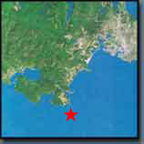 For centuries, deep ocean currents and the great rivers of the Georgia Basin have converged in the Strait of Juan de Fuca between southern Vancouver Island and Washington State. Race Rocks reveals itself as nine rocky outcrops thrust from the ocean floor in the middle of the strait.
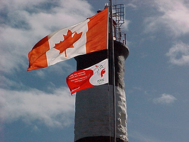
For generations the people of the Salish Nation prospered in this region at the entrance to the Salish Sea. The extraordinary richness of this diverse ecosystem represented by Race Rocks is valued today as it was then. Race Rocks has been an ecological reserve since 1980 and is becoming Canada’s first internationally recognized Marine Protected Area.
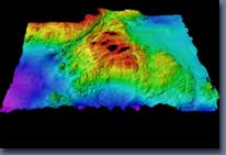 The small, rocky outcrops are home to seals, sea lions, elephant seals and birds, as well as the buildings and equipment of the Race Rocks Lighthouse. These outcrops are literally the tip of the ecosystem New leading-edge bathymetry reveals Race Rocks as a giant underwater mountain. The diversity of marine life is breathtaking and still not fully explored. The teachings of Salish elders merge with more recent science to explain the mysteries of nature at Race Rocks.
The Technology
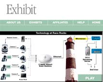
Recent developments have made a complex real time streaming video site possible. Presently three and potentially up to seven digital cameras and an array of data sensors above and below the ocean at Race Rocks will collect information. The signal is compressed and transmitted by broad band radio from the top of the Race Rocks light tower direct to nearby Pearson College. From Pearson College, through high speed fiber links to the racerocks.com server, and then on to the AKAMAI network, the video and data will be available throughout the internet. Two-way interactive capability is being incorporated into the design to allow for specific educational programming.
The Partners
 Lester B. Pearson College– is one of ten United World Colleges located around the world. Two hundred students from over 80 countries study the International Baccalaureate curriculum during their two years at Pearson College. Garry Fletcher, a faculty member teaching Environmental Systems and Biology at Pearson College, is the educational director of racerocks.com. Garry and his students will guide the educational content of the site. Pearson College operates the former Race Rocks light station facilities as a education centre under an agreement with BC Parks. Pearson College is the lead proponent and partner directing the racerocks.com project.
![]()
LGS Group Inc. – is one of Canada’s largest full service IT consulting firm with 2100 employees in 20 offices in Canada, Europe and the US. LGS is donating the time and resources to provide project management and web design services in the creation of racerocks.com. Along with their ability to capitalize on emerging Internet technologies to promote the project, LGS brings essential knowledge, skills, and expertise.
![]() Telus– a leading Canadian telecommunications company, is providing the bandwidth and server capability to host racerocks.com. Skilled technical staff at Telus have assisted in the development and implementation of the project assuring high-speed delivery to the Internet and accessibility to a large audience. Telus is donating this component to racerocks.com.
Telus– a leading Canadian telecommunications company, is providing the bandwidth and server capability to host racerocks.com. Skilled technical staff at Telus have assisted in the development and implementation of the project assuring high-speed delivery to the Internet and accessibility to a large audience. Telus is donating this component to racerocks.com.
Vancouver Aquarium Marine Science Centre-a leading organization in marine research and public education on the West Coast of Canada. The Marine Science Centre has committed a significant contribution of funds and expertise to the project. In return it will gain a new window for aquarium visitors into an ecologically sensitive marine world at the South tip of Vancouver Island. The most recent contribution is a hydrophone which will be installed subtidally at Race Rocks.
Apple Computers (Canada)– The Computers that we use for the live video webcasts from Race Rocks are all made by APPLE COMPUTERS. In July of 2000, Apple Canada became a partner in the Millennium Partnership program with the donation of a Macintosh PowerBook G3. 500 MHz. It followed up with further support in April of 2001 with the donation of a G4 500 MHz portable computer. These new high speed computers have been essential in broadcasting the manually operated live programs from the islands.They have been a most valuable addition for our live video webcasting programs.
Apple and the Apple Learning Interchange:
The quicklime live video streams were hosted by the Apple Learning interchange over the Akamai Internet distribution network. In April of 2001, a set of three airport cards was provided by ALI in order to make all the cameras webcasting wirelessly from the island. Race Rocks support pages, learning activities, discussion forums, and scheduled chats.
Seapoint Sensors Inc. of Kingston New Hampshire has joined as a partner providing a turbidity meter for measuring turbidity or suspended solids and a Chlorophyll fluorometer for measuring chlorophyll a . Both are representative of a fine line of high performance oceanographic sensors. They are installed sub-tidaly in 8 meters of water off the docks on the North Side of Race Rocks .
![]() CompuSmart of Victoria , B.C. has joined as a partner in providing the majority of the funds for the purchase of a new computer for the Database which is being produced to handle the Phase 2 Environmental Data Sensors for Race Rocks.
CompuSmart of Victoria , B.C. has joined as a partner in providing the majority of the funds for the purchase of a new computer for the Database which is being produced to handle the Phase 2 Environmental Data Sensors for Race Rocks.
![]() Sorenson Media provided software to assist in the production of the live streaming video and the improvement of the archived video on the website.
Sorenson Media provided software to assist in the production of the live streaming video and the improvement of the archived video on the website.
 FRIENDS of ECOLOGICAL RESERVES-The “Friends” have been long time supporters of Race Rocks. They have given financial help for the purchase in 2000 of a camera for the project and in 2001, a SONY wireless microphone.
![]() SONY of Canada Ltd.
SONY of Canada Ltd.
joined as a partner in April of 2001, with the donation of a SONY Digital Video camera. This camera joins the three other SONY cameras that are used to provide the live streaming video from Race Rocks.
 Government Agencies-racerocks.com has received assistance from the Department of Fisheries and Oceans in many aspects of the project development. BC Parks has provided the use of buildings and facilities at Race Rocks. Both levels of government are working cooperatively with local First Nations groups as well as other community groups to create the Race Rocks Marine Protected Area.
Millennium Partnership Fund– racerocks.com would not have been possible without major funding from the Canadian Millennium Partnership Fund of the Government of Canada. We are very grateful to the Federal Government and all those who assisted us in our application.
Graduate Students We are particularly fortunate to benefit from the services and support of a number of alumni of Lester B. Pearson College who have donated their time or have given direct financial assistance to racerocks.com
Ken Dunham ( PC year 9) has designed and implemented the advanced network at Pearson College, and recently
extended these facilities across the water to Race Rocks.
Giovanni Rosso (PC year 24) has provided the money for a digital camera which we use to document the project.
Jochen Kumm (PC year 10) has provided a computer for the Ecological Overview database and is assisting with the development of the Environmental Database for racerocks.com
Affiliated Organizations
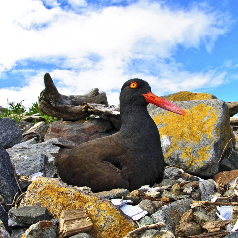
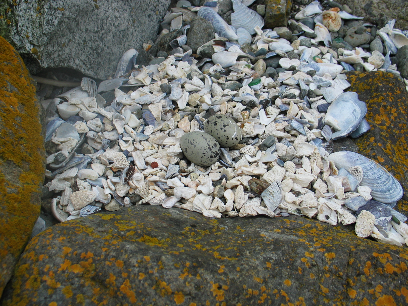
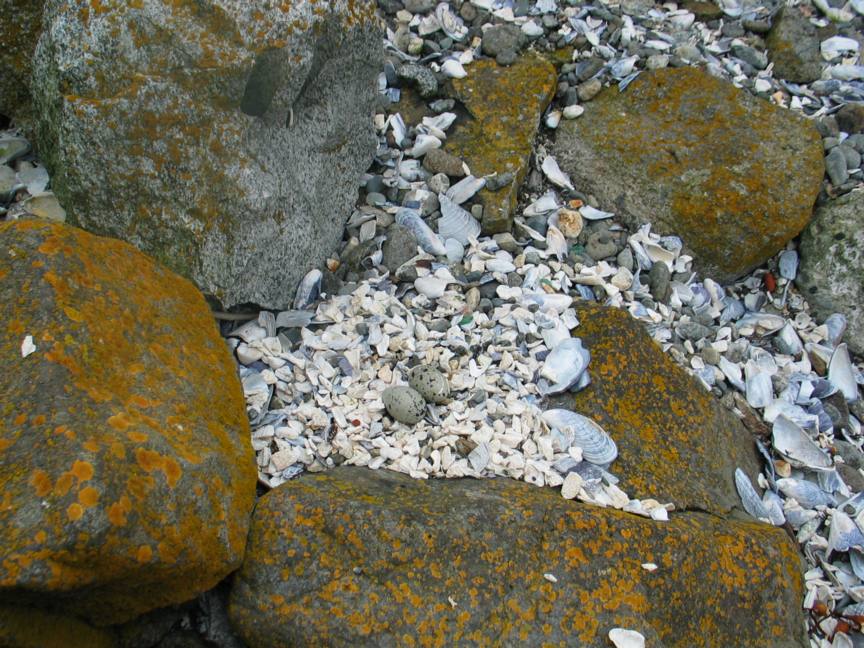
These pictures were taken in June 2005 of a nest in the surge channel off the engine room. The images show how well the eggs are camouflaged.
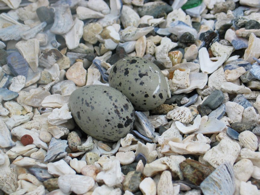
Black Oystercatcher nest photo by Garry Fletcher
CLICK ON IMAGES FOR LARGE SIZED CHARTS
 This file is extracted from a report of the analysis of the data by Rick Birch of ASL from the ADCP Deployment at Site 1.
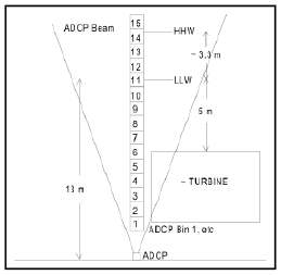 Figure 1 Bin Locations:
The mooring was deployed on the bottom on may 30 and recovered on June 15, 2005. The ADCP collected current profile data in 1m bins starting from 2.5 metres off the bottom (bin 1).Times were recorded in PDT and directions in degrees magnetic. Directions were converted to degrees true during processing by adding 19 degrees. Water Depth: 13 m (LLW) Location: 48 17,955’N 123 31, 937′ W
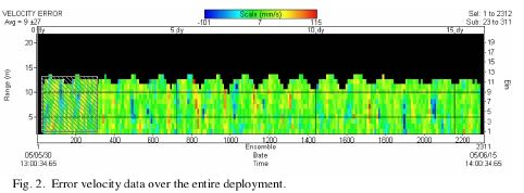
Data Quality:
One of the primary indicators of ADCP velocity data quality is the error velocity. This is the difference in computed vertical velocities using different combinations of 3 beams. Error velocities over the deployment were generally less than 5cm/s and never exceeded 12 cm/s (Figure 2).This is generally considered acceptable for such a deployment.
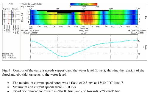
Characteristics of the measured currents:
Most of the current is due to tides. Maximum tidal ranges reach 3.3 m during the larger ‘spring’ tides. Tides are mixed, mainly diurnal with one main low and one main high each day. Peak ebb currents occur ~2 hours before the main low tide, and peak flood currents occur~ 4-5 hours after the main low tide (Fig.3). Flood tide currents are generally stronger than the ebb.
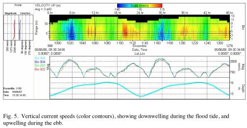
Upwelling/Downwelling:
As at site 2, there was upwelling on the ebb flow and downwelling on the flood. Maximum vertical velocities reached about 11 and 15 cm/s respectively (Fig 5)
This probably relates to the shallows just West of the site.
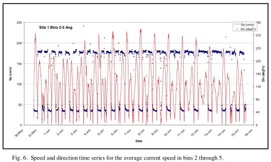
Bin 2-5 Average Current
The current velocity data from bins 2-5 were selected as representative of the flow through the turbine and were averaged.
Figure 6 is a plot of the averaged current speeds over the entire record. The average current speeds range up to about 2.3 m/s on the floods , and 1.75 on the ebbs.
Ed.note: Due to these low current levels, site 1 had to be abandoned as a candidate for the tidal current generator location.
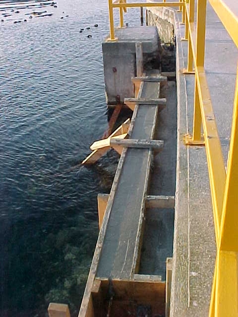
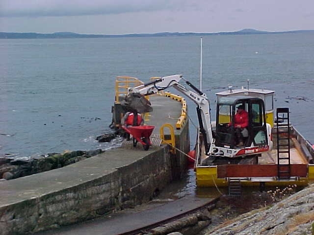
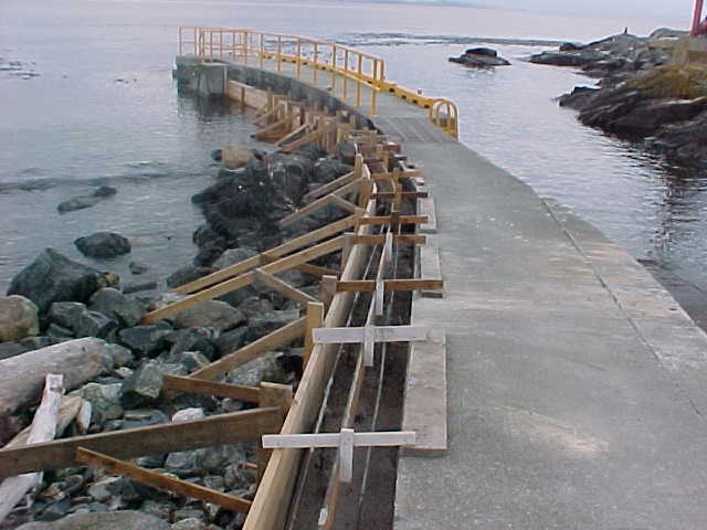
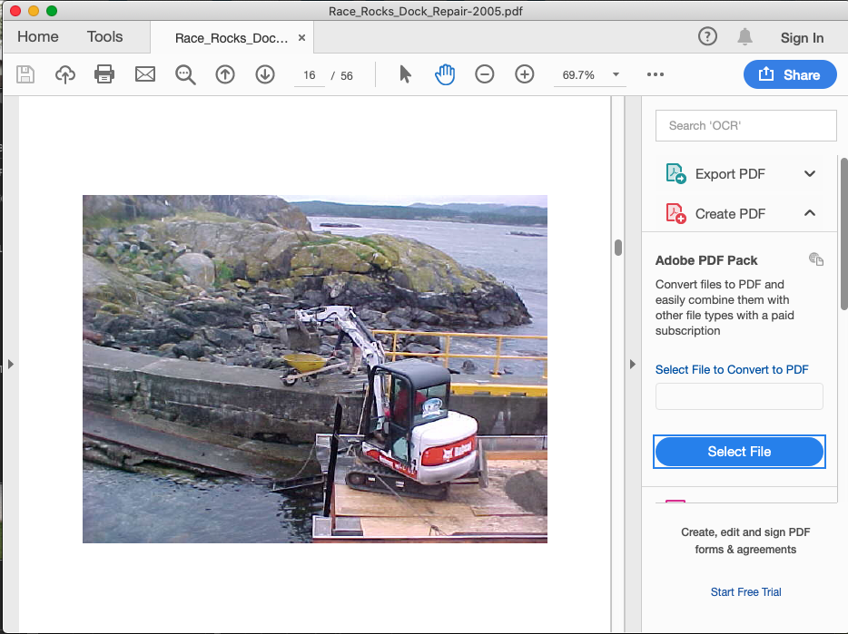
Mike and Carol Slater who were Ecoguardians of Race Rocks at the time took this set of images on the process that was used to repair the Jetty at Race Rocks. There had been serious undercutting and erosion on the West side of the docks so it had to be fixed to avoid total collapse. There are 56 images of the work in this pdf: