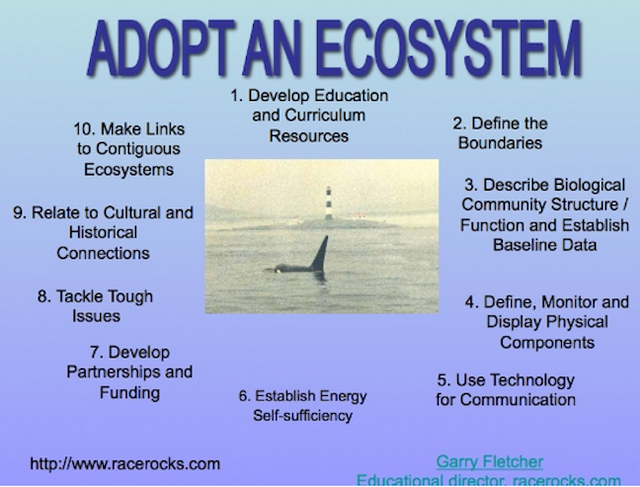
By involving individuals in the documentation and monitoring of their adopted ecosystem, a sense of “ownership” of one’s ecosystems and responsibility for their stewardship is experienced. In addition participants are encouraged to use technology to assist in the accumulation of valuable long-term ecological information which can serve as baselines for environmental impact decisions in the area, and as a valuable baseline on the area’s biodiversity.
OBJECTIVES: (The teacher and class may decide on setting their goals for this project, using only a limited number of the suggested activities.) After doing this assignment, students will be able to:
a) Design a plan and procedure for the creation of a local : “Adopted Ecosystem”
b) Use field methods involving quantification to document the chosen ecosystem with a baseline inventory.
c) Use a Spreadsheet program for the analysis and recording of locally collected data.
d) Set up a weather station for collection of weather data.
e) Construct a species list and/or taxonomy of the local organisms in the “Adopted Ecosystem”.
f. iNaturalist contributions Recently I opened an account on iNaturalist.com . I have been able to add many pictures of species taken around the Metchosin coast, as well as other locations. https://www.inaturalist.org/observations/garryf
It is a great idea to contribute to iNaturalist so by opening a free account on iNaturalist.com it is a good way to do establish a baseline for organisms in your ecosystem and get professional assistance from experts for identification of species. for instance for the biodiversity project the following entries are recorded by various individuals, https://www.inaturalist.org/projects/metchosin-biodiversity
f) Setup a website dedicated to the collection of resources relating to your locally adopted ecosystem.
g) Outline the Ecosystem Services and the value of the Natural Capital of your adopted Ecosystem.
PROCEDURE:. Identify the area and describe the ecological features that make the area unique, important or just representative of other surrounding ecosystems. Also indicate what your group intends to do with it.
2. You may indicate time lines for your goals, and even designate responsibilities to different group members in order to help you plan your strategy.
3. Establish a good “baseline inventory ” of what is there presently. Many ecological techniques are available to quantify organisms and their distribution. You may use our Transect Files as an example.
4. Establish a class project to provide a taxonomy of the species of your local ecosystem.
5. Include dated maps, databases, taxonomic inventories, checklists, photographs, videos or drawings to document your site. Open a project on iNaturalist.com that enables you to enter photos of species and have experts help in making identifications
6. Begin monitoring the site for aspects of its structure and function. For structure: what living things are there, how they are distributed, what relationships or biotic associations exist. Also, the structure includes physical factors such as temperature, salinity, etc. –start gathering long term data, enter it into a database (such as excel), and save it to the internet site so that others can download and manipulate the data.
7.Download Google Earth and make a 3 dimensional image of the area with your ecosystem.
8. Search for historical and other recent maps or charts of your area. Include these as part of the information recorded.
9. If you have access to your own internet site, assemble the information on the site, let us know its location and we will provide a link to your site from racerocks.ca.
10. Establish a Project to list and value the Ecosystem Services and Natural Capital of your ecosystem. In recent years, we have started to acknowledge that “ecosystem services ” are something to which we must start paying attention as to fail to do so leads to a decline in quality of life:
This file explores that idea further and invites you to contribute to a new project : Defining the Ecosystem Services of Race Rocks. By looking at the model of such services developed for Race Rocks, you might also get an idea how you could choose a part of your own local ecosystem and do a similar analysis.
11. In the fall of 2005 we installed a Davis Weather Instrument at Race Rocks for real time monitoring of a number of meteorological events.
From this environmental data index page, you can see how we are developing pages for each environmental abiotic factor and interpreting how that factor is important in the ecosystems of Race Rocks. Many schools already have weather stations installed. Here are some examples from the Victoria area:
Send inquiries to: Garry Fletcher

