https://www.youtube.com/watch?v=Pd-94YlgHVg
Author Archives: Garry Fletcher
The 13 Moons of the Wsanec
THE 13 MOONS of the WSANEC (Saanich people)- Now a JASON PROJECT Curriculum Lesson:Teacher Instructions
To order books contact :
Saanich Indian School Board,
7449 W.Saanich Road,
P.O. Box 368, Brentwood Bay, B.C.
V0S 1A0
Telephone 250-652-2313
Note – accurate spelling of the names is available in the calendar,(top left below) These images have been scanned with permission from the booklet ” The Saanich Year” Author Earle Claxton, Author/Illustrator: John Elliott. Published by the Saanich School Board #63 1993 ISBN 1-55036-366-2
-
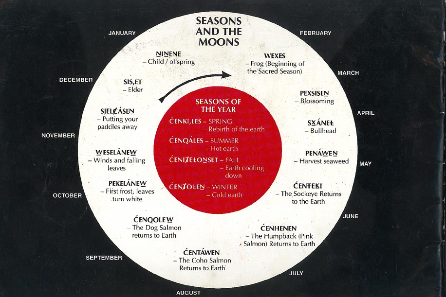
- The Thirteen Moons Calendar
-

- NINENE-Moon of the Child (Jan.)
-

- WEXWS-Moon of the Frog (Mid Feb. to Mid March)
-

- PEKSISEN-The Moon of the Opening hands the blossoming out Moon (Mid-March to Mid April)
-

- SXANEL- The Bullhead Moon (April-May)
-

- PENAWEN-Moon of the Camas Harvest (May)
-

- CENTEKI- The Sockeye moon (May-June)
-
- CENHENEN-Humpback salmon return to earth (June-July)
-

- CENTAWEN- The Coho Salmon return to earth (August)
-

- CENQOLEW-The Dog Salmon return to Earth ( Sept)
-

- PEKELANEW-Moon that turns the leaves white(Oct.)
-

- WESELANEW Moon of the shaker leaves -(Oct.-Nov.)
-

- SJELCASEN- The Moon of putting your paddle away in the bush (Nov.-Dec.)
-

- SIS,ET- The ELder Moon (Dec)

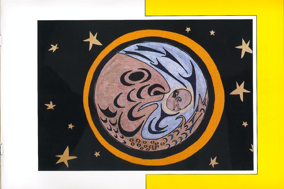
NINENE-Moon of the Child (Jan.)
NINENE – MOON OF THE CHILD (Mid December to Mid January)
The face of the young man represents youth, a new beginning, the rebirth of the animal world, and the new edible shoots. This is the Saanich New Year. The moon’s yellow hair is the returning light to the world.
CONNECTIONS AND BACKGROUND INFORMATION
The Winter Solstice (December 20/21) is the point at which the sun is farthest from the Equator, thus it is the darkest day of the year, and at this “turning point” the days will become longer. As with the Summer Solstice, the shortest day of the year holds great importance in many cultures.
WEATHER
This is the time that the Northern Hemisphere starts to move closer to the Sun once again. All things begin to warm up; everything in nature is being reborn. Although it is cold and there are Winter rains, there are some good days and this is the first sign that a new year has begun.
ECONOMIC ACTIVITIES
Some of the twine that had been made from nettles was now woven for reef net fishing. Each family group had a responsibility to produce a certain amount of net or the fishery and these parts would later be assembled. Because there was no hunting or fishing going on, people relied mainly on the fish and game that had been stored for the Winter. For those who would risk the rough seas, there was halibut fishing as the fish returned to their spawning grounds. This was also the season when fawns were born, so the new moon signaled the time to stop deer hunting.
CULTURAL ACTIVITIES
The instruction of the children through telling of tales helped to pass the long Winter nights. The longhouse ceremonial dances continued.
THINGS TO THINK ABOUT
Why do so many cultures celebrate New Year’s at this time of year?
What are New Year’s celebrations like in other cultures?
Are other culture’s New Year’s celebrations in and around the winter solstice?
If you were to develop your own New Year’s celebration, how would you organize it?
=================================================

WEXWS-Moon of the Frog (Mid Feb. to Mid March)
WEXES – MOON OF THE FROG (Mid February to Mid March)
The frog on the face of the moon represents DOLUANW – the Keeper of the Sacred Season. It is time to gather foods and medicine. The Saanich People place cedar boughs in the water close to the shore, so that the herring will lay roe on them.
CONNECTIONS AND BACKGROUND INFORMATION
February derives its name from the Latin word ‘februarius’ which means to purify. The Saanich People, like the Romans, designated this month to sacredness and purification. March derives its name from Mars, the Roman god of War. The Anglo Saxons called it the ‘Hlyd Monath – the loud and stormy month’.
For the Saanich Peoples, this moon in particular was significant because the frog acts as a witness and a messenger to them. The frog announced the Sacred Season of Plenty. Because the frog was honoured as the Keeper of the Sacred Season, it was often presented on totem poles and in artwork to show that an important event had occurred.
During this moon, the wonder of nature repeats an amazing process: Mother Earth warms up and the hibernating frog wakes from its winter sleep, announcing the coming of spring.
WEATHER
As the Northern Hemisphere moves closer to the Sun, the more the Earth warms. Rains diminish and more sunshine is evident.
ECONOMIC ACTIVITIES
This moon was especially welcomed because it signalled that the ocean had become safer to travel on and it was time to put the canoes back into the water. Herring and herring roe, a source of food, were collected by placing cedar branches along the shore for the herring to lay their eggs upon. Herring was also dried into a delicacy called QELEJ and stored for future use. The earliest runs of herring were into Fulford Harbour on Saltspring Island.
CULTURAL ACTIVITIES
The appearance of the frog was a sign to end the activities of Winter ceremonial dances and move outdoors to prepare for the season when the Salmon people would return.
THINGS TO THINK ABOUT
- Who or what do you honour in your life?
- What signals does nature give us to start or end things?
- In what ways do you and your family prepare for spring?
==============================================

PEKSISEN-The Moon of the Opening hands the blossoming out Moon (Mid-March to Mid April)
PEXSISEN – THE MOON OF OPENING HANDS THE BLOSSOMING OUT MOON (Mid March to Mid April)
All the plants and trees are opening up their hands again and the moon meets their welcome. All of nature is blooming. At this time the Brant Geese are dried. The Earth renews its strength.
CONNECTIONS AND BACKGROUND INFORMATION
April derives it name from the Latin word “Aprilis”, the Roman goddess Aphrodite and the Greek word “to open”. It should be noted that most countries in the Northern Hemisphere celebrate the arrival of Spring. At this time of year, the trees open their leaves in welcome, just as the Saanich People open their hands to show thanks.
WEATHER
There is less rain than previous months and it is warmer. This helps dry out the land and enables the drying and preservation of food.
ECONOMIC ACTIVITIES
During this time, the Saanich Peoples hunted and dried XELXELJ (Brant Geese) for future use. Float nets were placed where the XELXELJ would feed along the tide line to capture the geese. Clams, Oysters and mussels were at their best that this time of year, too.
Cedar trees were fallen at this time of year to make boats, among other things. The warmer weather also caused the tree sap to run up the trees, making it easier to strip the bark. The fallen trees were then left to cure and the bark was saved for weaving into mats and clothing.
Before the Saanich People started to raise sheep, they would use goat and dog hair for spinning yarn and knitting. Their primary wool source was a breed of dog that was small, white and woolly. The warmer weather caused the dogs to shed and their hair would be gathered for carding and later, knitting.
THINGS TO THINK ABOUT
- What animal hair or wool is used in other countries? (e.g. Llamas)
- What activities happen in Western culture’s Gregorian calendar that are similar to those in the First Nations?
===========================================

SXANEL- The Bullhead Moon (April-May)
SXÁNEL – BULLHEAD MOON (April – May)
This moon represents the visibility of SXÁNEL or what westerners call Orion’s Belt. The moon’s hair represents a strong wind that comes at this time and the swallows that arrive with the wind.
CONNECTIONS AND BACKGROUND INFORMATION
In this moon, the PIOTEL (a group of three starts in Orion’s belt called the Duck Hunters) appears on the horizon. During the SXÁNEL there are strong winds, the bullhead (a type of sculpin) appear on the shore and the swallows arrive.
WEATHER
This is the season where good weather is the norm. However, these days can bring sudden thunder and lightning storms.
ECONOMIC ACTIVITIES
People spent more time on and around the water. During the moon the Elder women knew how to take their baskets to the beach and gather bullheads from under the rocks. The women would pole sticks under the rocks and big bullheads would say “SKA”, which is their name. The bullhead was deemed a great delicacy.
This was also a great time for harvesting seaweed LEKES).
The halibut fishery ended because the halibut spawned during this moon. The grouse hatched and the larger/older grouse could easily be snared in the woods.
THINGS TO THINK ABOUT
- What are activities that you start participating in now that spring has arrived? Compare these to First Nations’ activities.
- What do you look forward to during this season?
- What is a delicacy or a delectable? What foods do you consider to be delicacies or delectable?
- What do you eat that comes from the sea?
===============================================
 PENAWEN-Moon of the Camas Harvest (May) PENAWEN – MOON OF THE CAMAS HARVEST (May) This moon is the moon of the camas harvest. It is time to dig KLO,EL (camas). The earth is warming. The camas bulb illustration is shown on the cheek of the moon and in the palm of his hand. The blue plant with the bulb underneath the ground is the whole camas plant. CONNECTIONS AND BACKGROUND INFORMATION May derives its name from Majores, the Roman goddess of Spring. This is also the ‘month of Mary’ for those of the Roman Catholic Faith. During the PEN’AWEN moon the Saanich Peoples travelled to family locations to harvest camas bulbs (KLO,EL), which were the source of starch in their diet. This was a cherished time for the people of Saanich – it marked the time when they could begin travelling through their territory again. WEATHER Days are evenings are warm and rain is less frequent. ECONOMIC ACTIVITIES Saanich families had traditional territorial grounds (land and water), which were used at various times of the year. Most families left their Winter villages for Spring camps. Visits to the camas plots served two purposes: (1) to harvest the blue camas bulb; and (2) to gather the fresh gull eggs found in the camas fields. White camas is poisonous and was not harvested. In this season both XIWE (purple sea urchins) and SQITI (green sea urchins) were collected and eaten as well. THINGS TO THINK ABOUT
================================================
 CENTEKI- The Sockeye moon (May-June) CENTEKI – THE SOCKEYE MOON (June) This moon is the same colour as the pale grey sockeye salmon. The sockeye returns during this moon. The Salish art design represents the tide running swiftly through the reef net which is tied to the two canoes (SXELSCET). CONNECTIONS AND BACKGROUND INFORMATION There are two western legends to how this moon was named. First, is that it derives its name from the Roman goddess of woman and marriage (Juno) and second, that the name is derived from Juniores, the name for the lower branch of the Roman senate and/or connected with the Roman consulate, Junius Brutus. It is interesting to note that June is in mnay cultures, the wedding month, and there are festivals of flowers around the world. The Saanich Peoples history says that the people were once very poor. However, the Salmon people took pity on them and saved them by showing them how to fish and honour the salmon. At the beginning of the CENTEKI moon, a special salmon ceremony was performed before the net anchors were dropped at the ancestors hereditary family locations. The special ceremony started when the medicine man (SNAEM) paddled to the furthest point east and called on ancient relatives (the salmon) to let themselves be caught to feed the WSANEC people. His songs and prayers mentioned all of the family reef net locations that the salmon would pass through. Fishing continued throughout the four salmon months. WEATHER Warm summer breezes and dry weather were most evident during the CENTEKI season. The WEWELES (Swansen’s Thrush) – the ripener of the summer berries, arrived. His song put colour into the berries. The DILEK (wild strawberries) and ELI,LE (salmon berries) began to ripen. ECONOMIC ACTIVITIES Trading catches from the salmon runs began. As the Saanich Peoples were the first to catch salmon in the Straits because other tribes were waiting for river runs, they were able to catch a higher quality of bright salmon, thus giving them a full month of trading advantage. CULTURAL ACTIVITIES The Saanich People paid homage to the salmon with a very special song and ceremony to honour the salmon and show respect to its new generation. After the first sockeye salmon (known as the S,HIWEK leader) was caught, all fishing would cease and the ceremony of prayer and feast would begin. As part of the salmon ceremony, children would walk with a limp to show humbleness and to look pitiful in the eyes of the honoured salmon. They would also carry the hook nose salmon as one would carry a baby. Only the children would eat this salmon. Later, the adults could then feast on the Sockeye. THINGS TO THINK ABOUT
|
=============================================

CENHENEN-Humpback salmon return to earth (June-July)
CENHENEN – HUMPBACK SALMON RETURN TO EARTH (July)
The Humpback salmon return to the earth during this moon. The illustration is half salmon and half human. The darts show the tidal waters that are used to catch salmon. The child carrying the salmon represents the first salmon ceremony in honour of the salmon. Saanich People humble themselves to the salmon.
CONNECTIONS AND BACKGROUND INFORMATION
July derives its name from Julius Caesar, who was born during this month. This month is important in Spain (bull fights) and Japan (animal festivals). Actual jousting and other medieval-type activities take place for three days during the Japanese Horse festival.
This moon marks the arrival of the Humpback salmon.
WEATHER
This was the dry weather season, drier than the interior of Canada. Although it was a good season for drying Salmon (SDÁL), the grass and forest was parched and everyone guarded against starting grass and bush fires.
ECONOMIC ACTIVITIES
This was the season for Humpback salmon fishing. Fishing caused First Nations peoples to extend catchment areas to areas as far away as Tsawassen and Point Roberts where they maintained shore camps.
CULTURAL ACTIVITIES
The success of the salmon fishery caused those most fortunate to celebrate and share their success with others. This season was especially marked by large family, village and neighbouring village gatherings, including gatherings where traditional sports were held. This was a time to reaffirm family ties and history and hold other gatherings. These included STÁNEK (memorial potlatches), namings (giving of a name ceremonies), weddings and societal ceremonies (e.g. blessings).
Potlaches enabled the more fortunate to share and distribute goods with those less fortunate than themselves. To become wealthy was honourable and to share one’s wealth with one’s neighbours was a traditional expression of Saanich values.
THINGS TO THINK ABOUT
- What sports events are held by first Nations People are similar or different to those found in other communities and countries?
- What does being wealthy mean to you?
- In what ways can an individual, community or country be wealthy?
- Does wealth always have a connection with careers and money?
- What is the difference between work and play?
- Can they be synonomous?
- What are the values of your family? How are values, beliefs and achievements celebrated?
==============================================

CENTAWEN- The Coho Salmon return to earth (August)
CENTÁWEN – THE COHO SALMON RETURN TO EARTH (August)
The Coho Salmon returns to the Earth. The illustration shows the face of the Coho and the human together. The face of the Coho/human is to remind the Saanich Peoples that the salmon were human at one time. The swift running tide picture illustrates where the salmon travel. The camp is the home away from permanent home for the Saanich Peoples.
CONNECTIONS AND BACKGROUND INFORMATION
August derives its name from the Roman Emperor Augustus Caesar. In most northern countries this is the time for summer holidays, fairs, fetes and festivals. The moon marks the arrival of the Coho Salmon.
WEATHER
The first rains begin and break the drought of the summer. Water flow in the streams, rivers and creeks increases. This enables the salmon that have gathered in the inlets, to begin their spawning journey.
ECONOMIC ACTIVITIES
This was a good moon for cod fishing. Traditionally the sea urchins were used as bait for Tommy Cod and the Tommy Cod was used as bait for the larger Ling Cod. Ling Cod could be lured to the surface with bait alone and speared since they were so anxious to protect their nests, that they would take a hook without the bait. As the weather cooled, the rains came and the forest was renewed once again. Deer Hunting began. This was also a good month to harvest the Hog Fennel (KEXMIN) which was used in a variety of First Nations medicines.
THINGS TO THINK ABOUT
- What are differences between Coho, Sockeye, Humpback and Dog Salmon?
- How can you tell if a fish is fresh or not?
- This is a time for harvesting plants for medicines. Can you think of any plants that produce medicines?
==========================================
 CENQOLEW-The Dog Salmon return to Earth ( Sept) CENQOLEW – THE DOG SALMON RETURN TO EARTH (September) The Dog Salmon return to the Earth Moon at this time. The colours are Dog Salmon (ochre red). The men are returning the bones of the salmon to the sea, with thanks, in the belief that the bones will come to life and replenish the salmon stocks. The man raises his oar to show honour and respect to our relative, the salmon, who helps us survive. CONNECTIONS AND BACKGROUND INFORMATION September derives its name from the Latin word ‘septem’, meaning seven. This was the seventh month in the Roman calendar when the year began in March. This moon marks the arrival of the Dog Salmon. WEATHER The rainy weather continues and the winds have become unpredicatable. The creeks and rivers rise enough for the Dog Salmon to spawn. ECONOMIC ACTIVITIES Hunting for deer and groups was still ongoing. This was also the best season and weather conditions for cod fishing. Dog Salmon were the last of the salmon runs to return and the Saanich Peoples carried out this fishery at Goldstream. Dog Salmon was easily dried or smoked and was the last of the preserves to be stored away. The Langford area was excellent for cranberries, blueberries and grouse hunting. CULTURAL ACTIVITIES If the salmon run was late, the SNAM (spiritual leader or priest) was brought in to hold a ceremony to call the salmon. The SNAM would also advise the family captains of the correct protocol to adopt so that they would not offend the Salmon Peoples and thus ensure that the salmon returned to the rivers. THINGS TO THINK ABOUT
|
=============================================

PEKELANEW-Moon that turns the leaves white(Oct.)
PEKELANEW – The Moon That Turns the Leaves White (October)
This is the moon of the turning white season (frost). This moon brings the first frost. The leaves lose their colours and turn pale. Deer hunting is the activity during this moon. The earth is cooling down and the people turn their efforts to hunting.
CONNECTIONS AND BACKGROUND INFORMATION
October derives its name from the Latin word ‘octo’ meaning eight. It was the eighth month of the Roman year. The moon marks the end of summer (snails) and the beginning of cooler weather.
WEATHER
The longer, cooler nights can lead to frost on the leaves and the ground in higher country.
ECONOMIC ACTIVITIES
The WSANEC people began splitting the cedar logs they had felled in the Spring. The completion of the canoes was Winter work. They would rough out their canoes in the forest making them easier to carry and move them to the villages.
Seals and Sea Lions were hunted in the San Juan Islands. Cod fishing tapered off toward the end of this moon and grouse hunting ceased. Preparations were made for the Fall hunt of the deer and elk. Deer were in their rutting season and easily fooled because they were not as cautious as normal.
THINGS TO THINK ABOUT
- What does ‘rut’ mean and why would deer be more easily fooled?
- What are various methods of hunting seals and sea lions?
- How is or was steam used to make canoes and bent wooden boxes?
===========================================

WESELANEW Moon of the shaker leaves -(Oct.-Nov.)
WESELÁNEW – MOON OF THE SHAKER LEAVES (November)
The leaves are ready to fall. The wind comes. Turbulence is felt in the waters and the skies. The earth is cooling down.
CONNECTIONS AND BACKGROUND INFORMATION
November derives its name from the Latin word ‘Novem’ meaning nine, and was the ninth moon in the Roman year. This marked the beginning of Winter. Traditionally, the Anglo Saxons did their slaughtering now (letting blood) because the cold weather was conducive to preserving the meat of the animal/bird. In the WESELÁNEW moon, fishing was undertaken mostly in the safety of local waters. This was the time when big winds come and changed the season to Winter.
WEATHER
The days became cooler and travelling in food gathering territory was limited. The winds that came with this moon were a signal to move to the winter village as the open sea became dangerous for movement in open boats.
ECONOMIC ACTIVITIES
Most foods were now in storage for the Winter and fishing was done only close to the village sites. The Saanich Peoples formed hunting parties and moved West into the mountains to hunt elk. Elk were only hunted after the first snowfall as it was easier to track an elk if it was wounded. This way no meat would be wasted.
CULTURAL ACTIVITIES
Winter fires were lit and this was the beginning of Winter gatherings.
THINGS TO THINK ABOUT
- What seasonal changes occur where you live?
- How does the direction of the wind affect climate?
- What are the effects of pollution and global warming on fish and wildlife?
============================================

SJELCASEN- The Moon of putting your paddle away in the bush (Nov.-Dec.)
SJELCASEN – THE MOON OF PUTTING YOUR PADDLE AWAY IN THE BUSH (November).
This moon is the season of strong winds. The weather is unpredictable, making it unsafe to travel. It is time to put the big sea canoes and paddles away. It is time to honour the paddle for carrying one safely all season long. Snow is possible at this time of year. The long house activities start.
CONNECTIONS AND BACKGROUND INFORMATION
November derives its name from the Latin word ‘novem’ meaning ‘nine’. It was the nineth month of the Roman year. With the coming of this moon, it was time for the people to thank their paddle for taking them to gather foods, see loved ones and guide them to special ceremonies.
WEATHER
Strong and sudden winds are now common on the open sea and it has become unsafe to travel. Squalls and heavy rains can appear suddenly and without warning. South-easterlies are SKANET and south-westerlies are SCES.
ECONOMIC ACTIVITIES
Food gathering takes less time. The winter night tides were low enough for clam digging. Winter clothing was needed. There was now more time to weave mats and capes and to knit wool into clothing. Some items that were stored for Winter included:
- Materials for making twine, rope, lines, cables, baskets and storage boxes
- Cedar inner bark (SLEWI), cooking utensils, and cooking baskets
- Weaving materials for making baby cradles etc.
- Tools and fishing gear either made new or repaired.
Red cedar logs felled earlier in the year were now split into planks which were used as portable roofing and building material (S,ILETEW).
Natural splitting of logs was accomplished by inserting round stones as wedges into the cracks of the drying logs. The Winter winds hastened the drying and splitting process.
CULTURAL ACTIVITIES
It was a time for storytelling and Winter ceremonies. People settled down for Winter and enjoyed the food they had gathered and stored earlier.
THINGS TO THINK ABOUT
- Why do we need to ‘rest’ or putting the paddle away?
- Nature ‘renews’ itself through hibernation. Trees lower their production of sap in the winter. What are other ways that nature rests?
- How is the importance of the cedar tree in the Saanich Peoples’ culture similar or difference to the importance of plants in other cultures? (For example, think about corn!).
- Why is it so important to learn about our roots and heritage? Reflect on your own heritage. What has been passed down to you in terms of language, ideas, wisdom, artefacts etc. what is precious in your family? How does this relate to the stories and traditions of the longhouse?
================================================

SIS,ET- The ELder Moon (Dec)
SIS,ET – THE ELDER MOON (December)
The Elder’s hair holds and shields the elderly people who share the teachings, the beliefs, the history and the culture with the children who are gathered in the warmth of the firelight.
CONNECTIONS AND BACKGROUND INFORMATION
This is the oldest of the moon family and means the elder. It is also the time when teaching occurs. In reality this is not the first month but the last in the yearly cycle of the moons. It is at this time of year when the earth is at its farthest point from the sun and the Winter Solstice occurs (December 20/21). As with the Summer Solstice, this day holds great importance in many cultures.
WEATHER
Days are short and storms and heavy rainfalls made sea travel unpredictable and unsafe. Therefore much more time was spent indoors. The sloughs in and around Saanich filled with water and provided a wintering place for visiting ducks and geese.
ECONOMIC ACTIVITIES
The Saanich people had abundant stored food and therefore had time to prepare for future harvests. Wood pitch was gathered for torches and fires. Torches were used to collect shellfish during the night tides, which were common at this time of year. Ducks and geese were netted or speared on the sloughs and in protected inlets. People only ventured into the protected inlets for ocean fishing. Nettles, gathered earlier in the year, were stripped and twisted into twine to make nets, ropes and cables. Roughed out canoes were brought into the longhouse to be finished.
CULTURAL ACTIVITIES
This is the most important time of the year for spiritual and cultural activities. The Saanich Peoples were involved in Winter ceremonies and the Elders told legends and stories to educate the children about the right way to live. The Saanich Peoples gathered in the longhouse for Winter ceremonial dances. New dancers were initiated and the dances witnessed.
THINGS TO THINK ABOUT
- What does the word ‘Elder’ mean to you?
- How does your society treat its elders?
- How might we learn from our elders?
- How does this picture depict teaching to you?
- What does the ‘right way to live’ mean to you?
- What celebrations does your culture have during Winter Solstice?
- How does your life change in the winter when there is less daylight and it is colder and raining or snowing, as compared to summer?
Oil cleanup near Island impossible much of the year TC May 2019
I was involved as an intervenor in the NEB reconsideration Hearings in the fall of 2018. We presented the wind data from Race Rocks which confirms much of the information in this newspaper article. Note Race Rocks is also mentioned below:
From The Times Colonist -Island Voices: May 26 2017
Oil cleanup near Island impossible much of the year
If an oil spill occurred in the Juan de Fuca Strait, a cleanup would be impossible or severely limited 198 days of the year, according to Christianne Wilhelmson, executive director of the Georgia Strait Alliance
If you are wondering whether our coast is ready for an oil spill, you might like to know that responding to one at the mouth of the Juan de Fuca Strait, near Port Renfrew, would be impossible or severely limited 198 days of the year.
As part of the National Energy Board’s re-review of the Trans Mountain pipeline expansion, Georgia Strait Alliance examined the physical limits of booms, which are foundational pieces of equipment to contain and deflect spilled oil. We compared their limits to wind, wave and currents along the tanker route, and found that responding to a spill on our coast is likely to result in a significant amount of oil being left in our marine environment.
Most of the booms used to respond to spills along the tanker route are meant for protected water areas, such as harbours. They aren’t built to withstand the currents we find along the route, with 87 per cent of them failing at about 1.5 knots (2.8 km/h). Even the most effective high-current booms on our coast fail at four knots. Meanwhile, in some locations, such as Race Rocks on the southern tip of Vancouver Island, currents can exceed seven knots.
Strong wind and waves carry oil over or under booms, sometimes even breaking them. In the heaviest weather, booms can’t be deployed. Wind and waves surpass boom capabilities for days, sometimes weeks, at a time during the fall and winter at the mouth of the Juan de Fuca Strait. If an oil spill were to happen during one of these periods, our coast would likely be awash in oil.
When the tug Nathan E. Stewart sank in Heiltsuk Nation territory in the northern part of the province in 2016, weather conditions suspended spill cleanup for 11 of 40 days of recovery efforts recovered 1,400 litres of oily water and waste, leaving 110,000 litres of fuel and lubricant in the surrounding waters. The spill contaminated shellfish harvesting areas, forcing the Heiltsuk to halt food and commercial harvests, as well as cultural practices.
Unfortunately, this level of failure is common. The International Tanker Owners Pollution Federation estimates that 10 to 15 per cent of spilled oil is recovered, with the weather limits of spill equipment being a major factor. Spills are complex and difficult to manage — and their repercussions last for decades. We’re 30 years on from the Exxon Valdez disaster in Alaska, which saw the loss of thousands of local jobs and the functional extinction of a pod of orcas, and oil is still being found on beaches in Prince William Sound.
An outcome such as this isn’t one that the people who live and work in the Salish Sea area should have to navigate. The federal government can say no to the expansion of the Trans Mountain pipeline and protect our coast from the risk of a future spill.
The government’s rationale for the pipeline expansion is unravelling: The NEB acknowledges there would be devastating impacts to southern resident orcas; Alberta’s carbon tax and oil-production cap are on the chopping block with the election of Premier Jason Kenney; and oil-spill response is nowhere near being “world-class.” The NEB recommends reviewing nearly every aspect of how we respond to spills — from response resources to the methods we use for spill response to including Indigenous and municipal governments in planning.
The federal government continues to claim that this project is in the national interest, while evidence and research suggest otherwise. The economic case for fossil fuels is unravelling, as the benefits of government revenues and jobs decline, while the impacts of their production on climate change and the natural world continues to climb.
It is time for Prime Minister Justin Trudeau to acknowledge that the government’s case for Trans Mountain is crumbling and move on from this project that puts our coast at risk.
Christianne Wilhelmson is the executive director of Georgia Strait Alliance, a regional marine conservation organization and intervener in the National Energy Board process.
A hub of research activity at Race Rocks today.
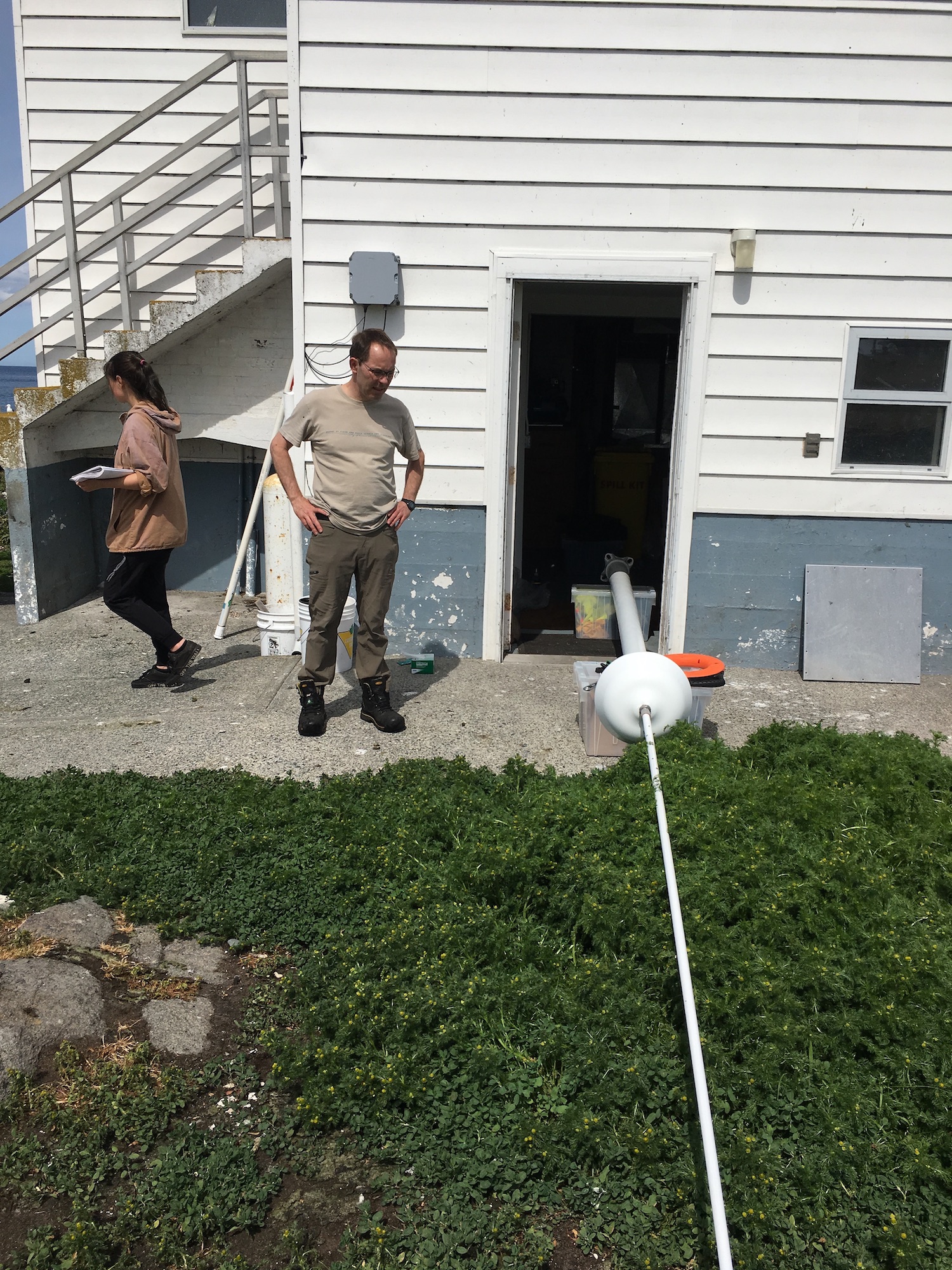
A lot of activity was going on today in the reserve. Guy drove out myself and Laura Verhegge and several others to attend to equipment at Race Rocks. Already there was a crew with Kevin of Oceans Network Canada who were reinstalling the CODAR sea surface monitor. This was last commented on in a log on September 28 Also accompanying us was Ed Weibe, of the UVic School of Earth and Ocean Sciences — EOS 110 Labs Vancouver Island School-Based Weather Station Network http://victoriaweather.ca , who monitors the Davis weather station for our weather page on this site and the UVic Schools Weather program. He was there to change the humidity sensor and check on the equipment. Lucinda Leonard was along to take down the GPS earthquake monitoring equipment after its successful deployment for the past week. (See the May 10 log)
-
- Laura and Lucinda
-
- Location of second GPS station
-
- Lucinda Leonard dismantling equipment
-
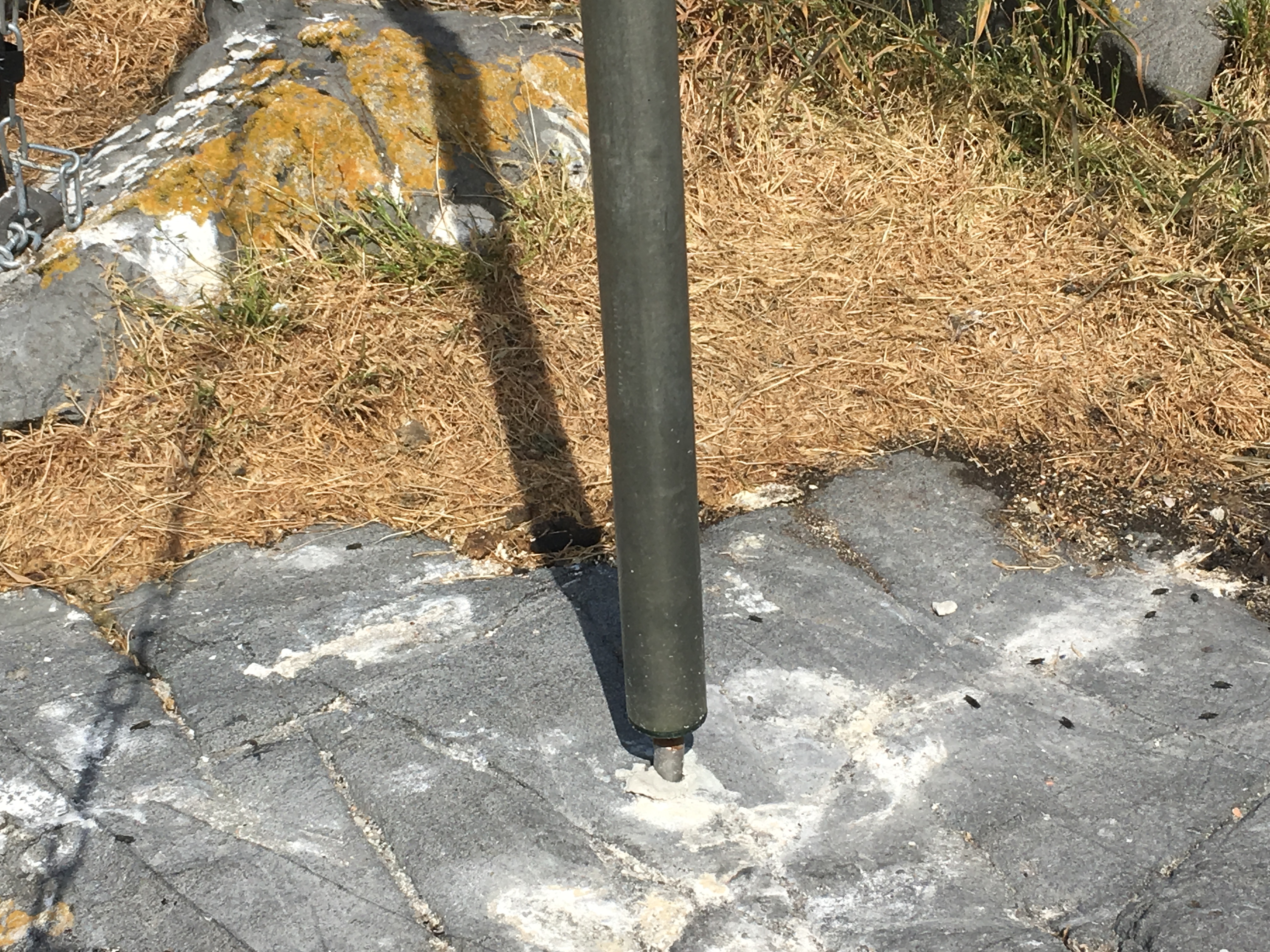
- Location of Original GPS marker.
-
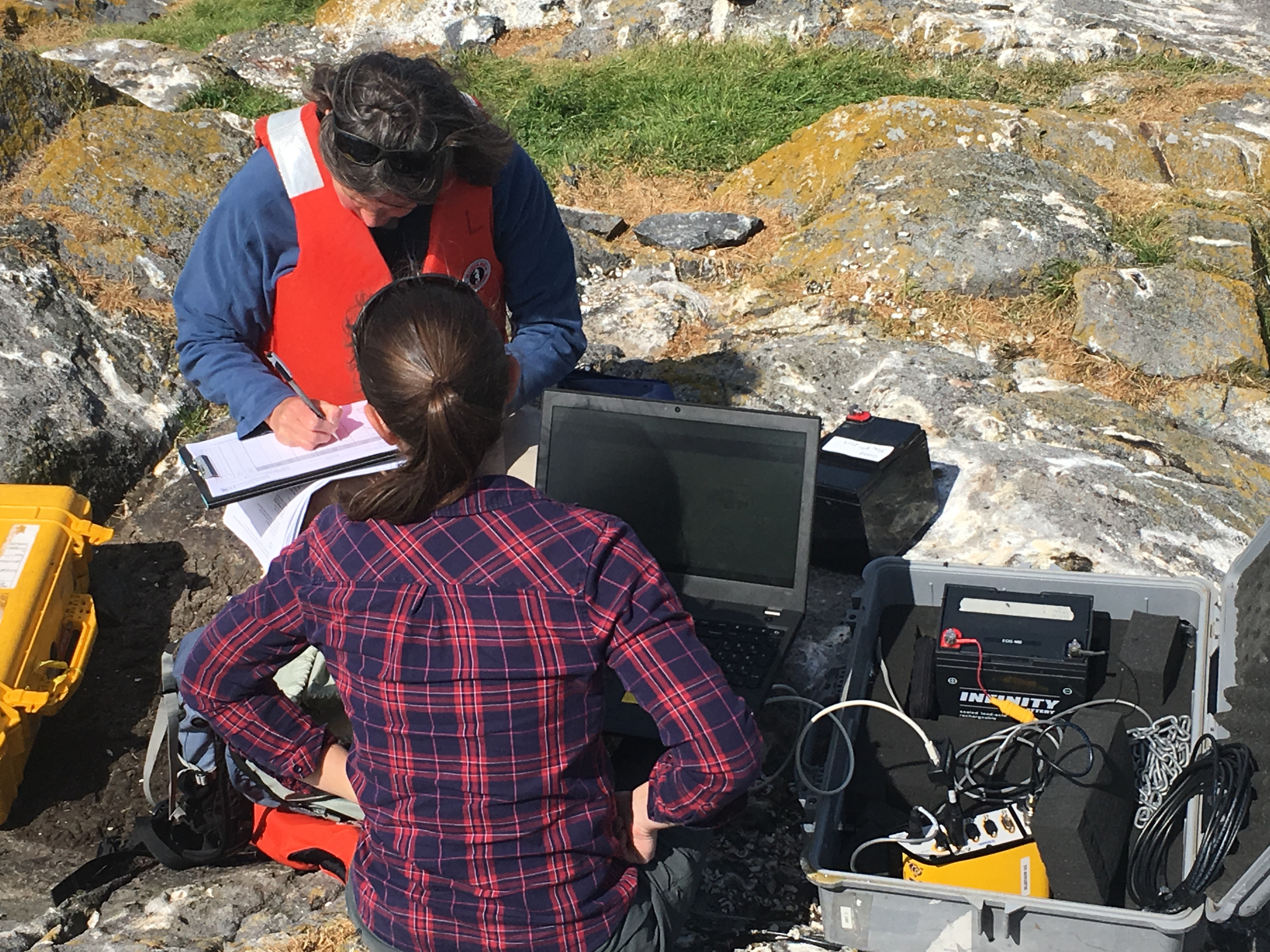
- Laura recording data points
-
- Second GPS station
The other activity going on was the installation of a CODAR monitor by the crew with Kevin from Oceans Network Canada.
-
- new antenna
-
- carrying antenna to installation location
-
- base for the antenna
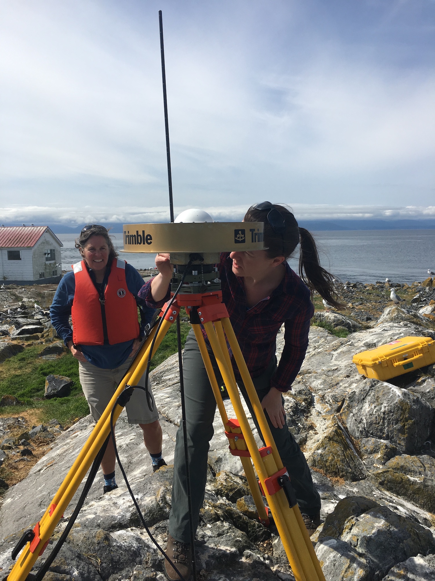
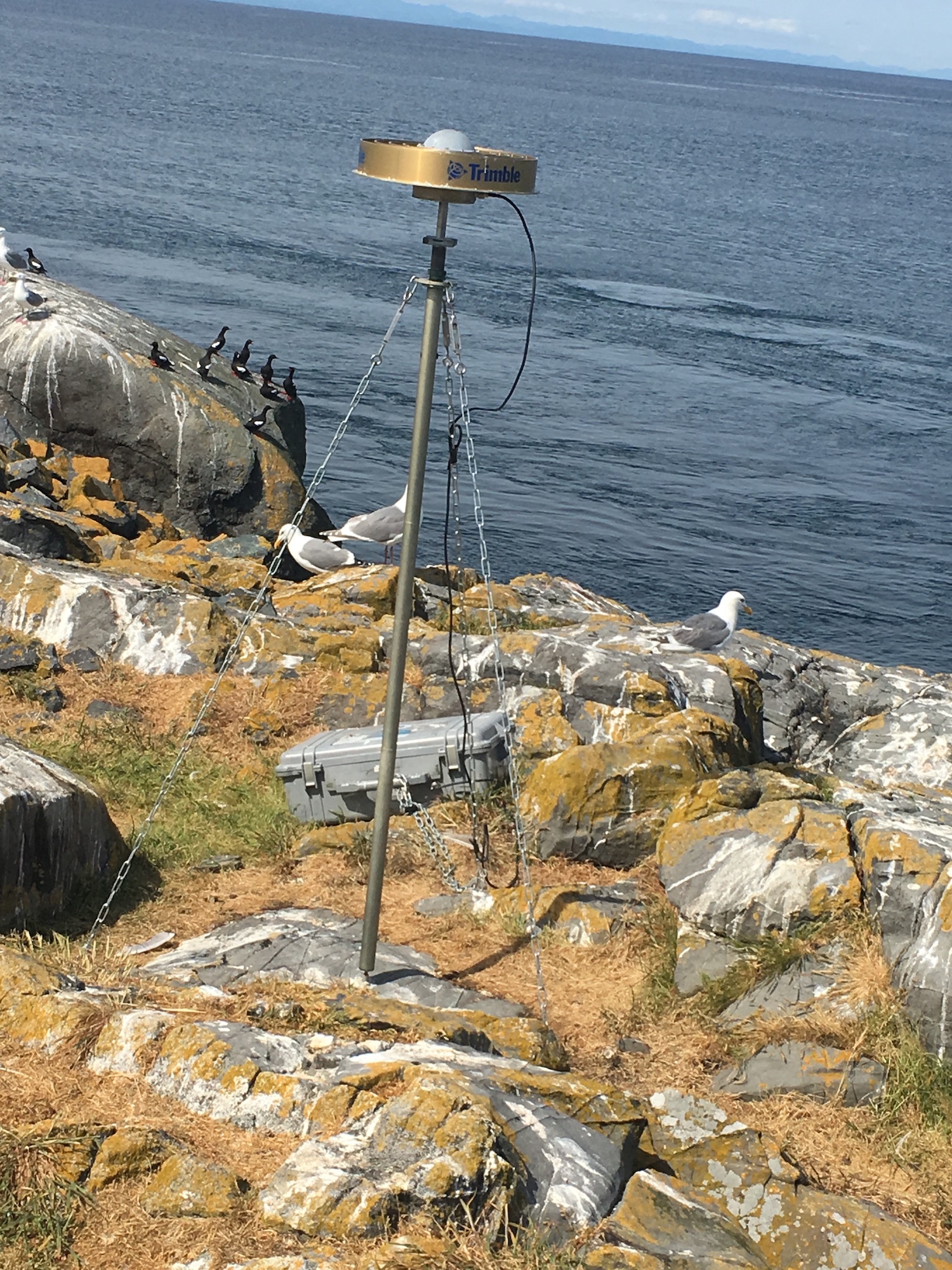
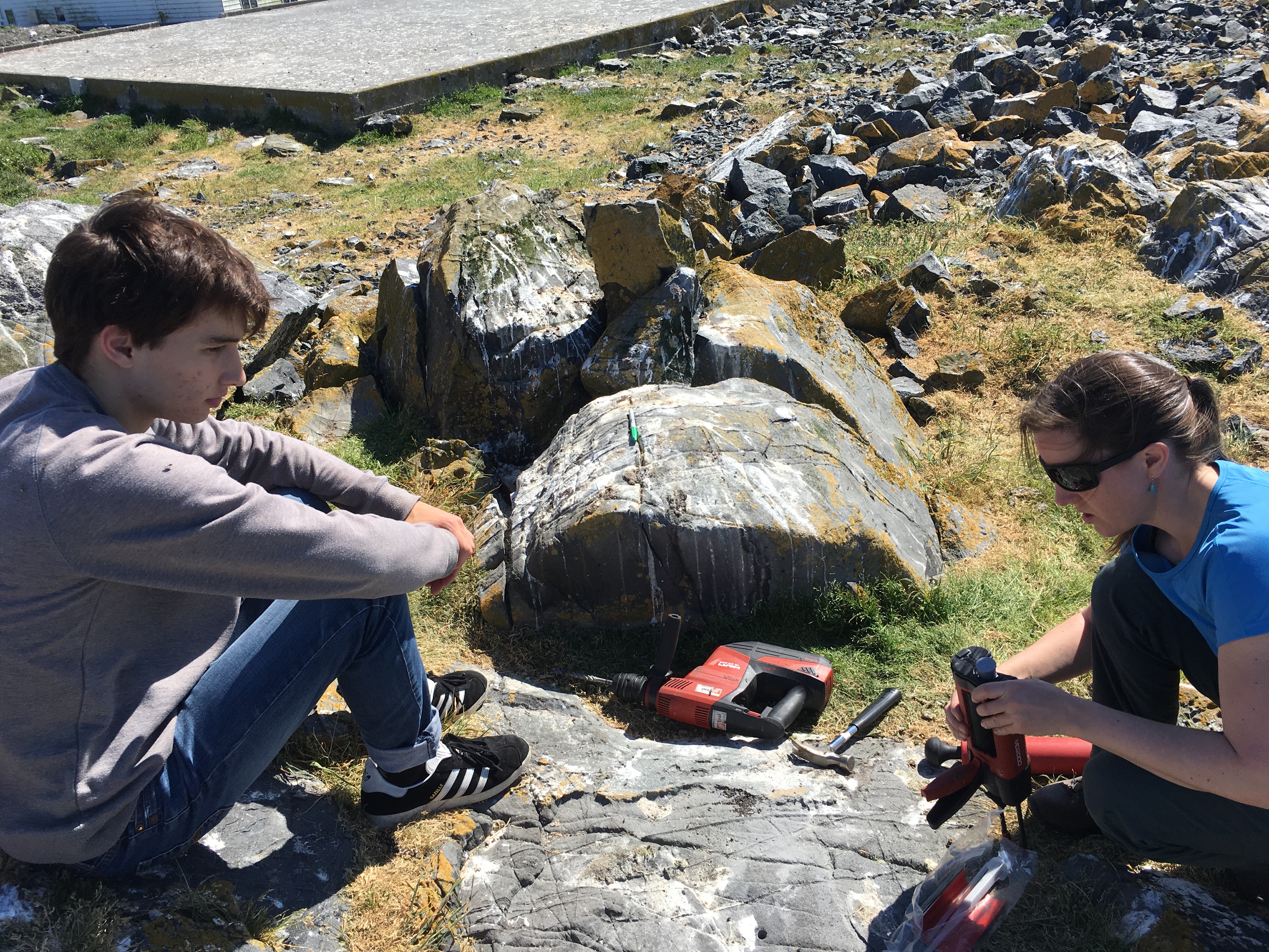
GPS Survey for Earthquake Hazard Assessment on Southern Vancouver Island
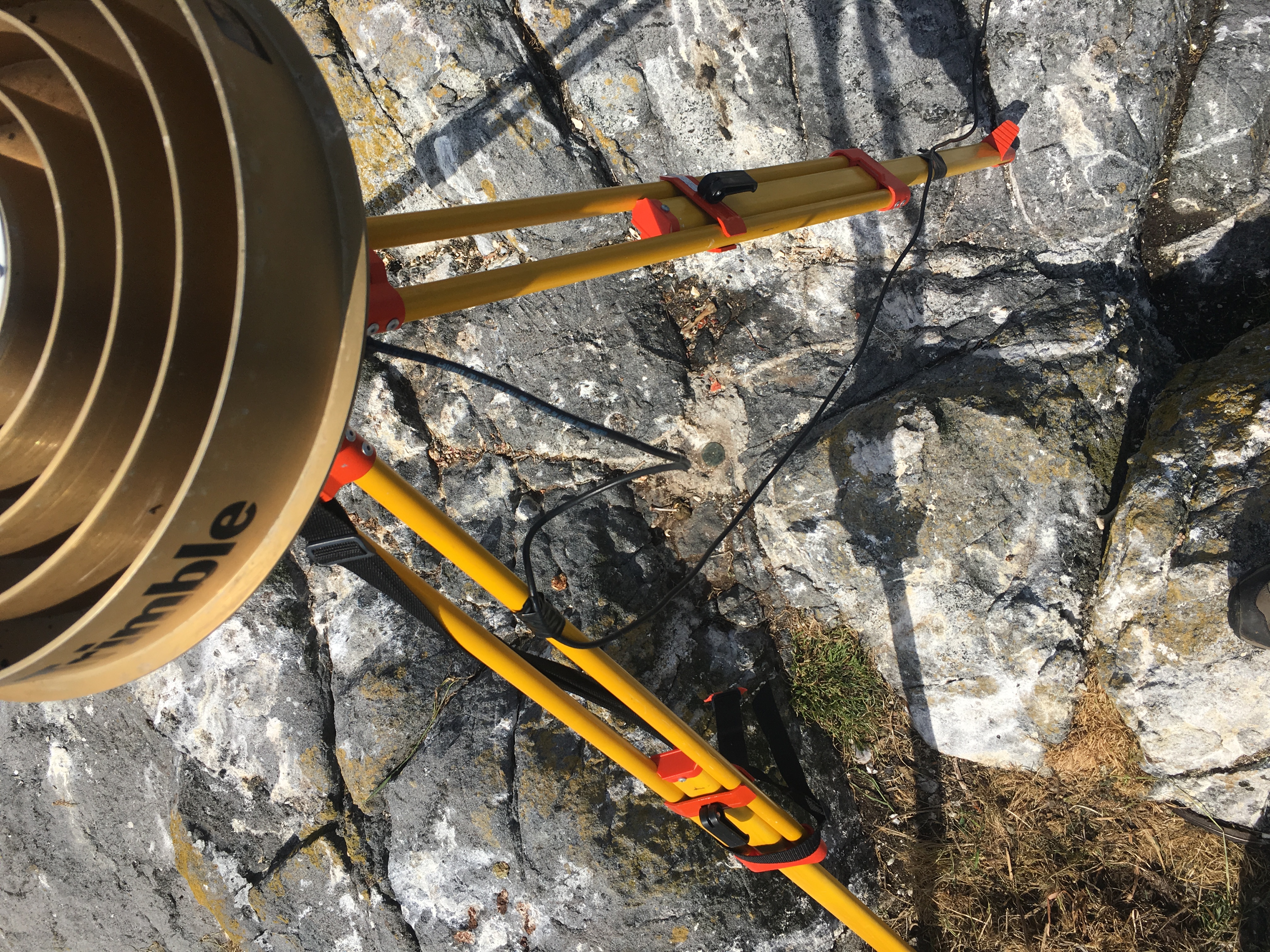
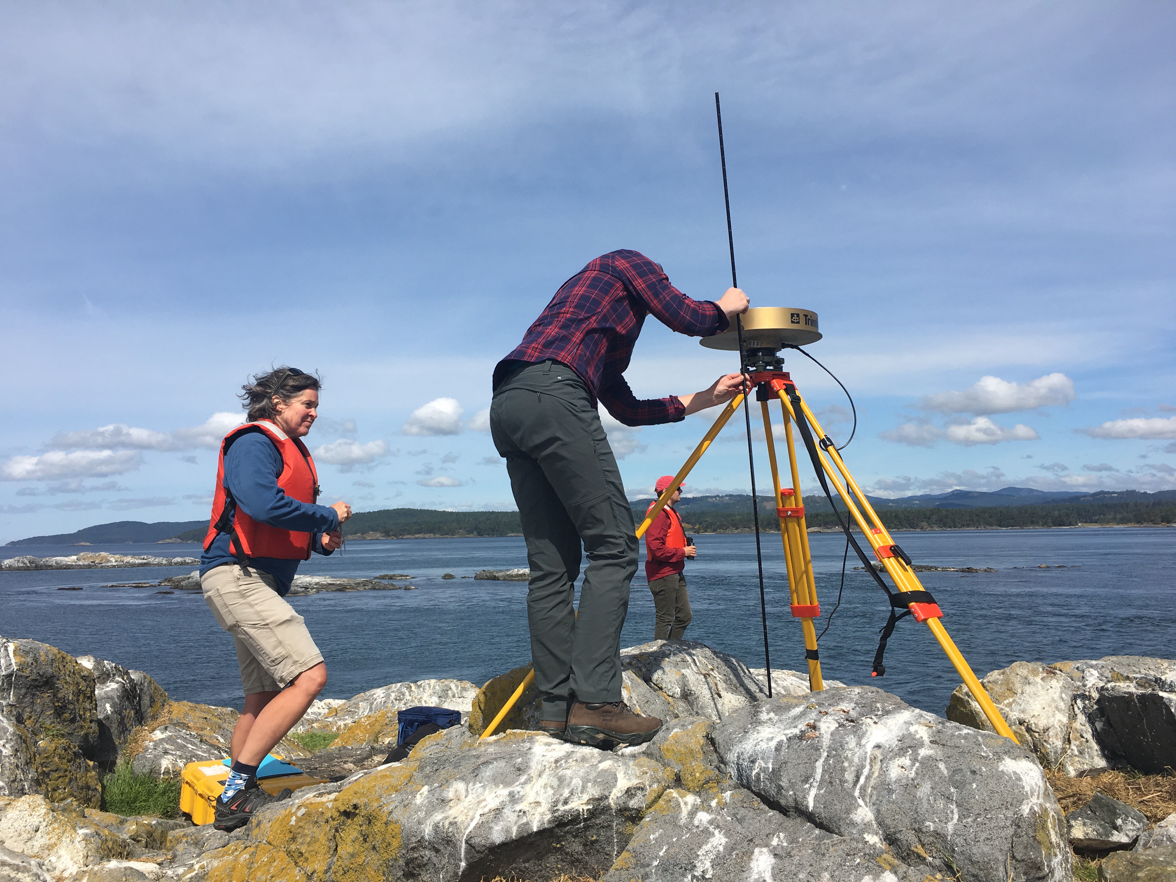
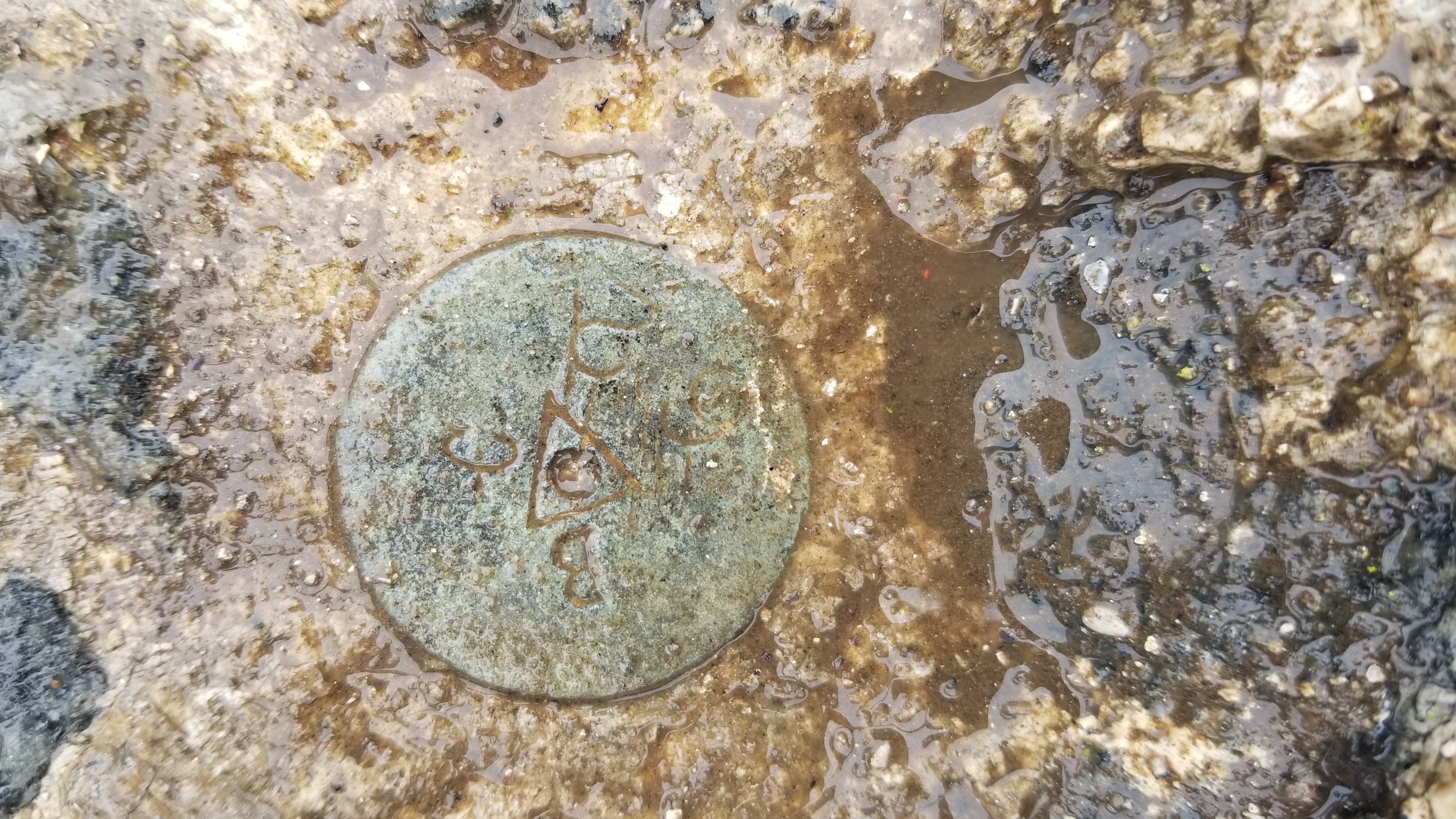
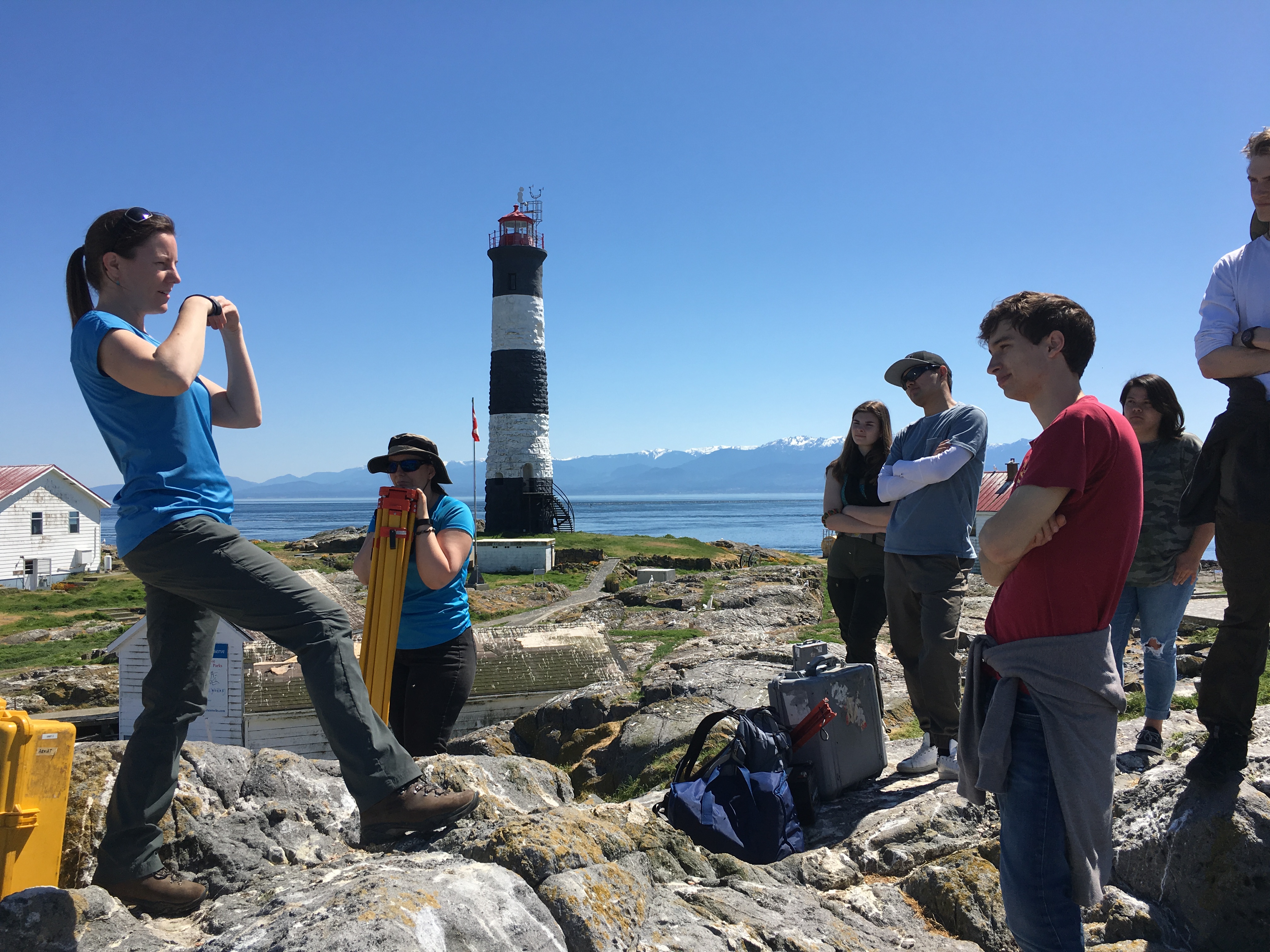
I accompanied Lucinda Leonard and two students from UVIc Megan Caston and Yijie Zhu – they are both working towards Masters degrees in Geophysics, working on earthquakes and faults to Race Rocks along with 6 students from Pearson College for the installation of two GPS stations. Many years ago , perhaps as early as 1991, this plug had been installed a meter in front of the Camera 5 location , and it had not been rechecked since. Laas was able to get this picture of it to verify that it was still there .
-
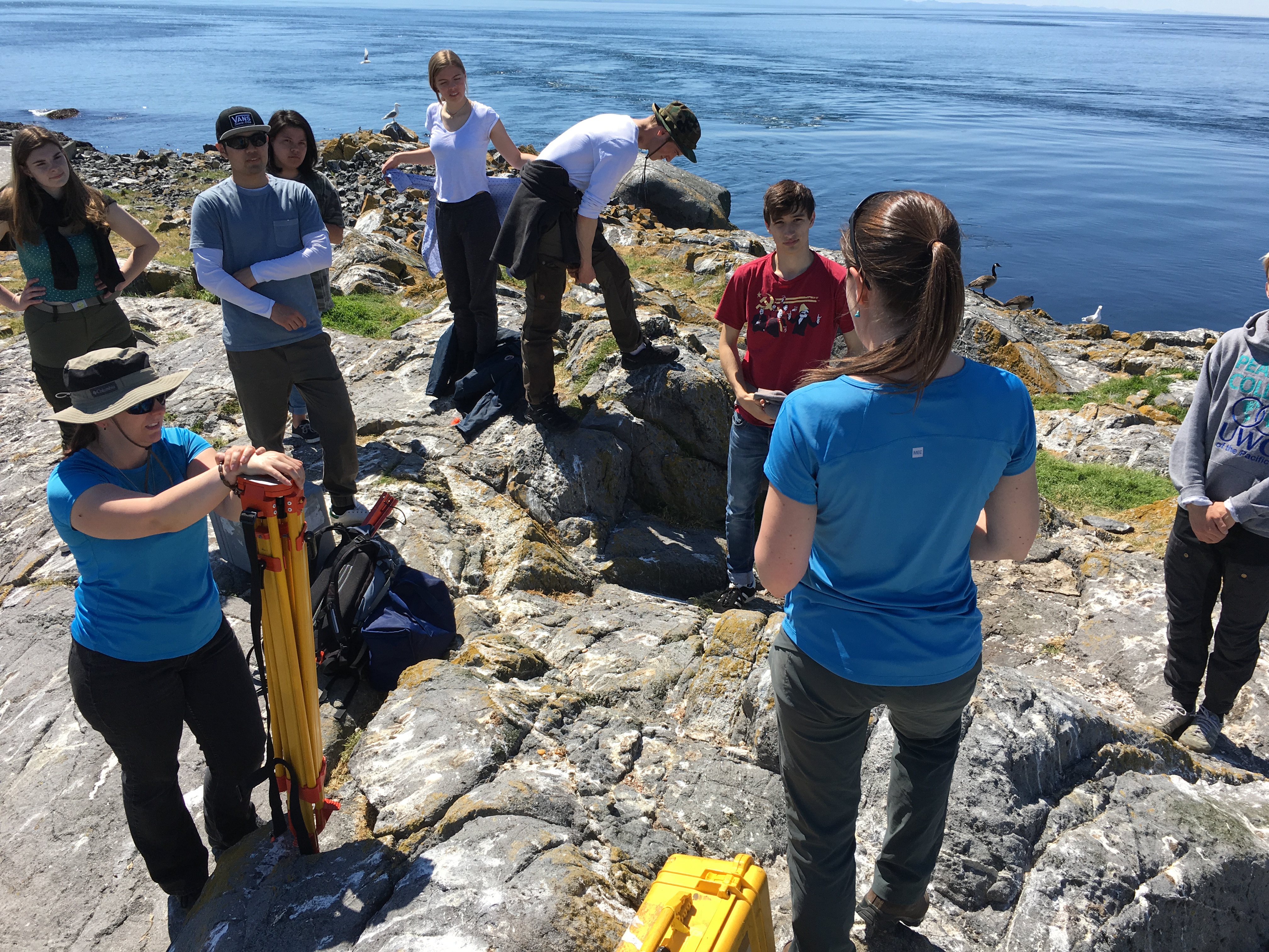
- Lucinda explaining the project to the Pearson College marine Science students
-
- Pearson College students
-
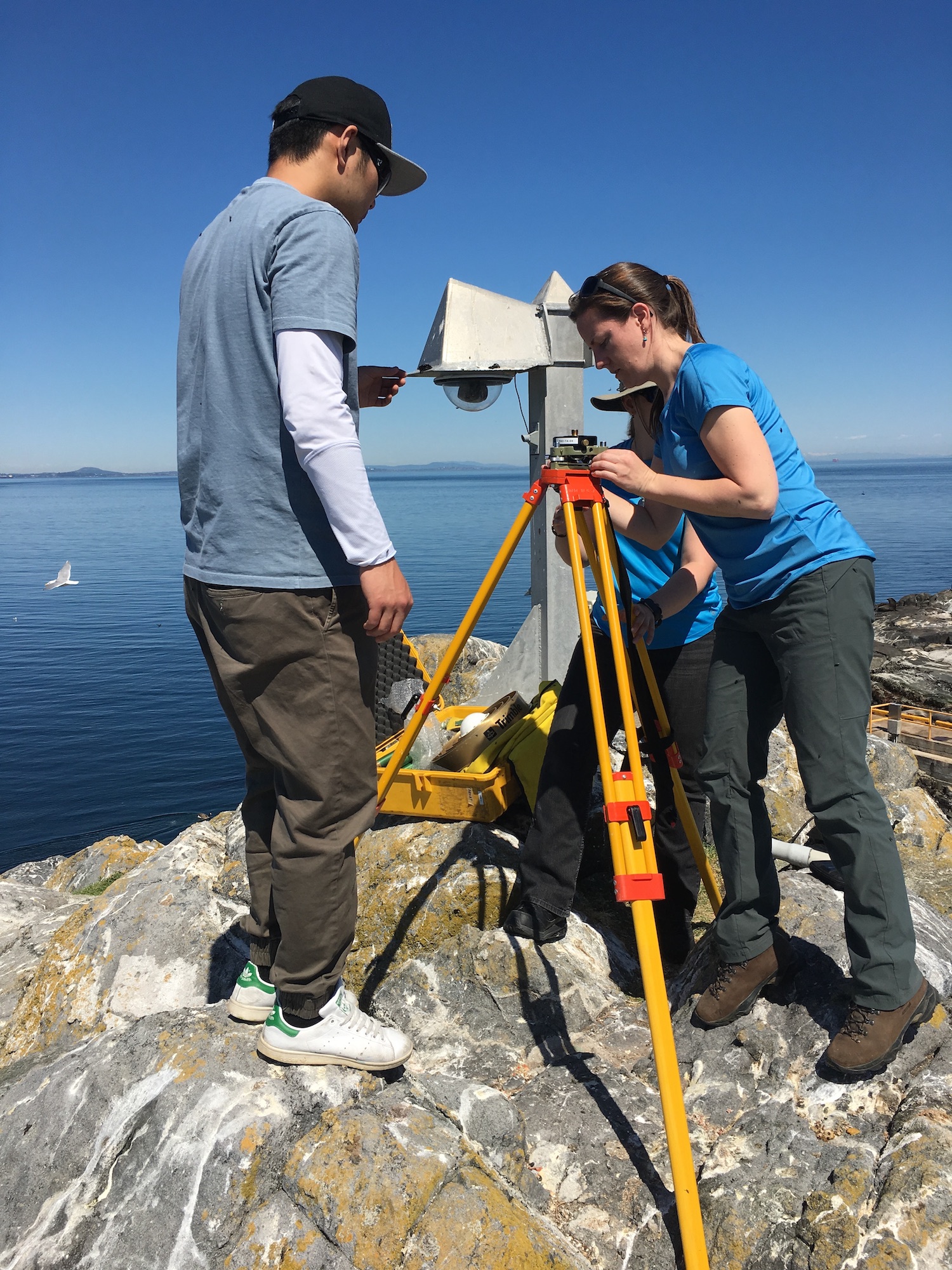
- A tripod fixes the sensor over the marker
-
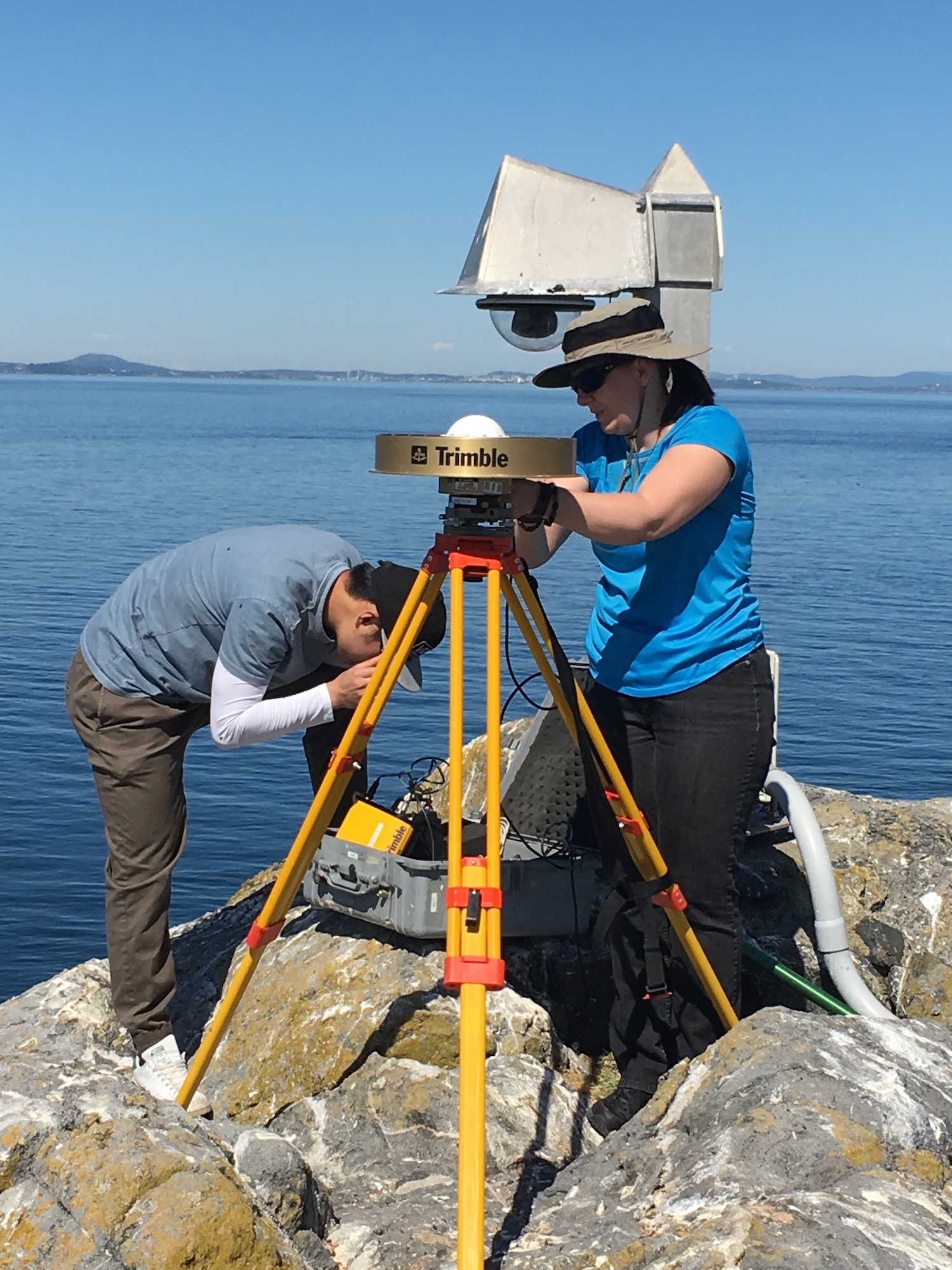
- UVic students Megan and Yijie
-
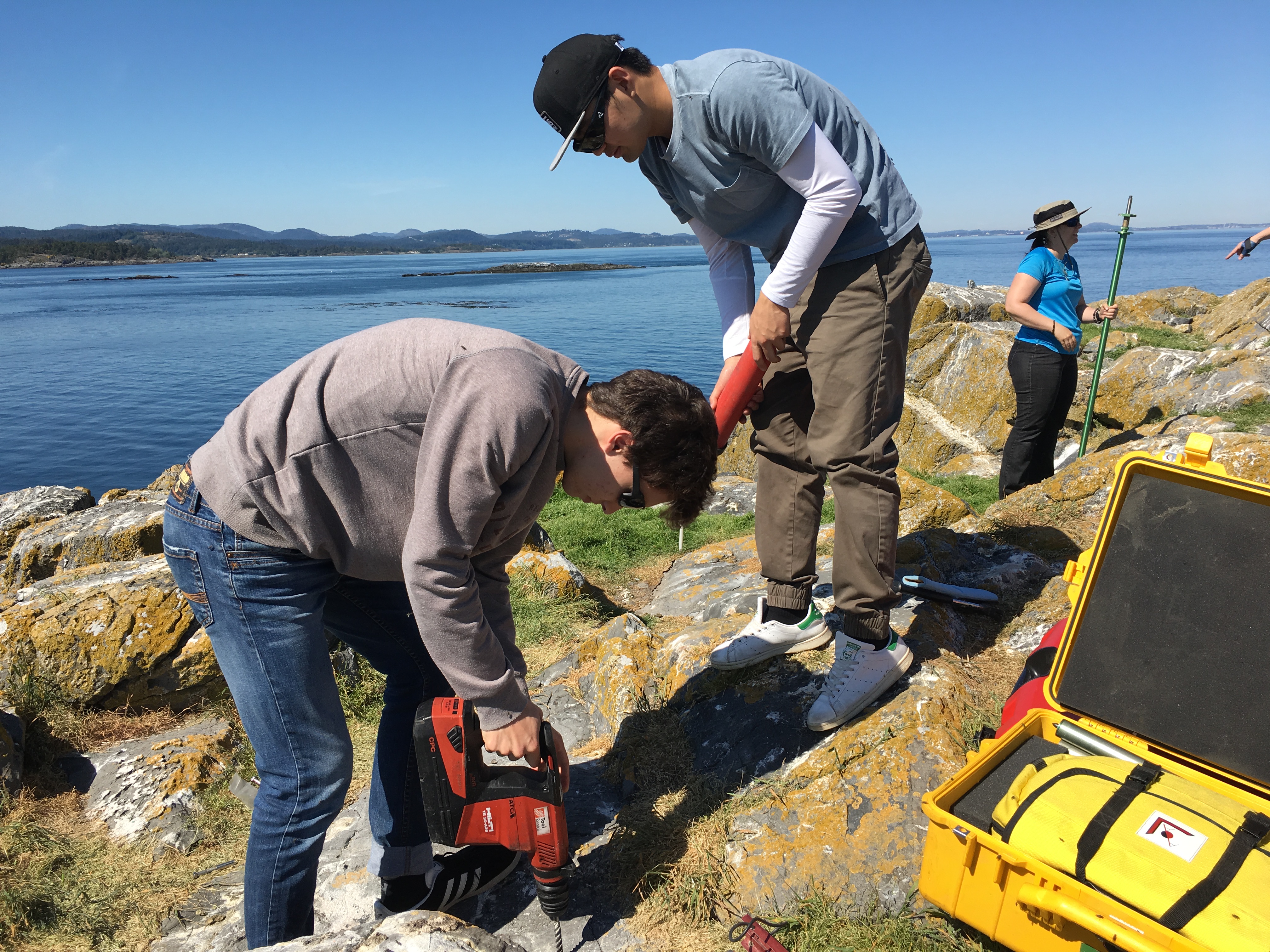
- Pearson College student drilling hole for tripod anchor in new location 5 meters west of the old one.
The following is the research proposal by Lucinda Leonard, Assistant Professor (Geophysics) School of Earth and Ocean Sciences, University of Victoria PO Box 1700 STN CSC, Victoria, British Columbia, Canada V8W 2Y2
GPS Survey for Earthquake Hazard Assessment on Southern Vancouver Island
Participants: Lucinda Leonard, Assistant Professor, School of Earth and Ocean Sciences, University of Victoria
Julie Elliott, Assistant Professor, Purdue University
Yan Jiang, Research Scientist, Natural Resources Canada, and Adjunct Professor, University of Victoria 2-3 students will also take part in the fieldwork.
Objectives:
(1) To quantify seismic hazard of crustal faults on southern Vancouver Island. (2) To improve understanding of crustal deformation in subduction zone forearcs.
Scope of fieldwork:
The research project will establish and survey a relatively dense network of high-precision Global Positioning System (GPS) sites across fault zones on southeastern Vancouver Island that may host significant earthquakes. The 2018 survey will involve temporary instrument deployments at a number of pre-existing survey markers as well as new markers emplaced in bedrock. We anticipate future deployments every 1-2 years over the next 5-10 years.
Rationale:
Southeastern Vancouver Island is a region of high seismic hazard due to its location above the Cascadia subduction zone – the region is susceptible to damage from: earthquakes on the Cascadia megathrust fault offshore (magnitude ~9; similar to the devastating 2011 tsunamigenic Japan earthquake), deep earthquakes beneath the Salish Sea and Puget Sound (up to magnitude ~7; e.g., 2001 earthquake in Nisqually, Washington, that caused minor damage in Victoria), and earthquakes on poorly-understood shallow crustal faults (up to magnitude ~7.5; similar to the 2011 damaging earthquake in Christchurch, New Zealand). Crustal earthquakes, although smaller in magnitude than megathrust events, may produce strong shaking in urban areas due to their shallow source and possible close proximity. Modelling of a scenario crustal earthquake beneath the City of Victoria estimates extensive damage to 64% of building stock, 75% of the water pipeline system, and 90% of the sewer pipeline system in the city (VC Structural Dynamics Ltd., 2016).
Crustal faults remain poorly understood in the region, although recent progress includes the identification of surface-rupturing Holocene earthquakes on the Leech River fault (Morell et al., 2017) and its likely offshore equivalent, the Devil’s Mountain fault (Barrie and Greene, 2018). Fault mapping and trenching are important to determine the maximum magnitude of past and future earthquakes on individual fault strands, but these methods cannot provide accurate estimates of slip rates on fault zones, as required for input into seismic hazard assessments. GPS surveying can be used to track the relative motion of survey markers over time; a sufficiently dense GPS network can be further used to identify the location of active faults and to quantify their slip rates (e.g., Marechal et al., 2015). The existing network of continuous GPS stations on southeastern Vancouver Island is inadequate for this purpose, e.g., there are only three stations within 20 km of the active Leech River fault zone. Campaign-style deployments, repeated every 1-2 years over a time-span of 5-10 years, will provide the greater density of survey locations needed to assess strain build-up on fault zones. Several sites were established in 1991 and re-surveyed in 1996 (Henton, 2000; Mazzotti et al. 2003) – we propose to re-occupy these sites, where possible, and to establish a denser network of campaign GPS sites for temporary deployments (2-4 days at each site).
1
Methodology
Site locations:
Site requirements: accurate GPS positioning (to within 1 mm) requires the GPS antenna to have a good view of the sky in order to maximize the satellite signals received. It also requires a marker to be emplaced in a stable substrate, ideally bedrock. Thus bedrock hilltops provide optimum site locations. In this region, many optimal locations are located within parks.
Proposed deployments include 5 pre-existing sites, in addition to ~16 new sites, at an average of ~3 km spacing perpendicular to the Leech River fault zone and adjacent faults offshore (Figure 1; Table 1). The greater number of sites to the north of the fault zone reflects greater accessibility over a larger land area in this region.
Figure 1. Proposed locations of campaign GPS sites. Also shown are the locations of continuous GPS sites, pre-existing campaign GPS sites, and mapped faults.
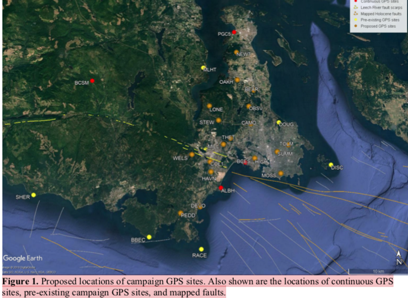
Table 1. Locations of existing and proposed GPS campaign sites available by contacting the research proponenet
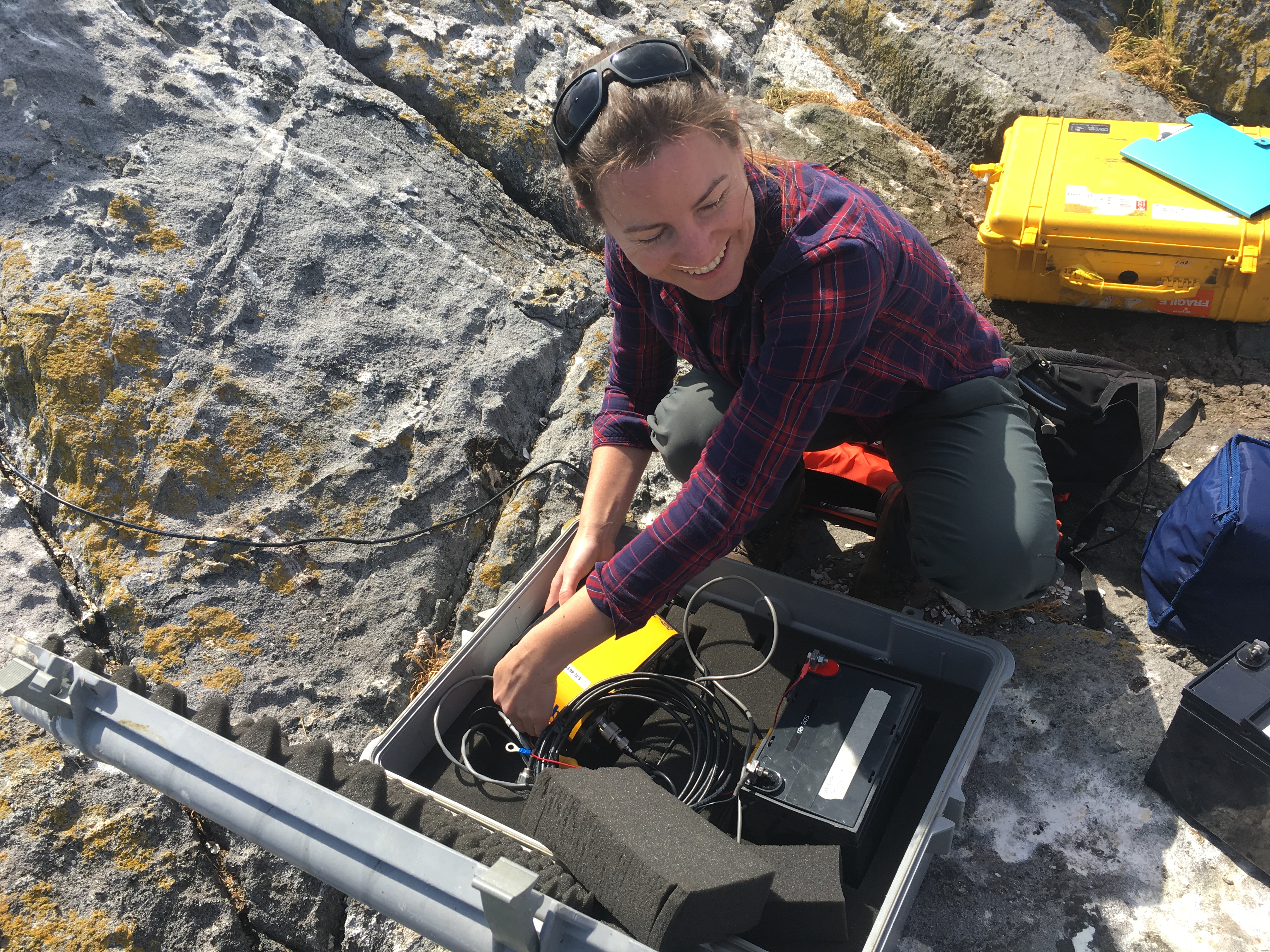
For a continuous period of 2-4 days at each site (maximum of once per year), a 1.7-m high mast with GPS antenna will be set up over an existing or new marker in the bedrock at each site, attached by cable to a receiver in a locked box on the ground. During deployment, the mast will be secured to the anchors using chains (Fig. 2a). At sites not conducive to the mast set-up, a tripod (Fig. 2b) or spike mount (Fig. 2c) will be used instead. New sites will be established by using epoxy to fix stainless steel marker pins into the bedrock. These will penetrate 6 inches into the rock, with a diameter of 0.5 inches, to lie flush with the ground surface. For mast sites, three stainless steel anchor bolts will also be bolted into the rock to a depth of ~2 inches, each attached to a 2-inch diameter stainless steel ring flush to the ground, at a distance of ~0.5 m from the central marker.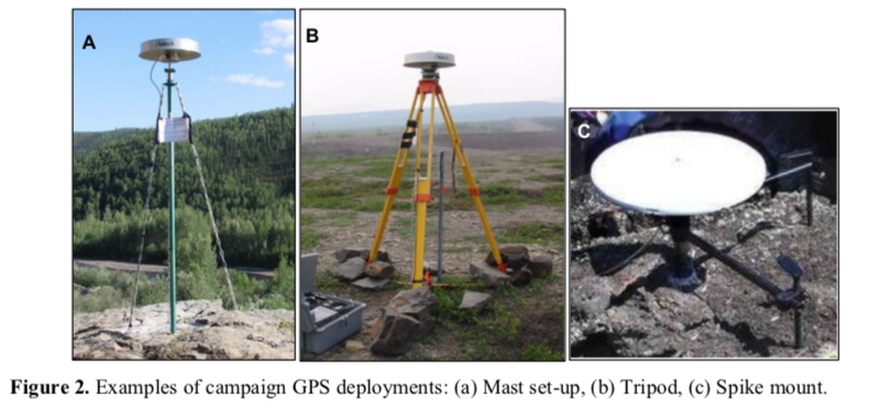
Approximate schedule for 2018 fieldwork:
The fieldwork will be carried out in August 2018, with each site being surveyed for 2-4 days. The proposed schedule is shown in Table 2 below, although actual dates may differ.
Table 2. Approximate schedule for fieldwork in August 2018 Approx. Dates Tasks
Aug 1 Aug 2 Aug 3 Aug 4 Aug 5 Aug 6 Aug 7 Aug 10
Aug 11 Aug 12 Aug 13 Aug 14 Aug 15 Aug 16 Aug 17 Aug 18
Team 1: Deploy PBHY, HIGH, SHER
Team 1: Deploy MLHT, TOLM, check others, babysit TOLM
Team 1: Stay at TOLM, check others
Team 1: Babysit TOLM, Demob PBHY, HIGH, TOLM (after 5 pm) Team 1: Demob MLHT, Deploy HAVN
Team 1: Check HAVN
Team 1: Demob HAVN after 5 pm
Team 1: Paperwork; deploy BEAR, STEW
Team 2: Deploy BBEC, DEVO, MILL
Team 1: Deploy OAKH, DOUG, check BEAR, STEW, babysit DOUG Team 2: Deploy PEDD, check BBEC,DEVO, MILL
Team 1: Babysit DOUG, check STEW, OAKH, BEAR
Team 2: Check DEVO, PEDD, BBEC, MILL
Team 1: Demob STEW, BEAR, Babysit DOUG then demob after 5 pm Team 2: Demob BBEC, DEVO, MILL
Team 1: Demob OAKH, Deploy THET, DISC (by boat)
Team 2: Demob PEDD, deploy LONE, CAMO
Team 1: Deploy WELS, MOSS, SUMM
Team 2: Deploy OBSV, check LONE, CAMO
Team 1: Check WELS, THET, MOSS, SUMM
Team 2: Check LONE, CAMO, OBSV
Team 1: Demob DISC (boat), THET
Team 2: Demob LONE, CAMO
Team 1/2: Demobilize WELS, MOSS, SUMM, OBSV
4
Plans for on-site security, site control and general safety?
The deployment of passive GPS equipment poses little risk to the public. Flagging will be placed on the equipment to mitigate any potential tripping hazards. Signs will be posted at all sites, with the following text (correct dates to be inserted): “Surveying for earthquake hazard study in progress from August 3-6 – please do not disturb. For more information, please contact Lucinda Leonard, School of Earth and Ocean Sciences, University of Victoria: 778-676-9621 or lleonard@uvic.ca”. At locations that are popular with the public, sites will be manned during daylight hours. Sites that see less pedestrian traffic will be visited 1-2 times per day during the deployment.
Data processing and analysis:
Geodetic data will be processed using standard routines to determine precise daily average locations for each site. Positional time series will be analyzed to provide site motions (direction and rate of motion) in a North America reference frame. Analysis of relative motion between sites will enable determination of strain across fault zones and improve seismic hazard assessment for southern Vancouver Island.
References:
Barrie, V., and H. G. Greene (2018), The Devils Mountain Fault zone: an active Cascadia upper plate zone of deformation, Pacific Northwest of North America, Sedimentary Geology, v. 364, p. 228-241, doi: 10.1016/j.sedgeo.2017.12.018.
Henton, J.A. (2000), GPS studies of crustal deformation in the northern Cascadia subduction zone. Ph.D. thesis, Univ. Victoria, Victoria B.C., Canada, 169p.
Marechal, A., S. Mazzotti, J.L. Elliott, J.T. Freymueller, and M. Schmidt (2015), Indentor-corner tectonics in the Yakutat-St. Elias collision constrained by GPS, Journal of Geophysical Research, v. 120, p. 3897-3908, doi: 10.1002/2014JB011842.
Mazzotti, S., H. Dragert, J. Henton, M. Schmidt, R. Hyndman, T. James, Y. Lu, and M. Craymer (2003), Current tectonics of northern Cascadia from a decade of GPS measurements. J. Geophys. Res. 108(B12):2554.
Morell, K. D., C. Regalla, L. J. Leonard, C. Amos, and V. Levson (2017), Quaternary rupture of a crustal fault beneath Victoria, British Columbia, Canada, GSA Today, v. 27, no. 3.
VC Structural Dynamics Ltd. (2016), Citywide seismic vulnerability assessment of the City of Victoria, Report prepared for the corporation of the City of Victoria, Victoria, BC, Canada, 43p, available online at: http://www.victoria.ca/assets/Departments/Emergency~Preparedness/Documents/Citywide- Seismic-Vulnerabilities-Assessment.pdf
See the follow-up when the instrument was removed on the May 15 log
Polygonum aviculare: prostrate knotweed – The Race Rocks Taxonomy
Polygonum aviculare
I noticed a particularly thriving population of the invasive prostrate knotweed this spring . It is typically successful in heavily compacted areas and adjacent to the sidewalks. Also it is probably not favoured by Canada geese, as with most of the successful invasive species on the island. See also: https://racerocks.ca/polygonum-aviculare-prostrate-knotweed-the-race-rocks-taxonomy/
| Kingdom: | Plantae |
| Clade: | Angiosperms |
| Clade: | Eudicots |
| Order: | Caryophyllales |
| Family: | Polygonaceae |
| Genus: | Polygonum |
| Species: |
P. aviculare
|
| Binomial name | |
|---|---|
| Polygonum aviculare | |
 Return to the Race Rocks Taxonomy Return to the Race Rocks Taxonomyand Image File |
 The Race Rocks taxonomy is a collaborative venture originally started with the Biology and Environmental Systems students of Lester Pearson College UWC. It now also has contributions added by Faculty, Staff, Volunteers and Observers on the remote control webcams. The Race Rocks taxonomy is a collaborative venture originally started with the Biology and Environmental Systems students of Lester Pearson College UWC. It now also has contributions added by Faculty, Staff, Volunteers and Observers on the remote control webcams. |
Matricaria discoidea : pineapple weed, The Race Rocks taxonomy
The observation below was made in 2013/06/05 …
Several large areas where the grass was matted and smothered by the sealions hauling out last fall, now have a prolific growth of this newly arrived plant, Matricaria discoidea, or pineappleweed. These are the tallest growing samples of that plant I have seen. Another plant in the same areas is the fiddleneck, Amsinckia menziesii
This year the same situation appears in the areas trampled by the sealions last fall. This post shows how comfortable it is for the elephant seals.
Kingdom: Plantae
Clade: Tracheophytes
Clade: Angiosperms
Clade: Eudicots
Clade: Asterids
Order: Asterales
Family: Asteraceae
Genus: Matricaria
Species: M. discoidea
| Return to the Race Rocks Taxonomy and Image File |
| The Race Rocks taxonomy is a collaborative venture originally started with the Biology and Environmental Systems students of Lester Pearson College UWC. It now also has contributions added by Faculty, Staff, Volunteers and Observers on the remote control webcams. |
Nautichthys oculofasciatus (Sailfin Sculpin): The Race Rocks taxonomy
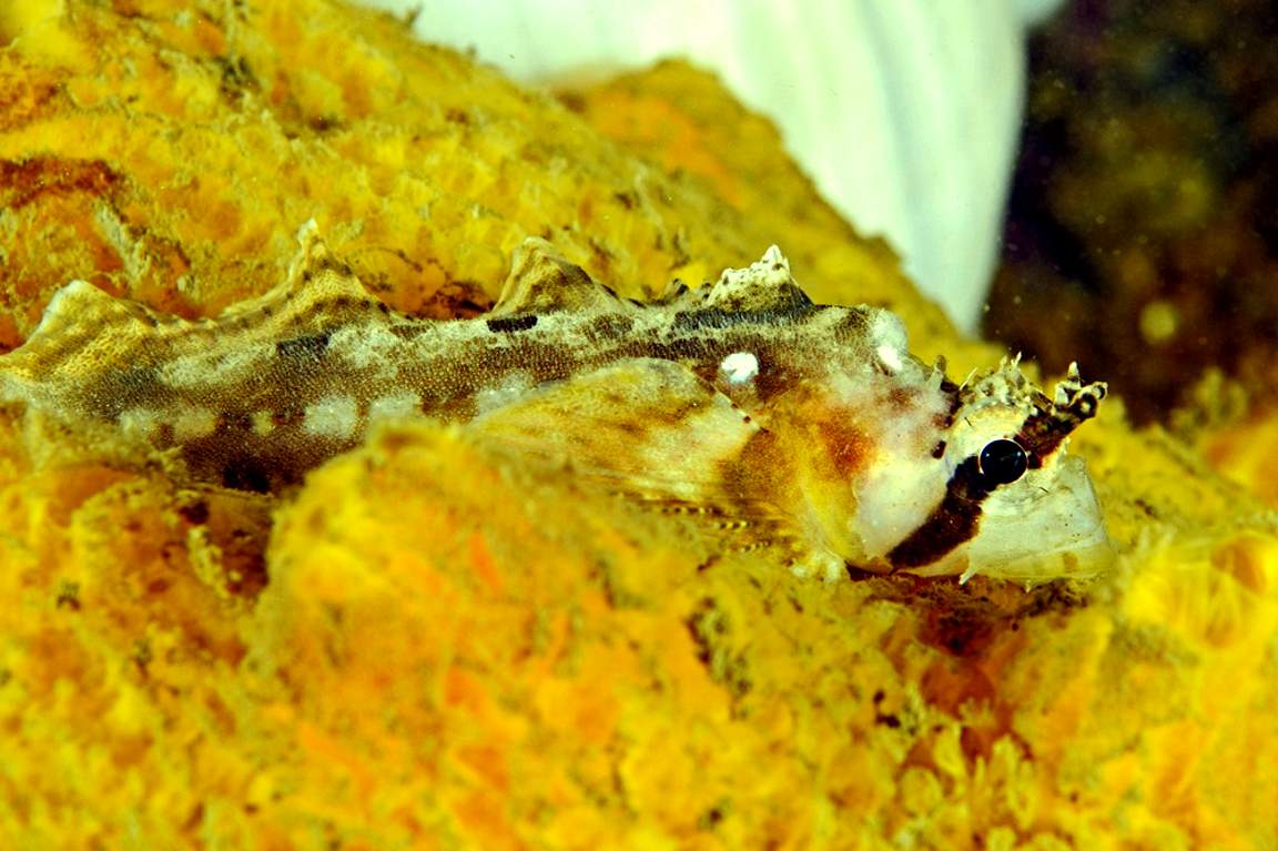
Sailfin Sculpin , Nauticthys oculofasciatus
(Aprox 20cm in length) Ryan took these pictures on a night dive in April, 2010.
-
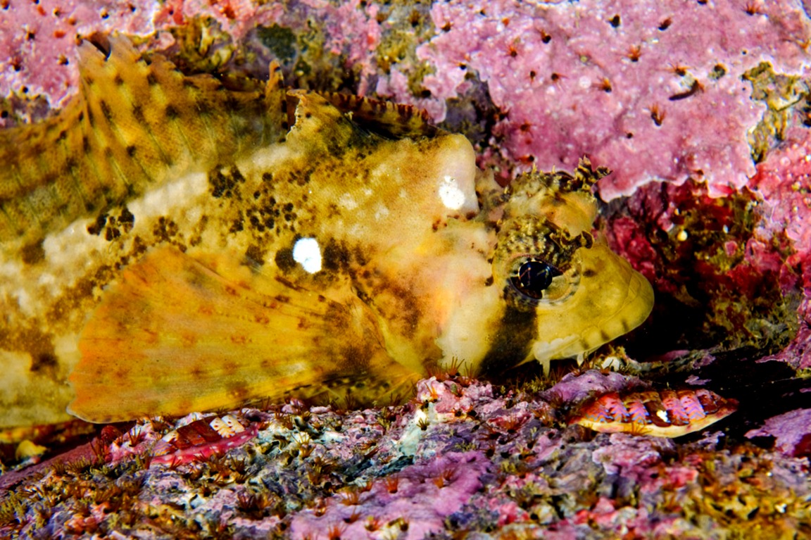
- The two individuals look slightly different, perhaps reflecting different sexes.
-
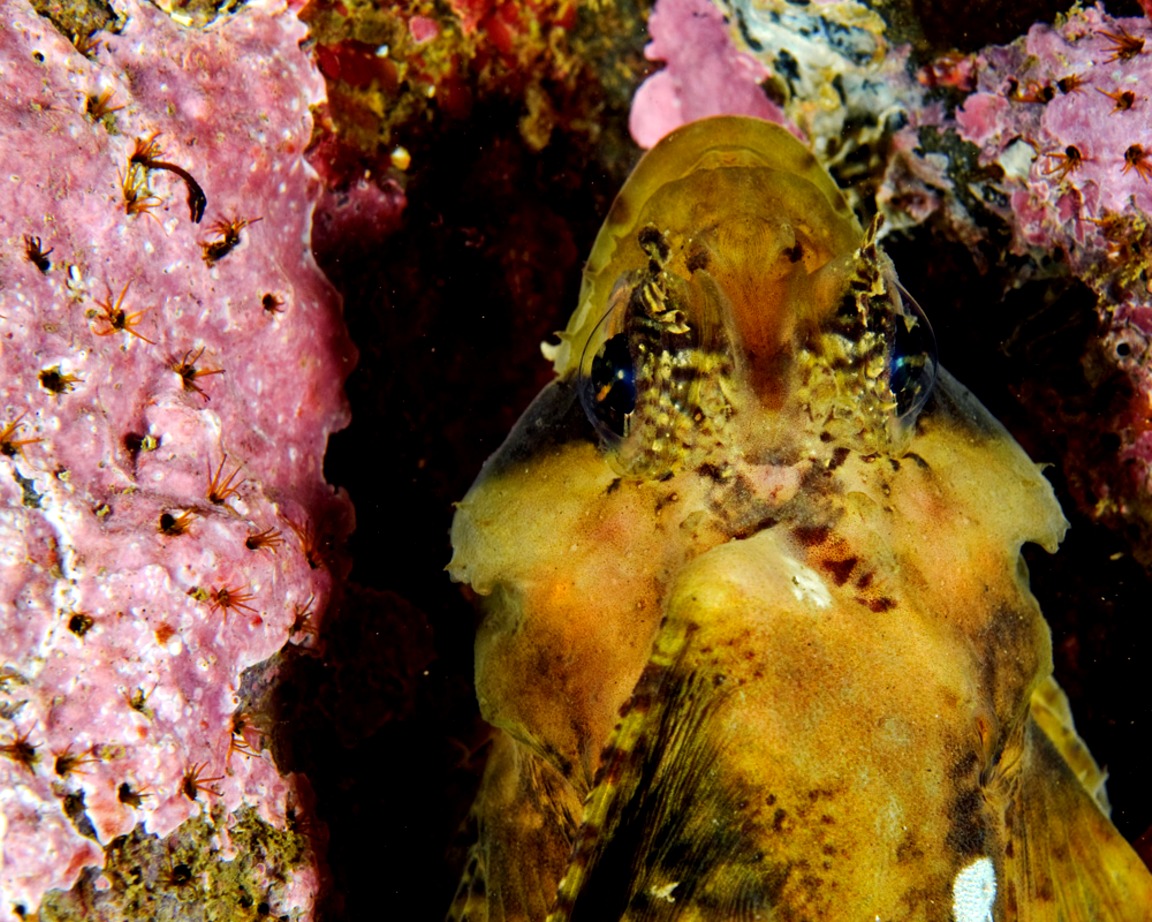
- Absent is the tall “sailfin” which is probably folded down as the individuals were in a resting state.
Domain Eukarya
Kingdom Animalia
Phylum Chordata
Sub-PhylumVertebrata
Class Scorpaeniformes
Order hemitripteridae
Family Cottidae
Genus Nauticthys
Species oculofasciatus Girard 1858
Common Name:Sailfin Sculin
|
Other Members of the Class Class Actinopterygii at Race Rocks.
|
| Return to the Race Rocks Taxonomy and Image File |
| The Race Rocks taxonomy is a collaborative venture originally started with the Biology and Environmental Systems students of Lester Pearson College UWC. It now also has contributions added by Faculty, Staff, Volunteers and Observers on the remote control webcams. March 15 2010 – Ryan Murphy |
Update on Tagged Elephant Seal Cow
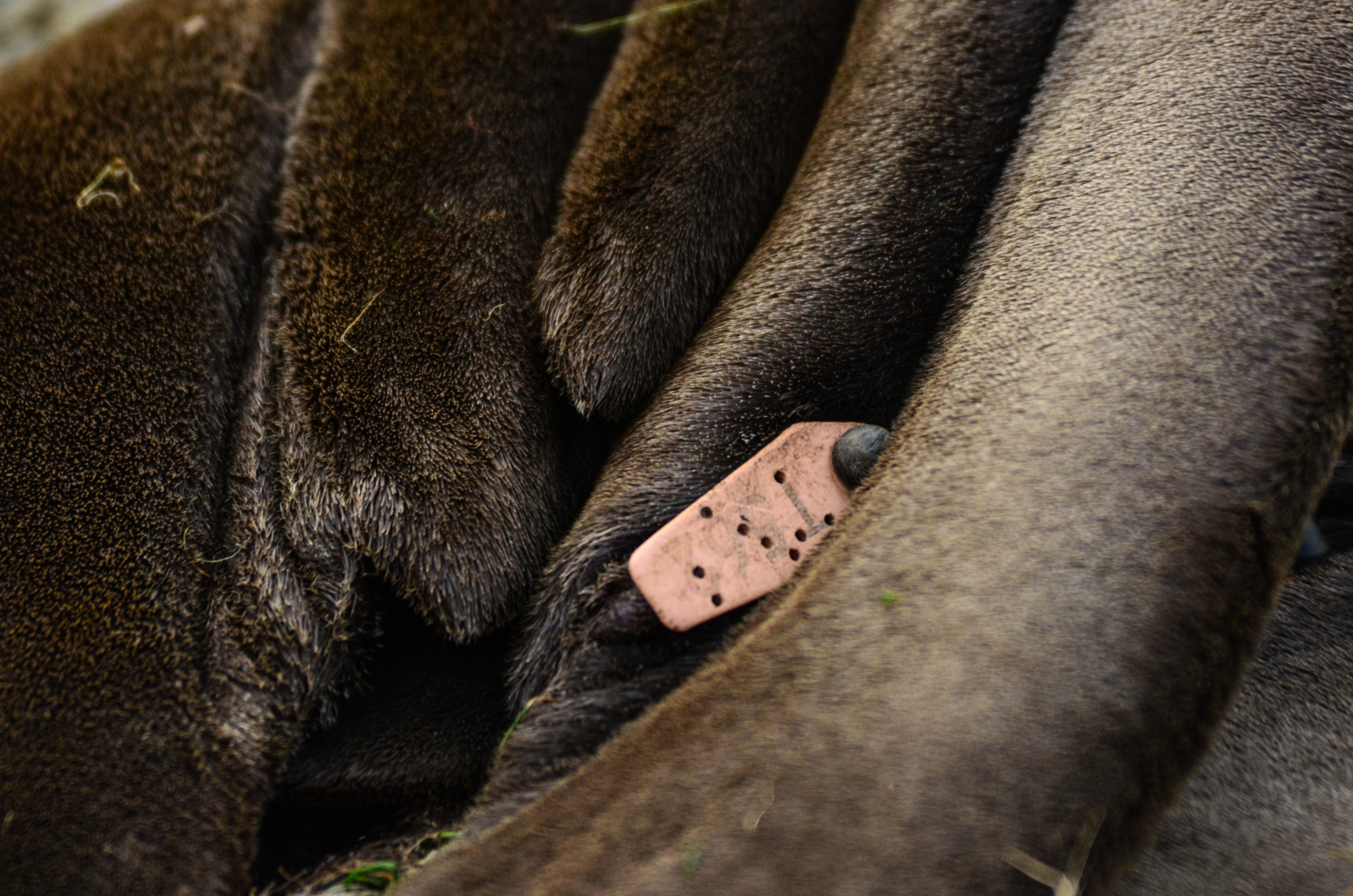
T 562 pink
Recently I sent this email to the folks who are in charge of the tagged elephant seal program in the US .” This year we have had three pups born The tag (on this website) for pups born here over the last few years is https://www.racerocks.ca/tag/
***********************************************************************************************
NOTE : The following link is connected to all the posts on this log relating to tagged elphant seals we have recorded at Race Rocks Ecological Reserve over the past 19 years
https://www.racerocks.ca/tag/tagged/
Today we received this information from Garrett Duncan, Farallon Program Biologist at Point Blue Conservation Science. www.pointblue.org :
The cow you re-sighted with a Pink tag T562 was born on the SE Farallon Island during the 2010-2011 breeding season and hasn’t been seen since. It’s mother’s name in our database was Peggy and she was likely born in the 1998-1999 breeding season in a colony further to the south, Piedras Blancas. She frequented the island every year between 1999 and 2011.
NEB Reconsideration Hearing Argument in Chief from the Board of FER
Argument in Chief EXECUTIVE SUMMARY for the
January 22, 2019 i
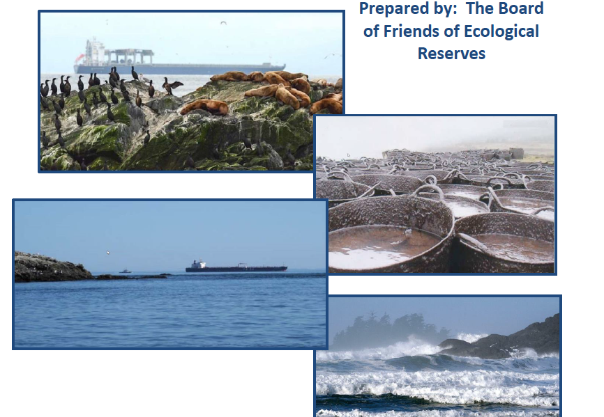
The National Energy Board (NEB) placed no new permit conditions on the Trans Mountain Expansion Project (TMX ) and proposed downgrading of the existing permit condition 131 to a recommendation (a non binding discretionary activity). NEB proposed that TMX permit condition 133 be strengthened with a new obligation on TMX to provide escort tugs to accompany Aframax tankers as far as Juliet Buoy at the western entrance the Strait of Juan De Fuca instead of the tug escort ending at Race Rocks as is the current practice. The Friends of Ecological Reserves (FER) supports adding tug escort to J-Buoy and understands this means these will need to be larger sea going tugs deployed. This is a significant improvement which will help mitigate the risk of tanker groundings and a dilbit spill in the rough waters of the western entrance of the Strait of Juan De Fuca. The Board of FER suggests additional permit conditions are warranted and outline these below.
We recommend to the NEB that Permit condition 131, which is a public outreach program focused on marine safety and tankers, be amended to become a public outreach program extending information on what the public should do and know in the event of a dilbit spill as dilbit is a toxic substance and a hazard to human health. By the NEB’s definition “The purpose of conditions is to mitigate potential risks and effects associated with a project so that the project can be designed, constructed, operated, and abandoned in a safe manner that protects the public and the environment”.
A public pre-spill outreach program is a modest recommendation in our view, and a necessary condition that NEB needs to include in the TMX permit conditions as there are no such conditions now. The need for the re-emphasis of condition 131 is grounded in the principle that risk bringers (TMX) have an obligation to help manage the risks they bring and that TMX can treat this as a cost of doing business.
FER recommends that NEB refocus permit condition 131 to be retained and that an extension continue this year and all subsequent years that the project is shipping, with wording such as;
“at least 3 months prior to commencing operations,
A summary of Trans Mountain’s consultation with Health Canada regarding a public outreach program on what to do in the event of a dilbit spill, and
Undertake a public outreach program to mitigate risk to public health, including:
i) the resources and information that Trans Mountain will provide or will present annually at public awareness forums, to clarify what to do and what not to do when there is a spill of toxic substance such as dilbit;
ii) the schedules of activities or presentations/workshops with fishing industry organizations, commercial and recreational vessel operators, marinas, Aboriginal groups, Municipal councils and first responders forums, schools and universities affected by a dilbit spill.
iii) any issues or concerns raised by Health Canada, Worksafe BC, Municipalities and how Trans Mountain has or will address these.”
The Board of FER seeks through these hearings, an end result that shifts shipping lanes away from the Victoria waterfront to better mitigate risk to human health and mitigate tanker spill risks to
Race Rocks, Trial Island and Oak Bay Islands Ecological Reserves. A more offshore shipping lane increases the time available to assist floundering tankers and prevent a grounding and increases the time available to deploy for an open ocean spill. Groundings are more likely to occur with the current nearshore tanker route to Brotchie Ledge pilot drop off area, near Ogden Point Coast Guard pilot boat anchorage. Three course changes are now needed for all shipping and this may increase the risk of collisions over more direct shipping lanes south of Constance Bank but still within Canadian waters. The NEB is aware of this important mitigation option available to Transport Canada (TC), but NEB mentions only lateral shifts in current shipping lanes within the context of a noise mitigation strategy in the Strait of Juan De Fuca and Haro Straits for Southern Resident Killer Whales. We recommend NEB add to their recommendation 7 to Governor in Council (GIC), the following wording: “movement of shipping lanes further offshore along the Victoria water front to south of Constance Bank”.
This request fits with the Ocean Protection Plan (OPP) with goals stated as “an initiative to prevent incidents and accidents, while enabling rapid science-based response actions in the event of a spill” TC has indicated a willingness to look at this but has not made a commitment on timelines hence the request to NEB to make GIC aware of this mitigation option to reduce spill risk and improve human health.
We seek from the NEB, inclusion of TMX permit condition(s) that establish a financial obligation for TMX. A TMX permit condition to support long-term research and monitoring to improve marine research and baseline environmental monitoring over the life of the TMX project. We reason that such a long-term commitment is necessary to understand how to manage dilbit risk and ecosystem restoration prior to a dilbit spill. TMX and the oil exporters who use the pipeline, bring risk over the life of their project, so it is reasonable that the oil exporting industry remains involved with research to understand how to improve mitigation of their product. A long-term obligation to fund environmental research, improvements in spill modelling, toxicity, monitoring and recovery/restoration options is a legitimate business expense and this must be a new permit condition.
We seek from the NEB, a TMX permit condition that establishes a formal and multi-stakeholder collaboration forum for long-term research and monitoring of marine ecosystems linked to dilbit and spill recovery along the lines of the Habitat Conservation Fund Foundation (HCTF).4 A Marine Conservation Trust Foundation (MCTF) should be included for the duration of the TMX project as a permit condition managed by a multi-stakeholder oversight board with representation from Federal, Provincial, State Agencies, First Nation governments, TMX and the ENGO community. The forum would have no single agency controlling the research and monitoring agenda, with no discretion to withhold or vet findings. This forum would encompass research priorities that are mutually agreed on between stakeholders, and where marine projects are proposal-driven, evaluated and awarded against known strategic research and monitoring priorities. The scope of such a program would be scaled similarly to HCTF with a $10 million/year budget. This is the same size as the Exxon Valdez Oil Spill Trust Council and their annual $10 million/year US budget which is still monitoring and restoring Prince William Sound 30 years after the oil spill. We provide a possible governance structure diagram.
4 https://hctf.ca/ Funded by a surcharge on hunting and fishing licenses. Allocates funding to fish and wildlife project province wide. HCTF manages $10 million/year program.
These reconsideration hearings have re-enforced the need for such long-term research and monitoring and an environmental forum with a reasonable degree of independence from government and industry. This proposed forum is also consistent with three of the 4 pillars cited by the Federal Agencies in the Oceans Protection Plan (OPP) namely; Pillar 2: Preservation and Restoration of Marine Ecosystems-Habitats, Pillar 3: Strengthening partnerships and launching co-management practices with Indigenous communities, and Pillar 4: Investing in oil spill research and spill response methods. The formal standing multi-stakeholder forum that FER seeks would be complementary to and not in competition with the Federal Agencies projects, and focused on dilbit recovery in the marine environment. It does place a burden on TMX which is legitimate, as the risk bringers need to contribute to research on understanding how to manage the risk they bring. Research and monitoring should not be entirely born by the Federal Agencies and Canadians on behalf of TMX which will be the case if the NEB does not transfer any obligation to TMX.
The permit could read as follows: “TMX will, 3 months prior to commencement of shipping, provide, in trust, an amount of $10,000,000 renewed annually over the life of the project to support a marine research and monitoring program to address dilbit risk, environmental toxicity and ecosystem baselines and recovery. This program will be administered through the establishment of a Marine Conservation Trust Foundation steered by representatives from Federal, Provincial, State Agencies, First Nation governments, TMX and the Environmental Non Government Organizations (ENGO) community to ensure completion of a strategic plan, annual reports, awarding contracts for research and monitoring and timely disclosure of research and monitoring information.”
These hearings have clarified the inadequacy of the current arrangements for responding to a dilbit spill. We support the NEB recommendation to the Governor in Council (GIC) that a review of the 1995 Response Organization (RO) standards be undertaken by Transport Canada. We recommend that such a review be more strongly worded by the NEB. For example, that new RO standards be in place before the Western Canada Marine Response Organization (WCMRC) permit renewal occurs in 2019 and that new RO standards be in effect before increased TMX shipping begins when the pipeline is operational.
The current standards set the capacity for WCMRC capability to 20% of an Aframax tanker. We note also an absence of any reference by the NEB in their recommendation to GIC of the zoning locations along the tanker route, which dictate acceptable RO-timing windows which drive RO-equipment requirements for the RO. We also note that Transport Canada may not change zoning, even if there are new RO standards. There is, through zoning, a 6-hour response window for Vancouver designated by TC which means that the RO must have a greater capability in Vancouver compared to the zoning for the Gulf Islands and waters along the Saanich Peninsula which specifies a 32-hour response window. Not only do Southern Resident Killer Whales (SRKW) spend more time in the areas with longer response times, but there are many high value habitats such as Ecological Reserves, as well as 400,000 people in the longer response window area. It is unclear that new TC standards would change current zoning and achieve parity between Vancouver and the Vancouver Island portions of the dilbit shipping route. We advocate for a 6-hour response window and sufficient RO capability to deploy in this time for the Vancouver Island portions of the shipping route. We also advocate for the RO capability be set to deal with an entire cargo of an Aframax tanker. This would bring TC standards and zoning into equivalency with the RO standards in the State of Washington.
The NEB has another option besides the current one, which is to recommend to GIC that a review of TC RO standards be carried out. The NEB can provide a new permit condition that would bring the RO capacity for TMX to parity with the State of Washington standards. The NEB does not need British Columbians to wait for the Federal Agencies to go through a process and timeframe managed by TC.
We recommend that NEB place a permit condition for TMX to contract US-based ROs, which will achieve parity in response and capability with Washington State. The infrastructure currently exists in Washington State-based ROs to deal with the volume of an entire Dilbit tanker spilled within a 6-hour time period for the Washington State waters of the Strait of Juan De Fuca and on the stateside waters of the Salish Sea and Gulf Islands. An NEB condition requiring TMX to contract Washington State-based ROs would remove the uncertainty over TC’s ability to achieve higher standards in a timely manner before WCMRC certificate is renewed. This would also create parity in response time and capability between Vancouver Island and Vancouver. This would be a significant mitigation strategy and is immediately available to the NEB. It would show that the NEB more than understands the concerns of British Columbians who fear the risks they are being made to accept. The NEB would show leadership by including a meaningful condition that reduces the spill risks by 500% or more and does so in a timely manner.
The Permit condition would read something like: “TMX will have in place a contract with Marine Spill Response Corporation (MSRC) and Clean Sound Cooperative Inc.5 to provide their response capability in Canadian waters when needed, in order to deploy a response to a TMX tanker experiencing a dilbit spill incident in the same response time and with capability equivalent to that provided for tankers in State of Washington waters.”
Evidence provided by TMX on wind speeds strongly contrasts with wind speed data supplied by consultants on contract to other intervenors. Since the wind speed data determines whether there can be an RO deployment, TMX consultants cited wind speed data on estimates at Neah Bay that would enable deployment, 80% of the time in winter. However, apparently using the same raw data, other consultants estimated only a 22% winter deployment opportunity.
The summer deployment opportunity also differs with 98.5% of the time a deployment could occur (estimated by TMX consultants) but only a 50% deployment opportunity estimated by other consultants. We believe TMX, who work closely with WCMRC, are overstating their ability. What is truly troubling is that WCMRC is using wind speed data also to inform spill modelling and spread of oil on water. This highly different result supports the need for the arms-length research forum to drill through such different and conflicting results.
We conclude that the NEB does not yet have it quite right and there is a need to add the permit conditions recommended by the Board of FER. The resistance to this project by those opposed to taking the risk, will continue to be justified in our view because the mitigation provisions at the end of these reconsiderations remain inadequate to deal with the significant and long term risks the approval of this project brings. We have, in good faith, participated in the hearings and provided constructive measures for mitigation which we think the NEB should have no qualms adopting our recommendations as their own.
5 https://www.msrc.org/ MSRC is the largest, dedicated oil spill and emergency response organization in the United States.
We have included a summary of the wording changes we recommend for existing Permit conditions and also our suggestions to strengthen the NEB recommendations to the GIC.
The Board of Friends of Ecological Reserves is disappointed and surprised that only a single substantive permit condition has been proposed by the NEB as a result of the reconsideration hearings. We have provided additional practical measures and permit conditions that the NEB can place on TMX that afford greater protection for Canada’s marine ecosystems along the tanker route. The NEB has, in our opinion, not performed adequately in light of its mandate because it has shifted mitigation measures and decisions the NEB can and should make, back to the Federal Agencies and away from TMX where it more properly belongs. We do not think that, if tested again, the NEB has met the expectations to fully address marine transport risks from the TMX project that the Federal Court of Appeal sought.
We have provided what we believe are constructive measures that the NEB can make that would prove the NEB sought a more balanced outcome between TMX and the public interest. Meeting the public interest when approving a major project, by any reasonable measure, does not include making the public responsible for the costs and impacts by using their own funds as the NEB has done. We look to the final NEB report so we can understand if the Reconsideration Hearing achieved a more equitable balance for Canadians. We sincerely hope the NEB does some serious rebalancing in favour of Canadians
See the full PDF here:
.Argument in Chief-Final-Jan 22-2019