RRAB Meeting # 3 January, 2000

RACE ROCKS ADVISORY BOARD MEETING # 3
DRAFT MINUTES
12h00 — 16h00, JANUARY 26, 2000
LESTER B. PEARSON COLLEGE, VICTORIA


Regrets: Duane Freeman — Department of National Defence

Observers: Judith Burke — South Islands Aquatic Stewardship Society

***************************************
INTRODUCTION

  • Nancy Holman DFO Communications and Judith Burke from South Islands Aquatic Society were introduced. Judith will be assisting 2WE Associates with the public meetings.

TERMS OF REFERENCE REVIEW

  • Roundtable discussion and revision of Terms of Reference.

ACTION ITEM: Marc Pakenham to circulate revised Terms of Reference.

BOUNDARIES

  • Marc Pakenham described the results of various information sessions and outcomes to date including: Sports Fishing Advisory Board’s endorsement of the bathymetric model; the diving community’s support of the bathymetric model with an extension to the 50 metre depth contour. The greatest amount of support was for the angularized version (Option 2.)
  • Keith Symington inquired where would 50 metre contour be on the map. Marc Pakenham indicated that he would produce another map showing the 50-metre contour line.
  • Marc Pakenham discussed the option of cutting off the western fingers and extending northern boundaries of the ER.
  • Keith Symington suggested that we need to discuss what is important at the end of the day (e.g. the establishment of the first MPA in Canada).
  • Garry Fletcher suggested that northern point of Option 2 does not need to go further than northern boundary of the ER. Race Passage falls well below the “protection unit” and protection of that area would not provide any added value to the core area.
  • Angus Matthews indicated that the major users of Race Rocks from an operational perspective are one — the sports fishing community, two — the eco-tourism community and three – the dive community. We need to focus on those that are going to be using the area. The existing problems with Option 2 are: 1) the northern point in Race Passage, and 2) western fingers are prime halibut areas.
  • Sean Moore indicated that he needs to have information to hand out regarding boundaries. His experience indicates that the numbers of people that fish in area has been dropping since the inception of the ER and that many people know and recognize the existing footprint.
  • Sean Moore indicated that SFAB totally supports no-take of resident species but is still looking for fishing opportunities for transient species.
  • Howard Breen agreed with Angus Matthews’ remark that boundaries are a “maker or breaker” issue. What is important is getting task completed. He suggested that existing boundaries won’t reach conservation goal, but future network of MPAs will add to biomass for all users.
  • Kelly Francis re-iterated that during consultation or information sessions we are referring to Race Rocks and not all future MPAs. This process may be used as a template but the outcomes may not necessarily be the same.
  • Cheryl Borris felt that the College is the primary constituent at Race Rocks and not fish harvesters. The ER is the land and the seabed and the MPA is water column. There are separate goals for each, but we need to keep them joined. The issue of the MPA is whether it is going to be a no-take or not. First Nations have suggested that they would suspend harvesting for 5 years. Is SFAB willing to do that?
  • Tom Sampson expressed his concern that if this process was to establish a protected area than it should be protected in its entirety. He felt that a larger area would be better because there are other areas for all fishermen to go to. He suggested that First Nations would be looking to look at this project for 4 to 5 years to see if MPAs work. He indicated that the RRAB is too concerned with excluding people out of the area and out of the process, and the focus should be on the fact that we are already out of and not recognizing the natural process.
  • Keith Symington indicated that to facilitate completion of the process he would rather support going back to Option 1 with a no-take provision and that changing the ER boundaries would be viewed negatively by the conservation community.
  • Garry Fletcher indicated that the 20-fathom line boundary of the ER was not based on science but on limit of scuba diving. In 1990, fisheries regulations were put in place to address impact on the ecosystem from harvesting. The RRAB has to come to terms with the fact that this area is not a scientifically defensible in terms of conservation and protection but that there is an urgency to move forward. Future MPAs may need a 20-year study to determine where to put boundaries, but until that time use existing boundaries i.e.. the Ecological Reserve.
  • Jim Morris indicated that the problems lie with compliance, enforcement and education. He suggested a 5-year study plan to examine options of a larger area.
  • Howard Breen suggested that we need a mechanism to ensure that users know when they are in or out of the ER/MPA. The RRAB should not be hung up on boundaries – education /enforcement is the greater issue.
  • Angus Matthews suggested that the essence of problem is compliance and education and that it is very hard to inform people of fishing rules when the rules are not straightforward. He felt that it was critical to collect data as to why people are at Race Rocks and what they are doing.
  • Angus Matthews suggested that with the addition of a radar system they would be able to overlay boundaries on radar screen. He also indicated that they may be able to use strobe lights to signal people when they are in or out of the boundaries
  • Jenny Sparkes suggested that until the objectives of the MPA are defined it is not possible to make a decision on boundaries.
  • Anita Voss inquired when would the boundary questions be decided. Kelly Francis indicated that we have to finish public consultations before boundary decision can be made.
  • Cheryl Borris suggested that maybe step one is to accept the existing ER boundaries as the MPA for now and plan for an incremental approach to addressing changes.

DRAFT MANAGEMENT PLAN

  • Marc Pakenham distributed a copy of an example of a provincial management plan and asked for the RRAB to review it.
  • Marc Pakenham indicated that the current draft management plan does not discuss governance or fiscal/financial implications and discussed ideas of an annual report as a reporting tool.
  • Jim Morris described the province’s requirement for a certain format and management plan specifically for the ER.
  • Angus Matthews indicated that the governments have to work together in the development of a unified management plan. Keith Symington and Tom Sampson both agreed to this point.
  • Cheryl Borris inquired if the Province had a problem going forward with a joint plan.
  • Jim Morris indicated that the only problem is question of format. He indicated that he would go back to his managers to let them to know that the RRAB wants a joint plan.
  • Howard Breen indicated that the one of the reason he was here is to ensure that the governments work together on this pilot.

SCIENCE MEMBERSHIP

  • Marc Pakenham thanked Dr. Voss for her attendance and participation. He informed the board that Scott Wallace has been unable to participate to-date because of workload and remote location. Marc asked for suggestions for another Science representative.
  • Keith Symington suggested Bill Austin from the Cowichan Marine Centre.
  • Gary Fletcher suggested someone from the University of Victoria would be preferable, as they would be able to generate future interest for graduate students.
  • Anita Voss suggested that Bill Cosgrove or Phil Lambert from the Royal BC Museum might be good candidate.
  • Gary Fletcher suggested that Norm Healy from Royal Roads may be interested.

PRESENTATION

  • Gary Fletcher gave a progress report on the www.racerocks.com project.

PUBLIC PRESENTATIONS

  • Marc Pakenham discussed the DND site tour and thanked Bill Laing for hosting the event.
  • Marc Pakenham informed the board of the latest information sessions including the session with dive community who expressed interested in a volunteer warden program. The dive community may develop a code of conduct for divers in the ER/MPA as well as regulations regarding speed limits. Erin Bradley suggested that it was a very useful discussion about compliance and volunteer policing of the area by the people who are using the area.
  • Howard Breen inquired if there was any expression of interest from the divers about sinking a wreck in the MPA. Marc Pakenham indicated there was not.
  • Angus Matthews indicated that there were opportunities for local divers to participate in research at Race Rocks that require a relatively low science background (e.g. through Reefkeepers).
  • Jim Morris indicated he was enthusiastic with the meeting with local divers. He felt that divers do not want anchorage in MPA and may want to include an environmental component in their training.
  • Marc Pakenham discussed the presentation to the Metchosin Regional District and indicated that they will be sending a motion of support for the project.
  • Marc Pakenham discussed the upcoming public consultation sessions and the possible contracting of 2WE Consultants. The target date for these sessions is the second to third week of February.
  • Angus Matthews inquired as to what sort of forum would be used to inform the public of the sessions. Marc Pakenham and Nancy Holman suggested that it would be a combination of radio, and daily and weekly newspapers. Angus Matthews suggested using a Western Community site as well as in Victoria.
  • Angus Matthews suggested also advertising the information on the Internet and that the presentation could use an open house type format.
  • Howard Breen inquired what would be the end date for information sessions. Angus Matthews suggested that it should coincide with last public presentation.
  • After a roundtable discussion around time and location Marc Pakenham indicated that February the 12th from 0930-1530 in Victoria and the 16th in Metchosin from 1930-2130 would be planned for.

OTHER BUSINESS

  • Marc Pakenham discussed the opportunity to use a video teleconference facility to communicate with New Zealand sports fishers and their experience with the establishment of MPAs. Rupert Gale suggested although that was an interesting idea he cautioned that the issues are different in New Zealand than here in terms of target species and the establishment of MPAs.

Next meeting date: Feb 23 2000 1200-1600

Location: 1st Floor Parks Board Room, 800 Johnson St. Victoria

Return to RRAB Index

Millenium Partners, LGS and Telus visit Race Rocks with Pearson College

Photos by Victor Rakou, PC student (Russia) —–Text by Peter Seem, PC student ( US)

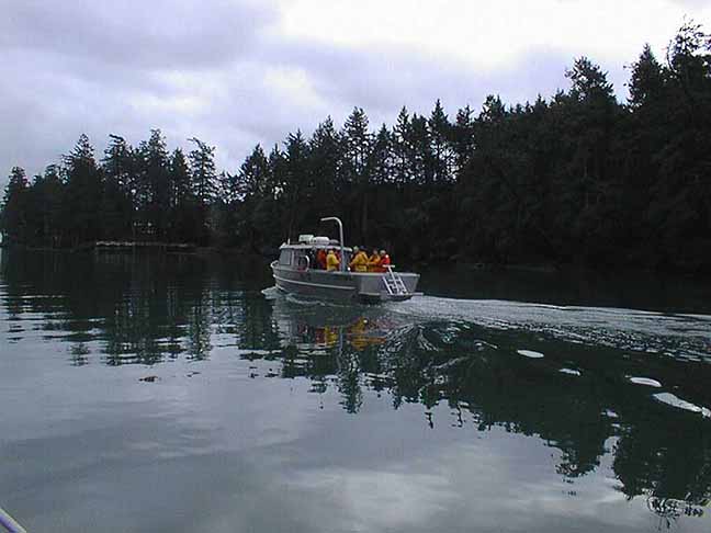
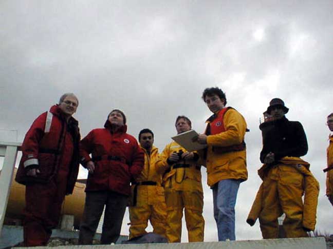
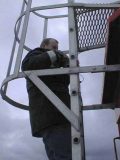
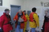
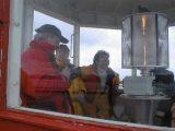
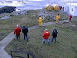
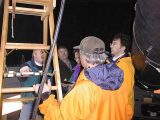
On January 14th, 2000, Tom Bates, Paul Longley, and a Telus representative, along with Angus Macintosh and Scott Nichol, from LGS, came out to Pearson College. After a whirlwind tour of campus from Garry Fletcher, Biology and Marine Science teacher, and Angus Matthews, administration and finance director,  the group headed out to Race Rocks along with several Pearson Students.The group’s main goal for the day was to find sites for the radio or microwave transceivers that would transmit data between the college and Race Rocks.

The transmission of data will be Telus’ contribution to the project. Paul Longley, from pre-sales technical support, and Tom Bates, with microwave engineering, were there to lend their expertise.   LGS’ Aengus Macintosh was acting as project manager, and Scott Nichol was recording the work for the web page the IT firm would be helping to create.

Other options, the tops of local mountains, would require running a ground cable from the site to the college, which would be both time consuming and costly. Clearly, the best option present was to aim for a site just behind Pearson College’s observatory, which was relatively clear of trees and already connected to the internet by a high speed line.

While the group also needed to deal with finding sites and running power to all of the equipment on Race Rocks, their primary concern was the data transmission. In order to get undisturbed transmission they needed a clear line of sight between two stable sites. Any trees, foliage, or other obstructions, or small movements at either end, would break up the transmission. Indeed, even being too close to the water would generate refraction that could disturb data flow.The best solution found was to start from the highest point on Race Rocks, and aim up. From the top of the lighthouse, with the aid of a sighting scope, they took stock of the options: William Head, the closest point to the island, was deemed too low to the water to allow for a clean shot.


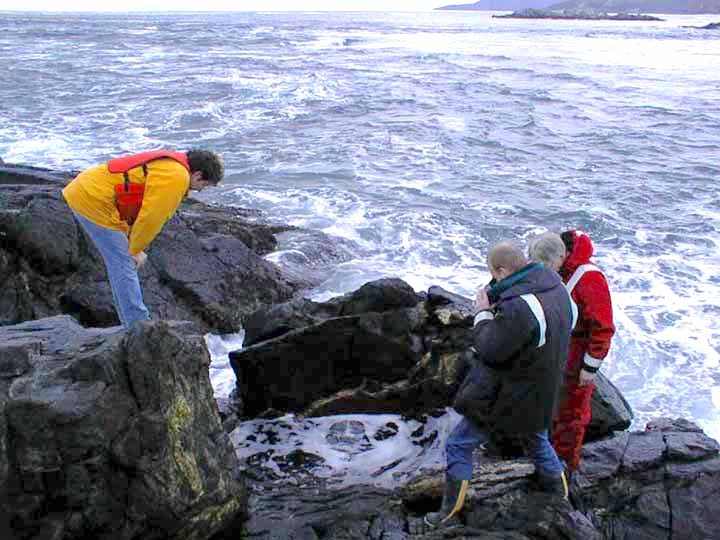
examining the tide pool on the west side

Garry took the group over to the tidepool that has been constructed on the West side of the island.
Plans were to install one small camera underwater in this pool to provide a window to view the emerging life and the frequent surge action .

This tidepool was rearranged and no longer functioning after the hurricane of 2006. Fortunately the underwater camera had not been installed!

=============================================

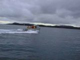
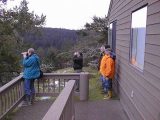
The observatory could be seen from the top of the lighthouse through a gap in the trees. The next question that had to be dealt with was whether any of the taller trees in between would provide an obstruction, and need to be topped. The prospect of gaining permission from the DND to take the tops off of one or two old growth trees on their property was frowned on because of the delays that would undoubtedly ensue. To get an answer, the team decided to take a look at the situation from the other end. A boat ride later, things weren’t much clearer. From within the dome of the observatory, it was very difficult to catch site of Race Rocks, or more importantly, the lighthouse. Despite Garry’s excited, “I see red! ” the mood was skeptical. Stripped black and white, with a red cap, the lighthouse should have stood out, if it was visible. The difficulty catching sight of it suggested that they would either need to be higher up or that a clean shot wasn’t going to be possible.

No one was willing to go ahead with any other part of the project, trying to secure donors and expensive equipment, without being sure that this most fundamental requirement could be met. It was resolved that they would try a test the next day to find out just how high an observatory side tower would need to be, if indeed it was possible at all.

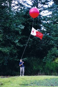
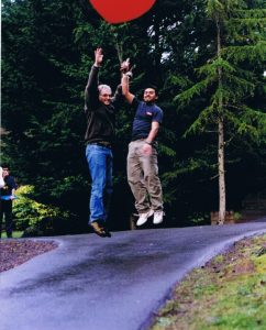
On January 15th, at noon at Pearson College there happened a strange sight. A giant red helium balloon flew high over the college, dancing in the breeze on a long tether tied to a banister at the observatory. While one part of the group headed out to Race Rocks, the other sent up the helium filled balloon.The helium filled balloon. Over radio from the lighthouse, they directed the balloon to be raised higher until they could see it, unmistakably and comfortably above any surrounding trees. The length of the tether, still well within the achievable height for a tower, was proof that a clear line for transmission had been found.

The project is ready to move into actually constructing the tower, setting up the transmission equipment, and obtaining the cameras and sensors. They hope to have transmission established and two cameras up and running by March 11, 2000.

PROCEED TO NEXT UPDATE- FEB 6/2000

LGS Project Management of the Millennium Project

This Project Management was a donation of the LGS group the following .PDF files represent the valuable contribution that this group contributed to ensuring the successful completion of the Project.


1. Project Definition Statement
ganttreportfeb112000

2. January 6, 2000 Gantt Report
PDS01

3. LGS Project Management Methodology
PDS02

4.January 11 Gantt Report
PDS03

The Ecological Niche of Anthopleura elegantissima at Race Rocks”

“The Ecological Niche of
Anthopleura elegantissima at Race Rocks”
by: Santiago Salinas
Candidate number:
0034 – 119
Subject:
Biology   Best Language Spanish

Student , Lester B. Pearson College of the Pacific
Submitted as partial fulfillment for the International Baccalaureate diploma program, January 2000


Abstract
 

As with any other species at Race Rocks, Anthopleura elegantissima is an important member of the ecosystem to which it belongs. By knowing its ecological niche, trends can be analyzed, niche overlapping or other predictions may be made, particularly, for example, if new species are introduced.

The field work consisted of taking three variables (elevation, rock temperature and time underwater) and testing them against number of organisms. Three different populations were selected and a transect containing subsequent quadrats for each was used (a Mann-Whitney test was performed to determine whether or not there is a general trend between the three populations). The variables were selected because they are known to be influential in the determination of the distribution of species. Since the field work took place during only one day due to the limiting factor of low tide level, a good and thorough design was created. The priorities were the elevation of the terrain and the number of organisms per quadrat in view of the fact that the tidal level was constantly altering, making the measurements inaccurate otherwise. The rock temperature was taken once these two sets of values had been gathered from the three locations.

?Since the statistical device suggested that the three populations are organized in the same way, a general description of the ecological niche was given. The species prefer a temperature range of 11-13ƒ C, the ideal elevation span goes from 1.5 to 2.8 meters, thus, it is an inter tidal species, and finally, the preferable time underwater was found to be 5 to 15 hours.

____________________________________________________________

Table of Contents
Introduction

?The Problem ………..?………….9 ?

?Purpose and Background of the Study………9

?Hypothesis …………………………….…..9

?Assumptions …………………………..…..1

?Limitations …………………………….….10

?Definition of Terms ………………………11

Review of Literature and Related Research

?Introduction, Information about the Organism …..13

?The Theory ………………………………….15

?Research Results in Related Areas ……16

Research Design and Procedures

?The Setting and Population of the Stud…18

?Field Work …………………19?

Instruments…………………………21

?Statistical Techniques Used ………22

Analysis of Data

?

Introduction …………………………………….23

?Findings ………………………………………23

Conclusions and Recommendations for Further Study

?

Interpretation and Implications of the Findings……………40

?Recommendations …………………………….42

Appendix

Bibliography

Table of Figures and Tables
Figures

Figure 1. Topographic representation of Race Rocks…….12

Figure 2. Representation of Anthopleura elegantissima and Anthopleura xanthogrammica …………………..14

Figure 3. Location of Populations at Race Rocks…18

Figure 4. Tidal Height graph ………………………. …23

Figure 5. Terrain Gradient graph (Population 1) ……25

Figure 6. Abundance graph (Population 1) …………..26

Figure 7. Elevation against # of Organisms graph (Population 1.27

Figure 8. % of Organisms at different Temperatures graph (Population 1) ……..28

Figure 9. Terrain Gradient graph (Population 2) …30

Figure 10. Abundance graph (Population 2)………31

Figure 11. Elevation against # of Organisms graph (Population 2) 32

Figure 12. % of Organisms at different Temperatures graph (Population 2) ……33

Figure 13. Terrain Gradient graph (Population 3) …….35

Figure 14. Abundance graph (Population 3) ……………36

Figure 15. Elevation against # of Organisms graph (Population 3)…37

Figure 16. % of Organisms at different Temperatures graph (Population 3) ……………………38

Figure 17. Elevation, Temperature and # of Organisms graph (Population 1) …………………40

?Figure 18. Elevation, Temperature and # of Organisms graph (Population 2) …………………41

Figure 19. Elevation, Temperature and # of Organisms graph (Population 3) ………………….42

Tables

Table 1. Data Collection for Population 1 ………24

Table 2. Data Collection for Population 2 ………29

Table 3. Data Collection for Population 3…………34

Acknowledgments
?I would like to express my sincere gratitude to Guillermo Montero and Garry Fletcher for immersing me in the fascinating world of ecology, and also for the support and direction that they provided me. I am also grateful to Sylvia Roach for her invaluable contribution not only to this work but for her constant encouragement.

?Finally, I would like to thank all the organisms at Race Rocks, especially Anthopleura elegantissima, for their patience and understanding of my investigations and for not complaining from my sometimes careless techniques.

Introduction

The Problem: Anthopleura elegantissima (common name: aggregating anemone) plays, along with all other biotic and abiotic components, an important role in the ecosystem to which it belongs. It is a highly valuable member of many food webs and participates in symbiotic relationships with other species. Taking this information into account, it would be useful to know facts about A. elegantissima in order to be able to predict and analyze trends in the ecosystem so as to gain an insightful knowledge about the species and its relation to the ecosystem found at Race Rocks.

Purpose and Background of the Study: To achieve the goals presented, a wide range of proposals were identified, leading to the decision to investigate the ecological niche as a focused and clear plan. The final design involved testing three populations at different locations of the island with the purpose of determining the preferred range of abiotic conditions for A. elegantissima. Four very significant variables were examined, all of them intimately related with intertidal zonation. These four variables were: the slope of the gradient, the tidal height, the time covered by sea water and the rock temperature. Carrying out the field work in three different sites allowed room for generalized conclusions about the species to be made.

Hypothesis: A null hypothesis for the Mann-Whitney test was formulated: “the three different locations are not inter-related and the similarities that may occur are merely coincidental.” If rejected, some conjectures about the species had to be formed. Given that Anthopleura elegantissima is a low inter tidal species, its range of positioning would not be between 1 to 3 meters. A hypothesis was made based on the fact that sea water is generally at about 10ƒ C, thus the rock temperature was not expected to be similar to this.

Assumptions: One of the major assumptions made was that the tide tables for Victoria, British Columbia, Canada are the same as these for Race Rocks. In theory this may not be true since Race Rocks is located approximately 10 km. away from Victoria. Therefore, there might exist a slight difference in tidal heights between the two zones.

Limitations: The entire experiment and data collection was done on the 27th of October, 1999, due to the limiting factor of relative low tides occurring in day-light hours. Hence the experiment could not be repeated on another day. Therefore, the research reveals the ecological niche of Anthopleura elegantissima at a fixed point in time and not the variations or changes in its distribution over a period of time. Furthermore, based on these results, the general ecological niche of the species cannot be concluded since all the data was gathered in a specific place, Race Rocks, which is a distinct site due to its location.

Another major limitation is that the “ecological niche” is an abstract term and therefore, the ecological niche of a species can never be fully represented. What was done in this case was to narrow the aspects to be considered and try to work with them by relating each factor to the others to acquire an approximation of the ecological niche. In this essay, four abiotic components were measured in order to obtain an insight to the ecological niche of Anthopleura elegantissima.

Definition of Terms: A number of terms should be defined at this point in order to ensure a clear understanding of this essay. One of these terms is population, which is defined as: all members of a species living in a particular area and making up one breeding group (Kucera, 1978). This is of particular importance since a similar species, Anthopleura xanthogrammica, may be found on the island, a phenomenon which would cause some distortions in the results if they are counted as Anthopleura elegantissima. Tides – the gravitational effects of the sun and moon on the oceans of the earth – are also a fundamental pivot in intertidal life. Tides along the Pacific coast of North America are of the mixed semidiurnal type; that is, there is a pronounced difference between the levels to which two successive low tides fall, and a lesser, but still apparent, difference between the levels reached by two successive high tides (Carefoot, 1977). Lastly, the most important term to be defined is ecological niche. The niche of a population or species is its functional role in an ecosystem. Using a human analogy, the niche is the species’ profession or way of life whereas the habitat is where this way of life is carried on — its address. The way a population responds to the various characteristics of its habitat is part of this population’s way of life and, therefore, of its niche. Hutchinson was the first to formally quantify the niche concept in terms of geometric space. The level of activity describes the ability of the individual to exploit the resources in a given level of each environmental factor (Odum, 1963). Then the niche space occupied by the species is the 3-dimensional space actually occupied by all individuals (Rickleffs, 1996). An empirical model (Box and Draper, 1989) can be obtained by the empirical determination of niche occupancy (number of individuals, in this case) in terms of n environmental variables (slope, tidal height, time covered and rock temperature).

Review of Literature and Related Research

Introduction, Information about the Organism: The field work was conducted at Race Rocks, Southern Vancouver Island, British Columbia, Canada. This area was chosen for ecological reserve status because of its unique richness and diversity of marine life. Race Rocks is ideally located to receive a constant supply of plankton swept past by almost continuous strong currents (up to 7 knots) . This provides nourishment for a complex group of underwater organisms.

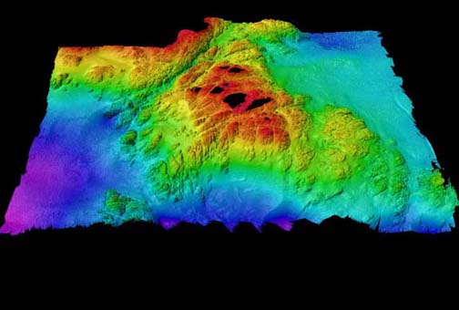
Figure 1. This image is a view from the South of Race Rocks looking Northward. Colors toward the blue scale are representing depths of almost 100 meters. (3d capture of entire area from south – 1x magnification – 3 x vertical exaggeration).

One of the many organisms found at Race Rocks are sea anemones. Sea anemones belong to the phylum known as the Cnidaria, from the cnida or stinging cells that are present in this major group of animals that also include corals, jellyfish, hydroids, medusae, and sea fans. Sea anemones, corals and their allies form the class know as the Anthozoa. Anthopleura elegantissima (Phylum Cnidaria, Class Anthozoa, Subclass Zoantharia, Order Actiniatia, Family Actiniidae) is abundant on rock faces or boulders, in tide pools or crevices, on wharf pilings, singly or in dense aggregations (Smith and Carlton, 1975). It is a species characteristic of middle intertidal zone of semi protected rocky shores of both bays and outer coast from Alaska to Baja California. Aggregating individuals do not exceed 6 centimeters in column diameter and 8 centimeters across the tentacular crown. The column is light green to white, and twice as long as wide when extended, with longitudinal rows of adhesive tubercles (verrucae) often bearing attached debris (Carefoot, 1977). The species presents numerous short tentacles, in five or more cycles, which are variously colored. Anthopleura elegantissima reproduces both sexually and asexually. In sexual reproduction, ova are present as early as February and grow steadily until their release in July; the ovarian is then resorbed and new eggs do not appear until the following February. Sperm are released through the summer. The asexual reproduction occurs by longitudinal fission. This process results in aggregations or clones of anemones pressed together in concentrations of several hundred per square meter. Anthopleura elegantissima feeds on copepods, isopods, amphipods, and other small animals that contact the tentacles. On the other hand, it is preyed upon by the nudibranch Aeolidia papillosa, which usually attacks the column, by the snail Epitonium tinctum, which attacks the tips of the tentacles, and by sea stars such as Dermasterias imbricata that can engulf an entire small anemone. Moreover, in some anemones, small pink amphipods, Allogaussia recondita, make a home in the gastro vascular cavity (Carefoot, 1977).

Figure 2. Schematic representation of Anthopleura elegantissima and Anthopleura xanthogrammica, the two major sea anemones found at Race Rocks.

The theory: In 1957, G. E. Hutchinson defined the niche concept formally. One could describe the activity range along every dimension of the environment. Physical and chemical factors such as temperature, humidity, salinity, and oxygen concentration, as well as biological factors such as prey species and resting background against which an individual may escape of predators, could be determined. Each of these dimensions could be thought of as one of the n-dimensions in space. Visualizing a space with more than three dimensions is difficult, thus the concept of the n-dimensional niche is an abstraction. We may, however, deal with multi-dimensional concepts mathematically and statistically, depicting their essence by physical or graphical representations in three or fewer dimensions. Moreover, Ricklefs notes that “… for example, a graph relating biological activity to a single environmental gradient represents the distribution of a species’ activity along one niche dimension. The level of activity, whether oxygen metabolism as a function of temperature or consumption rate as function of prey size, conveys the ability of an individual to exploit resources in a particular part of the niche space and, conversely, the degree to which the environment can support the population of that species. In two dimensions the individuals niche may be depicted as a hill with contours representing the various levels of biological activity. In three dimensions, we must think of a cloud in space whose density conveys niche utilization. Beyond three the mind boggles.”

(Ed note: See exercise on Ecological niche)

To be more precise, it should be recognized that there are three different definitions for the term niche. The first one (also known as “niche as community function”) comes from Elton (1927) defining it as the animal’s place in the biotic environment, its relation to food and enemies. The second definition is called “niche in the species” and reveals that a specific set of capabilities for extracting resources, for surviving hazard, and for competing, coupled with a corresponding set of needs (Colinvaux, 1982). The most used and known is the one defined by Hutchinson, which was explained previously. 

Research Results in Related Areas: Even though only one research paper was found containing information about Anthopleura elegantissima at Race Rocks, many investigations have been carried out with Anthopleura elegantissima and its physiology. The paper obtained on Anthopleura elegantissima at Race Rocks (Zahid, 1987) tries to detail the distribution of the species in one crack by two statistical methods (Plotless and Poisson techniques). It is concluded that A. elegantissima is an intertidal organism showing a clumped distribution. The clonal form, being lower mid-intertidal is exposed to sunlight and air much more than the solitary form in the sub-tidal zone. Hence, the clumped distribution is very useful and is also an important factor in reducing desiccation and water loss, as clumping reduces the surface area exposed to light.

Research Design and Procedures

The Setting and Population of the Study: The field work was designed to take place in three different locations of Race Rocks (see Figure 4), in order to gain a more detailed examination of the ecological niche of Anthopleura elegantissima in this island. Another reason for doing so was well explained by Odum: “It is also true that the same species may function differently —that is, occupy different niches- in different habitats or geographical regions.” The three places exhibit different environmental conditions and, therefore, the species may experience changes in its distribution. These changes could be current flow (which is in and of itself a major contributor to tidal life), light exposure, and even different rock composition.

A hazardous inconvenience that had to be overcome before doing the field work was to be able to distinguish among the two major types of sea anemones at Race Rocks, Anthopleura elegantissima and Anthopleura xanthogrammica. In order to achieve this, a key book was consulted. In the book, the distinctive characteristics between the two are described (see Appendix.)

 
Figure 3. Hand-made representation of Race Rocks showing the location of the three populations, the lighthouse and the docks.

Field Work: The complete field work took place on the 27th of October, 1999 due to the limiting factor of low tide level. The priorities were the elevation of the terrain and the number of organisms per quadrat in view of the fact that the tidal level was constantly altering, making the measurements inaccurate otherwise. The rock temperature was taken once these two sets of values had been gathered from the three locations. For the sake of help, a line transect was set in each crack to make the data collection uncomplicated and feasible.

Elevation: With the aim of measuring the elevation of the terrain for each population, a rudimentary, home-made apparatus was created. Due to the fact that the topography of the shore is extremely irregular at Race Rocks, it is not possible to assume that the elevation is a straight line. Thus, to have a detailed insight of Anthopleura elegantissima —or any other intertidal organism- at Race Rocks, an imperative factor to be considered is elevation. To approach this, the first action taken was to delimit the transect (generally a straight line along which observations are made in a systematic fashion) and the quadrats (starting from where the tidal level equals 0 meter). Since there was not a zero meter tide predicted, it was decided to start at 0945 approximately —tidal height equal to 2- and calculate the zero tide level. To accomplish the task, a two meter stick was used perpendicular to the sea water since tidal height is a vertical measure of water. Following this, a 4 meter stick was put where the tidal level equals 0 meter -quadrat number 15- (perpendicular to the sea water) and, with the help of a rope, a triangle was formed between the stick, the rope and the last quadrat —number 1. Once the triangle was finished, the elevation existing between quadrat number 1 and number 15 is known by the distance in the stick from the land to the conjuncture of it and the rope (for example, 3.9 in the first population). The subsequent measurements were much easier to carry since only a meter stick and a measuring tape were needed. Starting from quadrat number 1, a meter was measured with the measuring tape along the land. Then, the meter stick was put in such a manner that it formed a 90ƒ angle with the top of the quadrat, giving a number (0.3 in the first population). Therefore, 3.1 minus 0.3 equals 2.6, the elevation for quadrat number 2). So on and so forth the procedure was repeated until quadrat number 15 was reached.

Number of organisms: A very important feature involving the number of organisms per quadrat is the quadrat’s size. It was proven by Grey-Smith (1952) that the size of a quadrat could actually determine some erroneous conclusions in a population by using a series of progressively larger quadrats to measure the distribution in an artificial situation in which individuals were represented by colored disks. A reasonably good size for the quadrats was estimated to be 0.5 by 0.5 meters, given personal observation. Once the quadrats were sorted out, the counting took place. Only if more than 75 % of the organism was inside the quadrat was it counted. A difficult aspect of the counting was to differentiate individuals from the same group clone or aggregation. This difficulty was expected since the clones are held together very tightly and because at this time of the year young anemones are developing their bodies (as fertilization occurs during summer).

Rock temperature: This process was relatively simple compared to the previous two. It consisted of using the thermometer in small crevices in rocks —for each quadrat- in order to get the rock temperature.

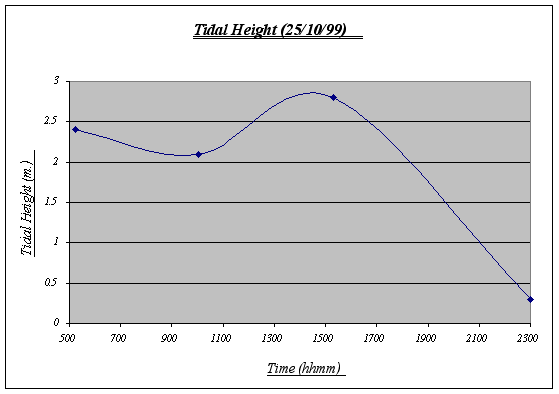
?Time underwater: Aided by the tide table for the day (starting at 0500 and finishing at 2300), it is possible to calculate how much time a certain elevation is exposed to sea water. Assume that it is desirable to know the underwater time of a quadrat at 2.5. Then, we trace a line at 2.5 and the area under the curve will indicate the time that quadrat was covered by water.

Instruments Used: A simple technological apparatus was used for the field work. A measuring tape, a meter stick, a four meter stick, the tide tables for Victoria, BC, a thermometer, and a rope were all the required instruments.

Statistical Techniques Used: The technique used to verify that the distribution of the species was not random or by chance was the Mann-Whitney test. This non-parametric tool (meaning there are no specific distributional assumptions required) is sometimes called Wilcoxon test or rank sum test. This test relies on a special kind of transformation that replaces each observation by its rank in the combined sample. The purpose of this is to transform the data to a scale that eliminates the importance of the population distribution altogether (Ramsey and Schafer, 1997). In order to make it easier and more accurate, a web-page (VassarStats) was utilized to perform the calculations and the statistics values.


Analysis of Data

Introduction: The data will be presented by population and not by factor. This is aimed to help the understanding of the ecological niche of Anthopleura elegantissima at Race Rocks in a detailed and comprehensible fashion. Three separate populations were examined on different parts of the island The populations are numbered (1, 2 and 3) referring to a certain strip (see Figure 4.)

Findings: The Mann-Whitney test was used to determine whether or not there is a general trend between the three populations. Two populations were tested at a time, therefore, three runs of the test were conducted using the number of organisms as the variable to be ranked. Using VassarStats, an U value was calculated: 140.5 for populations 1 and 2, 96.5 for populations 1 and 3, and 44 for populations 2 and 3. These U values were then checked in the significance levels table:

n
5 per cent
1 per cent
15
185
170


By this, it is possible to conclude that, although it is impossible to be absolutely certain that the different is not due to chance, the probability is sufficiently small for it to be considered negligible. Thus, the null hypothesis can be rejected and assume that there are similarities among the three populations. Bearing that in mind, the variables should now be tested to determine the ecological niche of Anthopleura elegantissima at Race Rocks.

?Tidal Height:

Figure 4.

The variations of the tidal height of the day are normal and reflect the constant water movement that take place in the ocean affecting inter tidal life. Based on this chart, the underwater time will be calculated. Note that the chart begins at 0500 and ends at 2300 (therefore, total time underwater = 18:00).

Population # 1:

Quadrat #
Elevation (m.)
Rock Temperature (ƒ C)
# of Organisms
Time Underwater
1
3.9
12
0
00:00
2
3.6
12
0
00:00
3
3.7
12
0
00:00
4
3.4
13
5
00:00
5
3.2
12
10
00:00
6
3.0
12
21
00:00
7
2.9
11
32
00:00
8
2.5
12
56
04:30
9
2.4
12
68
05:15
10
2.1
13
55
07:55
11
1.7
13
76
14:10
12
1.2
12
45
15:30
13
0.9
12
25
16:15
14
0.6
12
18
17:05
15
0.0
12
21
18:00
Mean Temp. 12.133

Table 1.
 
Figure 5.

The terrain gradient for population number 1 is the typical slope and is also the most regular among the three. It has a steep drop at the end (quadrat # 15) where it meets the sea water at 0 m. (tidal level). This gradient features some small tide pools and is sometimes covered by kelp beds. By personal observations, I could say that it is the strip with the highest level of species diversity on it.

Figure 6.

Even though this is not the most abundant population (432 individuals), it features the largest number of individuals per quadrat (76) and has an extremely large number of Anthopleura elegantissima at a certain level of the gradient. It should also be noted that no individuals were found in the first three quadrats and there were not many before quadrat 6. The number of organisms was measured in quadrats of 0.25 square meters.

Figure 7.
 

This graph clearly shows the relationship between elevation and number of organisms. It is easy to recognize that the preferred place for Anthopleura elegantissima is around 1.2 to 2.5 meters, a fact that will be very useful when making conjectures about its niche. The drop of abundance at 2.1 is only a local anomaly. At high heights (3.9, 3.6, etc.) there were no organisms present while at low heights there were some (however not very many).

Figure 8. (Note that 1 symbolizes 11ƒ C, 2 symbolizes 12ƒ C, and 3, 13ƒ C)
 

Despite the fact that a correlation could not be found between rock temperature and elevation or tidal height, an important feature was discovered, this being the relationship involving surface rock temperature and abundance. It was discovered that Anthopleura elegantissima prefers a rock temperature of 11, 12 or 13 because of the fact that these were the only temperatures found on the rocks (higher elevations were found to be warmer and A. elegantissima apparently does not favor such conditions).

Population # 2:

Quadrat #
Elevation (m.)
Rock Temperature
(ƒ C)
# of Organisms
Time Underwater
1
3.8
12
0
00:00
2
3.7
13
2
00:00
3
3.4
12
24
00:00
4
3.3
12
33
00:00
5
3.1
12
50
00:00
6
2.8
11
47
00:00
7
2.5
11
58
04:30
8
2.4
11
61
05:15
9
2.1
12
62
07:55
10
1.6
12
46
14:20
11
1.2
12
40
15:30
12
1.3
13
34
15:15
13
0.8
11
26
16:30
14
0.3
12
29
18:00
15
0.0
12
23
18:00
Mean Temp. 11.866

Table 2.
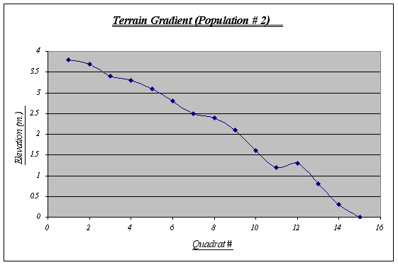
Figure 9.

This gradient features a large tide pool at 1.25 meters level. In it, a whole new ecosystem is found due to different climatic conditions, therefore, it may create some distortions with the number of Anthopleura elegantissima expected. A steep fall at the end should also be noted as a probable cause for the distribution of the species.
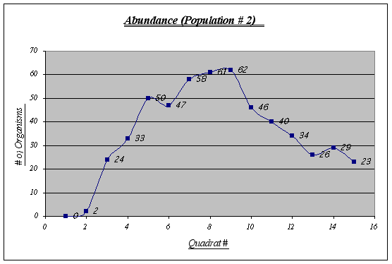
Figure 10.

In this population some irregularities are shown. Quadrats 6 and 13, for example, are not quite as expected. The virtual absence of organisms in quadrat 1 and 2 has to be considered as well. Overall, an inverted u-shaped curve could be distinguished.
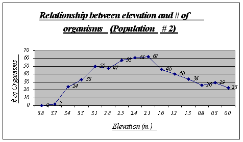
Figure 11.

Again, the same trend as in population 1 is presented. A major distribution is seen at 2.1 to 2.8 meters and none or very few organisms were found at high elevations. On the other hand, a large number of the species was encountered at very low elevations
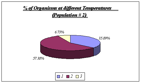
 

Figure 12.

These results reinforce the idea that Anthopleura elegantissima prefer a range of temperatures of 11-13ƒ C. No further analysis could be made since it is unlikely that a distinction could be drawn using greater detail such as degree by degree. On the other hand, at temperatures significantly different from the range above, the species will not be found.

?

Population # 3:

Quadrat #
Elevation (m.)
Rock Temperature (ƒ C)
# of Organisms
Time Underwater
1
3.6
13
4
00:00
2
3.3
13
11
00:00
3
3.2
13
20
00:00
4
2.9
12
31
00:00
5
2.7
12
33
00:00
6
2.2
12
25
09:45
7
2.2
11
28
09:45
8
1.9
12
22
13:30
9
1.8
12
16
13:50
10
1.4
11
19
15:00
11
1.0
12
23
16:00
12
0.9
12
15
16:15
13
0.6
12
12
17:05
14
0.4
12
10
17:30
15
0.0
12
10
18:00
Mean Temp. 12.066

Table 3.
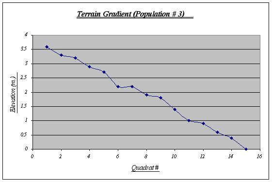
Figure 13.
 

This gradient was the most irregular of the three, featuring ups and downs from the first to the last quadrat. A fact that seems rather curious is that on top of this strip sea lions lie down to rest quite frequently whereas this does not happen in the other two strips, probably because this gradient starts from a very plain, big rock. Kelp beds are observed floating on water and algae is seen at higher elevations.
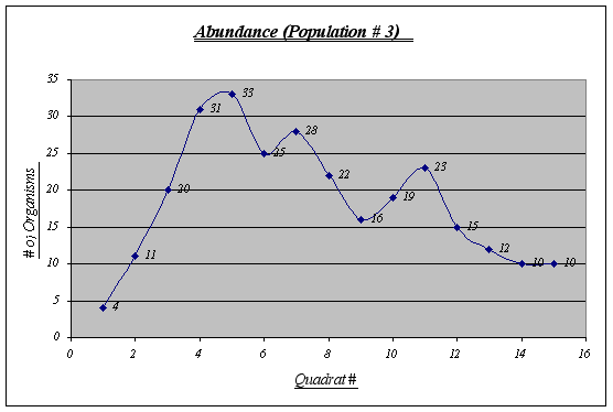
Figure 14.

Although this graph does not show a perfect inverted u form, a general trend is seen. This population is the less abundant of the three and shows some irregularities in the middle quadrats.
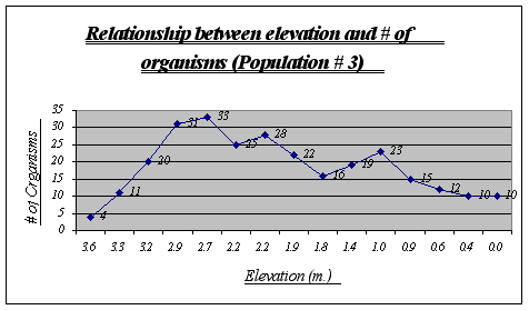
Figure 15.

Apparently, more organisms prefer a range of 2.9 to 2.2 meters in this gradient. Some animals were found at 0.0 meters but not many were seen at higher heights. Two major drops, at 2.2 and 1.8 meters, can be explained due to overpopulation of other species in those two tide pools.
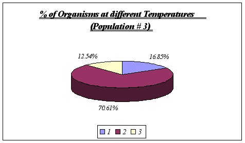
Figure 16.

Once again, no other temperature ranges were found, leading to the conclusion that Anthopleura elegantissima does prefer temperatures of 11deg C to 13deg  C.

Conclusions and Recommendations for Further Study

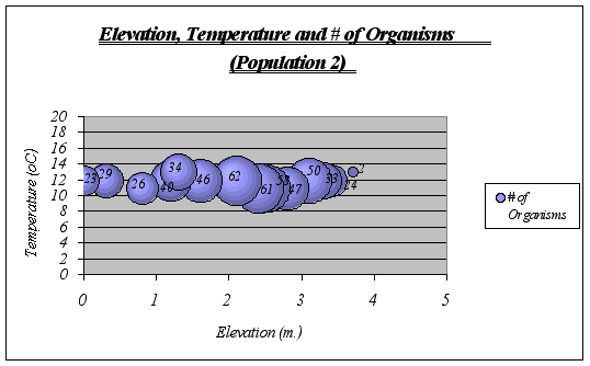
Interpretation and Implications of the Findings: After looking at the graphs, general descriptions of the ecological niche of A. elegantissima could be made:

ideal temperature for the species is a range of 11-13ƒ C because at higher or lower temperatures, the number of organisms decrease significantly. The null hypothesis is then rejected.

 Idyllic elevation goes from 1.5 to 2.8 meters. Once again, the null hypothesis is rejected.

Since time underwater is a function of elevation, it was not considered on graphs. However, the preferable time underwater for Anthopleura elegantissima was found to be 5 to 15 hours approximately (out of 18 hs.)

A clear description of the ecological niche dimensions is observed in the graphs below. The larger bubbles represent the portion of the space that the species prefers:
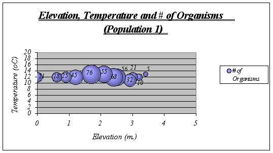
 

Figure 17
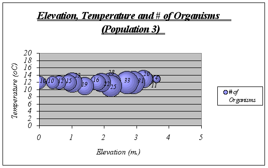
Figure 18
Figure 19.
 

Recommendations: If a thorough understanding of the ecological niche of Anthopleura elegantissima is desired, these and more variables should be tested to obtain a more profound and detailed approximation. Also, by determining ecological niches of other species such as Anthopleura xanthogrammica and comparing them, it is possible to predict niche overlapping, which is very likely to lead to a constant competition and aggressive behavior of the species. Moreover, it could be used to predict changes in the ecosystem if introduced species are brought. The documentation of data like this provides an invaluable record for establishing baseline distributions of organisms. Scientists are often required to monitor anthropogenic changes in sensitive marine environments. Similar niche patterns could be done on the other key invertebrates of the inter tidal and sub-tidal zone at Race Rocks, for example black leather chitons, limpets, abalone and various species of algae.

Appendix
This appendix presents the dichotomous key for Anthopleura elegantissima and Anthopleura xanthogrammica.

“Column green to white; tubercles usually in distinct longitudinal rows; tentacles with pink tips; height up to about 5 cm; often in aggregating masses, and frequently buried by sand covering rocks to which they are attached Anthopleura elegantissima. ~~ Column green or olive green; tubercles usually not in distinct longitudinal rows; tentacles uniform in color and not pink-tipped; height regularly exceeding 5 cm; solitary and not often buried in sand Anthopleura xanthogrammica.”

Boughey, A.S. 1968. “Ecology of populations.” The Macmillan Company, New York.
Buschsbaum, R., Buschsbaum, M., Pearse, J, and Pearse, V. 1987. “Animals without backbones.” University of Chicago Press, Chicago, Illinois.

Carefoot, T. 1977. “Pacific seashores.” J.J. Douglas, Vancouver, BC, Canada.?

Colinvaux, P. 1986. “Ecology.” John Wiley & Sons, United States of America.

Francis, L. 1973. “Clone specific segregation in the sea anemone Anthopleura elegantissima.” Biological bulletin. 144, 64-72.

Francis, L. 1973. “Intraspecific and its effects on the distribution of Anthopleura elegantissima and some related sea anemones.” Biological bulletin. 144, 73-92.

Kozloff, E.N. 1974. “Keys to marine invertebrates of Puget Sound, the San Juan Archipelago, and adjacent regions.” University of Washington Press, Washington State.

Kozloff, E.N. 1993. “Seashore life of the Northern Pacific Coast.” University of Washington Press, Seattle, Washington State.

?Kucera, C. L. 1978. “The challenge of ecology.” The C. V. Mosby Company, Saint Louis.

Lewis, J.P. 1995. “La biosfera y sus ecosistemas: una introducción a la ecología.” Ecosur, Rosario, Argentina.

Odum, E. P. 1963. “Ecology.” Holt, Rinehart and Winston, United State of America.

Odum, E.P. 1989. “Ecology and our endangered life-support systems.” Sinauer, Sunderland, Massachusetts.

Pianka, E. R. 1986. “Ecology and natural history of desert lizards.” Princeton University Press, Princeton, NJ.

Smith, R.I., and Carlton, J.T. 1975. “Intertidal invertebrates of the Central California Coast.” University of California Press, Los Angeles, California.

Zahid, M. 1987. “Distribution of Anthopleura elegantissima.” Extended Essay for the International Baccalaureate.

GO to the Ecological Monitoring Site 

Agenda for the RR MPA Advisory Board Meeting, January 5, 2000

Purpose:

Second meeting of the Race Rocks Advisory Board.

Participants:

Doug Biffard – BC ParksCheryl Borris – Friends of Ecological Reserves

Erin Bradley — Dive Community

Howard Breen – Georgia Strait Alliance

Garry Fletcher – Lester B. Pearson College

Kelly Francis – Fisheries and Oceans Canada

Duane Freeman – Department of National Defence

Gordon Hanson – Coast Salish Sea Council

Dan Kukat — Sport Fish Advisory Board

Lieutenant Commander Bill Laing – Department of National Defence (DND)

Angus Matthews -Lester B. Pearson College

Sean Moore – Marina Operators

Jim Morris – BC Parks

Marc Pakenham – Fisheries and Oceans Canada

Dr. John Pringle – Fisheries and Oceans Canada

Tom Sampson – Coast Salish Sea Council

Keith Symington – Canadian Parks and Wilderness Society (CPAWS)

Dr. Anita Voss

Kevin Walker?- Northwest Whale Watchers Association

Scott Wallace

Observers

Sean MacConnachie – Fisheries and Oceans Canada

Paul Preston – Fisheries and Oceans Canada

Jenny Sparkes – Parks Canada

Wendy Szanislow – Parks Canada

*************************************************************

Agenda

  1. Purpose of Meeting
  2. Draft Terms of Reference
  3. Consensus decision making
  4. MPA boundaries
  5. Draft Management Plans
  6. Updates from meetings/consultations
  7. Other business

Race Rocks MPA Advisory Board meeting 2

RACE ROCKS ADVISORY BOARD MEETING # 2

DRAFT MINUTES

11h00 – 15h30, JANUARY 5, 2000

LESTER B. PEARSON COLLEGE, VICTORIA


Participants: Howard Breen – Georgia Strait Alliance

Regrets:Doug Biffard – BC Parks

Observers:Sean MacConnachie – Fisheries and Oceans Canada

***************************************

INTRODUCTIONS

  • The meeting began with a roundtable introduction of the participants.

TERMS OF REFERENCE DISCUSSION (TOR)

  • Marc Pakenham read the draft Terms of Reference and indicated that it is a rough draft and still requires the input from the RRAB and TOR sub-committee. Comments from Jenny Sparkes and Gord Hansen have been received. Jenny Sparkes wasn’t clear what the RRAB outcomes were supposed to be from the TOR and has suggestions for each point.
  • Angus Matthews suggests that the TOR are quite adequate and don’t need revision. He is keen to move on with rest of process.
  • Jenny Sparkes indicated that it is important in this process that people are clear of the game rules from the outset.
  • Howard Breen agreed that the TOR is good and need to move forward with this process.
  • Roundtable review of the TOR.
  • Anita Voss inquired if there was a time frame for the goals set out in the TOR. Marc Pakenham replied that the goal was to have the recommendations completed by March 10. Kelly Francis indicated that the future evolution of the RRAB was not entirely clear.
  • Angus Matthews re-iterated the importance of moving forward with this process. Pearson College is currently funding the caretaker and bearing responsibility for the operating costs at Race Rocks. They are unable to raise further funds until this site is designated. He suggested that governments have to understand that private funds are driving this process.
  • Howard Breen suggested that in regards to the First Nations paragraph it is important to identify which First Nations are being affected by this process (i.e. T’souke, Esquimalt, Beecher Bay, and Songhees First Nations).
  • Tom Sampson indicated that it is important to have First Nations mentioned in this process being that it may be a template for future processes. He suggested that First Nations do not need to be identified directly because the First Nations will know which ones are directly involved.
  • Jim Morris would like to see it spelled out in the TOR that Race Rocks is an Ecological Reserve and that the establishment of a MPA will enhance and/ or preserve the current status.
  • Angus Matthews believes consensus is where everybody is reasonably content and walks away from the table satisfied. Being that this is a pilot process the consensus “bar” should be set higher than is stated in the draft TOR. Marc Pakenham suggested that recommendations will probably not please everyone 100%, but this process will respect and provide the opportunity to indicate their views.
  • Howard Breen suggested that if the RRAB could endorse the recommendations 100% they would be accepted much more broadly throughout the community.
  • Keith Symmington asked to have these comments read into the minutes: “CPAWS supports the establishment of a ‘protocol agreement’ between the Province and Fisheries and Oceans Canada, as well as the recognition of the Constitutional and treaty rights of First Nations and their interest in a cooperative management regime, within the Terms of Reference“.
  • Marc Pakenham asked the RRAB members to send comments to him by Friday January 7, 2000. He will synthesize the comments and have a conference call on Tuesday Jan 11 with the TOR sub-committee and will have a revision out to RRAB board members by Tuesday afternoon.

ECOSYSTEM OVERVIEW PRESENTATION

  • Brian Smiley introduced himself and the purpose of the presentation including:
    • The background of ecosystem overview;
    • the MS Access database created by the College; and
    • Cindy Wright’s contract to synthesize the ecosystem overview into a written report format which outlines major gaps in our current knowledge and provides general recommendations on future research. The report does not address socio-economic information, nor does it provide strategies or actions for implementing research recommendations.
  • Cindy Wright described the report and it was based on a similar report prepared for Sable Gully. It is oriented for aquatic issues.
  • Outstanding physical features at Race Rocks:
    • High velocity currents up to 6 knots. High velocity currents create turbulence which mixes water column, prevents stratification, delivers high nutrients, and high oxygen content to support benthic community;
    • High nutrients and rocky substrate attract lots of animals and high larval recruitment;
    • Algal biomass: 110ha X 67 metric tonnes/ ha = 7370 metric tonnes of algae/year;
    • 130 known species/genera of phytoplankton and 100 zooplankton;
    • Over 200 species/genera of invertebrates. High abundance and high diversity including a strong population of threatened abalone;
    • Critical habitat for species of rockfish, lingcod, and kelp greenling. Not knowledgeable of fish distribution through lifecycle. About 95 known species of near-shore fish;
    • Marine mammals: Haul-out site/ rafting for pinnipeds. Predominantly used by harbour seals for all lifestages. 2nd largest seal haul-out in Canadian waters of Georgia Basin. At times can represent 20% of seal population in area. Reports of up to 1000 seals reported at Race Rocks. Reported as a high use area for transient Orca;
    • Birds: 4-5 species use Race Rocks as a nesting site. 23% of pelagic cormorants in eastern Juan de Fuca are at Race Rocks; and
    • Traditional Ecological knowledge. Pearson college working with First Nations and fisherman to acquire knowledge.
  • Marc Pakenham asked if we could have this presentation to circulate. Brian Smiley indicated that he would make it available, but that it is a high-grade of the draft report. Hopes to keep this document and databases as a living document to be updated in future.
  • Howard Breen inquired if the Ecosystem Overview supported an extension of the boundaries of the ecological reserve. Brian Smiley suggested that we now have a baseline to go from; therefore depending on which objective is focused upon will determine the requirements of the boundaries (e.g. If the objective is to protect a nesting area, the boundaries are probably sufficient. If the objective is to protect foraging sights the boundaries may be too small).
  • Garry Fletcher suggested that the existing boundary would work very well if everybody abided by it. He expressed concerns that the annual changes of animal’s behaviour may put them outside the boundaries. He indicated that he would hate at this stage for boundary discussions to prevent decisions being made. He suggested that flexibility needs to be maintained as information is acquired.

LUNCH

BOUNDARY DISCUSSION

  • Marc Pakenham reviewed the boundary options that have been presented to stakeholders. He described enforcement problems with existing boundaries in regards to depth in meters. Feedback to date supports mostly option 2, the angularized boundaries of the ER. This option does not reduce the size of the ecological reserve, but does make it easier to describe by legal terms and is easier for mariners. The boundaries could possibly use buoys or sight markers. Option 2 is approximately 10% larger than existing ER boundaries. Option three has a 100 metre buffer zone around angularized option 2.
  • Howard Breen suggested that the Georgia Strait Alliance generally support the concept of buffer zones. With this particular case it may be feasible to increase seabed protection, but not reduce pelagic fishing opportunities outside existing boundaries.
  • Brian Smiley inquired if it was possible to extend the boundary along the bottom to protect the important habitat that some threatened species use during part of the year.
  • Sean Moore indicated that the SFAB fully endorses the protection of rockfish within the existing area, but is looking for the continuation of fishing opportunities for transient species (e.g. halibut and salmon) within the existing reserve.
  • Angus Matthews reminded the group that the objective for a MPA in general is not only to protect species and habitat but to increase research and public education. Overlaying existing boundaries of MPA with ER would be easier politically. Problems with the option 2 lie on south west corner of ecological reserve where there are two halibut fishing spots. Angus Matthews suggested that the SFAB might agree to a no-take in the existing area if the boundaries did not increase. Other issues to take into consideration include flying tourism. He suggests that a small footprint would be a more effective to designate and further rockfish closures are a separate fisheries issues.
  • Jim Morris indicated that this MPA cannot solve all problems today. The management plan could make a recommendation for a future increase in the size of the MPA or possibly a creation of another ER or increase in the size of the ER.
  • Tom Sampson indicated that we should be aware that there are existing Supreme Court decisions that grant First Nations absolute rights to the fishery resources as well as treaty rights that supersede any new rules. It is important to recognize that if you only protect / manage the shoreline you’re ignoring the natural spawning process and interaction between the shallow and deepwater. Nature has provided existing patterns that we are ignoring, the pattern or options that we are promoting do not comply to these existing patterns.
  • Anton Roberts inquired if this area is going to be an absolute “no-go zone”. Kelly Francis described minimum levels of protection under Pacific MPA strategy and that this process will define the levels of protection for Race Rocks. It is anticipated that Race Rocks MPA marine components will continue to offer public access under some guidelines or regulatory authority.
  • Howard Breen indicated that although the Georgia Strait Alliance supports a larger area, they would not block consensus if the RRAB recommends maintaining the existing boundaries with an angularized version. Their larger concern is that the energy and resources that have gone into the pilots will not be carried on to future candidates.
  • Marc Pakenham indicated that enforcement is a major issue. He felt that stakeholders would support a relatively small MPAs if they were properly enforced.
  • Cindy Wright asked what level of protection the buffer zone would offer. Marc Pakenham responded that the buffer zone would offer a different level of protection.
  • Rupert Gale suggested that the angularized areas of option 2 could be the buffer zone.
  • Angus Matthews suggested that angularized version isn’t critical for habitat. For managing the area radar would be effective in managing boaters that enter into the area.
  • Anita Voss suggested that invertebrates contribute significant amounts of biomass via their larvae into the environment.
  • Jim Morris suggested that the important part of this process is to inform the people of what they can and cannot do in the area. Suggests that during the ER consultation consensus was essentially reached, and changes in the area would not be effective.
  • Garry Fletcher felt that there were large safety concerns with using anchors and buoys in the area.
  • Brian Smiley indicated that any MPA will have to be Gazetted and described legally. Therefore a bathymetric definition of the area would not be an effective method to enforce. He suggests that using a GPS enforceable definition would be a lot more effective in monitoring and compliance.
  • Howard Breen suggested that the bathymetry for this area may be the best defined for the whole coast, but as a precedent, it is not an effective system because future MPAs will not be have this level of bathymetric observation.
  • Tom Sampson suggests that the MPA could be in place for a certain amount of time and then re-evaluated. He described the process of restoration of Goldstream river and the resolution of the fisheries conflict between First Nations and the commercial fishery. By having everyone agree to stop fishing over four years (one life cycle) 60, 000 salmon returned, up from 4,000. After 8 years (2 cycles) there were over 100, 000 fish returning to spawn. Today a sustainable harvest of 60, 000 Chum adults are taken annually.
  • Angus Matthews suggests that the boundaries need to be better defined.
  • Jenny Sparkes suggested that these MPAs will not manage the resource but peoples’ activities. In other parts of the world straight lines have been shown to be more effective and easier to understand.
  • Sean Moore requires a better-defined map with bathymetric lines and boundaries by Jan 20, 2000 for his presentation to the SFAB.

ACTION ITEM

Marc Pakenham to provide an image of Race Rocks with existing ecological boundaries in relation to navigational bathymetric contour lines.

  • Keith Symmington asked to have these comments read into the minutes: “CPAWS believes that a “angularized” or even “rectangular” scenario would be the most logical boundary, for practicality reasons previously discussed at the inaugural meeting.

MPA / ER MANAGEMENT PLAN DISCUSSION

  • Marc Pakenham described the evolution of current Race Rocks ER/MPA management plan draft.
  • Marc Pakenham asked the group to review the draft management plan and comment within the next two weeks.
  • Cheryl Borris inquired who had prepared this plan. Marc Pakenham responded that he had taken former drafts and modified them to be in line with the format of the Pacific MPA Strategy Discussion Paper.
  • Angus Matthews indicated that he has been urging Marc Pakenham and Kelly Francis to get this document out for discussion and review. He indicated that it is not a pre-defined, pre-determined idea from Fisheries and Oceans Canada. The College originally wrote this document for the ecological reserve. He hopes that it ends up as a document that government can use.
  • Kelly Francis re-iterated the importance to have input from the RRAB to determine what is missing and to contribute to the management plan.

Marc Pakenham suggested a number of key issues that were missing include: 1) governance—who will manage the ER/MPA. 2) Finances –how do we pay for this? 3) Developing a list of priority issues and strategies.

ACTION ITEM

Marc Pakenham to send this draft electronically to the RRAB members.

  • Jim Morris suggested that previous consultation indicated that the water column and management of the fisheries are probably the utmost concern.
  • Jenny Sparkes suggests posting the socio-economic and scientific reports on the Internet so that people can access them when they review the management plan.

ACTION ITEM

Garry Fletcher to post reports on the Race Rocks Internet site and distribute address.

  • After briefly reviewing the draft ER/MPA Draft Management plan Bill Laing indicated that DND does not have a weapons test site. They have two explosive disposal sites and one training site.
  • Angus Matthews indicated that the information regarding First Nations is outdated and needs to be changed.
  • Jenny Sparkes suggested changing the name to Interim Management Recommendations from draft management plan. Fisheries and Oceans Canada/BC Parks will be responsible for final management plan.
  • Keith Symmington asked to have these comments read into the minutes: “CPAWS believes that the new round of MPA consultations should be with a view to advance the designation of a full no-take MPA at Race Rocks (without prejudice to Constitutional and treaty rights of First Nations). We believe that the closures on groundfish and shellfish in the existing ER are not insufficient in realizing one of the main conservation objectives for the site, namely the restoration of commercial groundfish species, particularly rockfish and lingcod. By allowing salmon and halibut sportfishing to continue (given the documented bycatch of these species in non-targeted scenarios, and the low expectation for survival once caught), this particular (and essential) MPA management goal will not be realized. Judging from consultations initiated to date, and direct feedback from stakeholders, there is considerable support for such a designation.

CONSULTATIONS AND INFORMATION SESSIONS

  • Marc Pakenham has given presentations to the following groups:
    • December 61999 with Sea to Sea Blue/Green Belt Conservancy, Rural East Sooke Assoc., Society for the Protection of Ayum Creek, Saanich Inlet Protection Society and Land Conservancy Trust
    • December 9, 1999 Department of National Defence
    • December 13 presentation to the CRD Roundtable on the Environment..
    • December 14, 1999 BC Parks, LUCO and Ministry of Fisheries
    • December 14, 1999 Sports Fishery Advisory Board ,another to follow soon.
  • December 22, 13 moons First Nations’ presentation to the RRAB.
  • Marc Pakenham is scheduling presentations with Tourism Victoria, Royal Roads University, University of Victoria, Royal BC Museum, Rotary Club Victoria and District of Metchosin in the next few weeks.
  • If RRAB members’ constituents are interested in a presentation please inform Marc Pakenham.
  • Kelly Francis hoping to schedule two large public meetings/consultations near the end of January.
  • Tom Sampson indicated that he has been talking with local tribes and suggests that they all are interested in the process but don’t want to be involved in if it interferes with Treaty process. They would like to meet separately.

ACTION ITEM

  • Marc Pakenham to send information package to Tom Sampson for local area First Nations.

OTHER BUSINESS

  • Bill Laing discussed the idea of a tour at DND facilities and will pass out information to Marc Pakenham when he has a determined time.
  • Angus Matthews talked about the “racerocks.com” project information session at Telus tomorrow and invited those in attendance if they wished to come.

Next proposed meeting date:

26 January, 2000 – 12h00 to 16h00

at Pearson College (lunch will be provided @ 12h00)


Race Rocks MPA Advisory Board Agenda forsecond meeting meeting

Race Rocks Advisory Board Meeting
Lester B. Pearson College, Victoria
1100 — 1500 January 5, 2000
Purpose:

Second meeting of the Race Rocks Advisory Board.

Participants:

Doug Biffard – BC ParksCheryl Borris – Friends of Ecological Reserves

Erin Bradley — Dive Community

Howard Breen – Georgia Strait Alliance

Garry Fletcher – Lester B. Pearson College

Kelly Francis – Fisheries and Oceans Canada

Duane Freeman – Department of National Defence

Gordon Hanson – Coast Salish Sea Council

Dan Kukat — Sport Fish Advisory Board

Lieutenant Commander Bill Laing – Department of National Defence (DND)

Angus Matthews -Lester B. Pearson College

Sean Moore – Marina Operators

Jim Morris – BC Parks

Marc Pakenham – Fisheries and Oceans Canada

Dr. John Pringle – Fisheries and Oceans Canada

Tom Sampson – Coast Salish Sea Council

Keith Symington – Canadian Parks and Wilderness Society (CPAWS)

Dr. Anita Voss

Kevin Walker?- Northwest Whale Watchers Association

Scott Wallace

Observers

Sean MacConnachie – Fisheries and Oceans Canada

Paul Preston – Fisheries and Oceans Canada

Jenny Sparkes – Parks Canada

Wendy Szanislow – Parks Canada

*************************************************************

Agenda

  1. Purpose of Meeting
  2. Draft Terms of Reference
  3. Consensus decision making
  4. MPA boundaries
  5. Draft Management Plans
  6. Updates from meetings/consultations
  7. Other business
Return to RRAB Index
Racerocks.com Pearson College website Sitemap Contact
webmaster:
Garry Fletcher
Copyright

Template for Ecoguardians log

Some regulations for Ecoguardian posts:

Check this occasionally for updates:

get familiar with both tags and categories! These are very useful for doing research on the website..I was able to use whale sitings once in a submission to the national energy board  as they were relying on a the out of date records for the Strait of Juan de Fuca by a consultant.

Scan the list of categories and use those appropriate,. do not use those under species, as they are for the Race Rocks taxonomy (https://racerocks.ca/race-rocks-animals-plants/taxonomy-image-gallery/)  .. unless it is a new organism record )

If making a tag for organisms use the singular of the name

Do a separate posting for the Census day and use the category “Animal census.”

Always tag an orca siting with orca and a humpback siting with “humpback”.

For sea lions branded use the tag “branded”

For tagged elephant seals use the tag “tagged”

Use the category “military activity” for blasting or other exercise noted)

You can change the date of a log by clicking on edit on the right handed side with publish immediately

At the end of each month publish the seawater data that is sent to IOS in a separate log and use the category “Seawater Data”

Try to do a log entry each day,

If you have several pictures use the gallery function, size large ,but the thumbprint option – 2 or 3 columns and the” media “setting in it – I can provide more details on this

If you do a video , it can be published on Youtube and lnked in your post. ask fr help if needed here.

Use  the  following template for your log, delete those which are not needed.. always  leave the 2 last ones ..weather .. in olace

Please phone Garry if there are any questions.

Ecological Notes: ( specific record , include singular name of animal/bird in the tags

Facility Work:( when Pearson college staff or contractors visit – or when you do a specific job.. like clean camera housing/solar panels etc)

Vessel Traffic: ( report if whale watchers or recreational or shipping/tankers etc) 

Infractions: ( use tag infractions)

Weather Events:  (use only if exceptional-use Category weather notes) )

 Weather – Current: http://www.victoriaweather.ca/current.php?id=72

Weather – Past: http://www.victoriaweather.ca/station.php?