Falco peregrinus: Peregrine falcon –The Race Rocks Taxonomy

ryanperegrine

This photo was taken on Race Rocks by Ryan Murphy in December of 2008.

See all the posts on this website with observations of Peregrines

Domain: Eukarya
Kingdom: Animalia
Phylum: Chordata
Subphylum: Vertebrata
Class: Aves
Order: Falconiformes
Family: Falconidae
Genus: Falco
Species: peregrinus
Common Name: Peregrine falcon

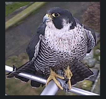
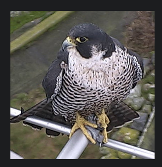
Unusual footage taken by Pam Birley using the remote camera 5 of a falcon eating a seabird. Also see similar sequence on right below..


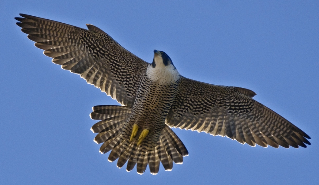
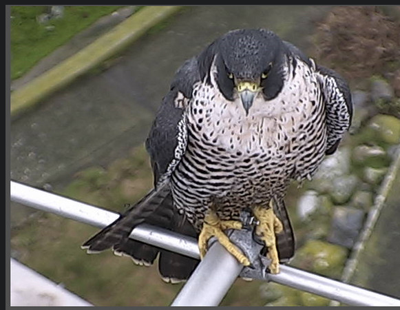
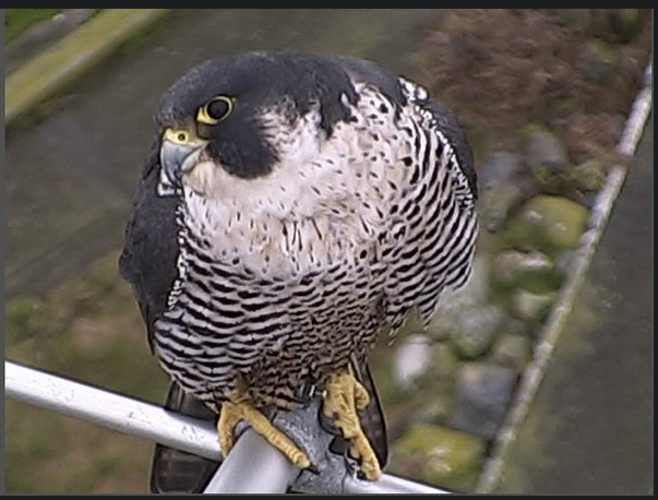
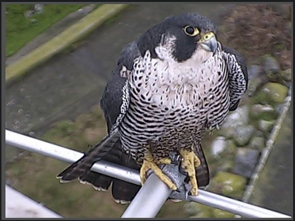
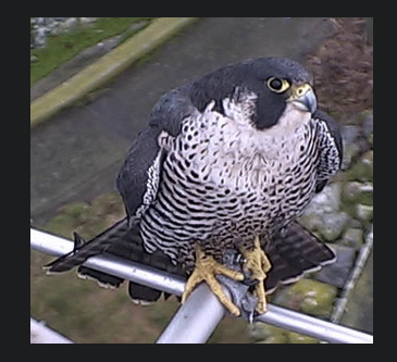
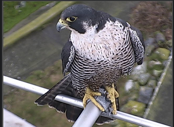
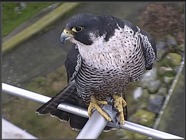
The Peregrine falcon, Falco peregrinus, is a bird of prey (or raptor) which has captured the attention and imagination of ornithologists and bird-watchers alike for several thousand years. With a body length of 15-20 inches and a body weight of 1.25-3.75 lbs, the falcon is built specifically for travelling at high speeds (up to 180 m.p.h.) in order to catch its prey. The name Falco peregrinus is derived from the Latin falx, or sickle-shaped, and peregrinus, meaning wandering. It is unclear whether the former is derived from the shape of the bird’s silhouette in the sky or from the shape of its beak, but the latter name comes undoubtedly from its propensity to migrate great distances.
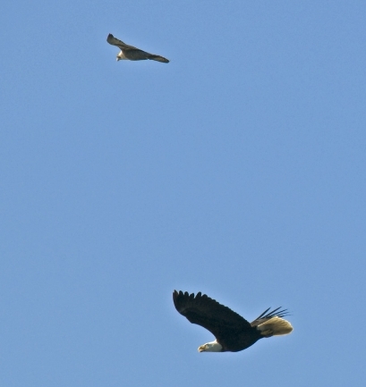
In the picture of a Peregrine Falcon and Bald Eagle from his Flickr site, Ryan Murphy said
“This was amazing to witness in person, I regret not having been able to capture it better than this! Just before this the eagle rolled backwards towards the chasing falcon… awesome aerial battle!”
Predation
Two sequences of pictures from Race Rocks below have been taken by Pam Birley showing the peregrine eating a shorebird.and a sea gull. Though peregrine falcons, like other birds of prey, are considered to be near the top of the food web, they are not completely free from predators. Great horned owls and golden eagles have been known to attack them. Humans have also been known to take their eggs in hopes to raise the falcons for hunting purposes.
As top predators, peregrine falcons play an important ecosystem role in regulating the populations of their prey.
Habitat
Peregrine Falcons prefer open habitats such as grasslands, tundra, and meadows. They nest on cliff faces and crevices. They have recently begun to colonize urban areas because tall buildings are suitable for nesting in this species, and because of the abundance of pigeons as prey items.
Peregrine falcons prey almost exclusively on birds, including mourning doves, pigeons, shorebirds, (see slide shows above) waterfowl, and smaller songbirds. They will also eat small reptiles and mammals. Although peregrine falcons capture their prey with their claws, they generally kill prey with their beak.The photos for this slide show and video were taken on the remote camera 5 at Race Rocks, by Pam Birley operating the camera from Great Britain. Pam had observed the peregrine falcon on various perches around the island in the mornings for several weeks in October and November. Her persistence paid off on November 17, 2005. Pam wrote in her e-mail ….”Today we had just returned home .. I just came up to the computer, switched it on and there was Perry with his breakfast….I really caught him in the act of devouring his prey today! You may see other pictures that Pam has taken using the remote camera at Race Rocks by clicking here to go to her photo album .
CLICK ON THE BLANK SPACE

PEREGRINE FALCONS AT RACEROCKS: OCTOBER, 2004

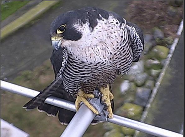
Pam Birley of Leicester England captured some of the pictures remotely on robotic camera 5 and Mike Slater, our reserve guardian took the pictures of the antenna perch on the towerPam was interviewed recently about her wildlife viewing on racerocks.com
ref: Anderson, Charlie, “Live Wildlife for your Living Room “,
The Province (newspaper) , Vancouver, B.C. ( Sunday, Nov.21, 2004)

Conservation Status
Peregrine falcons have suffered due to their dangerous position atop the food chain. Pesticides accumulate in small (not lethal) quantities in the tissues of small birds and mammals, but become concentrated enough in predatory birds, such as falcons, to kill them or render them incapable of producing offspring. Organochlorine pesticides (DDT and dieldrin) have been proven to reduce the birds’ ability to produce eggshells with sufficient calcium content, making the egg shells thin and more likely to break. Peregrine falcon populations dropped greatly in the middle of the 20th century, they were threatened worldwide by the increasing use of pesticides. All breeding pairs vanished in the Eastern United States. A successful captive breeding/reintroduction program, combined with restrictions in pesticide use, has been the basis of an amazing recovery by peregrine falcons. Now the use of many of the chemicals most harmful to these birds is restricted. It is not yet restricted in the areas of Central and South American where many subspecies spend the winter. After having been on the endangered list since 1969, the incredible recovery of Peregrine Falcons has become a perfect example of how effective human conservation can be. In the 1990’s they were taken off the lists of endangered species in the United States.

Jan 25, 2010 Brian Mury sent this link to a set of images he took from Camera 1 on the top of the tower. The falcon is perched on the FM antenna which is used by Environment Canada to transmit anemometer readings from the top of the tower.


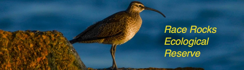
Other Members of the Class Aves at Race Rocks.

taxonomyiconReturn to the Race Rocks Taxonomy
and Image File
pearsonlogo2_f2The Race Rocks taxonomy is a collaborative venture originally started with the Biology and Environmental Systems students of Lester Pearson College UWC. It now also has contributions added by Faculty, Staff, Volunteers and Observers on the remote control webcams.

Chiara Ravetti PC yr 31


The Ecological Niche defined by Abiotic Factors

EconicheThe file linked here was included to illustrate the concept of the Ecological Niche of an organism. Ecological Niches are determined by all the Biotic and Abiotic factors that make up the limiting factors on an organisms environment. It is impossible to represent in a diagram all the factors which define the full ecological niche. After studying the two references linked on this page, write a discussion on how our built-up environments with cats, lawns, and other introduced species limit the ecological niches available and thus impact negatively on Biodiversity.

anthopleura
“The ecological niche of Anthopleura elegantissima at Race Rocks”
In this research essay, Santiago has adapted a tool from EXCEL to illustrate his concept of the “cloud” that represents an Ecological Niche of a sea anemone. This is an original interpretation and one which helps us visualize the dimensions of niche requirements.

Limiting Factors: The Bumpus Paper

malesparrowA classic study done over a century ago has provided the data for many studies on limiting factors of the environment, See this PDF, partially quoted here from The Condor Journal : For the complete article go to http://elibrary.unm.edu/sora/Condor/files/
issues/v094n04/p0944-p0954.pdf


 INTRODUCTION
Nearly a century ago, Hermon Bumpus received 136 House Sparrows (Passer domesticus) that had been collected after a severe winter storm in Providence, Rhode Island (Bumpus 1899). Over half of these birds revived in his laboratory and Bumpus proceeded to evaluate physical characteristics that might distinguish these survivors from their dead counterparts. He concluded that the storm had taken a greater toll on individuals whose morphometrics deviated most from the “ideal type” (Bumpus 1899). Bumpus was unabashed in claiming this pattern of differential survival to be due to the agency of natural selection. The provocative nature of his interpretation, coupled with publication of the complete data set on which it is based, has prompted repeated analysis of Bumpus’ study (e.g., Harris 1911, Calhoun 1947, Grant 1972, Johnston et al. 1972, Lande and Arnold 1983, Crespi and Bookstein 1989). Studies reappraising the Bumpus data generally agree that females suffered proportionately greater mortality than males and that female survivorship reflects stabilizing or normalizing selection (Grant 1972, Johnston et al. 1972, Lande and Arnold 1983). Disagreement persists, however, in deciding whether male survivorship reflects directional selection and, if so, whether this selection favors larger (Johnston et al. 1972) versus smaller individuals (Lande and Arnold 1983, Clutton-Brock 1988). Such contradictory conclusions from the same data set reflect differences in confidence that var- ious authors place in Bumpus’ morphometric measures. Those accepting at face value all nine of Bumpus’ morphometric measures conclude that the winter storm selected against larger adult males, because male survivors had significantly less mass and shorter total length than did their dead counterparts. On the other hand, some contend that his measures involving plumage (alar extent and total length) and mass may be biased, albeit for different reasons, and should not be considered when comparing characteristics of survivors to non-survivors (Calhoun 1947, Grant 1972, Johnston et al. 1972, Crespi and Bookstein 1989). When analysis is restricted to each of the six skeletal measures, adult male survivors and non-survivors cannot be distinguished from one another.

FOR FURTHER INVESTIGATION:
The following original papers present the arguments for natural selection by abiotic factors in the environment:
BUMPUS, H. C. 1899. The elimination of the unfit as illustrated by the introduced House Sparrow, Passer domesticus. Biol. Lectures, Marine Biol. Lab., Woods Hole:209-226.

JOHNSTON, R. F., D. M. NILES, AND S. A. ROHWER. 1972. Hermon Bumpus and natural selection in Passer domesticus.

PRICE, T. D., P. R. GRANT, H. L. GIBBS, AND P. T. BOAG. 1984. Recurrent patterns of natural selection in a population of Darwin’s Finches. Nature 309:787-789.
Return to the Assignment on Ecosystem Structure and Function

Return to the OceanQuest Index

Shipwrecks around Race Rocks

The islets may be shrouded in fog for up to 45 days a year. With only the station bell for a keeper to sound in the fog, Race Rocks was for many years the final resting place of the ships of unsuspecting crews drawn to the reefs by the relentless tide rips. Unfortunately, because of the strong currents, most shipwreck evidence has been swept off the rocks into water too deep for regular diving.

he Nanette.. sank in 1860
Three days before the new light was lit, tragedy struck. If there was ever any doubt about the need for the lighthouse structure the loss of the 385 ton tall ship Nanette proved it. Without the warning the new light was to provide only three days later, the Nanette ran hard aground on Race Rocks and was a total loss.

The Nanette’s mate William McCullogh wrote in the ship’s log:

“At 8 o’clock saw a light bearing N by W [this must have been the new light at Fisgard lit only six weeks earlier] Could not find the light marked on the chart. At 8 1/2 o’clock it cleared somewhat, and then saw the point of Race Rocks the first time, but no light. Called all hands on deck, as we found the ship was in a counter current, and drifting at a rate of 7 knots toward the shore. We made all possible sail, but to no avail.”

With the assistance of the construction gang the crew of the Nanette found shelter although the lightstation boat was also lost. HMS Grappler was able to rescue the crew from Race Rocks the next day. The cargo of the Nanette , valued at over $160,000 was strewn across the rocks surrounding the stricken hull. This prize attracted many eager locals hoping to salvage what they could. One overly ambitious crew perished when their over loaded canoe capsized off Albert Head tossing five men, a woman and her 18 month old baby into the sea.


The Loss of the Nanette, 1860

The Mystery wreck.. possibly the Idaho discovered at Race Rocks
The SS Nicholas Biddle ..sank January 5, 1867.Feb 5, 1867

Disaster to the ship Nicholas Biddel- ran aground on Rosedale reefThe Swordfish, sank .. November 6 1877
Nov. 7 1877

Wreck of the HMS Swordfish off Beecher bay

Nov. 7 1877H.M.S.Opal rescues crew of the SwordfishNov.11 1877Sale of the Swordfish ( wreckage)In 1978, PC student Alex Guevarra and faculty member Garry Fletcher while diving on this wreck, discovered a cast iron cannon. The cannon was retrieved after some effort and under the direction of Pearson College Anthropology teacher Brad Myers, was restored over a period of 10 years in a solution with electrolysis. It was transferred to Race Rocks and now sits on a cradle, made by a former light keepers assistant, at the base of the tower. It has been found out since that the cannon was probably being carried as ballast on the ship. We found out It had been was cast in Glasgow in 1790, in a set of cannons that all had oval bores. The set was subsequently sold off as scrap metal.

November 2, 1886 The Barnard Castle, a coal freighter en route from Nanaimo to San Francisco struck Rosedale Rocks on , but made it to nearby Bentinck Island where it now lies in 12 meters of water. See this image from the BC Archives. (Image A-0007)
also this link: 


The Wreck of the Idaho: Little is known about this wreck, but it is believed by the BC Underwater Archeological Society to be the designation of a wreck that lies off Rosedale reef. The pictures below by Jacques Marc, in the late 1990’s show the extensive evidence of this wreck.


In 1892 the Department of Marine and Fisheries installed a steam plant and two compressed air fog horns at Race Rocks. The Department had taken over operation of lighthouses from the British Admiralty in 1871 when British Columbia joined the Dominion of Canada. Despite the addition of the powerful horns, tragedies continued at Race Rocks.

In 1896 the SS Tees crashed ashore,
followed by the Prince Victor in January 1901.
The worst disaster occurred on the dark night of March 24, 1911. The ferry Sechelt , bound for Sooke from Victoria found herself fighting a fierce westerly gale as she headed out the strait past Race Rocks. The captain decided against bucking the gale past Beechy Head and made the decision to make a fateful change of course to return his ship to the shelter of Victoria harbour. Caught in a beam sea the Sechelt capsized and sank rapidly taking her crew and 50 passengers with her to the bottom of Race Passage.


In July of 1923 the liner Siberian Prince went aground within a mile of the lighthouse without ever hearing the horn. Reports are that it was floated free.


On November 2, 1925 the Holland America liner Eemdijk also ran aground in almost the same location. Again the ship’s crew reported they did not hear the fog horns from nearby Race Rocks.>The tug Hope was lost with her crew of seven while attempting to salvage the Eemdijk . In 1927 Race Rocks was the first station on Canada’s West Coast to be fitted with a radio beacon. This did a great deal to prevent further tragedy.


And we still get shipwrecks at Race Rocks!


Lopholithodes mandtii : The Puget Sound King Crab–The Race Rocks Taxonomy

We often encounter these very large Puget Sound King Crabs in the calm backwaters of Race Rocks. Juveniles may be found among the cobble. Sea urchins and other echinoderms form their diet.


Paul Michaluk a fomer PC student from New Zealand, captured this picture on the left of Garry holding a  a Lopholithodes brought up by the divers who were back for a PC alumni reunion

Another former student, Barb Holman, took the picture on the right of Garry demonstrating the size of a Puget Sound King crab at Race Rocks to Trish Holman in April, 1998
Domain Eukarya
Kingdom Animalia
Phylum Arthropoda
Subphylum Crustacea
Class Malacostraca
Order Decapoda
Family Lithodidae
Genus Lopholithodes
Species mandtii

Common Name: Puget Sound King Crab

See a post by our ecoguardian Mike Robinson in 2012

pearsonlogo2_f2The Race Rocks taxonomy is a collaborative venture originally started with the Biology and Environmental Systems students of Lester Pearson College UWC. It now also has contributions added by Faculty, Staff, Volunteers and Observers on the remote control webcams. 


Daily Air Data :Race Rocks Ecological Reserve 2002-2005

SORRY THE LINKS HAVeYET TO BE UPDATED HERE

We have a number of past records in EXCEL format which are converted to html for publication here.

See the file on Temperature for recent records and the abiotic effects of temperature on organisms.

These files may be copied from your browser and placed in an EXCEL or AppleWorks spreadsheet for exercises involving further analysis and graphing

Go here for instructions for a lab exercise on transferring this data to an EXCEL workbook on your own computer.


 temperature archives

AIR DATA JANUARY, 2002

AIR DATA FEBRUARY, 2002

AIR DATA MARCH, 2002

AIR DATA APRIL, 2002

AIR DATA MAY, 2002

AIR DATA JUNE, 2002

AIR DATA JULY, 2002

AIR DATA AUGUST , 2002

AIR DATA SEPTEMBER , 2002

AIR DATA OCTOBER, 2002

AIR DATA NOVEMBER, 2002

AIR DATA DECEMBER, 2002


October 1984 to February 1997 daily weather records submitted to Environment Canada Meteorological Service by the light keepers at Race Rocks.

Be sure to do a Customized Search for
“Race Rocks Lightstation” to find this archive
.

We think prevous records exist so we are trying to get them from the Canadian Meteorlogical Service.


AIR DATA JANUARY, 2003

AIR DATA FEBRUARY, 2003

AIR DATA MARCH, 2003

AIR DATA APRIL, 2003

AIR DATA MAY, 2003

AIR DATA JUNE, 2003

AIR DATA JULY, 2003

AIR DATA AUGUST, 2003

AIR DATA SEPTEMBER, 2003

AIR DATA OCTOBER, 2003

AIR DATA NOVEMBER, 2003

AIR DATA DECEMBER, 2003

AIR DATA, JANUARY 1998
(missing first three months)

AIR DATA, FEBRUARY 1998

AIR DATA, MARCH 1998

AIR DATA, APRIL 1998

AIR DATA, MAY 1998

AIR DATA, JUNE 1998

AIR DATA, JULY, 1998

AIR DATA, AUGUST, 1998

AIR DATA SEPTEMBER, 1998

AIR DATA OCTOBER, 1998

AIR DATA NOVEMBER, 1998

AIR DATA DECEMBER, 1998


AIR DATA JANUARY, 2004

AIR DATA FEBRUARY, 2004

AIR DATA MARCH, 2004

AIR DATA APRIL, 2004

AIR DATA MAY, 2004

AIR DATA JUNE, 2004

AIR DATA JULY, 2004

AIR DATA AUGUST , 2004

AIR DATA SEPTEMBER , 2004

AIR DATA OCTOBER, 2004

AIR DATA NOVEMBER, 2004

AIR DATA DECEMBER, 2004


AIR DATA, JANUARY 1999

AIR DATA, FEBRUARY 1999

AIR DATA, MARCH 1999

AIR DATA, APRIL 1999

AIR DATA, MAY 1999

AIR DATA, JUNE 1999

AIR DATA, JULY, 1999

AIR DATA, AUGUST, 1999

AIR DATA SEPTEMBER, 1999

AIR DATA OCTOBER, 1999

AIR DATA NOVEMBER, 1999

AIR DATA DECEMBER, 1999


AIR DATA JANUARY, 2005

AIR DATA FEBRUARY, 2005

AIR DATA MARCH, 2005

AIR DATA APRIL, 2005

AIR DATA MAY, 2005

AIR DATA JUNE, 2005

AIR DATA JULY, 2005

AIR DATA AUGUST , 2005

AIR DATA SEPTEMBER, 2005

AIR DATA OCTOBER, 2005

AIR DATA NOVEMBER, 2005

AIR DATA DECEMBER, 2005


AIR DATA, JANUARY 2000

AIR DATA, FEBRUARY 2000

AIR DATA, MARCH 2000

AIR DATA, APRIL 2000

AIR DATA, MAY 2000

AIR DATA, JUNE 2000

AIR DATA, JULY, 2000

AIR DATA, AUGUST, 2000

AIR DATA SEPTEMBER, 2000

AIR DATA OCTOBER, 2000

AIR DATA NOVEMBER, 2000

AIR DATA DECEMBER, 2000


From January 2006 on, refer to the air temperature files from the Davis Weather Instrument.

Archived Data for this page has been produced in the EXCEL Files by Mike Slater. It was then converted and saved as html by Garry Fletcher and students of the racerocks.com activity


AIR DATA, JANUARY 2001

AIR DATA, FEBRUARY 2001

AIR DATA, MARCH 2001

AIR DATA, APRIL 2001

AIR DATA, MAY 2001

AIR DATA, JUNE 2001

AIR DATA, JULY, 2001

AIR DATA, AUGUST, 2001

AIR DATA SEPTEMBER, 2001

AIR DATA OCTOBER, 2001

AIR DATA NOVEMBER, 2001

AIR DATA DECEMBER, 2001


racerocks.com home page
Sitemap Contact
webmaster:
Garry Fletcher
Copyright


Substrate analysis for the Tidal Energy Project

Chris Blondeau and Juan Carlos video the substrate at the site of the tidal energy piling installation. This is prior to the pile drilling operation for the Pearson College-ENCANA_Clean Current Demonstration Tidal Current Energy Project. They find bedrock in the area 30 cm under the surface at a depth of 24 meters of water.


See other archived video with Pearson College Divers

Invertebrate Scenes from the video:

metrid2

Metridium anemone with hydrocoral

hydroid

Hydroids

cribrinopsis

Cribrinopsis anemone and brooding anemones

bloodstar

Blood star and yellow sponge

generatorsLink to the Integrated Energy Project at Race Rocks

BC Parks Impact Assessment Process

FIle No: 85700-35-0210206

Name of Action:       Construction and Pile Drilling for Current Turbine Project  

Proponent:               Lester B Pearson College

Review Date(s):         Nov 2, 2005             

  1. Issues and Environmental Components
  2. List any issues of concern that have been or may be raised by BC Parks, other government agencies, First Nations, or the public.

2 Identify any geographic “hotspots” at or close to the proposed action (e.g., areas of high use, concentrations of facilities, wilderness conservation zones, unique landscape features).

Below are the relevant items that we are contributing to this Preliminary Assessment, the third in a series leading up to this project. If further items are provided in the next few weeks, they will be updated here:

Location: The proposed location of the Tidal Current Generator Piling for the Cradle is shown below. This site was chosen after extensive testing of the current profiles in both channels with the Acoustic Doppler Current Profiler.

The red lines indicate the Pearson College  permit access area..


3. Identify any important environmental, recreational, social or economic values in the area of the proposed action and/or the area surrounding the proposed action (e.g., rare or endangered species, hiking experience, midden site). Include a rationale as to why the value is considered important.

The location for the installation is in the current channel just South of North Rock, with the typical associations of organisms of the highly current swept areas of the island. Since the depth is up to 20 meters, there are few macroalgae present.

Archipelago marine has done a SIMS towed video CD . The route they took and the timing of the footage was done according to this Chart. Video taken by Pam Thuringer in the area of the chart missed by the towed video is now available from Archipelago marine

Some footage taken by the Pearson College Divers which shows the bottom fauna in the area of the turbine piling is located here:

In order to predict the best location for the installation of the tidal power generator, an ADCP ( Acoustic Doppler Current Profiler) supplied by ASL Environmental Sciences was deployed. This instrument will collect current regime information for a period of one month. Rita Santos did the video and Angie Karlsen helped Chris Blondeau lift and position the concrete weights used to secure the device on the sea floor..

For an idea of the general patterns of organism distribution, the two clips below were taken from the video which was filmed at the location of the ADCP research at Station2:

Preliminary Screen Checklist (partial)

C. Level 1 report should recommend appropriate times and methods for construction to ensure birds /wildlifeimpacts are kept to a minimum.

Date of work: The installation in November is timed after the nesting and seal pupping season and in the time of the year when the Sea Lions have returned but are concentrated in the area to the East of the docks, on South Rock and on Middle and West Island. The closest population that may be disturbed by the drilling is on North Rock, and part of Middle Rock. In the past that population frequently comes and goes probably because of the fall schedule of blasting by DND .

Construction Method: We have been advised that a contract has been let by Clean Current for the drilling and installation of the piling to bear the generator to:

Fraser River Pile & Dredge Ltd. (FRPD)1830 River Drive
New Westminster, B.C.
V3M 2A8
Tel: (604) 528-9333
(Project manager Rick Gillis)

The attached .pdf file.. Construction Drilling provides the details of this phase of the project.

The amount of oil consumed in the drilling operation is approximately 5 gallons /hr. For a drilling depth of 8 m, the operation should take 4-5 hours. The drilling operation will not produce an oil slick. In the event of a spill FRPD, will employ their standard method of deploying containment booms and pads to contain the oil. Due to the challenging conditions in this area, FRPD will have additional booms and pads on board.
The drilling operation is a closed system. All drill cuttings will be brought to the surface and then processed through a cyclone which will separate the cuttings from the water. The water and entrained air will then be returned to the ocean via a pipe at a depth of approx. 20 ft. All of the cuttings will be collected on a scow that is tied up along side the drilling barge.The cuttings will be taken ashore for disposal.
Six anchor blocks of approximately 6’ x 6’ x 6’ will be used to anchor the drilling rig in position. Each of these blocks can be dropped at a predetermined location; however, depending on the current during this operation, the actual location may differ from the intended spot. Also, once all 6 blocks are in position, the anchor lines will be tensioned to firmly lock the barge in position. During this winching operation, it is very possible for the blocks to slide a short distance along the seabed until they lock in position. The thinking now is that 4of these blocks will left in place for the duration of the Tidal Generator Project. This will avoid further damage to the bottom in future operations where a barge will have to be employed for the lifting of the generator on regular (yeaarly) basis for servicing.

Equipment

Island Tug operates a large fleet of tugs and barges including one self-propelled cable layer. The principal method of cable handling utilizes one of two powered self-breaking drums. Reel number 1 has a capacity for 80,000 feet of 2-inch diameter cable with a break holding capacity of 200 tons. Reel number 2 has a capacity for 30,000 feet of 2-inch diameter cable with a break holding capacity of 100 tons.

Procedure of Cable Laying – General

Reel number 2 is mounted aboard the cable layer, Georgia Transporter. Cable is transferred from shore storage reels to the ship-mounted reel and transported to the site. Cable is taken ashore at the cable shore-end via a bow mounted adjustable ramp. A bow mounted cable chute is used to deploy the cable while the Georgia Transporter is towed astern. Two GPS systems monitor the surface position and provide feedback via digital charts. Track corrections are implemented through a variety of methods using the Ship’s power, directing the towing vessel or employing side boats. For shallow water lays, the cable tension is not monitored by equipment but by the angle off the bow, with lay and reel speeds corrected as necessary. For deep-water lays, the cable tension is monitored with on deck tension monitoring equipment such as linear tension devices or load cells. Cable weights and water depth information are pre plotted along a planned track in order to adjust for the intended tension at given positions.

Reel number 1 is mounted aboard one of Island’s flat deck barges and used in the same manner as the description above, with the exception that the barge will start and finish on four point moorings.

Island Tug And Barge Ltd.
R.L. (Bob) Shields
President

Piling Construction:

Further details of the column construction in the figure above can be obtained from a .pdf file from Clean Current
On Site Supervision: Chris Blondeau, operations manager, and Garry Fletcher, Ecological Reserve Warden will be available to oversee the environmental concerns. In addition, Pam Thuringer and staff of Archipelago Marine have been contracted to do an ongoing environmental assessment for the duration of the construction phase of the project.
Recommendations:1. If it is possible, we recommend the temporary displacement of any of the larger motile invertebrates such as sea urchins, sea stars and sea cucumbers in the impacted area while the project is being carried out, with their return to the same approximate habitat upon completion. This may however not be feasible given the nature of the operation and the timing.

2. Working at this time of year could involve difficult weather conditions. It must be emphasized that the safety of personnel and the ecological reserve is paramount.

Prepared by G. Fletcher Nov 2, 2005