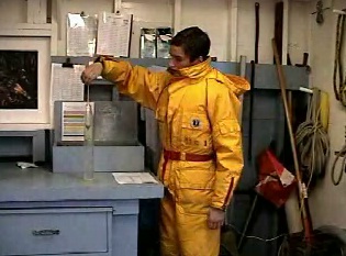
 Jeremias tests the salinity using a hydrometer. This manual method has been used at Race Rocks from 1935 until more recent years when a digital salinometer has been used.
For monthly records of Salinity refer to :
https://www.racerocks.ca/?s=Salinity&submit=Search
“During our project week at Race Rocks, Mike Slater, the Race Rocks Marine Protected Area Guardian asked us if we could make a video explaining the daily duties necessary to maintain the facility. Students who are relieving on the island during Mike’s absence will be able to use this data as a guide for performing their duties, as well as providing a useful information resource for students visiting the island.
These duties include two daily engine checks, a salinity check one hour before high tide, and keeping a record of the days weather, as well as explaining the functions and instructions for testing machinery located on the island.”
ABIOTIC EFFECTS OF SALINITY ON ORGANISMS
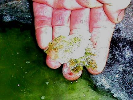 Organisms which live in Tidepools have to withstand changing salinities which may range from 0 parts per thousand to over 100 parts per thousand. Here is an example of an algae that in the summer lives in concentrated brine of the evaporated tidepool number 7.
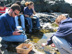 Rob measures salinity with the salinometer in tidepool Number 4..This file shows the results that one class in environmental systems got when measuring the salinities of tidepools. Note there can be quite a variation in both temperature and salinity, depending on the elevation of the pool and therefore the frequency of flooding from the ocean.
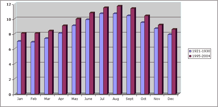
Mean Monthly Sea Surface Salinity at Race Rocks-1936 to present .
Two decades of mean monthly Salinity records are compared in the following investigation.
Salinity Comparisons for 2 Decades
There are a number of interesting features of the two decades almost 50 years apart.
Some open-ended questions that you may wish to pursue:
- How do the individual months compare?
- Is there any evidence of a trend that distinguishes the earlier decade from the most recent one?
- Is there any evidence of a trend that distinguishes one period of the year from another?
- What could be the cause of any observable trends?
- Does geographic location of Race Rocks provide an answer to any findings?
- See the work done on comparing sea temperature from two decades for some other ideas.
- What would the graphs look like if you took the means of each month from the two decades and plotted them ?
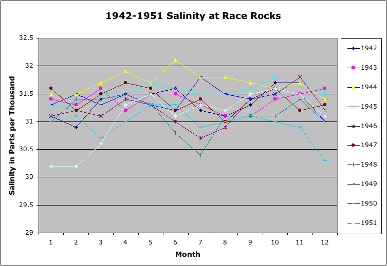
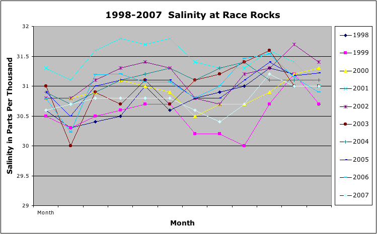
You may also see the the raw data used to make the graphs in the two tables below. It may be useful in this format to clip and paste into an EXCEL workbook for further analysis. If you come up with any other interesting analysis of the data from this exercise or from looking at the complete data archive. We would be interested in carrying it attached to this page.
| Raw Data |
|
1942 |
1943 |
1944 |
1945 |
1946 |
1947 |
1948 |
1949 |
1950 |
1951 |
| Jan. |
31.1 |
31.4 |
31.5 |
31.3 |
31.1 |
31.6 |
31 |
31.3 |
31.1 |
30.2 |
| Feb. |
30.9 |
31.3 |
31.5 |
31.2 |
31.2 |
31.2 |
31.4 |
31.5 |
31.1 |
30.2 |
| Mar. |
31.4 |
31.6 |
31.7 |
31.5 |
31.1 |
31.5 |
31.4 |
31.3 |
30.7 |
30.6 |
| Apr. |
31.5 |
31.2 |
31.9 |
31.5 |
31.4 |
31.7 |
31.5 |
31.5 |
31 |
31.3 |
| May |
31.5 |
31.5 |
31.7 |
31.7 |
31.3 |
31.6 |
31.3 |
31.3 |
31.3 |
31.5 |
| June |
31.6 |
31.5 |
32.1 |
31.6 |
31 |
31.2 |
30.8 |
31.2 |
31.3 |
31.1 |
| July |
31.2 |
31.3 |
31.8 |
31.5 |
30.7 |
31.4 |
30.4 |
31.8 |
30.9 |
31.3 |
| Aug. |
31.1 |
31.1 |
31.8 |
31.5 |
30.9 |
31 |
31.1 |
31.5 |
31 |
31.2 |
| Sept. |
31.3 |
31.1 |
31.7 |
31.6 |
31.4 |
31.4 |
31.1 |
31.4 |
31.1 |
31.5 |
| Oct. |
31.7 |
31.4 |
31.6 |
31.8 |
31.5 |
31.6 |
31.1 |
31.5 |
31 |
31.6 |
| Nov |
31.7 |
31.5 |
31.7 |
31.8 |
31.8 |
31.2 |
31.4 |
31.5 |
30.9 |
31.5 |
| Dec |
31.4 |
31.6 |
31.4 |
31.5 |
31.2 |
31.3 |
31 |
31 |
30.3 |
31.1 |
|
|
|
|
|
|
|
|
|
|
|
|
1998 |
1999 |
2000 |
2001 |
2002 |
2003 |
2004 |
2005 |
2006 |
2007 |
| Jan. |
30.6 |
30.5 |
30.8 |
31.3 |
30.8 |
31 |
30.9 |
30.9 |
30.79 |
30.6 |
| Feb. |
30.3 |
30.3 |
30.8 |
31.1 |
30.8 |
30 |
30.7 |
30.5 |
30.23 |
30.7 |
| Mar. |
30.4 |
30.5 |
30.9 |
31.6 |
31.1 |
30.9 |
30.9 |
31 |
31.19 |
30.8 |
| Apr. |
30.5 |
30.6 |
31.1 |
31.8 |
31.3 |
30.7 |
31.1 |
31.1 |
31.2 |
30.8 |
| May |
31 |
30.7 |
31 |
31.7 |
31.4 |
31.1 |
31.2 |
31.1 |
31.07 |
30.8 |
| June |
30.6 |
30.7 |
30.9 |
31.8 |
31.3 |
30.7 |
31.3 |
31.1 |
31.07 |
30.8 |
| July |
30.8 |
30.2 |
30.5 |
31.4 |
30.8 |
31.1 |
31.1 |
30.8 |
30.81 |
30.6 |
| Aug. |
30.9 |
30.2 |
30.7 |
31.3 |
30.7 |
31.2 |
31.3 |
30.8 |
31 |
30.4 |
| Sept. |
31 |
30 |
30.7 |
31.3 |
31.2 |
31.4 |
31.4 |
31.1 |
31.46 |
30.7 |
| Oct. |
31.3 |
30.7 |
30.9 |
31.6 |
31.3 |
31.6 |
31.1 |
31.4 |
31.54 |
31.2 |
| Nov. |
31.2 |
31.2 |
31.2 |
31.4 |
31.7 |
31 |
31.1 |
31.18 |
31.15 |
31 |
| Dec. |
30.7 |
30.7 |
31.3 |
31 |
31.4 |
31 |
31.1 |
31.22 |
30.9 |
31 |
|
|
|
|
|
|
|
|
|
|
|
|

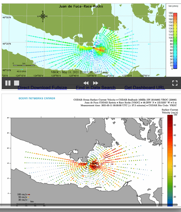
 CODAR SeaSonde continuous surface current mapping and wave monitoring HF radar system.