This spreadsheet was made by Garry Fletcher as part of the Race Rocks ecological overview done for DFO . The links have not been updated since the website had to be moved from the Telus Server. The references are also housed in the bookshelf in the Marine biology lab at Pearson College. This alternate link here may be preferable here also: Most references should also be available in a google search.
| References ID | Reference Type | Author1, Author2, Author3 | year | Title | Journal, report, book title | editor | Volume | Number | page | URL | Call Number | Abstract | Comments | Links |
|---|---|---|---|---|---|---|---|---|---|---|---|---|---|---|
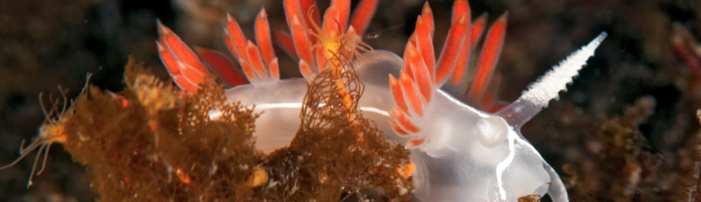
| 2 | Refereed Journal | Brinckmann-Voss – Anita | 1996 | Seasonality of Hydroids (Hydrozoa, Cnidaria) from an intertidal pool and adjacent subtidal habitats at Race Rocks, off Vancouver Island, Canada | Scientia Marina | . | 60 | 1 | 89-97 | rrrefer/Anita’s/seasonal.htm | 593.55 Bri S | None available– See Comments or Links | Includes useful section on systematics, line maps of the Race Rocks Area, and species lists of hydroids from specific tidepools and subtidal areas. Complete text and diagrams included in link. | http://www.racerocks.com/racerock/hydroid/pub/seasonal.htm |
| 3 | Refereed Journal | Brinckmann-Voss- Anita,Lickey-D.M.,Mills-C.E. | 1993 | Rhysia fletcheri (Cnidaria, hydrozoa, Rhysiidae), a new species of colonial hydroid from Vancouver Island ( British Columbia, Canada) and the San Juan Archipelago ( Washington, U.S.A.) | Can.Journal of Zool. | . | 71: | 2 | 401-406 | Rhysia/Rhysia.htm | 593.55 Bri | A new species of colonial athecate hydroid, Rhysia fletcheri , is described from Vancouver Island, British Columbia, Canada, and from Friday Harbour, Washington, U.S.A. It’s relationship to Rhysia autumnalis Brinckmann from the Mediterranean and Rhysia halecii (Hickson and Gravely) from the Antarctic and Japan is discussed. Rhysia fletcheri differs from Rhysia autumnalis and Rhysia halecii in the gastrozooid having distinctive cnidocyst clusters on its hypostome and few, thick tentacles. Most of its female gonozooids have no tentacles. Colonies of R. fletcheri are without dactylozooids. The majority of R. fletcheri colonies are found growing on large barnacles or among the hydrorhiza of large thecate hydrozoans. Rhysia fletcheri occurs in relatively sheltered waters of the San Juan Islands and on the exposed coast of Southern Vancouver Island. | Microphotographs of male and female specimens and Systematics discussion are included with the description of this new species found at Race Rocks. Color photographs by the author of male and female specimens are included in the link to the article. We wish to acknowledge the National Research Council of Canada who have kindly consented to the printing of this article. We also wish to thank the author, Dr. Anita Brinckmann-Voss for providing the color photographs of the specimens for the web site | http://www.racerocks.com/racerock/hydroid/anitabv.htm |
| 4 | Refereed Journal | Ford, John K.B. | 1991 | Vocal Traditions among resident killer whales(Orcinus orca) in coastal waters of British Columbia | . | . | 69 | . | 1454-1481 | . | . | Underwater vocalizations were recorded during repeated encounters with 16 pods, or stable kin groups, of killer whales (Orcinus orca) off the West Coast of British Columbia. Pods were identified from unique natural markings on individuals. Vocal exchanges within pods were dominated by repetitious discrete calls. Pods each produced 7-11 (mean 10.7) types of discrete calls. Individuals appear to acquire their pod’s call repertoire by learning, and repertoires can persist with little change for over 25 years. Call repertoires differed significantly among pods in the resident population. The 16 pods formed four distinct acoustic associations, or clans, each having a unique repertoire of discrete calls or vocal tradition. Pods within a clan shared several call types but no sharing took place among clans. Shared calls often contained structural variations specific to each pod or group of pods within the clan. These variants and other differences in acoustic behavior formed a system of related pod-specific dialects within the vocal tradition of each clan. Pods from different clans often traveled together, but observed patterns of social associations were often independent of acoustic relationships. It is proposed that each clan comprises related pods that have descended from a common ancestral group. New pods formed from this ancestral group through growth and matrilineal division of the lineage. The formation of new pods was accompanied by divergence of the call repertoire of the founding group. Such divergence resulted from the accumulation of errors in call learning across generations, call innovation , and call extinction. Pod-specific repertoires probably serve to enhance the efficiency of vocal communication within the group and act as behavioural indicators of pod affiliation. The striking differences among the vocal traditions of different clans suggest that each is an independent matriline. | . | . |
| Walker- Bruce | 1987 | Pearson College Transect Data – Methods. | . | . | . | . | 9 | . | . | None available– See Comments or Links | Report on how to set up a transect and use transect data with reference to Race Rocks. | . | ||
| Helm – Denise | 1996 | Light station Falls into College Hands | Times- Colonist | . | Dec 12 | . | . | . | 577.7 Hel Ra | None available– See Comments or Links | . | . | ||
| , | Veiogo-Peniasi S. | 1991 | A study of the level of Parasitic Infection (in crabs) between two separate locations. | . | . | . | . | 30 | . | 578.65 Vei | Two locations were chosen to try to determine, and compare the level of parasitic infection between them. From each location, a total of forty crabs were observed for two species of parasites, and the test showed that there was, indeed, a difference in the level of parasitic infection between the two locations. I have purposely chosen in this study a few factors that could possibly be responsible for the observation stated above. In doing so, I picked factors that were most closely associated with the crabs and their natural habitats. Neither the sex nor the size of the crabs affects the level of infection in both the locations (i. e. there is no linear relationship between the level of infection and the size or sex of the crabs); the parasites infect all crabs with almost the same frequency showing no preference to any particular sex or size. Therefore, this is a very simple and straightforward study with the prime objective of solving an ecological problem, basing much of the conclusions on preliminary observations. Furthermore, this study tries to stimulate and encourage wider and more extensive research of marine parasites and their role in the ecology of marine life. |
Study to compare the level of parasitic infection between two different locations – Pedder Bay and Race Rocks. 40 crabs were observed for two parasites to observe if a relationship existed between the level of infection and the size of the hosts, as well as its sex. | . | |
| Odeh- Omar | 1991 | Microorganism association withHalosaccion glandiforme. | . | . | . | . | 36 | . | . | This study involves the microorganisms associated with Halosaccion glandiforme. The samples of Halosaccion glandiforme were taken from Race Rocks Island in the Race Rocks Ecological Reserve.In this study the main purpose was to detect the effect of certain characteristics of the habitat (Halosaccion glandiforme) on the diversity and population of the species present inside Halosaccion glandiforme. The results of this study show that the diversity and population of the species present in Halosaccion glandiforme is sometimes affected by the factors studied. The factors that were studied include total surface area of the sample, the location of the species within Halosaccion glandiforme and the fact that some samples have their top part open and others closed. | Study done in the Race Rocks ecological reserve to detect the effect of certain characteristics of the red algae habitat (H. glandiforme) on the diversity and population of the species present inside H. glandiforme. | . | ||
| Obee-Bruce | 1986 | Race Rocks | Beautiful British Columbia | . | . | . | . | rrrefer/obee/obee.htm | . | None available– See Comments or Links | Article about Race Rocks, off southern Vancouver Island. | . | ||
| Hardie-D.,Mondor-C | 1976 | Race Rocks National Marine Park- A Preliminary Proposal | . | . | . | . | 69 | rrrefer/rrnatpark.htm | . | None available– See Comments or Links | The federal- Provincial task force Working Group established in 1972 selected the marine and coastal area surrounding Race Rocks as one of several sites in the Strait of Georgia and Juan de Fuca Strait warranting further study as a potential marine park. In 1973 a second task force was given the responsibility of developing a proposal for establishing the same. Complete copy in this database. | . | ||
| Fisheries and Oceans Canada | 1998 | Marine Protected Areas Program Policy | . | . | . | . | 27 | http://www.oceansconservation.com | 577.7 Mar C | None available– See Comments or Links The Marine Protected Areas Program Policy provides the rationale for the Department of Fisheries and Oceans’ efforts with respect to the identification, development, establishment and management of Marine Protected Areas (MPAs) under the Oceans Act. |
The purpose of this document was to give the public an opportunity to review and comment upon the elements of the Marine Protected Areas Program. | . | ||
| Hagler- Bailly Consulting, DavidF.Dickens Associates,Robert Allan Ltd. | 1995 | Benefit-Cost Analysis of Establishing a Dedicated Rescue/Salvage Tug to Serve Canada’s Southern West Coast | . | . | . | . | 92 | . | . | This report provides a benefit-cost analysis for establishing one dedicated rescue/salvage tug near the entrance to Juan de Fuca Strait on the west coast of Canada. The primary role of the tug would be to rescue a disabled oil tanker or major vessel. The tugs area of operation is assumed to be a 78 nautical-mile radius from Bamfield, British Columbia, which is located along the southern portion of Barkley Sound. This area encompasses a wide portion of Pacific Rim National Park and extends as far southeast as Port Angeles and as far north as Clayoquot Sound. These areas contain physical, biological, and recreational resources that are at risk from oil spills, and that have been injured by oil spills in the recent past. |
Comments on Juan de Fuca Wildlife Impacts of Oil Spill Chapter 5 ” Benefits from establishing The rescue/Salvager Tugboat Program” is useful: Figures C1-C3 show oil spill paths in Strait of Juan de Fuca |
. | ||
| Anderson- David | 1989 | Report to the Premier On Oil Transportation and Spills | . | . | . | . | 110 plus 25 pages in appendix | . | 363.7394 And | This report is based on four month’s of public hearings in the coastal communities of British Columbia during the summer of 1989. The diverse proposals and recommendations coming from the public have been grouped, assessed, and where necessary supplemented, in order to come up with a coordinated and comprehensive series of recommendations to reduce marine oil spill risks and to improve response capability. The document is not focused on areas of provincial jurisdiction: the nature of the problems faced in oil spill prevention and response, the presentations of the public, and the approach of the Premier all suggest that the subject be considered as a whole. |
. | . | ||
| Water Management Services | 1971 | The Environmental Consequences of The Proposed Oil Transport Between Valdez and Cherry Point Refinery | . | . | . | . | . | . | 363.7382 Env | The hazard to the marine and coastal environments associated with tanker transport may be considered to occur in two related, but distinct, ways. One is the continuing leak of oil to the environment resulting from the myriad of routine operations associated with the oil industry, both intentional and accidental, which contributes the major but less spectacular contribution to marine oil pollution. The other is the spill arising from mishap (grounding, collision, structural failure or fire) in which all or a significant fraction of the cargo is released to the environment over a short period. |
. | . | ||
| Rosso- Giovanni E. | 1999 | Patterns of Color Polymorphism in the Intertidal Snail, Littorina sitkana at the Race Rocks Marine Protected Area | . | . | . | . | . | rreoref/polymor/giovee.htm | 594.3 Ros | As most intertidal gastropods, the Littorina sitkana shows remarkable variation in shell color. This occurs in both microhabitats that are exposed or sheltered from wave action. There appeared to be a close link between the shell coloration of the periwinkle and the color of the background surface. Fieldwork was carried out at the Race Rocks Marine Protected Area in order to investigate patterns of color polymorphism. Evidence from previous studies was also taken into account to better support interpretations and understand certain behaviors. The results showed that in the study site there was a very strong relation between the color of the shells and the color of the rocks. Light colored shells lived on light shaded rocks and vice versa. An interesting pattern was noticed on the white morphs. These were rare along the coast (Only 2%), but were present in relatively high numbers in tidepools set in white quartz. From previous experience (Ron J. Etter, 1988), these morphs seem to have developed, as an evolutionary response, a higher resistance to physiological stress from drastic temperature changes between tides. Some results showed that the white morph is present in an unexpectedly high percentage at the juvenile stage, but then their number decreases dramatically with age. As in Etter’s study, more research needs to be done on the role of visual predators in this phenomenon. |
This image shows both Black and white color variants of the Littorina sp. Here they are placed against the white quartz background in the shallow water of tidepool #4 | . | ||
| Goddard- James, M. | 1975 | The Intertidal and Subtidal Macroflora and Macrofauna in the proposed Juan de Fuca National Marine Park near Victoria, B.C. | . | . | . | . | 59 pages | rreoref2/jdfmarpk/juanmarpark.htm | . | None available– See Comments or Links | “Sites Investigated: The sites investigated in this survey were selected as representative of the rocky shore extending from Albert head to Beechy Head. —further effort in the description of the subtidal biota was directed to the unique areas within the proposed park—Race Rocks with the high velocity currents– Species identifications were established using keys and the reference collections of Dobrocky SEATECH Limited, the University of Victoria and the B.C. Provincial museum. Species List For Race Rocks is included in Appendix 8, page 78. Schematic Profile, page 47. RR Description page 45-48. | . | ||
| Ashuvud -Johan , Fletcher -Garry L. | 1980 | Race Rocks Reserve Established | Diver Magazine | . | September | . | 2 | . | 577.7 Rac R | None available– See Comments or Links | This is the first publication of notice to the Diving Community that the Ecological reserve had been established | . | ||
| Sylvestre- Jean-Pierre | 1999 | Canada, les gardiens de Race Rock | Cols Bleus marine et arsenaux | . | 2473 13/02/99 | 6 | . | . | . | None available– See Comments or Links | “Au large de Victoria, au sud del’ile de vancouver, un recif supporte le phare canadien le plus meridional. Ce recif est devenu le gite de quelques milliers d’oiseaux marins du Pacifique et de quatre especes de mammiliferes marins. Les gardiens du phare, Carol et mike Slater, veillent jalousement sur cette reserve ecologique, veritable petit paradis terrestre. “ | . | ||
| Ruckthum- Vorapot | 1981 | The Current Meter at Race Rocks | . | . | . | . | 39 | . | . | None available– See Comments or Links | A description of the events surrounding the installation of the current meter in 1981 that lead to the creation of the Race Passage Current tables | . | ||
| Olesiuk-Peter F., Bigg-Michael A. | 1988 | Seals and Sea Lions on the British Columbia Coast | . | . | DFO/4104 | . | 12 | rreoref/mmammals/sealsandsealions.htm | . | None available– See Comments or Links | The complete pamphlet with color photos is scanned in at the reference linked here. This pamphlet provided the most recent scientific information on the status of seals and sea lion in B.C up to its publication. It describes general biology, and refers to the conflicts that arise with commercial and sports fisheries. Excellent color photographs of all 5 species. Graphs on Trends of Abundance of harbour seals in B.C.(p3), and Diet of sea Lions Wintering off Southern Vancouver Island (p10) are particularly useful. Some research for this document was obtained by scat samples at Race Rocks ( personal communication with P. Olesiuk) | . | ||
| Anderson-Flo | 1998 | Race Rocks – July 28, 1966-March 2, 1982- | Lighthouse Chronicles Twenty years on the B.C. Lights | . | . | . | 130-218 | http://www.racerocks.com/racerock/history/rrkeeper/litchron.htm | 387.155 And | None available– See Comments or Links | The best published account available to date on the life on the light station at Race Rocks. Reference is made to the role of Pearson College in creating the Ecological reserve, page 183-184.( with Photograph) | . | ||
| Webster – I, Farmer,D.M. | 1977 | Analysis of Lighthouse Station Temperature and Salinity Data- Phase II | . | . | . | . | 93 | . | . | This report summarizes certain features of salinity and temperature time series obtained from lighthouse stations along the B.C. coast together with related rainfall data. The presentation is intended to facilitate analysis of temperature or salinity trends and fluctuations as well as the relationships between data from different stations. The data are presented as annual trends, monthly means, standard deviations and spectra cross-spectra. The analysis indicates relatively close correspondence between stations at periods greater than a year, but with significant differences at higher frequencies. | Graphs relating temperature, salinity and rainfall at Race Rocks compared to other stations are shown on the following pages 29,33,45,53,63,65,69,71,75,83,87, and 91 | . | ||
| Matthews-Angus | 1999 | Community Involvement in Marine Protected Areas- Pearson College Communications with Federal Government Levels 1994-1999 | . | . | . | . | ————- | . | 577.7 Com I | This series of documents presents the efforts of Angus Matthews, administrator of Lester B. Pearson College, to offer to the federal government a model of Community participation in creating a marine education center at Race Rocks. It begins with initiation of the proposal in order to provide for a continued presence of personnel at the Race Rocks Ecological Reserve, when the destaffing of the light station is looming on the horizon. The communications between Mr. Matthews and officials of the Canadian Coast Guard, and with the office of the Minister of Fisheries are represented in chronological order. This is the second of two records of communications, document #26 representing the Communications at the Provincial Parks Level. that were going on simultaneously. | This series of documents presents an excellent chronological account of the frustrated efforts of an organization in the community to facilitate a constructive solution to the destaffing of light stations and the simultaneous provision of on sight protection for a sensitive ecological area. | . | ||
| Matthews-Angus | 1999 | Community Involvement in Marine Protected Areas- Pearson College Communications with Provincial Government 1994-1999 with Provincial Levels of government | . | .. | … | . | ————— | . | 577.7.Com | This series of documents presents the efforts of Angus Matthews, administrator of Lester B. Pearson College, to offer to the federal government a model of Community participation in creating a marine education center at Race Rocks. It begins with initiation of the proposal in order to provide for a continued presence of personnel at the Race Rocks Ecological Reserve, when the destaffing of the light station is looming on the horizon. The communications between Mr. Matthews and officials of the Provincial Parks Department are represented in chronological order. This is the second of two records of communications, (document #25 representing the Communications at the Federal Fisheries and Oceans Department,) that were going on simultaneously during a 5 year period. 1994-1999. Government of British Columbia June 20, 1994 Pearson College writes to The Hon. Moe Sihota, Minister of the Environment and Esquimalt – Metchosin MLA to request support for BC Parks involvement in an initiative to operate surplus facilities at Race Rocks as a marine education Centre. June 29, 1994 Minister Sihota writes and expresses interest in the project. Dec. 21, 1995 The Hon. Glen Clark, Minister of Employment and Investment writes to Federal Fisheries Minister Brian Tobin and request a delay in de-staffing light stations. July 8, 1996 Newly appointed Environment Minister The Hon. Paul Ramsey writes to express interest in the plans for Race Rocks and to advise that a management plan is required before his Ministry can proceed. He expects the plan to take one year to be written. July 25, 1996 Pearson College proposes fast tracking the management plan. Sept. 20, 1996 The Ministry of Employment and Investment commissions a report to look into the potential of commercial uses for Race Rocks. Oct. 11, 1996 Minister Ramsey writes to advise that the Province is considering a coast wide plan to operate light stations. Any decision on Race Rocks would wait for this review. Oct. 29, 1996 Pearson College writes to BC Parks, District Manager, Mr. Dave Chater regarding the imminent closure of Race Rocks station, the need for rapid progress on the management plan and advises that the College will pursue Federal Marine Protected Area status for the Reserve. Oct. 31, 1996 Mr. Denis O’Gorman, Assistant Deputy Minister of Parks writes to Mr. Rick Bryant, at Coast Guard, to advise that BC Parks did not have a use for surplus buildings at Race Rocks under the current management plan. A new plan would review this and it would be finished in early 1977. Jan. 30, 1997 Newly appointed Minister of the Environment The Hon. Cathy McGregor writes to confirm the target date for completion of the management plan as early 1997. Feb. 12, 1997 Assistant Deputy Minister O’Gorman writes to advise that BC Parks would support Pearson College’s application for a Crown lease on Race Rocks. Mar. 1, 1997 Pearson College takes over staffing Race Rocks under a temporary two year agreement with the Coast Guard. April 11, 1997 Pearson College applies to BC Lands for a 30 year Crown lease for Race Rocks. Dec. 19, 1997 Mr. Dave Chater writes that BC Parks is prepared to enter into an agreement in principle with Coast Guard. The draft management plan, which is still incomplete, is being amended. April 14, 1998 Mr. Chris Kissinger, Resource Officer at BC Parks writes to Mr. Fred Stepchuk, Superintendent of Facilities, Coast Guard, to summarize repairs required to surplus facilities at Race Rocks prior to transfer to BC Parks. Sept. 1, 1998 Minister Anderson announces Race Rocks will be a pilot Marine Protected Area. Dec. 15, 1998 Mr. Dave Chater writes to Mr. Fred Stepchuk at Coast Guard regarding transfer of the surplus facilities. Mar. 1, 1999 Pearson College staff remain at Race Rocks although BC Parks has not reached an agreement with Coast Guard regarding the transfer of facilities. The management plan is still not finished. |
This series of documents presents an excellent chronological account of the often frustrating efforts of an organization in the community to facilitate a constructive solution to the destaffing of light stations and the simultaneous provision of on-site protection for a sensitive ecological area. | . | ||
| Fletcher-Garry L. | 1998 | Race Rocks Ecological Reserve Management Plan the Process of Development | . | . | . | . | . | rrrefer/rrmanprocess.htm | 577.7 Fle | .CONTENTS:Part A: March 1996 : The first draft of the management plan was developed by Garry Fletcher and submitted to B.C. Parks. Part B : November 1996 : Feedback from B.C. Parks head office staff offering criticisms of the draft. Part C: February 1997: Students of the Environmental Systems class review the suggestions of B.C. Parks and propose changes and a Race Rocks permit application for research and collection activities. Part D : May 1997 : Kris Kennet of B.C. parks reworks the draft- July 14 – her final version.Part E : October 1997: invitations from Parks to Stakeholders for a meeting to discuss the draft. Part F : Written feedback of several invited people. Part G : April 1998: Draft Management Plan discussed at stakeholders meeting. Part H : June 1998 Final draft version of Management Plan produced by Jim Morris of B.C. Parks Malahat office. |
I | . | ||
| Fletcher-Garry L, Environmental Systems Students LBPC | 1999 | Development of a Permit Process for Race Rocks Ecological Reserve. | . | Editor:Fletcher, Garry L. | . | . | . | rrrefer/permit.htm | 577.7 Dev | From 1980 to 1999, research and educational activities in the Race Rocks Ecological Reserve have been done on a permit basis. Included in this document are samples of permits applied for through the ecological reserves office and a modified permit form presently in use by the ecological reserve- Marine Protected Area. This latter version was originally developed by two students of the Environmental systems Class at Lester B. Pearson College in 1997, Maja and Leah. | Samples of Ecological reserve permits are presented. At the Internet site, the most recent version of the permit will be available. | http://www.racerocks.com/pearson/racerock/admin/rroperat.htm | ||
| Fletcher- Garry L. | 1998 | The Underwater Safari- an Experiment in Distance Education from a Sensitive Ecosystem Using Technology | . | Editor:Garry Fletcher | . | . | . | http://www.racerocks.com/racerock/safari/safari.htm | . | In 1994, Lester Pearson College was successful in convincing the Provincial Parks department to commit $10,000 toward the promotion of the Technology of distance education for bringing schools and the public into this sensitive marine ecological reserve. The proposal was made to the Royal B.C. Museum to use the facilities of the Jason Project to implement this plan. For one week in October, the combined resources of B.C.Tel, Shaw Cable, B.C. Systems Corp., the RBC Museum and Lester B. Pearson College were put to the test in the production of 24 1 hour live programs from Race Rocks. These programs were broadcast live by satellite and cable to schools and science centers across Canada and to the New England Science Center in the North Eastern United States. A degree of two way interaction was achieved in selected British Columbia locations. This compilation of information makes available information from the correspondence and preparatory phase as well as some of the media coverage. | In October 1992, the diving students of Lester Pearson College were able to help Darryl Bainbridge with the filming of the Canadian Underwater Safari Production . This series of 24 one hour tv programs was broadcast live from Race Rocks to schools and museum audiences across Canada and the US on the Anik 2 satellite. This experiment was the first at Race Rocks to show that technology could be used to enhance education and research in sensitive areas without them being overly threatened by the presence of humans. | . | ||
| Fletcher- Garry L., Biology and Environmental Systems Students | 1999 | Intertidal Transects at Race Rocks. | . | . | . | . | . | http://www.uwc.ca/pearson/ensy/racerock/trans98/tran15.htm | . | IntroductionThroughout the time since Lester Pearson College first took on a stewardship role at Race Rocks in the late 1970’s, we have been involved in doing a variety of Ecological studies. Tidepool monitoring, intertidal transects, invertebrate association studies , subtidal transects, and marine mammal studies. This paper will outline the Intertidal Transect-Quadrat Studies: At least 50 Students of the Environmental Systems and Biology classes annually have done intertidal transect studies as a field lab exercise. These transect studies are usually done with a class of 10-16 in a 60 minute time slot when we can get out to Race Rocks. It is only possible to do them in the spring when the tidal levels are low enough. The objectives for these studies are indicated on the worksheet attached. For the most part , they are designed to show students basic methodology of studying intertidal zonation and recording ecological changes and relationships through an environmental gradient. They are also intended however to serve a practical purpose in documenting baseline information about the intertidal area as an indicator for checking on long term patterns of change or stability and serving as a baseline against which anthropogenic changes could be measured. It is important to recognize that students are learning organism identification as well as basic technique here so there is no attempt to treat this as a rigorous statistical investigation. Two other types of transect work have been done. One is a series of photographic transects , and these have been used once as a ground truthing exercise for comparison two years after the photos were taken . The other is a transect done frequently at station 13A) on the North East corner as part of an exam question on intertidal zonation on macroalgae. CONTENTS: PART A : Intertidal transects Station #15 . Student data and kite diagrams are attached as examples. Internet connection to pictures taken during this study can be found here. (http://www.racerocks.com/racerock/transect/trans98/tran15.htm) ——————————————————————————– ——————————————————————————– |
There are many slides in the Race Rocks slide set of Garry Fletcher, stored in the Pearson College Race Rocks Collection in the library. They document various classes from Pearson College involved in doing transects. See second link to internet files. | ../transect/trans98/tran15.htm | ||
| Fletcher- Garry L., Marine Science Students, 1979 | 1979 | Ecological Reserve Proposal for Race Rocks Ecological Reserve | . | Editor:Garry Fletcher | . | . | . | rrrefer/Apr79wkshop.htm | . | None available– See Comments or Links | This is the proposal for the Ecological reserve at Race Rocks, done by faculty and students of Lester Pearson College, followed by a workshop held at the college in 1979. Slides of the participants may be found in the G.Fletcher slide set. | . | ||
| Fletcher- Garry L., | 1979 | The Experience of Lester Pearson College in Establishing an Ecological Reserve at Race Rocks | . | . | . | . | . | rrrefer/rrer.htm | . | None available– See Comments or Links | This set of papers documents some of the early experiences in working with the Parks ministry as Warden of the Ecological reserve at Race Rocks. Included are samples of correspondence, and the annual warden reports. | . | ||
| Fletcher- Garry L., Diving Service Students | 1999 | Subtidal Transects at Race Rocks | . | . | . | . | . | rrrefer/subtidtransect.htm | . | Introduction Throughout the time since Lester Pearson College first took on a stewardship role at Race Rocks in the late 1970’s, we have been involved in doing a variety of Ecological studies. Tidepool monitoring, intertidal transects, invertebrate association studies , abalone tagging, subtidal transects, and marine mammal studies. This introduction will outline the Subtidal Transect-Quadrat Studies:At least 30 Students are involved in the diving program at Lester Pearson College. One of the project we do when weather, tidal conditions and time permit is to record data on the distribution of organisms underwater at Race Rocks. Since our students are trained in diving here, they get to dive at Race Rocks after the fall training period in their first year. It is only in part of their second year that they have the necessary experience to be able to contribute to the underwater ecological recording at Race Rocks. Weather being what it is, the continuity of the work underwater is a problem and thus significant ontributions are made by a handful of students. Dives on the transect stations can only be done on a mild flood or slack tide, and since most use wetsuits, they are only able to stick with stationary activity underwater a short time until they get cold. It is important to recognize that students are learning organism identification as well as basic technique here so it cannot be treated as a rigorous statistical investigation. Various approaches have been made to standardize a workable procedure. Recently some In 1982, one set of students did a comprehensive survey of the distribution of one species Metridium senile. This was an easy to identify organism and large areas could be covered with minor difficulties. This report is included as entry #165 in the Race Rocks Ecological Overview. The data sheets for the subtidal studies are included here. It is to be hoped that someone may be able to devote the time to working them up into a series of reports on the different stations. After our experience with various methods of underwater ecological work, certainly the population studies by tagging are the ones that have been most successful. In addition, now that we have specific reference pegs in several areas along the North side of the island underwater, the monitoring of specific areas by underwater video is | – |
This is an on-going project. Raw data files are available of work done in the 1980’s.The second URL link is to the suggested procedure for any further transects that we will be doing in the future. There is a good potential here for a math studies projects using Excel database design. | rreoref2/jane/watson.htm | ||
| Slater- Carol | 1997 | Ecological Reserve Manager’s Log- 1997 | . | . | . | . | . | . | 577.7 Sla 1997 | None available– See Comments or Links | The complete text of the station log kept by Carol Slater is included in the library collection. Records of bird and mammal events, whale watching boats and fisheries infractions in the reserve are recorded | . | ||
| Slater- Carol | 1998 | Ecological Reserve Manager’s Log- 1998 | . | . | . | . | . | . | 577.7 Sla 1998 | None available– See Comments or Links | The complete text of the station log kept by Carol Slater is included in the library collection. Records of bird and mammal events, whale watching boats and fisheries infractions in the reserve are recorded | . | ||
| Slater- Mike | 1999 | Meteorological Data for Race Rocks, 1997-1998 | . | . | . | . | . | . | 551.632 Sle | None available– See Comments or Links | With the destaffing of the light station, meteorological records were about to be discontiniued. At the request of Pearson College , the records were re-established. Daily records of Max- min. temp and rainfall are included here in the library copy. An additional copy is kept at Race Rocks. | . | ||
| Slater- Mike | 1999 | Salinity- Temperature Daily Records For Race Rocks, 1997-1999 | . | . | . | . | . | http://www.racerocks.com/racerock/data/data.htm | 551.4601 Sal | None available– See Comments or Links | Salinity records are in Density units. The raw tables submitted monthly are provided in the library in this reference. The above URL provides a link to the Institute of Ocean Sciences record made from these daily reports, dating back to the 1920’s. After automation of the light station, these records were maintained by Pearson College staff, Mike Slater. Records are taken manually one hour before high tide daily. The results are forwarded monthly to Ron Perkin of IOS. He has prepared the complete database. The link provided here also connects to an internal version of the database. | frmTemp-Salinity | ||
| Fletcher-Garry L. | 1999 | Race Rocks Ecological Reserve Warden’s Reports and correspondence 1980-1998 | . | . | . | . | . | . | 577.7 Fle Rac Ro | None available– See Comments or Links | Most of the warden’s reports available have been included | . | ||
| Fletcher-Garry L. | 1999 | Marine Birds of Pedder Bay to Race Rocks- Transect Data | . | . | . | . | . | . | . | None available | Includes analysis of some of the data by LBPC student David Mesiha, March 1999. Good for exercises on Excel spreadsheets. | . | ||
| Fletcher-Garry L. | 1999 | The Management Plan for the Race Rocks Ecological Reserve | . | . | . | . | . | http://www.racerocks.com/racerock/manage1.htm | . | None available– See Comments | This link is to the version of the management plan for the Ecological Reserve which was completed in the spring of 1998. Another reference #27 documents the stages in the development of the plan. Also available in Braille at LBPC library. | . | ||
| Baird W.F. and Associates | 1991 | Pedder Bay British Columbia Wave Climate Study and Wave protection Considerations | . | . | . | . | . | rrrefer/pedbaywave.htm | 551.4708 Bai | None available– See Comments | . | . | ||
| Baird- Robin W., Dill-Lawrence M. | 1995 | Occurrence and Behavior of Transient killer whales: seasonal and pod-specific variability, foraging behavior and prey handling | Can. J. Zool. | . | 73 | . | 1300-1311 | . | 599.536 Bai | We studied the occurrence and behavior of so-called transient killer whales (Orcinus orca) around southern Vancouver Island from 1986 to 1993. Occurrence and behavior varied seasonally and among pods ; some pods foraged almost entirely in open water and were recorded in the study area throughout the year, while others spent much of their time foraging around pinniped haulouts and other nearshore sites, and used the study area primarily during the harbour seal (Phoca vitulina) weaning ? post-weaning period. Overall use of the area was greatest during that period, and energy intake at that time was significantly greater than at other times of the year, probably because of the high encounter rates and ease of capture of harbour seal pups. Multipod groups of transients were frequently observed, as has been reported for residents, but associations were biased towards those between pods that exhibited similar foraging tactics. Despite the occurrence of transients and residents within several kilometers of each other on nine occasions, mixed groups were never observed and transients appeared to avoid residents. Combined with previous studies on behavioural, ecological, and morphological differences, such avoidance behavior supports the supposition that these populations are reproductively isolated. |
. | . | ||
| Baird- Robin W., Dill-Lawrence M. | 1996 | Ecological and social determinants of group size in transient killer whales | . | . | . | . | . | . | 599.536 Bai E | Most analyses of the relationship between group size and food intake of social carnivores have shown a discrepancy between the group size that maximizes energy intake and that which is most frequently observed. Around southern Vancouver Island, British Columbia, killer whales of the so-called transient form forage in small groups, and appear to prey exclusively on marine mammals. Between 1986 and 1993, in approximately 434 h of observations on transient killer whales, we observed 138 attacks on five species of marine mammals. Harbor seals were most frequently attacked (130 occasions), and the observed average energy intake rate was more than sufficient for the whales energetic needs. Energy intake varied with group size, with groups of three having the highest energy intake rate per individual. While groups of three were most frequently encountered, the group size experienced by an average individual in the population (i.e., typical group size) is larger than three. However, comparisons between observed and expected group sizes should utilize only groups engaged in the behavior of interest. The typical size of groups consisting only of adult and subadult whales that were engaged primarily in foraging activities confirms that these individuals are found in groups that are consistent with the maximization of energy intake hypothesis. Larger groups may form for (1) the occasional hunting of prey other than harbor seals, for which the optimal foraging group size is probably larger than three; and (2) the protection of calves and other social functions. Key words: dispersal, foraging, group hunting, harbor seals, killer whales, optimal group size, social structure. [Behav Ecol. 7:408-416 (1996]. |
. | . | ||
| Olesiuk,Peter | 1993 | Annual Prey Consumption by harbour seals | Fish. Bull. US. | . | 91 | . | 491-515 | . | . | . | . | . | ||
| Baird, Robin W., Hanson- M.Bradley | 1996 | Status of the Northern fur seal , Callorhinus ursinus , in Canada | The Canadian Field Naturalist | . | . | . | . | rreoref2/elepseal/statusfurseal.htm | 599.79 Bai | This report reviews the general biology, status, and management of the Northern Fur Seal (Callorhinus ursinus), with special reference to its status in Canadian waters. While Northern Fur Seals do not breed within Canadian waters, they can be found in large numbers in the waters offshore of British Columbia year-round, and occasional stragglers are found inshore. Generally found only in small groups during the pelagic phase of their life, the largest numbers occur in British Columbia waters from January through June. The eastern North Pacific population has declined significantly over the last 30 years, but the cause in unknown. |
The picture shown here is of the fur seal “Frosty” who Trev and Flo Anderson took note of for at least six years at Race Rocks- until they left in 1982. Photo by Flo Anderson | . | ||
| Baird- Robin W. | 1997 | Birth of a Resident killer whale off Victoria , British Columbia ,Canada | Marine Mammal Science | . | 13 | 3 | 504-508 | . | 599.523 Bir | Observations of cetacean births are rare, as are reports of the behavior of the mother and other group members immediately after a birth. Scientists have observed births of at least five species in the wild: the killer whale (Orcinus orca), sperm whale (Physeter macrocephalus), beluga (Delphinapterus leucas), false killer whale (Pseudorca crassidens), and gray whale (Eschrichtius robustus) ( Balcomb 1974, Leatherwood and Beach 1975, Mills and Mills 1979, Jacobsen 1981, Weilgart and Whitehead 1986, Beland et al. 1990, Notarbartolo-di-Sciara et al. 1997). There have also been a few published accounts of cetacean births in captivity (e.g., Asper et al. 1988). This note describes the birth of a wild killer whale in a well-documented “resident” pod and the unusual behavior of the group. |
. | . | ||
| Baird-Robin W. | 1998 | Dall’s porpoise reactions to tagging attempts using a remotely- deployed suction -cup tag | MTS Journal | . | 32 | . | 18-23 | . | 599.53 Han | Remotely-deployable non-invasive (suction-cup attached) tags to record underwater behavior of cetaceans have recently been developed. How useful these tags are for applications on a broad range of species has yet to be documented. However, we attempted to use such tags to study the diving behavior of Dall’s porpoise (Phocoenoides dalli) in the trans-boundary area of British Columbia and Washington state, and report here on the feasibility of the technique, including the reactions of Dall’s porpoise to tagging attempts. Tagging activities were undertaken in August 1996, while porpoises were bow-riding on a small vessel. We made 15 tagging attempts and 13 resulted in tag contact with a porpoise. No reactions were observed for the 2 misses, nor for 2 of the 13 hits. Of the 11 cases when tag reactions were observed, porpoises returned to continue bow-riding almost immediately in 7 cases, suggesting no long-term effect. Short-term reactions observed included a flinch (9 of 13 hits), tailslap (1 of 13 hits) and high speed swimming away from the vessel (4 of 13 hits), with some hits resulting in more than one type of reaction. Three of 13 hits resulted in successful tag attachment. One tag remained attached for 41 minutes, providing the first diving behavior data for this species. Rates of descent and ascent, as well as swimming velocity, were relatively high only for the first 6-8 minutes after tag attachment, suggesting a reaction to tagging that lasted approximately 8 minutes. |
. | . | ||
| Baird-Robin W. | 1998 | An Intergenic hybrid in the family phococnidae | Can Journal Zool | . | 76 | . | 198-204 | . | 599.539 Bai | A 60 cm female fetus recovered from a Dall’s porpoise (Phocoenoides dalli) found dead in southern British Columbia was fathered by a harbour porpoise (Phocoena Phocoena). This is the first report of a hybrid within the family Phocoenidae and one of the first well-documented cases of cetacean hybridization in the wild. In several morphological features, the hybrid was either intermediate between the parental species (e.g., vertebral count) or more similar to the harbour porpoise than to the Dall’s porpoise (e.g., colour pattern, relative position of the flipper, dorsal fin height). The fetal colour pattern (with a clear mouth-to-flipper stripe, as is found in the harbour porpoise) is similar to that reported for a fetus recovered from a Dall’s porpoise to off California. Hybrid status was confirmed through genetic analysis, with species-specific repetitive DNA sequences of both the harbour and Dall’s porpoise being found in the fetus. Atypically pigmented porpoises (usually traveling with the behaving like Dall’s porpoises) are regularly observed in the area around southern Vancouver Island. We suggest that these abnormally pigmented animals, as well as the previously noted fetus from California, may also represent hybridization events. |
. | . | ||
| Baird- Robin,W | 1998 | Studying Diving Behavior of Whales and Dolphins using suction cup attached tags | Whalewatcher | . | Spring/Summer | . | 3-7 | . | 599.53 Bai S | Tagging whales with radio transmitters (either VHF or satellite-linked) or sensors which record depth, swimming speed, or other parameters can provide details on the movement patterns and behavior of a species. Methods for putting such tags on whales and dolphins have typically involved capturing the animals and pinning the tags onto the dorsal fin of dorsal ridge, or using tags which can be put on free-living animals but which penetrate the skin to anchor into the blubber. While these methods are necessary in many studies, especially for those in which long-term or long-distance information is required, there is an alternate method for short-term attachments which does not require capturing the animals or penetrating the skin. This approach uses remotely-attached suction-cup tags. Here I give information on the history of this technique, some details about methods, and talk about some of the limitations. Despite the potential situations where suction-cup tags may be valuable or even the most “appropriate” method for attaching instruments on cetaceans, many limitations to this method exist. |
. | . | ||
| Bigg- Michael | 1985 | Status of the Steller Sea Lion ( Eumetopias jubatus) and California Sea Lion ( Zalophus californianus) in British Columbia | Canadian Special Publication of Fisheries and Aquatic Sciences | . | . | . | 20 | . | 599.5 Big | None available– See Comments or Links | . | . | ||
| Barr- Julie | 1996 | Interests of Stakeholders and options for Establishing a Marine Protected Area at William Head- A Discussion Paper | Discussion paper | . | . | . | . | rrrefer/wmhead.htm | 577.7 Bar I | None available– See Comments or Links | Appendix contains two journal articles on Marine protected Areas | . | ||
| MPA Strategy Steering Committee , B.C.Parks , Fisheries and Oceans Canada | 1998 | Marine Protected Areas A Strategy for Canada’s Pacific Coast– Discussion Paper | . | . | . | . | . | http://www.luco.gov.bc.ca/pas/mpa/dispap.htm | 577.7 Pet | None available– See Comments or Links | Co-signed by Petrachenko-Donna, and Thompson-Derek -From the Foreword: “This Strategy has been developed jointly by federal and provincial agencies and clearly reflects the need for governments to work in unison to achieve common marine protection and conservation goals. The Strategy is not a new program, but an initiative to coordinate all existing federal and provincial marine protected areas under a single umbrella. This will allow for the development of a national system of marine protected areas on the Pacific Coast by the year 2010 which is interlinked with the marine components of the B.C. Protected Areas Strategy.” August, 1998 | . | ||
| Stitt-Susan | 1990 | Lighthouse keepers essential to research | Pacific Tidings | . | 3 | 3 | 4-6 | . | 387.155.Sti | None available– See Comments or Links | “We see clear evidence of a warming trend in the ocean,” says Dr. Freedland. “The trend line shows warming at Race Rocks to be about .26 degrees C. per century, that’s quite small but the water there is influenced by the Frazer River and the cold water coming down off the mountains,” | . | ||
| Seven-Richard | 1998 | Keepers of the Light– After years of protecting people from these rocks, these lighthouse keepers now protect the rocks from the people | Pacific Northwest magazine in The Seattle Times– January 25, 1998 | . | . | . | . | . | 387.155 Sev | None available– See Comments or Links | Has excellent color photos | . | ||
| Hodgkins-D.O., Goodman-R.H., Fingas, M.F. | 1993 | Forecasting Surface Currents Measured with HF Radar | Proceedings 16th Arctic and Marine Oil Spill Program (AMOP) Technical Seminar | . | . | . | 12 | . | 551.4701 Hod | Utilization of real-time surface current data with oil spill models requires forecasting currents for lead times of 24 to 48 hours. A forecasting method based on tidal decomposition and an ARMA analysis of residuals has been derived and tested using the 1992 Juan de Fuca SeaSonde database of hourly surface currents. Results show that, for this particular region, most of the observed current can be accounted for by the tide and the short-term residual mean. A portion, representing about 15% of the variance, was found to be associated with the turbulent eddy field. The radar current measurements provide spatial estimates of the kinetic energy in this turbulent component, and of the associated eddy diffusivity. Thus, the current forecasting algorithm provides useful predictions of both the slowly-varying deterministic flow field, and the spatial variations of the turbulent energy and diffusivity. |
. | . | ||
| Jaquette, Leslie | 1995 | In a league of their own | Canadian | . | April | . | 35-37 | rreoref/league/league.htm | 577.7 Jac | None available– See Comments or Links | An article about this area as a diving destination. Translation into French in “La Reserve ecologique de Race Rocks” parallel article. | . | ||
| Baird- Robin W. | 1991 | Harbour Seal Detection of Predators: Implications for the adaptive function of transient killer whale foraging tactics. | Research Proposal | . | . | . | 19 | . | 595.5 Bai Ha | Two forms of killer whale (Orcinus orca) are found in British Columbia, Alaska and Washington; one, termed transient, feeds primarily on marine mammals, and the other, termed resident, feeds primarily on fish. In the study are around southern Vancouver Island, transient killer whales feed primarily on harbour seals (Phoca vitulina). The purpose of this research is to examine each of the three sensory cues harbour seals might use to detect killer whales. These cues are (1) visual, (2) auditory above-water, and (3) auditory below-water. The relative importance of each cue in harbour seal detection of killer whales will be determined by comparing the magnitude of the reactions to each stimulus. While hunting harbour seals, transient killer whales exhibit characteristics of all of these components (visual and above- and below-water sounds) that differ from those of (fish-eating) residents. These are : an increased length of long dives (Morton 1990) ; decreased amplitude of exhalations (blows) (Baird pers. obs.) ; and a lack of underwater vocalizations (Ford and Hubbard-Morton 1990). These behavioural differences may be adaptations which function to decrease detection by seals, but this has not been tested. |
This proposal includes the permit application. | . | ||
| Fletcher-Garry L. , Marine Science Students LBPC | 1979 | Race Rocks Ecological Reserve Proposal- Lester B. Pearson College | Report | . | . | . | 67 pages | rrrefer/Apr79wkshop.htm | . | None available– See Comments or Links | This represents the original proposal for protected status at Race Rocks. It was done by Garry Fletcher and the Marine Science students of Lester Pearson College in preparation for a workshop held on the subject at Pearson College April 21 1979. Complete text of the proposal is included at linked site below. Includes Appendices and record of the workshop meeting at Lester Pearson College. Slides of this event are contained in the slide file referenced in this database. | . | ||
| Fletcher-Garry L, Marine Science Students -LBP College | 1980 | Race Rocks Ecological Reserve : Application, Ministry Executive Committee Submission, Cabinet Submission and Correspondence 1979-1980 | . | . | . | . | 60 | rrrefer/Apr79wkshop.htm | 577.7 Fle R | None available– See Comments or Links | In the picture, Dr. Derrick Ellis of U.Vic at the Race Rocks Workshop discussing with Garry Fletcher, students, and other invited guests the possibility of creating an ecological reserve for Race Rocks (April of 1979.) | . | ||
| Van Dam- Frank, Bethel-Nico,Couchman Barbara, May-Fiona | 1977 | Historical Documentation on Race Rocks | Student Reports | . | . | . | 12 | . | 387.155 Van | None available– See Comments or Links | . | . | ||
| Wallace- S.Scott | 1996 | Initial Communications and Findings of Abalone Project – Race Rocks | . | . | . | . | . | . | . | None available– See Comments or Links | This set of references includes the permit application and information sent back to Pearson College while Scott was working on his graduate work at UBC. | . | ||
| Watson- Jane | 1994 | Race Rocks Sampling Program | . | . | . | . | 14 | rreoref2/jane/lngmonitor.htm | 577.7 Wat | None available– See Comments or Links | This report was done by Jane Watson of Malaspina College in Nanaimo in order to help the students at Pearson College establish a sampling protocol for the stainless steel pegs established from 1994-1995. It is followed up with a survey done by Javier Blanco in 1997 that helps to define the exact location of the pegs. | . | ||
| Cornerstone planning Group | 1996 | A Preliminary Assessment of Potential Alternative Uses for Light stations in B.C. | . | . | . | . | . | . | 387.155 Pre | The site is situated within an Ecological Reserve, which is a nesting area for thousands of seagulls and other sea birds, including oyster catchers and cormorants. The presence of a sea lion haul-out site and elephant seals means that the site may be noisy during certain times of the year. There is easy access from Victoria harbour. The site is currently used by Pearson College for research and educational purposes, and used by nine whale-watching companies for marine wildlife viewing. There is good potential for local sea kayaking tours, and it is currently used as a scuba diving site. The Royal B.C. Museum and other local tour operators visit Race Rocks. The barren landscape with much wind and lack of potable water are not conducive to the camping experience. |
Page 34 note; potential Alternative uses. This rather glib assessment of the potential shows a | . | ||
| Crawford -John | 1998 | Race Rocks project-Phase II- An Examination of Technical Connectivity issues and Educational Options | . | . | . | . | 12 | . | 374.26 Cra | None available– See Comments or Links | Phase I of the Pearson College / Open School collaboration on Race Rocks (completed March 31, 1998), established a strong link between the British Columbia science curriculum and the abundant marine resources of the Race Rocks Ecological Reserve. The compatibility of educational need and a rich marine resource led to the issue of defining specifics for connectivity.The objective of Phase II (summer, 1998) was to identify technical connectivity needs and costs, and consider alternate education options.
Not infrequently, what appears to be a straight forward data gathering However, significant progress was made. Detailed below is : – a summary of the considered opinions of many experts on the and, – recommendations for a two-pronged approach to achieve the long-term |
. | ||
| Matthews -Angus | 1997 | Race Rocks Contemporary History | . | . | . | . | . | . | . | None available– See Comments or Links | Records events at Race Rocks, mostly as they related to the staff and students of Lester Pearson College. In the picture shown here. Trev and flo Anderson built the ship “Wawa” in the late 1970’s and launched it in 1982.– pictures included in this web site. | . | ||
| Matthews- Angus | 1997 | Race Rocks History | . | . | . | . | . | http://www.racerocks.com/racerock/history/rrkeeper/histcont.htm | . | None available– See Comments or Links | On this site is an excellent set of black and white photographs taken of Race Rocks in the late 1800’s and early 1900’s . Courtesy of the British Columbia Archives. Victoria, B.C. | . | ||
| Bibby- Allan | 1997 | Outpost Video -The Race Rocks Marine Education Centre | . | . | . | . | . | http://www.racerocks.com/racerock/outpost/rreduc.htm | . | None available– See Comments or Links | Two versions of this film exist, an 11 minute and a 6 minute version. It highlights Dr. Joe MacInnis on his dive at Race Rocks with students of Lester Pearson College. | . | ||
| Fletcher-Garry L. | 1996 | Race Rocks Ecological Reserve History | . | . | . | . | . | http://www.racerocks.com/racerock/rrerhist.htm | . | None available– See Comments or Links | A summary of the process of making the ecological reserve. In the photo, Jens Jensen and johan Ashuvud, students in the Diving Service of Pearson College are fixing a marker bouy on Rosedale reef. This was at a negative tidal level, the only time in some years this reef becomes visible for a few minutes. Also see slides in the slide collection. | . | ||
| Fletcher-Garry L. | 1997 | Race Rocks to be Managed by Pearson College | . | . | . | . | . | http://www.racerocks.com/racerock/news/racenews.htm | . | None available– See Comments or Links | Announcement on Internet | . | ||
| Fletcher-Garry L. | 1996 | The Race Rocks Ecological Reserve Information Pamphlet | . | . | . | . | . | http://www.racerocks.com/racerock/racrksre.htm | . | None available– See Comments or Links | VISITING THE ECOLOGICAL RESERVE: Hazards, Light Station, Marine Mammals and Sea Birds, Anchoring, Fishing, Collecting, Research, Diving, Kayaks , Canoes,and Small Boats, Weather, Tides and Currents, Research and Education, Permits– This internet site gives a complete summary of information on the reserve for visitors. |
. | ||
| Fletcher-Garry L. | 1997 | The Race Rocks Foghorn | . | . | . | . | . | http://www.racerocks.com/racerock/sounds/foghorn.htm | . | None available– See Comments or Links | You can download the sound of the old foghorn as it was before 1997. | . | ||
| Fletcher-Garry L. | 1996 | Underwater Safari Project at Race Rocks | . | . | . | . | . | http://www.racerocks.com/racerock/safari/safari.htm | . | THE UNDERWATER SAFARI PROJECT In October of 1992, the diving students of Pearson College were able to help with the underwater filming for the Canadian Underwater Safari production. This series of 24 one hour television programs was broadcast live to schools and museum audiences across Canada and the US on the Anik E2 Satellite. Since that time the programs have been broadcast across the world. We have made available at this location some of the unique unerwater footage which was taken by the photographer Darryl Bainbridge. The project was an experiment in using technology along with many volunteer hours to help to bring the fragile ecology of this unique area to the world. Our thanks to B.C.Parks for the intial funding to launch the production. The Royal B.C. Museum and its staff , Shaw Cable, BCSystems, BC Tel and many volunteers who provided assistance with this project. |
Jason Reid, a Pearson College Diver stares down the wolf eel on live televised footage at the time of the Underwater Safari Project. | . | ||
| Fletcher-Garry L. | 1997 | Biology Class doing Intertidal Transects at Race Rocks- 1997 | . | . | . | . | . | http://www.racerocks.com/racerock/tidepool/biotran/biotran.htm | . | None available– See Comments or Links | Work on peg #15 .. Largely photographic, but it links to other quantitative data on the intertidal transects | . | ||
| Fletcher-Garry L. | 1995 | Race Rocks Ecological Reserve Transect File | . | . | . | . | . | http://www.racerocks.com/racerock/transect/transrrk.htm | . | None available– See Comments or Links | This is a web site devoted to recording photographic records of transect information so that it can be analyzed with a computer. Three photographic strips taken in 1995 in the intertidal zone near peg#5 at Race Rocks are the samples included. | . | ||
| Fletcher-Garry L. | 1997 | Research at Race Rocks | . | . | . | . | . | http://www.racerocks.com/racerock/admin/erpropos.htm | . | None available– See Comments or Links | An account of some of the recent projects at Race Rocks. | . | ||
| Fletcher-Garry L. | 1998 | Rare Observations at Race Rocks | . | . | . | . | . | http://www.racerocks.com/pearson/racerock/rare/rare.htm | . | None available– See Comments or Links | This is a file we keep on the internet of rare occurrences at Race Rocks. Examples are: Brown Pelicans, the gastropod mollusk “Opalia. sp.”, the Northern Fur Seal, and a rare land plant, Romanzoffia tracyi. | . | ||
| CoastWatch Students and Garry Fletcher | 1997 | The Schools Project | . | . | . | . | . | http://www.racerocks.com/racerock/cw/schools/school.htm | . | None available– See Comments or Links | An account of the Schools project , which is conducted each spring by the Divers at Pearson College. Links to the schedule, whale exercise and description of the stations on the field trip. | . | ||
| Fletcher-Garry L. | 1997 | Dr. Anita Brinckmann-Voss – The hydroid file | . | . | . | . | . | http://www.racerocks.com/racerock/hydroid/anitabv.htm | . | Since 1986, Dr. Anita Brinckmann-Voss has assisted the students and faculty of Lester Pearson College with her understanding of marine invertebrate ecology and her expertise in the taxonomy of hydroids. These small colonial animals, the alternate stage of the life-cycle of jellyfish, occur in rich profusion underwater at the Race Rocks Marine Ecological Reserve.When the original species list was done for the Race Rocks Ecological Reserve Proposal, in 1979, only 2 hydroids had been included on our species list. Now over 60 species have been identified by Anita and she continues to assist students with research projects while she furthers her research on specimens from the island. Anita has established long term research plots in a tidepool at the reserve and documents the distribution of hydroids underwater with the assistance of students and faculty in the Diving program at Lester B. Pearson College. | A file containing references and photographs of some of the work of Anita Voss at Race Rocks. Also included are examples of biotic associations of hydroids with other invertebrates. | . | ||
| Fletcher-Garry L., | 1997 | Ecological Niche , The Empirical Model | . | . | . | . | . | http://www.racerocks.com/racerock/transect/econiche/econiche.htm | . | None available– See Comments or Links | This web site is a suggestion for a field lab on ecological niches of organisms. Photos from Race Rocks intertidal zone are used as a sample of the process — level Grade 11-12 and up. | . | ||
| Fletcher-Garry L. | 1998 | The Race Rocks Physical Data File | . | . | . | . | . | http://www.racerocks.com/racerock/data/data.htm | . | None available– See Comments or Links | This file is for linking to a number of sites with current and past records and predictions of physical factors | . | ||
| Fletcher-Garry L. | 1997 | Underwater 3D at Race Rocks | . | . | . | . | . | http://www.racerocks.com/racerock/roxview/roxview.htm | . | None available– See Comments or Links | The image of underwater topography of the Race Rocks MPA on this site was made by Terra Surveys of Sidney, B.C. | . | ||
| Brinckmann-Voss – Anita | 1990 | Permit Reports and Correspondence for Hydroid research | . | . | . | . | 22 | . | 593.55 Bri P | None available– See Comments or Links | Included are copies of some of the permit applications made by Anita Voss for her work in conjunction with the Pearson College Diving Students and Faculty at Race Rocks Ecological Reserve. Also included are the draft materials for her paper on the tidepool #6 .- Seasonality of hydroids— Species lists are included. Entries span 1986 to 1890 | rreoref/manage1.htm | ||
| Fletcher-Garry L. | 1997 | The Group Four Science Project at Race Rocks – 1997 | . | . | . | . | . | http://www.racerocks.com/racerock/GRP4/gr4frameset.htm | . | None available– See Comments or Links | . | . | ||
| Ecological Reserves Branch. | 1995 | B.C. Ecological Reserves Brochure and map | . | . | . | . | . | http://www.racerocks.com/racerock/brochur2.htm | . | None available– See Comments or Links | Introduction to Ecological reserves in BC Listing of 131 reserves and a map as to the distribution in 1993. | . | ||
| Ecological Reserves Branch | 1995 | Race Rocks Ecological Reserves #97 Publications List | . | . | . | . | . | . | . | None available– See Comments or Links | The ecological reserves office of the Provincial Department of Lands and Parks have since the inception of the reserve in 1980 kept a copy of all reports done that relate to research done on the reserve. At present this is housed at the Parks Office at 700 Johnson Street in Victoria.. All the records from this site have been added to this database . Copies of the reports will be available also at both libraries. | . | ||
| Hawkes -Michael W | 1994 | Conserving Marine Ecosystems: Are British Columbia’s Marine Protected Areas Adequate? (Chapter 28) | Biodiversity in British Columbia | Editor: Harding, Lee E. , McCullum, Emily | . | . | 393-410 | rrrefer/biodch28/biodiversitychapt28.htm | 577.7 Haw | None available– See Comments or Links | (From page 399) Race Rocks ( Ecological Reserve # 97 ) in the Strait of Juan de Fuca has the most protected status of any marine protected area in the province. It is closed ( by the department of Fisheries and Oceans) to the commercial and recreational harvesting of all marine life except for recreational (sport) fishing of salmon and halibut. The reasoning behind this decision is that salmon and halibut are migratory finfish and therefore transient in the reserve, so closing these fisheries in the reserve will do nothing to conserve the species. However accidental catch of resident fish in the reserve , especially rockfish , is a matter of concern. | rrrefer/biodch28/p232complete.htm | ||
| Dickins- David, British Columbia Env. Emergencies and Coastal Protection | 1990 | Oil Spill Atlas | Oil spill response atlas for the southwest coast of Vancouver Island | Editor: D. Dickens | . | . | . | . | 628.1686 Oil | None available– See Comments or Links |
NOTES: Includes bibliographical references. SUBJECT: Environmental protection–British Columbia–Vancouver Island–Maps. SUBJECT: Oil spills–Environmental aspects–British Columbia–Vancouver Island–Maps. SUBJECT: Oil pollution of the sea–Environmental aspects–British Columbia–Vancouver Island–Maps. |
. | ||
| Holbrook- J.R. et al | 1980 | Circulation in the Strait of Juan de Fuca : recent oceanographic observations in the eastern basin | . | . | . | . | . | . | 551.47 Hol | None available– See Comments or Links | . | . | ||
| Frisch- Shelby, Holbrook- James | 1978 | HF RADAR measurements in Eastern Juan de Fuca | HF radar measurements of circulation in the eastern Strait of Juan de Fuca (August, 1978) |
. | . | . | . | . | . | None available– See Comments or Links | The results of the harmonic analysis of data from 95 tide stations and 90 current stations in the Strait of Juan de Fuca Strait of Georgia system are presented in the form of tables, cotidal and corange charts, and charts illustrating the relationships between various tidal constituents. The implications of these results relative to the tidal hydrodynamics of the system are discussed generally. Methods of analysis are described. A physical description of the area is also given along with approximate values of transport through key cross sections.Since the fall of 1973 the National Ocean Survey (NOS) has been carrying out detailed circulatory surveys in the Strait of Juan de Fuca, the Strait of Georgia, and connecting waterways. The object of these surveys (six of which have been completed at the writing of this report) has been the acquisition of tide, current, and salinity and temperature data at numerous locations and depths, along with weather data such as wind, sea level pressure, and air temperature. Analysis of these data is expected to provide an accurate and detailed description of water movement in this area, as well as further theoretical insight into the causes of this water movement. The need for increased understanding of the Strait of Juan de Fuca Strait of Georgia system is due in part to the increased oil tanker traffic from the Trans-Alaskan pipeline to the several refineries in this area and in Puget Sound to the south (connected to the Strait of Juan de Fuca by Admiralty Inlet). Damage to the marine environment from oil spill could have serious detrimental effects on the large salmon and shellfish industries and on the even larger commercial fishing and recreation industries. A better understanding of the water movement in this area is expected to minimize the consequences of oil spillage and maximize the effectiveness of cleanup operations. It will also provide information relevant to municipal pollution problems, coastal zone management, and navigation. The data from these surveys (officially designated, OPR-509, Puget Sound Approaches) have come mainly from the eastern half of the Strait of Juan de Fuca, including Admiralty Inlet, the southern end of the Strait of Georgia, and the connecting waterways. This area is the most dynamically complicated portion of the system. These data have been supplemented |
. | ||
| Nyblade -Carl F. | 1978 | The intertidal and shallow subtidal benthos of the Strait of Juan de Fuca, spring 1976 -winter 1977 | . | . | . | . | . | . | . | None available– See Comments or Links | . | . | ||
| Vanderhorst-J.R., | 1980 | Recovery of Strait of Juan de Fuca intertidal habitat following experimental contamination with oil : second annual report, fall 1979 – winter 1980 | . | . | . | . | . | . | . | None available– See Comments or Links | . | . | ||
| British Columbia/Washington Marine Science Panel. | 1994 | The shared marine waters of British Columbia and Washington a scientific assessment of current status and future trends in resource abundance and environmental quality in the Strait of Juan De Fuca, | . | . | . | . | . | . | 577.7 Sha | The British Columbia/Washington Marine Science Panel was created in 1993 under the 1992 Environmental Cooperation Agreement between British Columbia and Washington state. The panel was asked to evaluate the condition of the marine environment in the Strait of Georgia, Strait of Juan de Fuca and Puget Sound region on both sides of the international boundary. For purposes of this report, this region is called the shave waters, and the area in the immediate vicinity of the international boundary is called the transboundary waters.The panel reports to the British Columbia/Washington Environmental Cooperation Council, which was formed as part of the Environmental Cooperation Agreement and which identified water quality on both sides of the boundary as a high-priority issue requiring immediate and joint attention. To guide its inquiries, the panel addressed several questions about natural processes, resource population, contamination and future trends in the area. In early 1994, the panel participated (with a Work Group supporting the Environmental Cooperation Council) in a scientific symposium featuring invited presentations by Canadian and U.S. scientific experts on a broad range of topics. The scientific review papers from this symposium have been published as a separate technical volume and form an important basis for this report. The panel based its recommendations about conditions in the shared |
The shared marine waters of British Columbia and Washington a scientific assessment of current status and future trends in resource abundance and environmental quality in the Strait of Juan De Fuca, Strait of Georgia, and Puget Sound :British Columbia/Washington Marine Science Panel. |
. | ||
| Chester – Alexander J | 1978 | Microzooplankton in the surface waters of the Strait of Juan de Fuca | . | . | . | . | 25 | . | 592.1776 Che | None available– See Comments or Links Microzooplankton organisms were enumerated from surface seawater samples obtained at three stations in the Strait of Juan de Fuca during 13 cruises from 1976 to 1977 (tabulated data appear in Appendix). Ciliates were the most abundant group; maximum concentrations exceeded 10,000 liter. The ciliate community was composed almost exclusively of oligotrichs, tintinnids, and the gymnostome species, Mesodinium rubrum. These groups made up an average of 60%, 10%, and 30%, respectively, of the total ciliate numbers at each station. Twenty-six tintinnid species and 15 oligotrich species were identified during the 2-year study. The population peaks of most of these organisms coincided with periods of high biological activity during spring and summer. Certain species, however, such as the tintinnid Stenosemella ventricosa, were most common during winter months. The ecological role of oligotrichs and tintinnids as particle grazers is distinguished from that of M. rubrum, a ciliate deriving its nutrition from photosynthetic endosymbionts. |
NOAA technical report ERL-PMEL- | . | ||
| Sutherland, I. R. | 1989 | Kelp inventory, 1988 : Juan de Fuca Strait | Fisheries Development Report -No 35 | . | . | . | 18 | . | . | None available– See Comments or Links | (Fisheries development report. no. 35.) Six folded maps in pocket. 17 pages Includes bibliographical references. 1. Nereocystis luetkeana–Juan de Fuca Strait (B.C. and Wash.) 2. Macrocystis integrifolia–Juan de Fuca Strait (B.C. and Wash.) 3. Nereocystis luetkeana–British Columbia. 4. Macrosystis integrifolia–British Columbia. I .British Columbia. Aquaculture and Commercial Fisheries Branch. |
. | ||
| Parker- Bruce B | 1977 | Tidal hydrodynamics in the Strait of Juan de Fuca – Strait of Georgia | (NOAA technical report ; NOS 69) Item 208-B-7. S/N 003-021-000165. | . | . | . | 56 | . | 551.4708 Par | None available– See Comments or Links | 1. Tides–Juan de Fuca (Strait). 2. Tides–Georgia, Strait of. I. National Ocean Survey. Office of Marine Surveys and Maps. II. United States. National Oceanic and Atmospheric Administration. | . | ||
| LeBlond – Paul H. | 1987 | A Review of the impact of Unmanning Western Region Lightstations A review of the impact of unmanning western region light stations: final report |
. | . | . | . | 30 | . | 387.155 Lab | This report reviews the activities of lightkeepers at B.C.’s 41 manned lightstations, with particular emphasis on safety-related services such as weather reporting, search and rescue, and radio communications. The impact of removing the keepers on the functioning of navigational aids and on safety-related services has been assessed through a series of interviews with Canadian Coast Guard officials as well as representatives from other federal government departments and through consultation with the coastal marine community in public meetings and private interviews.Sufficient evidence has been found to conclude that a human presence is not absolutely necessary to keep lights and foghorns functioning at a satisfactory level of reliability; automatic lightstations are already common in Canada and elsewhere. The most significant impact of removal of a lightkeeper is thus to be found on the level of safety-related services provided at a given lightstation. Digests of keepers logs, plans of government departments, availability of alternate resources and users views have been consulted for each type of service (weather, SAR and radio) for each station. Stations have been grouped in four classes according to the assessed impact of unmanning Stations with Medium impact index should be kept manned for now, but |
. | . | ||
| Collias – Eugene E. McGary v- Noel , Barnes – Clifford A. | 1974 | Atlas of Physical and Chemical Properties of Puget Sound and Its Approaches | Washington Sea Grant Publication | . | . | . | . | . | 551.4601 Col | Objective; Physical and Chemical oceanographic Data from Puget Sound and its approaches have been gathered by the university of Washington since 1932, these data have been published in tabular form and have been catalogued by Collias (1970) , but little of this information has been put into a graphic form that is readily available. This Atlas of Physical and chemical properties of Puget Sound and its Approaches makes such a graphic presentation and provides a convenient and usable reference for defining the major features of water properties in the Sound. | Data and cross sectional charts measured from 1952- Oct 13-16 until Nov. 13 1961 RR no stations occupied until Feb. 16-19 1953 The following Vertical profile charts are made available: Temperature, Salinity, Density, Phosphate, and Oxygen. | . | ||
| Canadian Council on Ecological Areas, Task Force on Marine Protected Areas | 1990 | Marine ecological areas in Canada : perspectives of the Canadian Council on Ecological Areas, Task Force on Marine Protected Areas | (Occasional paper ; no. 9) | Editor:Robert Graham | . | . | 194 | . | 639.95 | None available– See Comments or LinksThe Canadian Council on Ecological Areas (CCEA) established a task force on marine protected areas in 1988 to : (1) review the Estate of the art of marine and freshwater ecosystem conservation initiatives and possible application of the concept of marine ecological areas to Canada, (2) identify the steps Council could take in promoting the establishment of such reserves and (3) suggest potential guidelines for selection and management of these protected areas. It was agreed at the outset that the efforts of this task force would The attached papers and contributions represent a review of the state of |
Papers presented at a workshop held in Charlottetown, P.E.I., in August 1988. Includes bibliographical references. |
. | ||
| Holbrook, Muench – R.D., Kachel – D.G. , Wright – C., Bath- A. Douglas. | 1980 | Data record of current observations, volume XV, Juan de Fuca Strait, 1973 | Noaa Tech Report | . | . | . | 42 | . | . | In two field experiments conducted in the eastern Strait of Juan de Fuca during winter 1977-78 and summer 1978, 3-mo time series measurements of currents, over-the-water winds, shore winds, and water properties were obtained. From these data sets, the principal water motions are identified and described. Over time scales of 4 to 25 h, tidal currents dominate the current fluctuations and account for 58% to 99% of the current variance. Mean flow is characterized by and estuarine circulation that consists of a vigorous two-layer pattern with near-surface velocities directed seaward at 20 to 40 cm/s and deep layer velocities directed landward at 10 cm/s. Although local winds play a minor role in modifying near-surface circulation, coastal storms dramatically affect circulation in the eastern basin. During the winter experiment seven current reversals (up-strait subtidal flow) were observed for periods of 2 to 6 days and had eastward maximum velocities of 20 cm/s. The extent to which coastal winds affect flow in the eastern basin depends on their strength, duration, and direction. The reversals that propagated up-strait at speeds of 20 to 30 cm/s were observed as far as New Dungeness Spit, 135 km east of Cape Flattery. Coastal Ocean Dynamics Applications Radar (CODAR) surface drifter and current measurements during an intensive 4-day study period further delineate the spatial characteristics of a single coastally generated reversal. Although the long-term average near-surface flow is seaward, the effects of tidal currents and coastal storms and the resultant complex pattern of eddies, fronts, and shore-directed currents lead to a regime in which surface pollutants could impact the shore as far east as Whidbey Island. |
169 p. : map. 1. Ocean currents–British Columbia–Juan de Fuca Strait. I. Bath, J. F. II. Douglas A. GC281.J8 H8 GC 281 J8 H8 circ c.1 – |
. | ||
| Hollister – H.J. | 1965 | Sea surface temperature and Salinity at Shore Stations along the British Columbia coast during 1965 | Fisheries Research Board tech report no 32 | . | . | . | 50 | . | 551.4601 Hol 1965 | None available– See Comments or Links | All data for Race Rocks is included | . | ||
| Stewart- Robert J. , Pease -Carol-H. | 1978 | A comparison of the MESA-Puget Sound oil spill model with wind and current observations from August 1978 | U.S. EPA report | . | . | . | . | . | 551.4763 Ste | This report compares the winds and currents observed in August 1978 in the Strait of Juan de Fuca with simulated wind and current fields taken from the MESA-Puget Sound oil spill model. This model is described in a companion report, Pease (in press). A method is developed for relating these errors in velocity to uncertainties in predicted position. The tidal current subprogram of the oil spill model is shown to reduce the uncertainty in trajectory position by an amount that is somewhere in the range of 50% to 90% of the total uncertainty that can be caused by ignorance of the tides. It is also shown that the uncertainty in trajectory position is strongly affected by our inability to predict the baroclinic motions in the region. Over time less than 10 hours, the dispersion is mainly tidal, and the tidal current subprogram contributes significantly to the prediction of position. After 10 hours, however, the bulk of the dispersion is due to the low-frequently (periods longer than a week) baroclinic motions. These baroclinic motions are poorly understood, and a program of basic research directed at illuminating their causes and statistical properties is called for, if predictions are to be made over periods longer than 10 hours. The regional wind model developed by Overland, Hitchman, and Han (1979) and used as a subprogram in the model is compared with wind observations from a short period of time. We conclude that the selection of a master station for use in scaling the pattern strength cannot be done in an arbitrary fashion. We also find that the repertoire of patterns presently available in the program library is not sufficiently comprehensive to allow reliable modeling of the surface wind. |
prepared for Office of Energy, Minerals, and Industry, Office of Research and Development, U.S.Environmental Protection Agency. Seattle, WA : U.S. Dept. of Commerce, National Oceanic and Atmospheric Administration ; Washington, DC : U.S. Environmental Protection Agency, Office of Environmental Engineering and Technology ; Springfield, Va. : National Technical Information Service, [distributor], 1981. vii, 54 p. : ill., maps ; 28 cm. (Interagency energy-environment R&D program report ; EPA-600/7-80-168) October 1980;–Cover. Pacific Marine Environmental Laboratory, Environmental Research Laboratories, National Oceanic and Atmospheric Administration; August 1980.Bibliography: p. 32-33.1. MESA Puget Sound Project. 2. Tidal currents–Juan de Fuca Strait (B.C. and Wash.) 3.<BR> Winds–Observations. I.Pease, Carol H. II.Pacific Marine Environmental Laboratory (U.S.) III.United States. Environmental Protection Agency. Office of Environmental Engineering and Technology. IV.Mesa Puget Sound Project. V.A comparison of the M.E.S.A.-Puget Sound oil spill model with wind and current observations from August 1978. Holdings (See footnote for additional information)<BR> <BR> Vancouver Public Library:<BR> 628.16833 S85c <BR> |
. | ||
| Spalding D.J. | 1964 | Comparative feeding Habits of the Fur Seal, Sea Lion, and Harbour Seal on the British Columbia Coast | Bulletin No. 146 | . | . | . | . | . | 599.5 Spa | None available– See Comments or Links | . | . | ||
| U.S. Federal Water Pollution Control Administration | 1968 | Conference on the Matter of Pollution of the Navigable Waters of Puget Sound, The Strait of Juan de Fuca, and Their Tributaries and Estuaries Transcript of proceedings [second session] | . | . | . | . | . | . | . | None available– See Comments or Links |
3 v. illus. Conference held Sept. 6-7, 1967 and Oct. 6, 1967. First session held Jan.16 and 17, 1962. Cover title: Proceedings, second session. 1. Water–Pollution–Washington (State)–Puget Sound. 2. Water–Pollution–Washington |
. | ||
| Brewer- William A. | 1978 | Evidence on Puget Sound and Straits of Juan de Fuca vessel traffic associated with crude and refined petroleum | Regional Program report | . | 78 | . | 29 | . | 387.5448 Bre | Existing patterns of Tanker Traffic in the Greater Puget Sound area are described. The total volume of crude oil and products in transit on greater Puget Sound waters is estimated at 650,000 barrels per day in late 1977. The number of crude tanker arrivals is estimated to be 200 per year. The number of loaded product tanker transits of the Sound area is estimated at 360 per year.Vessel characteristics of world trade tankers likely to be calling at Puget Sound ports are reviewed. Although there has never been a major spill in the area the expected composite oil spill rate is .004% of oil carried by the fleet, projected to occur on or within 50 miles of Puget Sound. The Alaskan fleet characteristics are compared with the above fleet and a somewhat lower composite spill rate is forecast. The most significant growth potential, other than transshipment of crude The effect on tanker traffic patterns from proposed transshipment of |
The results of the harmonic analysis of data from 95 tide stations and 90 current stations in the Strait of Juan de Fuca Strait of Georgia system are presented in the form of tables, cotidal and corange charts, and charts illustrating the relationships between various tidal constituents. The implications of these results relative to the tidal hydrodynamics of the system are discussed generally. Methods of analysis are described. A physical description of the area is also given along with approximate values of transport through key cross sections. Since the fall of 1973 the National Ocean Survey (NOS) has been carrying out detailed circulatory surveys in the Strait of Juan de Fuca, the Strait of Georgia, and connecting waterways. The object of these surveys (six of which have been completed at the writing of this report) has been the acquisition of tide, current, and salinity and temperature data at numerous locations and depths, along with weather data such as wind, sea level pressure, and air temperature. Analysis of these data is expected to provide an accurate and detailed description of water movement in this area, as well as further theoretical insight into the causes of this water movement. The need for increased understanding of the Strait of Juan de Fuca Strait of Georgia system is due in part to the increased oil tanker traffic from the Trans-Alaskan pipeline to the several refineries in this area and in Puget Sound to the south (connected to the Strait of Juan de Fuca by Admiralty Inlet). Damage to the marine environment from oil spill could have serious detrimental effects on the large salmon and shellfish industries and on the even larger commercial fishing and recreation industries. A better understanding of the water movement in this area is expected to minimize the consequences of oil spillage and maximize the effectiveness of cleanup operations. It will also provide information relevant to municipal pollution problems, coastal zone management, and navigation.The data from these surveys (officially designated, OPR-509, Puget Sound Approaches) have come mainly from the eastern half of the Strait of Juan de Fuca, including Admiralty Inlet, the southern end of the Strait of Georgia, and the connecting waterways. This area is the most dynamically complicated portion of the system. These data have been supplemented with historical NOS data from this same area and from the western half of the Strait of Juan de Fuca, along with Canadian data along Vancouver Island and in the northern Strait of Georgia. This report presents the results of the harmonic analysis of 95 tide 1. Tankers–Washington (State)–Puget Sound. 2. Tankers–Juan de Fuca Strait |
. | ||
| Fiddy – Kent | 1974 | The Juan de Fuca oil spill contingency study | . | . | . | . | 91 | . | 363.7382 Fid | The Strait of Juan de Fuca Oil Spill Contingency Study was initiated with the following in mind. First, that any oil spill in the waters adjacent could best be combated with specific information on the affected area. Second, that such information be immediately available to both the Environmental Protection Service, and the on-the-scene coordinator of the Department of Transport.Consequently, this study established two areas of priority. First to assemble a detailed physical resource inventory of the numerous recreational beaches in the area between Otter Point (west of Sooke) and Port San Juan at the western most entrance of Jean de Fuca Strait. This physical inventory was to establish the principal characteristics of each beach, i.e. ; exposed width at high and low tides, beach type and composition, detailed land and air photography, moorage possibilities, land and water access, shore-line features, marine and wildlife features and the ‘use’ patterns of each beach. Secondly, to assemble a detailed human and countermeasures resource inventory. This inventory would establish the availability and extent of manpower and equipment within each area. In the event that an oil spill should occur, the Department of Transport would then have specific information regarding the equipment locally available as well as the manpower to operate it. As time is often the essential factor in the fight against oil spills, the value of such information is obvious. |
. | . | ||
| Walmsley – Dee | 1998 | Oil Spill, What have We got To Lose? Part 3 of The Oil Spill Trilogy | Boundary Bay Oil Spill Trilogy | Editor:Dee Walmsley | . | . | . | . | Video 363.7382.Wal | None available– See Comments or Links | An interview with Stafford Reid B.C. Environment ministry and Garry Fletcher of Lester Pearson College on the effects of Oil on intertidal and pelagic organisms. The interveiw takes place at Witty’s lagoon,, Taylor beach and Race Rocks ecological Reserve on Southern Vancouver island. Parts of the intertidal zone, including patches of goose neck barnacles and tidepools are shown. | . | ||
| Copping- Andrea Elizabeth | 1994 | British Columbia/Washington Marine Science Panel Shared waters : the vulnerable inland sea of British Columbia and Washington |
. | . | . | . | 24 | . | . | None available– See Comments or Links | . | . | ||
| Cannings – Syd | 1997 | Race Rocks Ecological reserve | The log- Friends of Ecological reserves) | . | fall | . | 4-5 | . | 577.7 Can | None available– See Comments or Links | The annual Friends of Ecological reserves field trip to Race Rocks. | . | ||
| Grant – Peter | 1996 | Race Rocks B & B | The Log — Friends of ecological reserve newsletter | . | fall 1966 | . | 8 | . | 577.7 Eco R | None available– See Comments or Links | A report of a field trip of Friends of Ecological Reserves | . | ||
| Graham – Donald | 1996 | Twilight of the Island Gods | The Georgia Strait | . | 30 | 1499 | 5 pages | . | 387.155 Gra | None available– See Comments or Links | . | . | ||
| Hewett – Shirley | 1996 | The Race – A proposal for government and Community co–operation could save Race Rocks from poachers and pollution | Monday Magazine | . | 22 | 48 | 8-10 | . | 577.7 Rac P | None available– See Comments or Links | A summary of several years of attempt by Lester Pearson College to secure a protected future for Race Rocks with the onset of coastguard destaffing of the island | . | ||
| Hewett – Shirley | 1996 | Province plays Tortoise at “the Race” | Monday magazine | . | Dec 19 | . | . | . | 577.7 Hew | None available– See Comments or Links | . | . | ||
| B.C.Government Survey | 1997 | Survey Plan of District Lot 151 , Metchosin District | . | . | . | . | . | rrmaps/geospat.htm | . | None available– See Comments or Links | This is a survey done for the Coast Guard when the area around the tower that was to be retained in a lease from provincial Lands Dept was being defined B.C.G.S.92B023 scale 1:500 | . | ||
| Zacharias – Mark A., Howes – Don E. | 1998 | An Analysis of Marine Protected Areas In British Columbia, Canada Using a Marine Ecological Classification | Natural Areas Journal | . | 18 | 1 | 4-13 | . | 577.7 Zac | This paper presents an analysis of marine protected areas in British Columbia using the recently created British Columbia Marine Ecological Classification. The classification is hierarchical in nature and delineates provincial marine areas into 12 “ecosections” based on biophysical characteristics, and 619 “ecounits” based on current, depth, exposure, relief, and substrate. Protected areas were assessed as a percentage of total marine area and shoreline length for each ecosection and ecounit. Results indicate that 1.25% of British Columbia’s marine areas have some degree of protection. If the abyssal (> 1,000 m ) regions are excluded, this number rises to 4.22%. For British Columbia’s 29,489 km of shoreline, 14.36% is protected is some way. Results also indicate that high exposure, high current, and hard substrate environments have greater representation than other areas. The British Columbia Marine Ecological Classification is also being used as a tool in the establishment of marine reserves based on a representative ecosystems approach, and it is being used in the development of a GAP analysis methodology for marine environments. |
Complete article included in collection | . | ||
| BC Parks | 1997 | Marine System Management | BC PARKS Conservation Management Part1 Conservation Program Policies | . | Sept. | . | mm3- mm9 | . | . | None available– See Comments or Links | BC Parks manages a system of parks and ecological areas with a marine component. According to the World Centre for marine Conservation , ” marine protected areas are a crucial tool in almost any overall strategy for saving, studying and sustainably using marine biological diversity.” BC Parks ‘challenge is increased by the numerous provincial and federal jurisdictions that manage the marine environment. This section outlines the policies under which BC Parks will manage the marine Environment within British Columbia’s park and ecological reserve system. The direction has come from several sources, including work undertaken by the Coastal Resource3 Strategy Study Team, the Marine Protected Areas Working group and the federal government’s National Marine Conservation Areas Policy . | . | ||
| Race Rocks Lightkeepers | 1999 | Archival Entries about Race Rocks in the 1870’s | . | Editor:Garry Fletcher | . | . | . | . | 577.7 Fle As | None available– See Comments or Links | This represents copies of papers from the B.C. provincial Archives in Victoria containing references to the early years Contents: Letters of 21st of Jan and the 22nd of Jan 1873 Letters form Dept of Fisheries to the Police and a letter from Police Superintendent to the Attorney General requesting whether convicts would be allowed to work as labor at Race Rocks. Receipt of the 4th of Jan 1872 from Thomas Argyle , lightkeeper stating the receiving of a list of food supplies. Meteorological report in detail for the month of December, 1871 . | . | ||
| Baird-Robin W., Stacey- Pam | 1991 | Transient Killer Whale Predation | The Friends of Ecological Reserves Newsletter | . | August | . | 8 | . | 595.5 Bai Tr | Most analyses of the relationship between group size and food intake of social carnivores have shown a discrepancy between the group size that maximizes energy intake and that which is most frequently observed. Around southern Vancouver Island, British Columbia, killer whales of the so-called transient form forage in small groups, and appear to prey exclusively on marine mammals. Between 1986 and 1993, in approximately 434 h of observations on transient killer whales, we observed 138 attacks on five species of marine mammals. Harbor seals were most frequently attacked (130 occasions), and the observed average energy intake rate was more than sufficient for the whales energetic needs. Energy intake varied with group size, with groups of three having the highest energy intake rate per individual. While groups of three were most frequently encountered, the group size experienced by an average individual in the population (i.e., typical group size) is larger than three. However, comparisons between observed and expected group sizes should utilize only groups engaged in the behavior of interest. The typical size of groups consisting only of adult and subadult whales that were engaged primarily in foraging activities confirms that these individuals are found in groups that are consistent with the maximization of energy intake hypothesis. Larger groups may form for (1) the occasional hunting of prey other than harbor seals, for which the optimal foraging group size is probably larger than three; and (2) the protection of calves and other social functions. Key words: dispersal, foraging, group hunting, harbor seals, killer whales, optimal group size, social structure. [Behav Ecol 7:408-416 (1996]. |
This report is on “Research on the abundance and behavior of transient killer whales around southern Vancouver island which has been ongoing since 1987 | . | ||
| Olesiuk -Peter , Bigg- Michael A. , Ellis -Graeme M. | 1990 | Recent trends in the Abundance of Harbour Seals, Phoca vitulina , in British Columbia | Can. J. Fish. Aquat. Sci. | . | 47 | . | 992-1003 | . | 595.4 Ole | None available– See Comments or Links | . | . | ||
| Baird-Robin W. – Stacey, Pam J. | 1988 | Foraging and feeding behavior of transient killer Whales | Whalewatcher | . | Spring | . | 11-15 | . | . | None available– See Comments or Links | “The area around Victoria , an area which transients frequent , has many year-round harbour seal colonies and a seasonal sea lion haulout at Race Rocks Ecological reserve .” Table 1 shows the Summary of Transients observed during the study 1984 to 1988. | . | ||
| Baird-Robin W.- Stacey – Pam J. | 1988 | Variation in saddle patch pigmentation in populations of killer Whales from British Columbia, Alaska, Washington State. | Can . J. Zool | . | 66 | . | 2582-2585 | . | 599.536 Bai V | Patterns of pigmentation of the post dorsal fin patch, or saddle patch, were analyzed from photographs of 372 resident and 99 transient killer whales (Orcinus orca) from British Columbia, Alaska, and Washington State. Of the five types of saddle patch analyzed, all were observed on residents, but only two occurred on transients. Differences in saddle patch shapes were independent of age and sex. Saddle patch pigmentation patterns were similar among clans within a community. Pigmentation patterns differed significantly between the resident and transient forms, between northern and southern residents, between northern and Alaskan residents, and between southern and Alaskan residents. As the saddle patch shape may be heritable to a large degree, these differences suggest genetic isolation of the populations. If so, this technique may be used to delineate stocks of killer whales from other areas. |
. | . | ||
| Baird-Robin W. | 1987 | Can Sea lions “See” Killer Whales? | Victoria Naturalist | . | 144 | 4 | 9 | . | . | None available– See Comments or Links | “On October 12, 1987 while on a Sea Coast expedition’s Trip to view Sea Lions and other marine life at the Race Rocks Ecological Reserve, we witnessed an event which led us to pose many questions concerning the way predators see their prey and vice-versa. A single lone Killer Whale X10 was foraging in the Race Rocks area . This individual is a transient Killer whale , and transients feed primarily no marine mammals – especially harbour seals. ——– However X10 is a slightly abnormal looking individual. The dorsal fin is collapsed over the left side of the body ———As we soon found out, others that day also thought he did not look like a killer whale..” | . | ||
| Maslovat – Carrina | 1993 | Metchosin Environmental Inventory November 1993 | . | . | . | . | . | . | 577 Mas | The purpose of producing the inventory was to identify Metchosin’s natural and cultural heritage and to centralize the data at the Metchosin Council office. Data was collected on features of land, fresh water and ocean that are rare, attractive, scientifically interesting or are unique to the environment of Metchosin. Information was collected by interviewing key individuals from within and outside of the community and by assembling published and unpublished sources. The information was manually mapped on 1:5000 municipal maps using colour coded dots and the pertinent data was entered into a data base at the Council Hall. The data base is compatible with the QUIKMAP system used by Doug Mackeroff and therefore can be used to produce an environmental map to accompany the Official Community Plan.The inventory was produced under the guidance of the Environmental Advisory Commission of the Metchosin Council. Stuart Guy acted as the primary supervisor for the production of the inventory. Garry Fletcher, from the Metchosin Environmental Advisory Commission, |
Carrina was hired by the MEAC to bring the inventory up to date. The appendix includes a number of other possible source of information, and further information on the bird observations on Rocky point. | . | ||
| Gates – Brian , Taylor – Keith | 1989 | Checklist of Birds—Victoria and Southern Vancouver island | . | . | . | . | . | . | 598 Gat | None available– See Comments or Links | Lists all seabirds found in the Juan de Fuca Eastern Entrance Area | . | ||
| Hewlitt – Stephanie | 1995 | Steller’s Sea Lion | . | . | . | . | . | . | Video 599.5 Hew | None available– See Comments or Links | May 24, Footage taken at Race Rocks and aboard the Duen – Sea Lions on the rocks and being observed by school children in the Pearson College Schools program, May 1995 Also interview with UBC Researcher Dr. Andrew Trice, working on Sea Lions at Vancouver Aquarium — also shows sea lions swimming in underwater viewing gallery at the aquarium. Footage at Race Rocks of sea lion stampede into the water– researcher explaining nutrition experiments, Energy consumption experiments — food need in the wild .. Fisheries fleet suggested to be in competition – hake and Pollock take. In North Pacific, the decline of sea lions from 300,000 to 100,000 — Claims that some areas with large fisheries still have good sea lion populations. Feeding experiments with different fish species to see whether one species source is better than another. Study being funded by sea food industry. ” How many of these students realize they are looking at a species that is not only threatened and endangered but symptomatic of a marine imbalance which science is trying to correct.? “ | . | ||
| Simonsen – Bjorn , Peacock – Sandra, Haggerty -James, Secter – Jonathan, Duerden – Frank | 1997 | First Nations Land and Resource Use : Marine Resources | Report of the First Nations Cultural Heritage Impact Assessment and Consultation | . | . | . | . | rrrefer/bamber/3.htm | 333.72 Bri | 3.4.4 Marine Resources Marine resources, as noted above, formed a fundamental component of traditional lifeways, and remain important to contemporary First Nations people. They are discussed in this study of the Bamberton project because, as mentioned in the introductory section, the peoples of the Saanich Inlet recognize the close relationship between the land and the sea. They, perhaps more than any other group, have witnessed first-hand the impacts of development on the marine resources of the Saanich Inlet, impacts which have directly and drastically altered their traditional lifeways.Information obtained during community interviews reveals a wide variety of fish, shellfish and other invertebrates, waterfowl and marine mammals were utilized throughout the seasons. Those collected from the Saanich Inlet are identified in Table 8. Aside from their obvious use as food, marine resources also served as medicines and as ritual foods associated with ceremonial activities. The cultural significance of these resources is reflected in the places names associated with the procurement of marine resources throughout the Saanich Inlet (see discussion in Section 3). |
Scroll down to part 3.4.4 and table 8 . This is one part of the chapter on the First Nations Cultural Heritage Study done on the Bamberton Project. This lengthy document with attached appendices, contains an up- to date survey of the First Nations use of Coastal Marine Resources. The complete resource is also available on the Home page of the Environmental Assessment Office of the B.C.Environment Ministry. See the internet link for comlete version. | http://wlapwww.gov.bc.ca/wat/wq/saanich/sisrofnc.html/a> | ||
| Fletcher-Garry L. | 1996 | Midday: Race Rocks | . | . | . | . | 5 minutes | . | . | None available– See Comments or Links | VHS Footage taken at Race Rocks in 1996 which was put together for the program Hometown Video. Footage of Dr. Anita Brinckmann- Voss is included . | . | ||
| Goldberg, Betsy | 1996 | Race Rocks Lighthouse | . | . | . | . | 3 minutes | . | Video 387.155 Rac R | None available– See Comments or Links | Pearson College students and Garry Fletcher at Race Rocks — details the problems of Pearson College in getting protection for the area. Shows Mike Slater taking water samples. Views from tower. Students speaking about what the area means to them. | . | ||
| Kirkpatrick , Bruce | 1998 | Race Rocks on Nanaimo Report | . | . | . | . | approx. 20 minutes | . | . | None available– See Comments or Links | Trev and Flo Anderson with Bruce Kirkpatrick at Race Rocks. They talk about life on the island from 1966-1982 over 2000 visitors a year — Flo is interviewed about her book Lighthouse chronicles. Comments about the dangers of Race Passage. Sea lions footage — noted few in 1966 most would come in January. Interview with Trev at the top of the tower. Talked of building the Wawa a seven year project on the island. Now retired and living in Sidney, Vancouver Island. Concludes with interview with Garry Fletcher — refers to the new status of Pilot Marine Protected Area. | . | ||
| Royal B. C. Museum | 1992 | The Canadian Underwater Safari | . | . | . | . | 58 minutes | . | Video 577.7 Can | None available– See Comments or Links | This is one of the 24 programs in the underwater safari program. Footage of octopus in a tank with Jim Cosgrove answering questions, Gordon Green, Phil Lambert, Garry Fletcher and Jim Darling also give commentary. Live underwater footage of harbour seal , and wolf eel with LBPC student Jason Reid , kelp greenling, sea stars. Also included is a disabled diver sequence. This set of programs were made possible by the volunteer contribution of many organizations. Darryl Bainbridge was the underwater photographer. | . | ||
| Hydrographic and Survey agencies | 1999 | Charts and maps of the Race Rocks Area– A link to a separate Geo-Spatial table | . | . | . | . | . | frmGeoSpatial References | . | None available– See Comments or Links | A linked form containing the available Geo-Spatial references of the Race Rocks Area | . | ||
| Hagler- Bailly Consulting Inc.David F. Dickens Associates, | 1995 | Benefit-Cost Analysis of Expediting the Schedule for Double-Hulling Oil Tankers and barges operating in and near British Columbia Waters. | . | . | . | . | 114 | . | 387.5448 | This report provides a benefit-cost analysis of accelerating the current schedules for double-hulling oil tankers and barges operating in three transport sectors on the west coast of British Columbia. These three transport sectors comprise approximately 84% of the annual regional petroleum shipments by volume and 72% of the annual trips posing risk to British Columbia’s west coast, and include : – Canadian barges carrying bunker oil and refined petroleum product – Trans-Alaska Pipeline System (TAPS) crude oil tankers – crude oil tankers operating on foreign routes. #Error |
Spill Scenarios for the Strait of Juan de Fuca referred to in section 2-3 | . | ||
| Radcliffe – Gillian , Porter – Glen , Teversham – Jan | 1994 | Ecological Assessment of Department of National Defense Properties (C.F.B. Esquimalt ) Vancouver Island | . | . | . | . | 57 pages | . | . | None available– See Comments or Links | Contains the best ecological overview of the adjacent DND lands on the Southern end on Vancouver Island. Both Mary Hill in Pedder Bay (178 ha) and CFAD Rocky Point (1078 ha) are represented. Ecosystems of the sites were classified and maps –( maps included in appendix) The appendix lists a set of Contacts and Appendix II has a detailed listing of the vegetation Analysis for the areas. | . | ||
| Fletcher-Garry L. | 1989 | Fisheries Closure in Race Rocks Ecological Reserve | . | . | . | . | 6 | . | . | None available– See Comments or Links | This includes the correspondence leading up to the decision of Fisheries and the action of Ron Kehl, Fisheries officer in Victoria in 1990 to declare a closure in the Race Rocks Ecological Reserve. This closure was the first such closure for any Marine Ecological Reserve in British Columbia. | . | ||
| Grant – Peter | 1986 | The Friend’s Annual General meeting and Trip to Race Rocks | Friends of Ecological reserves Newsletter | Editor:Peter Grant | 7 | 1 | 2 | . | . | None available– See Comments or Links | The cover photo and article comment on the annual field trip to Race Rocks. | . | ||
| Cooke – Brent | 1978 | Exploring Below the Waves | Beautiful British Columbia | . | Winter 20 | 3 | 9 pages | rrphotos/exploring.jpg | . | None available– See Comments or Links | About Diving — good color photographs of underwater life . Basket star. Link is to the first page of the article. | . | ||
| Lamont – Colin | 1996 | Keepers of the Light | This Country Canada | . | Summer | 11 | 11 | rrrefer/137.jpg | . | None available– See Comments or Links | Large colored pictures and good historical information | . | ||
| McDaniel, Neil | 1989 | Great Race | Diver magazine | . | June | . | 21-23 | rrrefer/138.jpg | . | None available– See Comments or Links | Great Race Diving in the strong tidal waters off Race Rocks, rugged outpost in Jaun de Fuca Strait Diving. 3 p. Article on diving off Race Rocks ecological reserve, B.C. Good color pictures and clear descriptions of do’s and donít’s for divers in ecological reserves. |
rrrefer/138-2.jpg | ||
| Obee – Bruce | . | These are Special Places; You Can Only Love them | Beautiful British Columbia | . | Spring | . | 34-39 | . | . | None available– See Comments or Links | On page 38 mention of Pearson College’s role in the reserve. Also a photo of Jane Watson. | . | ||
| Cribb – James M. | 1981 | Race Rocks | Westworld | . | 7 | 4 | 61-62 | rrrefer/140.jpg | . | None available– See Comments or Links | An early publication dealing with the designation of the Ecological reserve. “Race Rocks: ecological reserve status now protects some of the most diverse and spectacular marine organisms on our coast.” |
. | ||
| Fletcher-Garry L. | 1980 | The Beginnings of the Race Passage Current Tables | . | . | . | . | . | . | . | None available– See Comments or Links | Letters describing the initial proposal and design of the current meter that was deployed in 1981. From the , the Race Passage tables are now published annually in The Canadian Tides and Currents booklet. | . | ||
| Ecological Reserves Program | 1992 | Race Rocks | Guide To Ecological Reserves in British Columbia | . | . | . | 2- 97a – 2- 97b | . | 577.7 Rac | None available– See Comments or Links | A map and a description of each ecological reserve is given. Biotic feature are summarized . Exact coordinates are given | . | ||
| Simenstad – C.A., Kinney – W.J., Miller, s.m. | 1980 | Epibenthic zooplankton assemblages at select sites along the Strait of Juan de Fuca | NOAA technical Mem-ERL-MESA-46 | . | . | . | . | . | . | Since 1974 the Washington State Department of Ecology (DOE) and NOAA-MESA Puget Sound Project Office have been conducting biological baseline studies in north Puget Sound and the Strait of Juan de Fuca on the potential effects of increased petroleum transport and refining activities in the region. These studies have focused principally on littoral and shallow sublittoral benthos, nearshore fish and macroinvertebrate assemblages, offshore phytoplankton and zooplankton assemblages, and nearshore food web structure (Gardner 1978; Mar. Ecosystem. Analysis. Prog. 1978). One of the main objectives was to provide information on the trophic relationships and food web structure of the biotic communities most vulnerable to pollution or which could be involved in transfer or bioaccumulation of petroleum hydrocarbons.The nearshore fish and food web investigations by Fisheries Research Institute (FRI) have indicated that epibenthic zooplankton are significant prey resources for the majority of nearshore fishes (Miller et al. 1977, in press; Simenstad et al. 1977; Cross et al. 1978) and also for many seabirds and shorebirds (Simenstad et al. 1979). The community structure and abundance of epibenthic zooplankton were not well documented in these studies, however, due to the initial emphasis of sampling infaunal and sessile organism (Nyblade 1977, 1978; Smith and Webber 1978; Smith 1979; Webber 1979). The importance of epibenthic zooplankton as principal components of the region’s food webs, responsible for the important transfer of detrital carbon to higher trophic levels, requires that this critical data gap be addressed-especially if we are to understand how trophic relationships between economically or ecologically important fish and their prey resources are effected by pollution. |
. | . | ||
| Pashinski-DJ.,Charnell- R.L. | 1979 | Recovery Record for the surface drift cards released in the Puget Sound- Strait of Juan de Fuca System during Calendar Years 1976-1977 | NOAA Technical Memorandum ERL PMEL -14 | . | . | . | 25 | . | 551.4763 Pas | The Puget Sound Drift Program released 5000 polypropylene drift cards in the Puget Sound and Strait of Juan de Fuca system between April 1976 and July 1977. By November 1977, 1,470 replies had been processed. These replies were analyzed statistically as well as descriptively. Winds with time scales varying from hours to weeks, as a function of system spatial constraints, have been found to be the dominant factor influencing the grounding of drifters. The migration of the drifters was consistent with a mean estuarine flow of 6 km per day with a superimposed dispersive component of 7 km per day. The average time a drifter was waterborne, likewise a function of system spatial constraints, ranged from less than 1 day in Puget Sound to greater than 3 days in the Strait of Juan de Fuca. |
Included are most of the pages pertaining to the Eastern entrance of the Strait of Juan de Fuca. Several pages with the trajectories of drift card are included. | . | ||
| Hollister- H.J. | 1966 | Sea Surface Temperature and Salinity at Shore Stations along the British Columbia coast during 1966 | Fisheries research Board of Canada Technical report #82 | . | . | . | . | . | . | None available– See Comments or Links | See also database by Ron Perkin | . | ||
| Zeh – Judith, Houghton – Jonathan P. | 1981 | Evaluation of Existing Marine Intertidal and Shallow Subtidal Biologic Data | Interagency Energy/Environment R&D Program Report | . | . | . | . | . | . | In the past decade, a remarkable number of “baseline” or “benchmark” surveys of littoral communities have been conducted in the marine waters of northwest Washington and elsewhere. This activity has been spurred by the National Environmental Policy Act (NEPA) and an increasing awareness of potential environmental consequences of man’s activities in the coastal zone. In general, this type of survey has attempted to obtain replicated quantitative data on species abundance and distribution as well as total animal and/or plant density and weight (biomass), richness, and diversity.The two primary objectives of these surveys typically have been (1) to characterize to nature and perhaps the resource value of communities observed and (2) to provide data that will allow testing of hypotheses regarding factors affecting patterns in space (e.g., habitat, elevation, location effects) or time (e.g., predisturbance/postdisturbance, seasonal, annual effects). The first objective has been accomplished quite adequately by a variety The work presented in this report represents such an effort using |
This report provides a useful model of similar areas where extensive baseline studies have been done in similar adjacent areas | . | ||
| Everitt -Robert D. , Fiscus – Cliffors H.,DeLong -Robert L. | 1979 | Marine Mammals Of Northern Puget Sound and the Straits of Juan de Fuca | NOAA technical Memorandum ERL MESA-41 | . | . | . | . | . | 599.5 Eve | None available– See Comments or Links | All references to the Race Rocks populations including aerial survey counts are included. Map of haul out site locations included. | . | ||
| Simenstad – Charles A. , Miler – Bruce S, Nyblade -Carl F.,Thornburgh – Kathleen, Bledsoe -Lewis . | 1979 | Food Web Relationships of Northern Puget Sound and The Strait of Juan de Fuca –A Synthesis of Available Knowledge | NOAA EPA report | . | . | . | 260 | . | 577.16 Sim | None available– See Comments or Links | . | . | ||
| Vanderhorst-J.R., Blaylock – J.W., Wilkinson- p, Wilkinson -M.,Fellingham -G. | 1981 | Effects of Experimental Oiling on Recovery of Strait of Juan de Fuca intertidal habitat following experimental contamination with oil : second annual report, fall 1979 – winter 1980 | NOAA EPA | . | . | . | . | . | 363.7382 Van | Experimental studies of the effects of Prudhoe Bay crude oil on the recovery of intertidal infauna and epifauna were conducted in the Strait of Juan de Fuca region of Washington State. The studies experimentally evaluated the effect of oil treatment, site, substrate type, season, and tide level on the composition, density, and species richness of organisms colonizing substrates, which were initially free of organisms. Significant differences for some biological parameters were demonstrated for each of the types of treatment contrasted (site, substrate type, season, tide level, and oil). Significant biological effects were demonstrated to be due to oil treatments for 70% of 56 biological parameters evaluated in detail.Full recovery following contamination with oil was predicted for sediment-borne infauna based on oil retention time and recovery of infauna in unoiled sediments. Full recovery for epifauna on concrete substrates could not be predicted from these studies because of the longer-lived nature of dominant species and differing assumptions about what constitutes full recovery. Predicted full recovery for sand habitats at Sequim Bay and Protection Island was 31 months following an initial oil treatment of 1,800 ppm. Predicted full recovery for a commercial clam bed habitat was 46 months following an initial oil treatment of 2,500 ppm. Density of the principal species of interest on this clam bed (Protothaca staminea) was significantly altered by the oil treatment during the first recruitment season. Because of the longer-lived (compared to the general infauna community) nature of this species, it was predicted that effects on recovery of the species may extend somewhat beyond that for the general infauna community. Best and worst cases for chemical recovery of oiled concrete substrates were three and 13 months. Effects from oiling on recovery is strongly related to feeding types of Retention of oil differed depending on substrate type, tidal height, and |
Useful reference about the experimental protocol for predicting recovery times.. Bricks with oiled surface are used placed in different habitats . | . | ||
| Pease -Carol | 1980 | An Empirical Model For Tidal Currents in Puget Sound, Strait of Juan de Fuca, and Southern Strait of Georgia | NOAA EPA report | . | . | . | 30? | . | 551.4708 Pea | None available– See Comments or Links A computer model of tidal currents in Puget Sound, Strait of Juan de Fuca, southern Strait of Georgia, and connecting channels was developed in response to a need for tidal current input to pollutant trajectory models and surface drifter analyses. These applications required tidal current information on a variety of spatial and temporal scales, and over a region of complex topography. Since the purpose of the algorithm was to provide estimates of tidal currents for assessment problems and not the study of tidal physics, an empirically based modeling method was chosen over a theoretically based method. The model described herein was the result of a multiyear effort, with much of its design and functional characteristics resulting from its historical association with other studies (Pease et al., 1979). Cannon et al., 1978 ; Smyth, 1978 ; and Overland, Hitchman, and Han, 1979). This report documents the model derivation and some associated analysis products.The tidal currents in the Puget basin are strongly influenced by the geography. The region is dominated by a mixed semidiurnal tide, which intricately weaves its way among the channels. The tide in the Strait of Juan de Fuca is characterized as a progressive wave, converting smoothly in the region of the San Juan Islands to nearly a standing wave in the Strait of Georgia (Parker, 1977 ; Thomson, 1975a-d). The tide in Puget Sound also exhibits standing wave properties, although they are not as pronounced as in the Strait of Georgia (NOS, 1977). Eddies formed in the lee of spits and headlands are a common, time-varying feature of the tidal currents in the region. The largest of these occurs on flood in the embayment formed between Race Rocks and Victoria. No major eddy is seen to form on ebb in this area so the tidal current is rectified toward the southwest along the coast. Another major rectification occurs around Vashon Island. On flood the current is directed south along the east side of the island while the west side has weak flow. On ebb the current is directed north along the west side of the island while the east side has weak flow. The net effect is a clockwise, tidally induced circulation about Vashon Island (McGary and Lincoln, 1977). Although the eddy by Victoria and the circulation about Vashon Island are among the largest asymmetries in the region, there are other smaller eccentricities exhibiting horizontal scales equivalent to the size of geographic features forming them. |
. | . | ||
| Everitt – Robert D., Fiscus – Clifford H, DeLong Robert L.. | 1980 | Northern Puget Sound Marine Mammals | . | . | . | . | 124 | . | 599.5 Eve |
The Strait of Juan de Fuca, the San Juan Islands vicinity, and Puget Sound are unique waterways ideal for commercial and recreational use (Fig. 1). Growth of the human population in this area and continued development, however, have caused increasing concern over potential environmental degradation. Recent concern has been focused on the effect of increasing petroleum transport and associated refining operations on Puget Sound. The development of Alaska’s oil reserves and consideration of Washington as a point of departure for transshipment of petroleum products to other areas of the country have also increased the possibility of environmental degradation.In response to these threats, research has begun to document the effects of certain types of development on the biological resources of Puget Sound and provide some baseline information. This research, which has been funded partly by the U. S. Environmental Protection Agency (EPA) and administered through the National Oceanic and Atmospheric administrations (NOAA) Marine Ecosystems Analysis (MESA) Puget Sound Project Office, is designed to develop an understanding of the ecosystem of Puget Sound and the Strait of Juan de Fuca, to compile baseline data for these waters, and to identify the potential consequences of petroleum transport and transfer operation. As part of this larger effort, a MESA funded study of the distribution |
. | . | ||
| Benedict – Alice B., Everitt – Robert D., Miller – Bruce S. , Nyblade – Carl F., Simenstad – Charles A. Et al | 1983 | A Synthesis of Biological Data from the Strait of Juan de Fuca and Northern Puget Sound | NOAA EPA | . | . | . | 251 | . | . | None available– See Comments or Links I. Introduction II. Characteristics of the Study Area III. Biological Community Organization and Major Ecological Processes : an introduction IV. Biological Characterization of Major Habitat Types of Northern Puget Sound and the Strait of Juan de Fuca V. Identification of Areas of Biological Importance VI. Potential Interactions of Habitat Types and Known or Proposed Types of Perturbations VII. Data Evaluation, Data Gaps, Recommendations |
Excellent flow diagrams of food webs–from a number of habitats | . | ||
| Lindroth -Mattias | 1991 | Symbiotic Relationships of Two populations of Balanus nubilus at Race Rocks | . | . | . | . | 24 | . | 595.35 Lin | In April of 1991, 15 specimens of Balanus nubilus where collected at two different locations at Race Rocks. The idea of this preliminary study was to find out if the two populations of barnacles Balanus nubilus are part of the same system or if they in fact make up two different systems. Statistical methods have been used to compare the individual Balanus nubilus, with the organisms on them, to make a platform for discussion. A result was achieved, indicating two different systems and the reasons for this has been discussed. The limiting factors on the project have only allowed a speculation on the factors that affect the distribution of organisms on the Balanus nubilus. This is an interesting opening for a wider research project, which can be carried out in the future. |
Help with the taxonomy of this group was provided by Dr. Anita Brinckmann-Voss | . | ||
| Graham – Brian K. | 1994 | Race Rocks Ecological Reserve | Metchosin Muse | . | June | . | 2 | . | . | None available– See Comments or Links | “The first thing that strikes me as I board SECOND NATURE is the camaraderie and teamwork of the students. Most of them have wet suits on and are loading their scuba gear aboard the aluminum craft; the rest are readying the lines for our departure. The exercise on this sunny day is to dive off the shores of Race Rocks, and to document some of the sealife that abounds in the ecological reserve there.” | . | ||
| Wolferstan – W.A. | 1994 | Marine Oil Spill Risk As a Factor in Potential Transboundary Pollution | . | . | . | . | . | . | 363.7382 Wol | None available– See Comments or Links This brief responds to Symposium questions #1, #4, #5, and #6, primarily with regard to the risks of a major marine oil spill, and generally with regard to the relative significance of oil spill risks compared to risks from other pollution sources for the BC/Washington marine environment.Although it is possible for RPP (refined petroleum product) spills to occur virtually anywhere on the west coast, it is the existing patterns of crude oil movement by tanker in the symposium focus area that is the single type of human activity which needs the most management attention, because of the very high consequence costs should a major oil spill occur in this area. There are two critical components that must be considered before deciding where to focus our efforts to reduce risk or prevent spills. The first is our level of knowledge about where spills are most likely to happen (including the expected size, location, frequency, and type of oil or product that could be spilled). The second is our level of knowledge about the most likely shorelines to be impacted and the relative amount of environmental damage, which is most likely to occur from different sizes and types of oil spill. The probability of an accident or vessel casualty leading to a spill is often referred to as the navigation risk. The probability of a spill resulting in significant environmental impacts can be described as the environmental risk. Both of these components have been analyzed extensively for the transboundary waters discussed in this symposium. This brief will summarize our current understanding. |
Jan 13 1994 Vancouver, B.C. | . | ||
| Matthews- Angus, Fletcher- Garry L. | 1996 | A Future for The Race Rocks Light Station | . | . | . | . | 10 | . | . | None available– See Comments or Links | RACE ROCKS EDUCATION CENTRE “Race Rocks is an ecological treasure located at the pacific Gateway to British Columbia’s Gulf Islands. A significant environmental and scientific legacy have been generated through 65 years of data collection and 16 years of environmental protection at Race Rocks. This has been made possible by the efforts of the Canadian Coastguard and British Columbia Parks. This legacy is threatened by the abandonment of the Race Rocks Light Station Today the opportunity exists to create the Race Rocks Centre, a unique public education and research centre” With this beginning, a proposal which was presented to the Coastguard and BC Parks was started. In it is detailed plans for the protection and management of the area by Lester Pearson College in the face of withdrawal by the coastguard . The setting up of a Trust Fund with the assistance of government is outlined. Included in the appendix is an account of the Ecological Values as spelled out by Garry Fletcher, Appendix2 a Listing of Equipment at the Station and a Proposed Opperating budget by the Race Rocks Education Center. | . | ||
| British Columbia | 1997 | Ecological Reserve Act | The Revised Statutes of British Columbia 1996 | . | 3 | . | RS Chap 103 | http://www.qp.gov.bc.ca/bcstats/96103_01.htm | 348.711022 Rev | None available– See Comments or Links | Available on internet. | . | ||
| Fredericks – Christina | 1988 | A Laboratory Study on Tidepool Protists -( from Race Rocks) | . | . | . | . | 72 | . | . | The protists studied are of a species yet unclear to me. They are small, green, unicellular flagellates that occupy freshwater upper-level spray tidepools. These experiments were carried out to discover some of their basic physical characteristics, that is, if they displayed and phototactic behaviour and to determine their upper-most salinity tolerance level.The two questions I wanted to answer concerning the protists were : whether they displayed any phototactic behaviour, and if so, which particular wavelength of light they preferred to orient to, be it the blue or red regions of the spectrum or the green region of the spectrum. The second problem was that I wanted to know their salinity tolerance level in the upper ranges within a given range of seawater immersions, of which the range they were tested on was from 10% seawater to 90% Seawater. I also wanted to know the effect of an influx of distilled water to protists already immersed in seawater. |
A laboratory study examining the phototactic behavior and upper-most salinity tolerance of unicellular flagellates | . | ||
| Kronholm – Kalle | 1991 | A study of a biological system on an Introduced Substrate in the high current zone of the Race Rocks Ecological Reserve substrate in the high current zone of the Race Rocks ecological reserve | . | . | . | . | 40 | . | 578.77 Kro | An almost 1 m3 submersed concrete block in a high current area was studied in 5 dives. The frequencies of 8 indicator species on the four vertical faces of the block were recorded. The number of individuals of each species on each face were then compared to see if any conclusions about correlations could be drawn.To explain the correlations and differences in the number of individuals of each indicator species, various factors such as current and sunlight, were studied closer. In 1980, a concrete block was lowered the 10m down to the bottom of This concrete block has undergone ecological succession over the past 10 |
Report investigating the ecological system of a concrete block submersed to a depth of 10m in the Inner Race Passage in 1980. The block forms the substrate that is investigated to compare the number of individual species on each face and to draw conclusions and correlations as related to various environmental factors |
. | ||
| MacIntosh – Rosemary | 1991 | Imposex in carnivorous marine snails of British Columbia of British Columbia. | . | . | . | . | 22 | . | . | The phenomenon of imposex, the growth of male sex organs in female snails, has been observed only in the past twenty years. The cause of the growth of a penis and a vas deferens has been determined to be continued exposure to tributyltin in the water in which the snails live. The neogastropods used in this research are whelks of the type Searlesia dira and Nucella lamellosa. This paper examined imposex in and around Vancouver Island, British Columbia, Canada, and of the thirty-four sites tested, only three locations showed no evidence of imposex. All sites tested in high boat traffic areas (within one kilometer of a harbor or marina) or sites near centers of human population showed a one hundred percent incidence of imposex. Even the high current area of the Race Rocks Ecological Reserve was contaminated by TBT since 100% of the snails were affected there as well. It can be seen from this evidence that all of the intercoastal water of the Strait of Georgia, Strait of Juan de Fuca, and Puget Sound are affected by TBT and that actions must be taken to halt the spread of this contamination. |
Report on possible contamination by TBT (Tribuyltin, used in antifouling paints on boats), causing imposex in carnivorous snails at thirty-four sites in and around Vancouver Island and at Race Rocks Ecological reserve | . | ||
| Brinckmann-Voss – Anita | 1996 | Seasonal Variation of Hydroids in a Tidal Pool on the Ecological Reserve of Race Rocks, British Columbia, Canada | . | . | . | . | 11 | . | 593.55 Bri | INTRODUCTION During research on a census of hydrozoans of the intertidal and subtidal ecological systems on the ecological reserve of Race Rocks (Brinckmann-Voss and Garry Fletcher in preparation) it was found that one of the tidal pools on the West side of the island does not only represent an unusual large number of species on a very small space, but also seemed to fluctuate in the occurrence and reproductive state of the species during the seasons. Therefore a detailed survey of the tidal pool area was started in 1984 to be followed more in detail by mapping the different species in different months of the year in 1988/89. Unfortunately work on the site cannot be done from November to February because low tides are at night and the area becomes inaccessible.After numerous observations in the pool from 84 to 87 for the general survey, detailed work on the Seasonality of the species in the pool was done on following date: July 8-12, August 28, September 22, October 11, 1988; March 23, April 10, June 2-5, 21, August 15, 24, 1989. In order to understand the ecology of the tidal pool a short statement |
Report to ecological Reserve as part of permit requirement, prior to publishing the article In Scientia Maritima | . | ||
| Baird-Robin W., Stacey -Pam J. | 1988 | Observations on the Reactions of Sea Lions to Killer Whales – Evidence of “Prey” having a “Search image” | . | . | . | . | 5 | . | 599.5 Bai O | Observations on the reactions of California Sea Lions (Zalophus californianus) and Steller Sea Lions (Eumetopias jubatus) to the presence of foraging transient Killer Whales (Orcinus orca) were made on three occasions. Alert and avoidance responses by sea lions were made in the presence of Killer Whales of typical appearance. In the presence of a single, foraging Killer Whale of atypical appearance, no alert or avoidance response was observed. It is possible that the sea lions did not recognize the atypical whale as a Killer “search” image” for the detection of predators, based on visual cues.The ability of a predator to perceive cryptic prey using a perceptual “Search image” has been previously reported (e.g. Dawkins 1971). However, the concept of “prey” using a similar perceptual “Search image” to detect potential predators does not appear to have been previously documented. During an ongoing study of Killer Whale (Orcinus orca) behaviour and ecology being undertaken around southern Vancouver Island, British Columbia, certain interaction s between “transient” Killer Whales (after Bigg et al. 1987), California Sea Lions (Zalophus californianus), and Steller Sea Lions (Eumetopias jubatus) were noted on three occasions. These interactions suggest that sea lions may use a search image for the detection of potential predators. Observations of interactions between transient Killer Whales and sea |
Report to Ecological Reserves as part of the permit process. | . | ||
| Zahid -Maliha | 1987 | Distribution of “Anthopleura elegantissima” | . | . | . | . | 51 | . | . | The following research essay deals with the distribution pattern of the sea anemone Anthopleura elegantissima. The research essay was carried out at the intertidal levels of Race Rock Islands in the Juan de Fuca straits. The aim of the research was foremost to find out the distribution pattern of the Anthopleura in a mathematically comprehensive way and using that information, to identify the Anthopleura elegantissima sub-species level. The distribution pattern and zonation will give us insight into the environmental, biotic as well as abiotic, factors influencing the pattern.In determining the pattern both Poisson and Plotless methods were involved. Poisson methods give results very much dependant on the size of the sampling units. On the other hand Plotless methods are independent of unit sizes and at least one source of error is eliminated. We employ both methods and the accuracy of one against the other is judged by formal statistical tests. |
Report on the distribution pattern of the intertidal sea anemone, “Anthopleura elegantissima “at Race Rocks ecological reserve to gain insight into the environmental, biotic as well as abiotic, factors influencing the pattern. | . | ||
| Vermeer – Kees, Rankin – Leo | 1984 | Population trends in nesting double-crested and pelagic cormorants in Canada | The Murrelet | . | . | . | 9 | . | . | None available– See Comments or Links | Survey of the breeding populations of double-crested Phalacrocoraxauritus and pelagic cormorants (P. pelagicus) in the Strait of Georgia, British Columbia to assess population trends and compare with those elsewhere in North America. .C.1-2 | . | ||
| Guttman – Hans | 1982 | Metridium senile Study At Race Rocks Ecological Reserve reserve |
. | . | . | . | . | . | . | None available– See Comments or Links | Transect sheets from a Metridium study at Race Rocks ecological reserve showing information concerning species, position, depth, date, divers, etc. | . | ||
| Berg – Jason | 1987 | A Comparative Study of the Escape Responses of Limpets | . | . | . | . | 17 | . | . | The Limpets Diodora aspera, Acmaea mitra, Collisella digitalis, Notoacmeaea scutum and Notoacmaea pelta that live on Great Race Rock are examined in this report. Limpets range from the high water levels to the lower limits of the intertidal zone depending on the species. The habitable range of some species can extend below the intertidal zone as well. There is little interspecific competition between various species of limpet because each species occupies a distinct niche in the series of vertical zones on the shoreline. Limpets can survive on rocky , exposed shorelines because of their specialized foot which allows them to anchor themselves firmly to solid rock. The review of literature is restricted to the families Fissuellidae and Acmaeidae. Observational records of the distribution at Race Rocks are presented in this essay. | Study comparing the escape responses of limpets. Conducted at Race Rocks ecological reserve, B.C | . | ||
| Woodward – Mike | 1981 | Current Tables for Race Rocks Ecological Reserve | . | . | . | . | 14 | . | . | None available– See Comments or Links | Prediction of tidal extremes from the initial current meter readings at Race Rocks — before Race Passage tables were produced by IOS | . | ||
| Woodward – Mike , Fletcher – Garry | 1981 | Current Tables For Race Rocks Ecological Reserve | . | . | . | . | 4 | . | . | None available– See Comments or Links | Prediction of tidal extremes from the initial readings of the Race Rocks Current Meter These tables have been calculated by the Institute of Ocean Sciences at Pat Bay. In 1980 we arranged to have a current meter provided for Race Rocks. We installed it in September of that year and removed it in October of 1981. Every three months, the meter was changed and these tables are the result of the current data accumulated. The meter was located in the center of the heavy current channel immediately to the North-West side of the flag pole on the island. The 1983 issue of the Tides and Currents Tables will contain the predictions under the title of “Race Passage”. We hope that these tables will make it safer for divers and boaters in the area. Please respect the guidelines of the Ecological Reserve, that all forms of life in the reserve should not be disturbed. This means subtidal life to a depth of 35 meters and bird and animal life on the islands.Note that the tables are in rates of meters per second and that the direction (DIR) of 230 means an ebb tide, and the DIR 48 means a flood tide. Any rates starting with .0 can be assumed to be slack water. |
. | ||
| LBPC students , Fletcher- Garry L. | 1982 | Race Rocks Marine Ecological Reserve- Handout | . | . | . | . | 2 | . | . | The following is the remainder of the complete text of this brochure: PLEASE OBSERVE THE FOLLOWING GUIDELINES :1. VIEW THE SEALIONS , SEALS AND SEABIRDS QUIETLY FROM A DISTANCE THAT DOES NOT DISTURB THEM. Continued disruption by boaters will interfere with their normal daily life. 2. PHOTOGRAPHY WHEN DIVING AT RACE ROCKS IS FINE BUT PLEASE DO NOT 3. ANCHOR IN THE RESERVE ONLY IN EMERGENCIES. Delicate sea-life is easily ripped apart by an anchor. 4. FISH FOR SALMON ONLY. Rock fish and bottom fish are an important part of the marine system in the area and should be preserved. 5. IF YOU ARE INTERESTED IN DOING MARINE RESEARCH IN THE RESERVE APPLY FOR A PERMIT FROM THE ECOLOGICAL RESERVES OFFICE AND CONTACT PEARSON COLLEGE FOR ASSISTANCE. 6. RECOGNIZE THAT RACE ROCKS ECOLOGICAL RESERVE IS AN AREA OF HAZARDOUS CURRENTS AND UNPREDICTABLE WEATHER. ONLY VERY WELL PLANNED TRIPS OR DIVES ARE ADVISABLE. Use Race Passage current tables. 7. ENCOURAGE OTHERS TO RESPECT THE DESIGNATION OF THIS ECOLOGICAL RESERVE. Divers wishing for further information about underwater life in the Reserve are welcome to contact us. |
Note in Abstract: | . | ||
| B.C. Parks , Fletcher – Garry L. | 1988 | Race Rocks Ecological Reserve (Brochure) | . | . | . | . | . | . | . | None available– See Comments or Links | The first brochure published by Parks on the Ecological reserve at RR. | . | ||
| Ashuvud -Johan , Fletcher -Garry L. | 1980 | The Race Rocks Marine Ecological Reserve | . | . | . | . | 2 | . | . | None available– See Comments or Links | This article was submitted as an announcement of the ecological reserve to Diver Magazine | . | ||
| LBPC students , Fletcher – Garry L. | 1980 | Race Rocks Marine Ecological Reserve | . | . | . | . | 1 | . | . | None available– See Comments or Links | This was the first version of the handout prepared for the public on the RR.ecological reserve. | . | ||
| Bisgrove – Brent | 1982 | Ecological reserves, and some other locations in southern Vancouver Island as sites for marine research. | . | . | . | . | 57 | . | . | None available– See Comments or Links | 97-84 his report has compiled relevant literature, personal observations, intertidal surveys, and information from consultation with members of the U.Vic Dept. of Biology in an effort to document suitable sites for marine field research on southern Vancouver Island. It includes site descriptions and species lists for six ecological reserves and three areas proposed as reserves. c.1-2.. This report has still not been acquired as of Aug/99 version 1.5. Further attempts will be made to track it down. | . | ||
| DND Environmental Science Advisory Committee | 1996 | DND Environmental Science Advisory Committee Annual Report 1996 | . | Editor:Arthur Robinson and J.A. Trofymow | . | . | 93 | . | . | None available– See Comments or Links | The Annual report of the research carried out in the adjacent area of Rocky Point | . | ||
| Thomson Richard E. | 1981 | Strait of Juan de Fuca (Chapter 11 ) | Can. Spec.Publ.Fish. Aquat.Sci.———Oceanography of the British Columbia Coast | . | 56 | . | 291 | . | . | This book deals with the biophysical aspects of the sea as exemplified by the Pacific ocean and the contiguous waters of the British Columbia Coast. Although principally devoted to waves currents and tides, the book spans a broad spectrum of topics ranging from meteorology and marine biology to past and present marine geology. It attempts to elucidate the nature of oceanic motions and relate them to everyday experience for the general interest of the casual reader and for the practical benefit of the professional mariner, scientist , or engineer. | References to Race Rocks are located on the following pages: 10, 78, 192 ,11.11 currents: 194, 11.1 , 196, 198-199, 11.16 winds : 190 , Race passage: Juan de Fuca Strait – 10.15 , 196, 198. | . | ||
| Wallace – Scott S. | 1999 | Evaluating Three Forms of Marine Reserves on Northern Abalone (Haliotis kamtschatkana) Populations in British Columbia, Canada. Conservation Biology | Conservation Biology ( In press) | . | . | . | . | rrrefer/scottabalone.htm | . | None available– See Comments or Links Abstract: Marine reserves have been suggested as tools for assisting the management of fisheries by protecting vulnerable marine species from over-exploitation. Increases in size and abundance after restricting fishing pressure would lead to greater egg reproduction which through pelagic dispersal would replenish exploited areas. Although there is theoretical basis to believe that marine reserves may show promise as management tools, there are few marine reserves in the world to test their effectiveness. This research evaluates three forms of marine reserve on the south coast of Vancouver Island, British Columbia, Canada. Northern abalone, a severely depleted shellfish in this region, is used as an indicator to test the effectiveness of the reserves. Abalone populations in eight sites receiving varying degrees of spatial protection were counted and measured in situ during the spring of 1996 and 1997. In all sites with enforced harvest closures, populations of abalone were greater and one site, with nearly 40 years of protection, had on average much larger (older) abalone. Reproductive output, as a function of abundance and size, was also greater in the enforced reserve areas. Larval dispersal from reserves, and hence the benefit to exploited areas, was not formally surveyed. However, the results of my study combined with knowledge of present abalone populations, life history, and regional hydrodynamics suggest that establishment of reserves are justified in absence of perfect knowledge of larval dispersal. |
In Press : March 1999 ( CONSERVATION BIOLOGY) S.S. Wallace, Resource Management and Environmental Studies, University of British Columbia, Vancouver | . | ||
| Doubilet – David , Kohl- Larry | 1986 | British Columbia’s Cold Emerald Sea | National Geographic Magazine | . | . | . | 626-549 | . | . | None available– See Comments or Links | This article contains several quality pictures of fish and invertebrates some taken by David Doubilet on his trip to Race Rocks in the early 1980’s. | . | ||
| Grant – Peter | 1997 | Field Trip Race Rocks Ecological Reserve | The Log — Friends of Ecological reserves Newsletter | Editor:Peter Grant | Spring | . | 5 | . | . | None available– See Comments or Links | A report of the Saturday Sept 21 1996 field trip by Friends of Ecological reserves to Race Rocks . | . | ||
| Castle Geoffrey | 1984 | Lighthouse never completely tamed Race Rocks | Times- Colonist | . | Sept 29 /84 | . | A-4 | . | . | None available– See Comments or Links | Historical Account – Shipwrecks on the islands lead to change of technology | . | ||
| Stonebanks – Roger | 1995 | College offer to help pay staff at Race Rocks jolts hearing | Victoria Times Colonist | . | January 28, 95 | . | . | . | . | None available– See Comments or Links | ” A proposal by the college to raise an endowment fund to continue staffing Race Rocks startled a Coast guard Hearings into destaffing 35 lighthouses on the West Coast.” | . | ||
| Down – Susan | 1994 | Staffed light stations could be valuable ecological posts | Times -Colonist | . | Dec. 1, 1994 | . | D11 | . | . | None available– See Comments or Links | Quotes of Dr. Howard Freeland , research scientist at the Institute of Ocean Sciences and Angus Matthews about the need to ,maintain a human presence on Race Rocks — Report on the second round of hearings on lighthouse destaffing. | . | ||
| Danard – Susan | 1997 | Injured sea lion left to battle for survival | Times Colonist | . | Tuesday, July 15/ 97 | . | . | . | . | None available– See Comments or Links | The concerns of some tour-boat operators versus the need to leave animals alone in the ecological reserve | . | ||
| Lavoie, Judith | 1997 | Camera hounds are killers , too — Guardians of Race Rocks wildlife dreads growth of animal watching tours | The Victoria Times Colonist | . | Sunday , Jan.26 1997 | . | A3 | . | . | None available– See Comments or Links | “Trophy hunting with a camera can be as deadly as using a gun, said Carol Slater gloomily, as she watched two sea lions—-” this article deals with the controversial criticism of boat operators who go too close to resting marine mammals in the Race Rocks Ecological reserve. | . | ||
| Paterson – Jody | 1991 | Race Rocks whodunit turns students into ‘tecs | The Victoria Times Colonist | . | Wed , Nov,. 27/1991 | . | B1 | . | . | None available– See Comments or Links | Documents an NFB shooting of a second video trilogy for its perspectives in Science series.. Highlights of the Institute of Ocean Sciences water sampling program. | . | ||
| Ryan – Jim | 1980 | Race Rocks Light keepers live close to nature | The Islander section of the Times Colonist | . | Dec. 1980 | . | . | . | . | None available– See Comments or Links | Documents the life of Trev and Flo Anderson at Race Rocks and mentions the building of their boat Wawa on the island. Mentions the new ecological reserve. | . | ||
| Helm – Denise | 1996 | Save Race Rocks Station | Times- Colonist | . | Saturday, March 2/96 | . | D1 | . | . | None available– See Comments or Links | “Race Rocks is an extraordinary community resource and it’s going to slip through our fingers,” said Matthews | . | ||
| Cleverly – Bill | 1998 | Light keepers want a review of destaffing | Times- Colonist | . | Tueday Mar. 31/98 | . | A2 | . | . | None available– See Comments or Links | Fisheries Minister David Anderson has bowed to public pressure and backed off the program that would have automated a further 12 lighthouses this year on top of the 14 already destaffed.———The lighthouse at Race Rocks off Metchosin remains operating even though it was technically destaffed a year ago. | . | ||
| Manore – Jack | 1991 | Divers see Race Rock’s hidden face — Race Rocks one of 132 reserves | The Islander Magazine of the Victoria Times Colonist | . | Sun. Oct 20/91 | . | M1 and M4 | . | . | None available– See Comments or Links | Underwater pictures and lengthy commentary on the Educational program run by Lester Pearson College | . | ||
| Shane – June | 1997 | Ecological treasure just off our shore | Metchosin Muse | . | July 1997 | . | 10 | . | . | None available– See Comments or Links | As a member of friends of Ecological reserves, the author participates in one of the annual visits by that group to the reserve with students. | . | ||
| Brodeur , Micheline | 1997 | Light station Automation | Pacific Currents | Editor:Kelly Francis | 1 | 4 | 1-3 | . | . | None available– See Comments or Links | Budget reduction and modernization — the two main reasons for automation. | . | ||
| Westad – Kim | 1990 | Thought of shooting at sea lions brings roar of disapproval from judge | Victoria Times Colonist | . | Tues. May 1 /90 | . | B8 | . | . | None available– See Comments or Links | Judge William Diebolt told John Bears and other commercial fishermen that shooting at sea lions especially those in an ecological reserve – will be penalized heavily by the court. Fishermen shooting at sea lions in the reserve were apprehended on the report of divers form U.Vic. relayed to fisheries by Ray Smith assistant light keeper and a Pearson college student operating the radio in the shoremasters office in Sept. 1988. A $750 fine was handed out by the court. | . | ||
| Grant – Peter | 1984 | Subtidal researchers | Monday Magazine | . | March 16-22 1984 | . | . | . | . | None available– See Comments or Links | A report of a field trip of the Friends of Ecological Reserves to Race Rocks with Garry Fletcher and the diving students at Pearson College. See also the skides in the AV Database. Under the search “FER” | . | ||
| Leyne – Les | 1980 | Race Rocks now Ecological Reserve | The Goldstream Gazette | . | Wed. April 9/80 | . | . | . | . | None available– See Comments or Links | “The designation of ecological reserve was announced formally last week by Prince Charles during his visit to Pearson College. It was the culmination of a year-long project by staff and students at the college to have the environmental value of the nine small islet , and surrounding subtidal land recognized.” ——- This was the first media report of the ecological reserve. | . | ||
| McInnes – Craig | 1997 | A college that’s determined to shine | The Globe and Mail | . | ?? | . | . | . | . | None available– See Comments or Links | Lightstation Automation with reference to the role of Pearson College to keep the lightkeepers on the island | . | ||
| Brinckmann-Voss -Anita , Arai – Mary -Needler | 1980 | Hydromedusae of British Columbia and Puget Sound | Canadian Bulletin of Fisheries and Aquatic Sciences | . | 204 | . | 192 pages | . | . | Fifty-nine species of hydromedusae are described from British Columbia and adjacent waters. A pictorial key of these species is included. In addition to two new species whose descriptions have already been published, four more new species are described, six are recorded from the area for the first time, and a number of taxonomic revisions are made. The family Pandeidae is discussed and the new family Halimedusae separated from it . Detailed distributions in the Pacific area and brief notes on the general zoology are included. | This manual is valuable as a taxonomic guide to the hydroids of the Strait of Juan de Fuca in the broader Race Rocks area. | . | ||
| Fletcher-Garry L , Healey – Norm. | 1999 | The Metchosin Environmental Inventory Database | . | . | . | . | . | . | None available– See Comments or Links | This inventory of over 450 records has been done by the Metchosin Environmental Advisory Commission. There are several records entered for Race Rocks and many for the adjacent Coastal Area. | https://racerocks.ca/metchosinmarine/marineecosystems.htm | |||
| Vermeer – Kees | 1987 | The Ecology and status of marine and shoreline birds in the Strait of Georgia, BC | . | . | . | . | 5 | . | 598.3 Eco | None available– See Comments or Links | Table of Contents of the proceedings of a symposium sponsored by the Pacific N.W. Bird and mammal Society and the CWS | . | ||
| Baird-Robin W. | 1990 | Elephant Seals Around Vancouver Island | The Victoria Naturalist | . | 47 | 2 | 6-7 | rreoref2/elepseal/elephantseal.htm | . | None available– See Comments or Links | Photo of female Elephant Seal from middle rock with tower in background. Photo of male elephant seal head. | . | ||
| Lambert, Philip | 1978 | New geographic and bathymetric records for some northeast Pacific asteroids (Echinodermata: Asteroidea) | Syesis | . | 11 | . | 61-64 | . | . | Study of several Asteroid collections made with the aid of SCUBA and bottom trawls in the waters off British Columbia has resulted in new information about the geographic and bathymetric ranges of 20 species. Specimens of 10 species extend the known distribution northward into British Columbia waters. Specimens of three species document southward extensions. The known minimum depth is extended for 11 species, whereas the known maximum depth for four species is extended. | This is a record for the Southern distribution of Cermaster arcticus (Verrill 1909) (Goniasteridae) It was discovered at Race Rocks, at a depth of 9 meters. The specimen from Race Rocks (48 degrees 18 minutes N., 123 degrees 36 minutes W. ) extends the known range 2180 km southward. | . | ||
| Fletcher-Garry L., Ashuvud – Johan | 1980 | Race Rocks Ecological Reserve Slides 1979-85 | . | . | . | . | . | frmAV | . | None available– See Comments or Links | The underwater shots in this set of slides were taken by Johan Ashuvud (PC student from Sweden) and Garry Fletcher in 1979 and 1980. Other slides are of marine science and biology class activities, doing intertidal transect and tidepool studies in the early 1980’s . The slide set has been donated to the Race Rocks Collection in the Library. Copyright release must be obtained from Lester B.Pearson College for use outside the library. | . | ||
| Cooke – Brent | 1981 | Underwater Race Rocks – Royal B.C Museum Collection | . | . | . | . | . | frmAV | . | None available– See Comments or Links | This set of slides was selected as representative of the collection in 1999 from several file cabinets of slides in the archives of the provincial museum. One copy of the sides is on file in the Race Rocks Collection of the Lester Pearson College. Copyright release must be obtained from the Royal B.C. museum for use outside the library. In this database , not all the pictures are entered yet. You may access them from the folder entitled “BCslides.” | . | ||
| Prentice – Duane | 1998 | Race Rocks Marine Education Center | . | . | . | . | . | frmAV | . | None available– See Comments or Links | This set of slides was selected as representative of the collection made by Duane Prentice in 1998-99. More slides in the series are maintained by Duane Prentice. One copy of the sides has been donated to the library at Lester B. Pearson College and is on file there in the Race Rocks Reference Area. Copyright release must be obtained from Duane Prentice of Nomadic Visions, for use outside the library. Copyright1999 Duane Prentice/Tom Keller Photo LLC . Copy (250) 385-6518 | . | ||
| B.C. Parks Ecological Reserves Office | 1999 | Race Rocks ER #97 Slide Set | . | . | . | . | . | . | None available– See Comments or Links | The above URL links to the table of photographs for the ecological reserve . Slides in this set labelled ER#– are contained in this collection. The slides in this set have been taken by various photographers, including Trudy Chatwin and Garry Fletcher, and contributed to the Ecological Reserves Office in Victoria (presently at 700 Johnson Street, Victoria). Copyright release must be obtained from BC Parks . | . | |||
| Bainbridge- Darryl | 1992 | Selected underwater footage, from Underwater Safari | . | . | . | . | . | http://www.racerocks.com/racerock/safari/safari.htm | . | None available– See Comments or Links | This video contains sequences selected from the “Underwater Safari” master tapes at the RBC museum. The following sequences are highlighted: Wolf Eel and Divers —Harbour Seal and Divers—- Sea Stars underwater at RR.— Diving with disabled at RR. Complete versions of the programs are available through the RBC museum. Copyright is freely released for education purposes according to the agreement originally made with the volunteer workers on the program including the photographer Darryl Bainbridge, Shaw Cable, B.C Tel , the Ministry of Small Business and Culture, Lester Pearson College and the RBC museum.. See internet link for more of the videos | . | ||
| BCTV | 1993 | Elephant seal capture and return to Race Rocks | . | . | . | . | . | . | . | None available– See Comments or Links | Sequences of the capture of an elephant seal that had a broken jaw at Race Rocks in May, 1993— transportation to Vancouver Aquarium where it was rehabilitated and the subsequent release back at Race Rocks in August of 1993. Pearson College assists in the capture and transport. | . | ||
| BCTV | 1995 | Visit to Race Rocks of Fisheries Minister Brian Tobin | . | . | . | . | . | . | . | None available– See Comments or Links | This video is the news clips documenting a visit to Race Rocks by the minister of Fisheries, Brian Tobin, accompanied by Victoria – Oak Bay MLA David Anderson (in 1998- Minister of Fisheries) in the fall of 1995. On this trip Mr. Tobin gives his assurance to the light keepers that their job are secure!!. | . | ||
| CHEK 6 TV | 1992 | The Canadian Underwater Safari | . | . | . | . | . | . | . | None available– See Comments or Links | Footage of a Chek TV crew who are taken diving by Lester Pearson College so they can document the underwater work of cameraman Darryl Bainbridge of the “Underwater Safari” series. Good shots of Fish — greenlings and Sea Bass– Rock Cod | . | ||
| Reyes – Paola | 1995 | Light keepers Concerns at Race Rocks (Spanish) | . | . | . | . | . | . | . | None available– See Comments or Links | Commentary in Spanish – interview with Mike Slater, prior to destaffing of the light station by the Coast Guard. Good views from tower — multiple light version still in use. | . | ||
| Fletcher – Garry | 1995 | Anita Voss and intertidal hydroids | . | . | . | . | . | . | . | None available– See Comments or Links | Documents Dr. Anita Brinckmann -Voss on a low tide hydroid sampling trip to Race Rocks. | . | ||
| Fletcher-Garry L. | 1996 | Whale Watchers at Race Rocks | . | . | . | . | . | . | . | None available– See Comments or Links | Starts with footage of the tower when it is pure white as it is being painted in the fall of 1996. Later on, a sequence of several whale watching boats near the rocks as they look at the sea lions. This sequence aired on BCTV in 1997 | . | ||
| Dept. of Nat Defence Science Advisory Committee (ESAC) | 1997 | DND Environmental Science Advisory Committee Annual Report 1997 ESAC | . | . | . | . | . | . | . | None available– See Comments or Links | 24 reports of Projects worked on in the adjacent DND lands , including Rocky Point. Most are forest related research projects. | . | ||
| Dept. of Nat Defence Science Advisory Committee (ESAC) | 1998 | Conservation Management Planning DND CFB Esquimalt properties — results of workshop held at Royal Roads University , Victoria, B.C. March 17, 1998 | . | Editor:Robinson, Arthur – Trofymow -A. | . | . | 41 | . | . | Over the last four years, staff from the DND, Canadian Forest Service and CWS , and other agencies have collaborated extensively through the Environmental Science Advisory Committee in the delivery of environmental programs on DND properties, particularly on Southern Vancouver Island. During that same period, much new information has been gathered to assess the ecological character of these lands. Under a project completed in 1997, these new data sets were merged with existing data in a common GIS to allow for easier review of management plans for these properties. A report by ESRI Canada Ltd. Outlines the Arc/Info coverages. In order for CWS t fulfill it’s forest management objectives and to jointly assist DND in fulfilling its obligations for environmental assessments, wetland conservation, and protection of species at risk, it was time to begin a process of analysis to review and further develop conservation plans for these very significant properties. In 1994 and 1995 Madrone Consultants Ltd. were contracted to carry out ecological assessments of a number of DND properties on Vancouver island. Guidelines used by Madrone are outlined in Appendix 1c. ETC. | A Reports of a workshop including Rocky Point. Conservation management recommendations for the properties are made. | . | ||
| Gibbs – Donna | 1997 | Race Rocks Species List- 1997 | . | . | . | . | . | http://www.racerocks.com/racerock/INVERTS/dgibbs.htm | . | None available– See Comments or Links | Inventory compiled by Donna Gibbs of the Vancouver Aquarium on dives made at Rosedale Rock, West Race Rocks and William Head in the summer of 1997. Grouped by phylums and divisions. In the photo are several of the intertidal gastropods observed near peg#15 at Race Rocks, spring 1998. | . | ||
| Fletcher-Garry L. | 1998 | Profile: Trev and Flo Anderson: their connection with Pearson College 1976-1982 | . | . | . | . | . | http://www.racerocks.com/racerock/history/rrkeeper/rr66-82/anderson.htm | . | None available– See Comments or Links | When Trev and Flo arrived at Race Rocks with their family in 1966, the old generator building was painted red and had a tall tower attached for the foghorn. By the mid-1970’s when we started coming out from Pearson College, the buildings were painted white with red roofs. | . | ||
| Ellis – D.V. , Steele – D.J. | 1974 | Application For Ecological Reserve — Rocky Point – 1974 | . | . | . | 167 | 14 | . | . | None available– See Comments or Links | This is the application submitted for Rocky Point as part of the areas proposed as a result of the International Biological Program (IBP) which set about to recommend Ecological reserves. The coastal area was to be considered as an Ecological Reserve. This report was consulted when LB Pearson College was working on the equivalent proposal for Race Rocks. | . | ||
| Giovando – L.F. | 1978 | Observations of Seawater Temperature and Salinity at British Columbia Shore Stations 1976 | Pacific Marine Science Report 78-12 | . | . | . | 111 | . | . | Estuarine exchanges between the waters of then inlets and coastal basins between Vancouver Island and the mainland coast and the north pacific Ocean must occur through the Strait of Juan de Fuca to the south and the Johnstone Strait to the North In the early part of 1973, current meter arrays were moored over a cross section in each of these two Straits for the purpose of obtaining information on the nature of these exchanges (Huggett et al. 1976) The hydrographic data reported here were obtained during the period of March – May 1973, when these arrays were in position. These additional observations are required to assist in evaluating the tides within the region, and further , to provide boundary conditions for an extension of these studies to include features of the estuarine circulation. | For Race Rocks daily data see the reference by Ron Perkin of IOS | . | ||
| Giovando – L.F. | 1978 | Observations of Seawater Temperature and Salinity at British Columbia Shore Stations – 1974 | Pacific Marine Science Report 78-2 | . | . | . | 111 | . | . | None available– See Comments or Links | . | . | ||
| Giovando – L.F. | 1978 | Observations of Seawater Temperature and Salinity at British Columbia Shore Stations -1975 | Pacific Marine Science Report 78-8 | . | . | . | 112 | . | . | None available– See Comments or Links | . | . | ||
| Crean – P.B. , Huggett – W.S. , Miyake – . | 1979 | Data Report of STD observations Volume 1: Strait of Juan de Fuca 1973 | Pacific Marine Science Report 78-8 | . | . | . | . | . | . | None available– See Comments or Links | . | . | ||
| Simonsen -Bjorn, O., Peacock – Sandra, Haggerty -J.,Secter – J., Duerden -F. | 1997 | Report of the First Nations Cultural Heritage Impact Assessment and Consultation — component ; Bamberton Town Development Project | . | . | . | . | . | rrrefer/bamber/toc1.htm | . | An exerpt from the report : 3.4.4 Marine Resources Marine resources, as noted above, formed a fundamental component of traditional lifeways, and remain important to contemporary First Nations people. They are discussed in this study of the Bamberton project because, as mentioned in the introductory section, the peoples of the Saanich Inlet recognize the close relationship between the land and the sea. They, perhaps more than any other group, have witnessed first-hand the impacts of development on the marine resources of the Saanich Inlet, impacts which have directly and drastically altered their traditional lifeways.Information obtained during community interviews reveals a wide variety of fish, shellfish and other invertebrates, waterfowl and marine mammals were utilized throughout the seasons. Those collected from the Saanich Inlet are identified in Table 8. Aside from their obvious use as food, marine resources also served as medicines and as ritual foods associated with ceremonial activities. The cultural significance of these resources is reflected in the places names associated with the procurement of marine resources throughout the Saanich Inlet (see discussion in Section 3). |
See the internet link for the complete version.Section 3.4 results PartII: first Nations Land and Resource Use 3.4.1 Spiritual Resources 3.4.2 –Plant Resources — 3.4.3 Terrestrial Mammals and 3.4.4 Marine Resources —- these sections provide a good insight into the importance to the first Salish First Nations people of the natural resources. Table 8 provides a list of the marine resources used by the Saanich Inlet peoples.. See the external web link for the complete reference below | http://a100.gov.bc.ca/appsdata/epic/html/deploy/epic_document_129_15398.html | ||
| Canadian Underwater Safari team | 1992 | The Planning Process for the Canadian Underwater Safari | . | Editor:Garry Fletcher | . | . | 49 pages | . | . | None available– See Comments or Links | The communication and correspondence leading up to the Underwater safari programs in 1992 is presented here in order to give some idea of the magnitude of the planning and support from sponsors that went into this application of technology for environmental education in the Ecological Reserve. | . | ||
| Down – Susan | 1992 | Underwater Safari puts technology to work for education | Times- Colonist | . | Monday, Oct 19, 1992 | . | B2 | . | . | None available– See Comments or Links | “This week the pristine ocean environment of the Race Rocks ecological Reserve will be shown off to the world as the Friends of the British Columbia Museum present the Canadian Underwater Safari, an ambitious educational program for grades 8- 12. It is easy to be awed by a program that includes the Anik E2 satellite, Seamore the underwater robot , microwave commu nication from a remote lighthouse , two- way fibre optic technology and a sonar communication system that allows children from here to Ontario to talk with the diver..” | . | ||
| Mullens – Anne | 1992 | Children get Underwater Safari | The Vancouver Sun | . | Sunday, Oct 14 | . | . | . | . | None available– See Comments or Links | . | . | ||
| Best -Andrew | 1992 | Underwater Safari brings Race Rocks marine environment to the world via TV | The Times Colonist | . | October 14 , | . | B14 | . | . | None available– See Comments or Links | . | . | ||
| Murphy – Patrick | 1992 | Don’t use ocean as a toilet, Cousteau pleads | Times Colonist | . | Saturday Oct 10 | . | D1 | . | . | None available– See Comments or Links | Interview with Jean- Michelle Cousteau promoting the underwater safari series and arguing for stopping of the dumping of sewage in the ocean in Victoria. | . | ||
| Murphy -Patrick | 1992 | Students to dive undersea via satellite | Times Colonist | . | Wed Oct 14 | . | . | . | . | None available– See Comments or Links | . | . | ||
| Swanson – Robyn | 1992 | Race for knowledge takes kids to rocks | The Goldstream Gazette | . | Wednesday, April 29 | . | . | . | . | None available– See Comments or Links | A significant article noting the presentation of a cheque for $10,000 from the B.C.Parks Ministry to the Canadian Underwater Safari by Esquimalt-Metchosin MLA Moe Sihota. | . | ||
| Monday magazine staff | 1992 | Victoria’s underwater world flashed around the continent | Monday Magazine | . | October 15-21 | . | . | . | . | None available– See Comments or Links | Interview with Angus Matthews talking about the role of the college in the production of the series of programs. | . | ||
| Murphy -Patrick | 1992 | Race Rocks surprise for Island pupils | Times Colonist | . | . | . | . | . | . | None available– See Comments or Links | Field trip of students as part of the Underwater Safari | . | ||
| Inglis – George | 1977 | Tomas Argyle | The Daily Colonist | . | February 20, | . | 7 | . | . | None available– See Comments or Links | An Interesting account of Thomas Argyle , an early lightkeeper in the 1870’s at Race Rocks. It shows a picture of he and Ellen Argyle with their six children born in the Race Rocks lighthouse. Much of the article is devoted to following up on the second generation descendants of Argyle. | . | ||
| B.C.Parks | 1995 | Ecological Reserve Warden Handbook | . | . | . | . | 10 | . | . | None available– See Comments or Links | An outline of the ecological reserve warden program , Purpose of Wardens and guidelines and responsibilities of wardens and B.C. Parks Staff. | . | ||
| Matthews – Angus | 1995 | Presentation to the Department of Transport Hearing on the Future of West Coast Light Stations | . | . | . | . | 12 | . | . | Lester B. Pearson College of the Pacific proposes an innovative partnership agreement between Pearson College and the Governments of Canada and British Columbia, relating to the Race Rocks Light Station and the surrounding ecological reserve. The objectives of this agreement are to:– -Reduce expenditures by DOT through private sector financial support ,–retain qualified staffing of the light station —continue weather and sea condition reporting –Provide enhanced , marine safety and search and rescue capabilities. —Continue environmental monitoring which has been conducted without interruption since 1921. –Improved supervision of the Ecological reserve. — The addition of Great Race Island to the existing 280 hectare reserve. — Expanded environmental research and educational opportunities, –Enhanced pollution monitoring and control capacity . —protection of a public marine heritage site. | January 26, 1995 — Proposal complete with Draft budget showing the role of Pearson College, the province and the Department of Transport | . | ||
| Anderson – David | 1998 | Statement by David Anderson, Ministry of Fisheries and Oceans on Marine Protected Areas | . | . | . | . | . | http://www-comm.pac.dfo-mpo.gc.ca/english/release/statement/st9805e.htm | . | None available– See Comments or Links | This link to the internet provides the content of Fisheries and Oceans Minister David Anderson’s speech of September 1, 1998 when he announced, in Victoria, B.C. the creation of the first two pilot MPAs. | . | ||
| Fletcher-Garry L. | 1990 | Race Rocks Ecological Reserve Summary Report 1990 | . | . | . | . | 18 | . | . | None available– See Comments or Links | This report outlines the activities coordinated by the volunteer Wardens of the Race Rock Ecological Reserve. | . | ||
| Ecological Reserves Program | 1991 | List of Reports and Publications for Ecological Reserves in British Columbia | . | . | . | . | 146 | . | . | None available– See Comments or Links | . | . | ||
| Helm – Denise | 1996 | Province Months away from decision on Race Rocks | Times- Colonist | . | Sat. Dec 14, 1996 | . | . | . | . | None available– See Comments or Links | The B.C. Government is still months away from a decision about management of Race Rocks , despite urgent pleas for timely action . Regional Manager Dave Chater said Friday a long term management plan for the ecological reserve surrounding the islets off Metchosin first has to be developed –Pearson College, which is fed up with delays about Race Rocks fate, submitted a draft management plan for the reserve in march. The college Laos has a two year proposal to run the light station as an educational and research center. The Environment ministry expects to have a management plan ready in early 1997, said Chater. Matthews said the college can’t start raising funds to look after Race Rocks with only a two year. Commitment from the federal government to not demolish the buildings. Chater said the Ecological Reserve plan has to come first. And the prime issue is whether to add the land and, if so, the buildings. Ö | . | ||
| Mesiha -David, Fletcher -Garry | 1999 | Pedder Bay to Race Rocks Transect- Marine Birds | . | . | . | . | . | . | . | None available– See Comments or Links | This database is not complete at the time of publication of this version. Raw data records are available however through the library at Lester Pearson College. March 1998 to present– ongoing. Analysis of this data will also be available on the racerocks.com Webster | . | ||
| DND Environmental Science Advisory Committee | 1995 | DND Environmental Science Advisory Committee Annual Report 1995 | . | Editor:Arthur Robinson and J.A. Trofymow | . | . | 103 | . | . | None available– See Comments or Links | The annual report of the research carried out in the adjacent area of Rocky Point | . | ||
| Billman – David | 1998 | BC Moments – Race Rocks (Aerials) bt#1012 (To burn in) | . | . | bt | 1012 | . | . | . | None available– See Comments or Links | . | . | ||
| Billman – David | 1998 | BC Moments – Race Rocks bt#8076 3309-( to burn in) | . | . | bt | . | . | . | . | None available– See Comments or Links | . | . | ||
| Billman – David | 1998 | BC Moments – Race Rocks bt# 8074-6999-6269 ( To burn in) | . | . | . | . | . | . | . | None available– See Comments or Links | Raw footage from late summer 1998 | . | ||
| Billman – David | 1998 | BC Moments – Race Rocks bt# 1475-1476- 1367 (To burn in) | . | . | . | . | . | . | . | None available– See Comments or Links | Raw Footage from late summer 1998 | . | ||
| Fisheries and Oceans Canada | 1999 | Pacific Region Marine Protected Areas Home Page | . | . | . | . | . | http://www.pac.dfo-mpo.gc.ca/oceans/mpa/pilots.htm | . | None available– See Comments or Links | . | . | ||
| Marc – Jacques | 1996 | The Idaho Shipwreck at Race Rocks | . | . | . | . | . | nautarch/idaho.htm | . | None available– See Comments or Links | Some historical research done on the shipwreck Idaho. This wreck lies within the Marine protected Area at Race Rocks . A video and slide reference set is found in this database also. | . | ||
| Marc – Jacques | 1998 | The Nanette shipwreck at Race Rocks | . | . | . | . | . | nautarch/nanette.htm | . | None available– See Comments or Links | This is some historical research done on the shipwreck Nanette, by the Underwater Archaeology Society of BC. | . | ||
| Marc -Jacques | 1998 | Video – The Shipwreck Idaho at Race Rocks | . | . | . | . | . | . | . | None available– See Comments or Links | A short video section on some of the artifacts underwater of the wreck of the Idaho | . | ||
| Marc -Jacques | 1998 | Nautical Archaeology slide set | . | . | . | . | . | frmAV | . | None available– See Comments or Links | 9 slides taken by Jacques Marc with the Underwater Archeological Society of BC. The wreck of the Idaho on Rosedale Reef and the surrounding sealife is shown. Includes map of the wreck. | . | ||
| Galloway – James | 1999 | CHS Managed Surveys — Presentation at Race Rocks pilot MPA workshop. April 1999 | . | . | . | . | . | powpoint/Galloway.ppt | . | None available– See Comments or Links | This research was done at Race Rocks by the Canadian Hydrographic Service in the spring of 1999. Hi- res bathymetric survey, Sea bed Classification using multi- beam sonar scanning, towed video survey, visual simulation. | http://www.racerocks.com/racerock/roxview/roxview.htm | ||
| Conservation Data Centre | 1999 | Field Definitions for Conservation Data Centre Element Occurrence Records | . | . | . | . | 2 | rrefer/cdc26apr.htm | . | None available– See Comments or Links | This letter explains the coding for the Conservation Data Centre records. Note these records are only up to date as of March, 1999. Further updates will be added yearly to this database at Pearson College. These records are individual, verified occurrences for species and plant communities which have been ranked as rare by the B.C. Conservation Data Centre. The following fields have been exported with each record.FIELD DESCRIPTIONS Canadian Conservation Data Center : http://www.elp.gov.bc.ca/wld/cdc/ EOCODE: The unique identifier for each record. A one-to-one relationship with the records. The first 12 characters identify a particular species or plant community, the next 3 digits identify the occurrence number for that species or community. These alphanumeric codes are information rich and can be used to sort the records, as follows: etc |
CDCDatabase_SVanIsland.mdb | ||
| Weinstein – Martin S. | 1998 | Pieces of the Puzzle — getting to the solution for community-based coastal zone management in Canada | . | . | . | . | 22 | . | . | None available– See Comments or Links | Prepared for Coastal Zone Canada 98 conference in Victoria, B.C. 30 Aug.- 3 Sept. 1998 | . | ||
| Bauer – Wolf | 1977 | Marine Shore Resource Inventory–Western Community marine coastline, Wolf Island to Fort Rodd hill | . | . | . | . | 46 | . | 577.51 Bau | The marine shoreline of the Western Community within the Capital Regional District of British Columbia stretches southwesterly from Victoria and Esquimalt Harbor to Beecher Bay along the Strait of Juan De Fuca. The shore-study area with which this report is concerned extends from Greyke Pt. near Wolf Island to the northern boundary of Fort Rodd Hill Park. While these boundaries are only eleven miles apart, the intervening high-tide shoreline actually total forty-eight miles including all coves, lagoons, and islands within that reach. (Caliper “walked” at 100ft. intervals). This preliminary study has concerned itself primarily with an inventory and evaluation of the beach resources in view of the fact that these represent not only the more changeable and least stable component of the coast, but are also of high recreational and esthetic resource value. Especially is this true of the two major drift – sector beach areas, where the integrated geohydraulic system of erosion – transport-accretion has created barrier spits with their fringe habitat and benthic ? aquatic bio-process environments. |
A good account of the coastal resources,- classifies beaches I-III. | . | ||
| Fletcher-Garry L., B.C. Parks | 1999 | Race Rocks Ecological Reserve Draft Management Plan –IN BRAILLE | . | . | . | . | . | rreoref/manage1.htm | . | None available– See Comments or Links | Braille Grade II . This was done for a student in year 24 who was studying the MPA while in the Environmental Systems class at Lester B. Pearson College. | . | ||
| Matthews, Angus | 1998 | The Race Rocks Light station — In Braille | . | . | . | . | . | . | . | None available– See Comments or Links | In Braille Grade II — a duplicate of another reference in this collection. Also available in English on internet from the Race rocks site. | . | ||
| Roach – Sylvia | 1999 | The Race Rocks Herbarium Database | . | . | . | . | . | Race_Rocks_Herbarium.mdb | . | None available– See Comments or Links | The samples for this herbarium maintained in the Marine Biology lab at Lester Pearson College have been collected at Race Rocks in the intertidal and subtidal areas since by students in Diving service and in Environmental Systems classes since the early 1980’s. The original assembling of samples was done by Nozomi with help from Sylvia Roach. | . | ||
| Conservation Data Centre | 1999 | Conservation Data Center Records of the Race Rocks Area Elements | . | . | . | . | . | CDCDatabase_SVanIsland.mdb | . | None available– See Comments or Links | . | . | ||
| Fletcher-Garry L. | 1996 | The Metchosin Environmental Inventory | . | . | . | . | . | https://racerocks.ca/metchosinmarine/marineecosystems.htm | . | None available– See Comments or Links | A description of the database and a link to a copy of the Inventory Form. | . | ||
| Baird -William F | 1991 | Wave Climate Study and Wave Protection Considerations IN BRAILLE | . | . | . | . | . | . | . | None available– See Comments or Links | Braille Grade II | . | ||
| Matthews – Angus | 1997 | Race Rocks Light station — In Braille | . | . | . | . | . | . | . | None available– See Comments or Links | A web page document from the Pearson College Race Rocks site done in Braille- Grade II for the student Jose-Maria Viera from Argentina (PC 1997-99). | . | ||
| Fletcher-Garry L. | 1997 | The Race Rocks Marine Ecological Reserve Background Information– In Braille | . | . | . | . | . | . | . | None available– See Comments or Links | Grade II Braille. | . | ||
| Sampson -Tom | 1999 | Interview with Thomas Charles – Beecher Bay | . | . | . | . | . | . | . | None available– See Comments or Links | This Audio tape was recorded by Tom Sampson in March of 1999. In it Thomas Charles gives the pronunciation of the words for Race Rocks , Pedder Bay, Church Island and Beecher Bay in the Clallum language. s c | . | ||
| Zacharias- M.A., Morris- M. , Howes- Don | 1999 | Large Scale characterization of Intertidal communities using a predictive model | Journal of Experimental Marine Biology and Ecology (in Press) | . | . | . | . | . | . | None available– See Comments or Links | Southern Gulf Islands including Race Rocks Pilot Study Area | . | ||
| Zacharias – Mark A., Howes – Don E., Harper-J.R. , Wainwright- P. | 1998 | The Development and Verification of a Marine ecological Classification : a case study in the Pacific marine region of Canada | Coastal Management | . | 26 | 2 | 105-124 | . | . | None available– See Comments or Links | just received- no copy available yet | . | ||
| Howes- Don | 1997 | BC Physical Shore-zone Mapping System | . | . | . | . | . | . | . | None available– See Comments or Links | detailed mapping 1:10,000 scale of shoreline geomorphology and wave energy– Contact Don Howes — LUCO 356-7721 | . | ||
| Howes – Don | 1997 | BC Biological Shore-zone Mapping System — (1997- intertidal surveys at Race Rocks included) | . | . | . | . | . | . | . | None available– See Comments or Links | detailed mapping 1:10,000 scale of intertidal communities– Contact Don Howes — LUCO 356-7721 Intertidal surveys at Race Rocks are included in this system. | . | ||
| Howes- Don, Zacharias, Mark | 1997 | Shoreline video mapping for the CRD. | . | . | . | . | . | . | . | None available– See Comments or Links | Contact Don Howes at 387-3803 | . | ||
| Fletcher-Garry L. | 1999 | Race Rocks Ecological Overview Workshop April 7 1999 | . | . | . | . | 20 | rreocont/rreocontent.htm | . | None available– See Comments or Links | This is a reference on this database that links through a contents page to the report on the workshop. | . | ||
| British Columbia Air Photo Service | 1975 | Air photo of Race Rocks | . | . | BC7765 | 160 | . | . | . | None available– See Comments or Links | See Reference # 15 of Geo-Spatial database | . | ||
| Fairfield-Carter-P.J., Fletcher- Garry L. , Mathews- Angus | 1999 | Race Rocks.Com — A Virtual Exploration of Underwater Canada — A Proposal to the Millennium Bureau of Canada | . | Editor:P.J. Fairfield Carter | . | . | 75 | http://www.racerocks.com/pearson/racerock/admin/millenium.htm | . | None available– See Comments or Links | Introduction by Dr. Joe MacInnis – An Island in Time. This proposal was sent to the Canadian Millenium Bureau in May of 1999 in an attempt to secure financing to a proposal to introduce internet technology for live transmission from Race Rocks. | . | ||
| Freedland- Howard | 1994 | excerpt from a chapter on Climate | Biodiversity In British Columbia | Editor:Harding-Lee E. , McCullum, | . | . | . | rrrefer/biodch28/p232complete.htm | . | None available– See Comments or Links | Figure 24-11. Comparison of Sea Surface Temperature Anomalies at Race Rocks on the British Columbia Coast (upper Panel) with Northern Hemisphere Air Temperature Anomalies (lower panel). Source: Howard Freeland, Institute of Ocean Sciences, Sidney, B.C. | . | ||
| Odim- Edward | 1998 | BBC Interview at Race Rocks – Garry Fletcher – Technology – for ” The Natural History Program” | The Natural History Programme – BBC | Editor:Edward Odim | . | . | 7 minutes 11 sec. | . | . | None available– See Comments or Links | This interview by the BBC was recorded at Race Rocks in the summer of 1997. In it Garry Fletcher outlines what he believes to be a sustainable future scenario for Race Rocks involving Alternate energy and the use of remotely operated video and data transmission devices. . | . | ||
| Wilson- Cam | 1998 | West Race Rock, Video of Sealions Underwater | . | . | . | . | . | . | . | None available –See Comments | Taken October 4, 1998–This video provides an excellent account of underwater sea lion behavior. Both Northern and Californian Sealions are shown. Copyright Cam Wilson | . | ||
| Fletcher-Garry L. | 1999 | Intertidal Race Rocks- Hydroid Habitat | . | . | . | . | . | http://www.racerocks.com/racerock/hydroid/intpho99/hydhabitat.htm | . | None Available– see Internet Link | This internet site provides pictures taken on the West side of Great Race Rocks by Garry Fletcher at an extreme low tide on June 12, 1999. Many of the pictures are also available in the AV section in this database. | . | ||
| Dombowski, Greg | 1999 | Diver’s Guide –Vancouver Island South | . | . | . | . | page67-74 | http://dive.bc.ca | . | . | A recent guide book with several pages of information and maps on Race Rocks and the surrounding area dive sites. | mailto:update@dive.bc.ca | ||
| Dept. of Nat Defence Science Advisory Committee (ESAC) | 1999 | 1998 Annual Report, DND Environmental Science Advisory Committee | . | Editors:Arthur Robinson and J.A. Trofymow | . | . | . | . | . | . | . | . | ||
| Slater – Carol | 1999 | Race Rocks Manager’s Log- 1999 | . | . | . | . | . | . | 577.7 Sla 1999 | None Available | . | . | ||
| Billman-David | 1999 | BC Moments “Race Rocks” and ” Under Race Rocks” | . | David Billman | . | . | . | . | . | . | David Billman is the Senior Producer/Director in the Knowledge Network, Open Learning Agency, who has submitted this copy made for “B.C. Moments” . May , 1999 | . | ||
| Perkin – Ron | 1999 | Database of the Race Rocks Water Temperature( since 1921)- and Salinity(since 1935) | . | Ron Perkin | . | . | . | RRTemp-Salinity.mdb | . | . | We are grateful for the effort made by Ron Perkin of the Institute of Ocean Sciences in supplying the temperature and salinity database. This database has been made by the compilation of Light house reports of Sea Water temperature and Salinity. At Race Rocks, a significant scientific contribution has been made by many generations of Light Keepers who have made daily manual recordings of these physical factors by taking water samples from the end of the docks, an hour before high tide. | . | ||
| Fletcher-Garry | 1999 | Thor Miller — Fishing in the Early Years in the Race Rocks Area | . | . | . | . | . | http://www.racerocks.com/racerock/history/fishery/thor.htm | . | . | This is a set of notes made in an Interview with Thor Miller of Victoria in July of 1999 about his experiences in the early fishery along the waterfront of Victoria and as far West in the Strait of Juan de Fuca as Beechey Head. | . | ||
| Fletcher – Garry | 1996 | www.racerocks.com | . | . | . | . | . | http://www.racerocks.com | . | Website URL designated in May 1999 | This website is the alias to http://www.racerocks.com/racerock/pcserv7.htm started in 1995, with the new alias registered in 1999. | . | ||
| Murgatroyd – Louise V. | 1999 | Managing Tourism and Recreational Activities in Canada’s Marine Protected Areas: the Pilot Project at Race Rocks, British Columbia | . | . | . | . | . | . | . | Marine tourism is a major component of massive global tourism industry. Extensive visitation to coastal and marine areas has lead to marine environmental degradation, compromising the very values that make these environments attractive to tourists. Marine protected areas (MPAs) strive to conserve biodiversity and ecological processes, many of which coincide with the above-mentioned values. Tourism and MPAs provide venues for tourism and tourism. Through education and awareness-raising, can create support for marine conservation, MPAs and other integrated coastal management strategies. Race Rocks, a group of tiny islands near Victoria, British Columbia, is one of five national pilot MPA project sites currently being examined by Fisheries and Oceans Canada. The site hosts abundant and diverse wildlife and is heavily viseted tourists and recreational users from the grreater Victoria area. These include whale watching operators, scuba divers and recreational fishers. While already protected as a provincial ecological reserve, the pilot MPA project will pursue additional strategies involving government. Industry and other stakeholders to ensure that negative impacts from mounting visitor use are minimised. Examples of effective mangement strategies for tourism and recreation in existing MPAs around the world are provided. Such as the Great Barrier Reef and Bonaire Marine Parks recommendations are made for the pilot MPA at Race Rocks and include a combiantion of government and industry regulation. Comprehensive education and interpreatationprograms, and extensive consutation with relevant stakeholders to ensure effective management strategies which encourage compliance among users and require minimal enforcement. | Louise visited lester Pearson College and Race Rocks in the summer of 1999. This is a report was submittted as a partial requirement for her master’s degree, University of Guelph. | . | ||
| B.C. Government, Air Photos Branch | 1975 | Air Photos – Race Rocks | . | . | . | . | . | rrmaps/geospat.htm | . | none available | Two photo’s–BC7765 No. 159 and No. 160 taken in 1975— The link above provides large versions of the photos. | . |

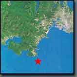
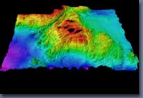
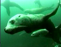
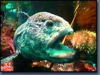

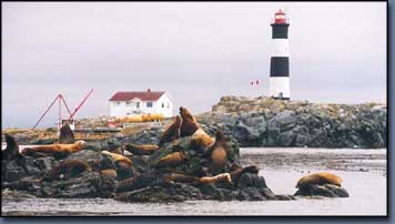
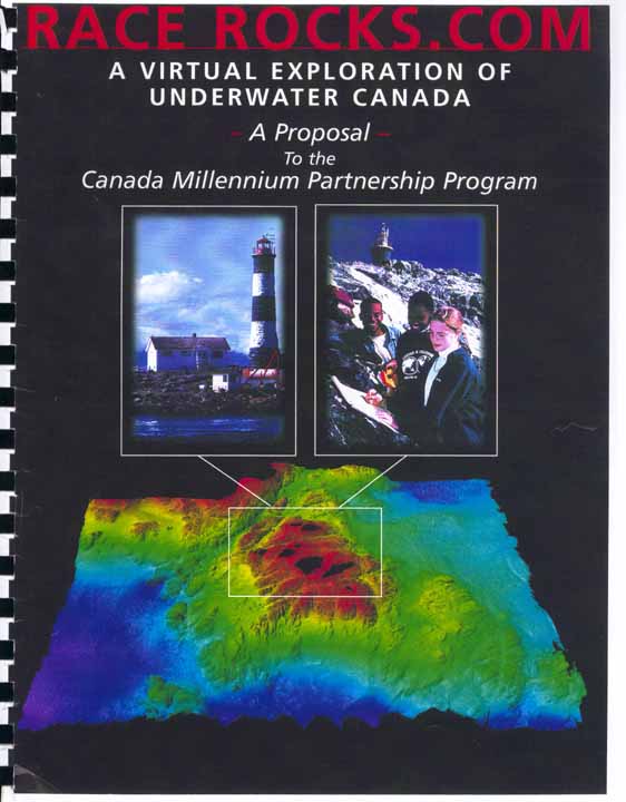
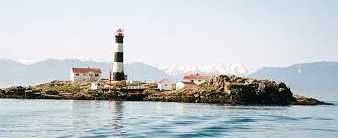
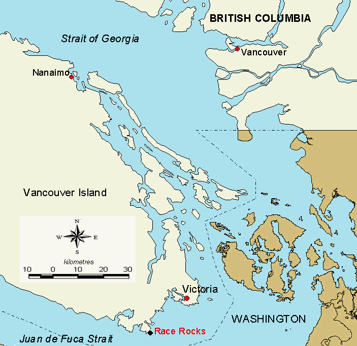
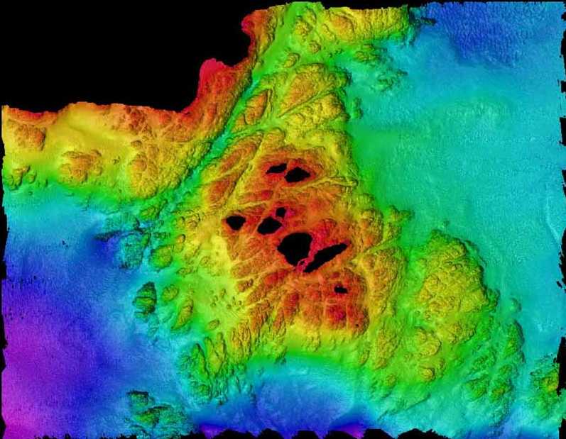
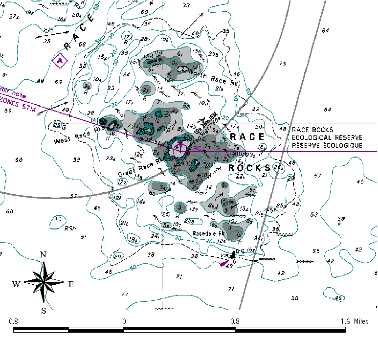
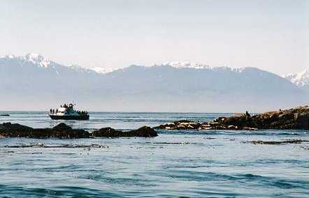
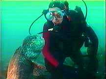

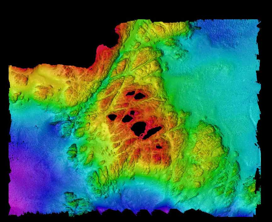
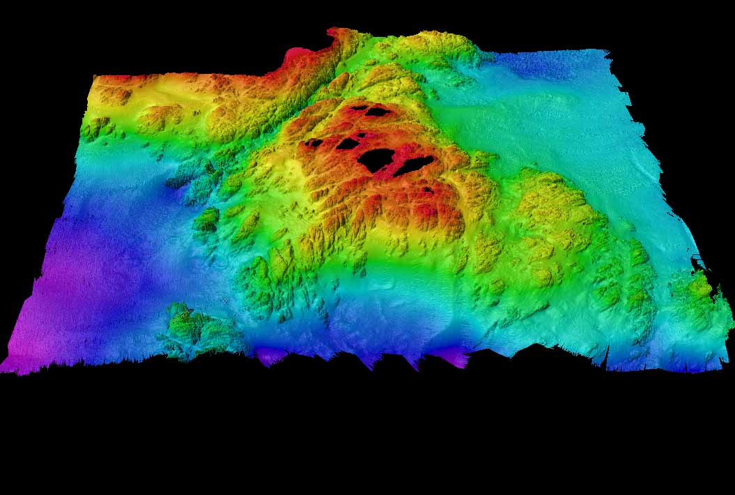
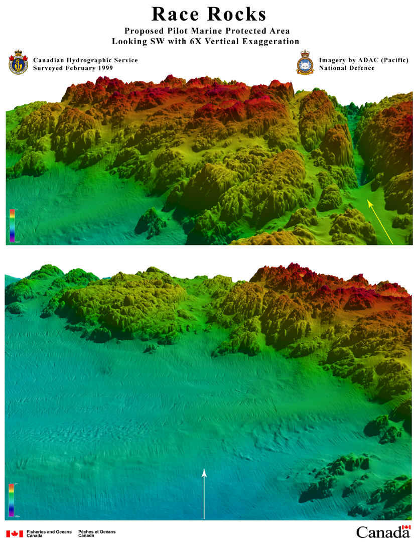