Rockfish Conservation Area at Race Rocks

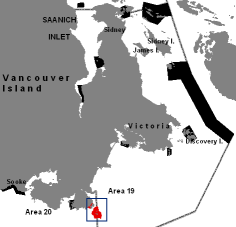
19_20cover_RCA_inset_RaceBentinckGeneral map of the Southern end of Vancouver Island. Race Rocks and Bentinck Island are in Area 19.

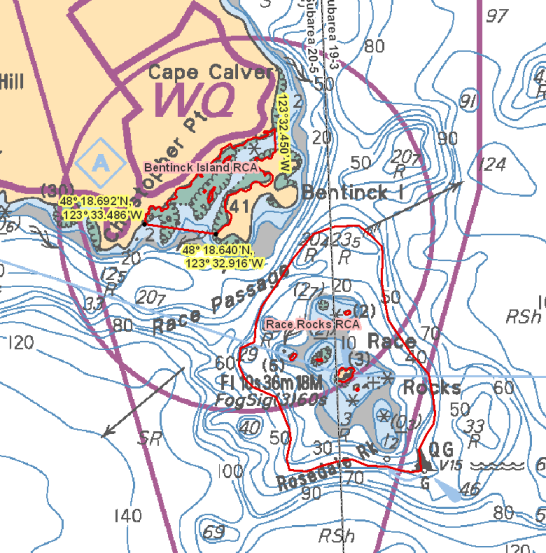
Bentinck Island – Chart 3461

Those waters of Eemdyk Passage in Subarea 20-5 that lie westerly of the meridian passing through 123°32.450’ west longitude and northerly of a line:

from 48°18.692’N 123°33.486’W
to 48°18.640’N 123°32.916’W

Race Rocks – Chart 3461

Those waters of Subareas 19-3 and 20-5 that lie inside the 40 metre contour line surrounding Great Race Rock and Rosedale Rock as shown on Chart No. 3461, published by the Canadian Hydrographic Service of the Department.

94_294_RaceRocksBentinck

Date modified by DFO:
Return to the Regulations for Race Rocks file  https://www.racerocks.ca/?p=8909

Race Rocks Lighthouse Great Race Island, British Columbia DFRP # 17447 Condition Assessment Including Indicative Cost Estimate: 2007

This document was prepared two years before  DFO actually did the upgrading of the light tower. The following quotes on the historic significance is worth noting.


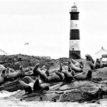
The Race Rocks tower is located on Great Race Island, a small and barren rock outcrop in the Strait of Juan de Fuca, about fifteen kilometres south of Victoria, British Columbia. Erected in 1860, simultaneously as Fisgard light, with which it was designed to function, the Race Rocks light tower is British Columbia’s second oldest operating lighthouse and a forerunner of the extensive system of navigational aids built during the following century along Canada’s West Coast.

Construction of both the Fisgard and Race Rocks towers was undertaken in 1859, at the initiative of colonial officials and with partial financial and technical support of the Imperial Government. The latter provided its expertise, the lighting apparatus, which according to the local legend, would have travelled from England with Fisgard’s first light keeper, and 7000 pounds in funding, half as a grant, half as a loan. The colonial government oversaw the selection of the site and the construction following a plan of combined tower and dwelling, attributed to both JohnWright of London and to the Surveyor General of British Columbia, Joseph Pemberton.1

  “Race Rocks light tower is “the only known example of tall, pre-Confederation, unsheathed stone masonry tower, built outside of Ontario”.2 Along with towers of a similar design on the Great Lakes, it shares the classification of “Imperial” tower, a reference to its typology as a tall, tapered, circular, pitched-faced stone structure, rather than to the British involvement in its construction. Unlike the Imperial towers of Ontario, however, the interior configuration of the Race Rocks lighthouse was based on its being attached to the keeper’s residence, and consists of a continuous stone spiral staircase rather than of superposed wooden floors linked by ladders.

The light at Race Rocks was lit on December 26, 1860, a month after that of the Fisgard tower. Until the construction of the landfall light at Carmanah Point in 1891, it was considered the most important lighthouse in British Columbia. It was attended to by a long succession of light keepers and their families, who lived in the attached stone residence until the construction of new dwellings in 1964, closely followed by the demolition of the original house in 1967.”

EXECUTIVE SUMMARY Background

race-rocks-towerThe Heritage Conservation Network (HCN) project team has completed the condition assessment and report for the Race Rocks Lighthouse located on Great Race Island in the Juan de Fuca Strait, south of Victoria, British Columbia, as part of the project for eighteen lighthouses for the Department of Fisheries and Oceans (DFO). The report contains structural and building envelope conditions, analysis of these conditions, recommendations and indicative cost estimates for mandatory and cyclical conservation work both in the short and the long term.

See the Full PDF at :Condition Assessment

Conservation Approach

This condition assessment, report and related recommendations, follow the conservation approach of minimal intervention and least harm to preserve/protect heritage character. This approach will help provide DFO with information required to properly manage the Race Rocks lighthouse while ensuring that the building is safe in terms of both public and staff and that the existing heritage fabric will be protected and maintained.

Description

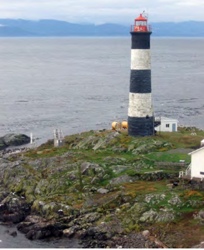
The Race Rocks Lighthouse is a pitched-face stone structure with a round, tapered shaft, painted with a series of horizontal black and white painted stripes. The tower corbels at the top forming a gallery around the cast iron lantern, which rises approximately 32 meters (105′-0″) tall from grade, and tapers from a diameter of approximately 5.8 meters at its base to 3.8 meters at its narrowest point below the gallery. The tower is accessible through a curved metalic stair and arched door opening, located 3.20 meters (10’6″) above grade. It is pierced with 4 window openings, the two lowest of which are arched and the top two, rectangular. The cast iron octagonal lantern, which sits atop the concrete parapet, can be reached by a continuous stone spiral staircase, which terminates just below it.

Heritage Value

The Race Rocks Lighthouse is a Recognized federal heritage building (FHBRO log number 90-85). It obtained a total score of 62, based on a score of 14 for historical associations, 23 for architecture, and 25 for environment. A review of the related Heritage Character Statement is provided in the report to help the lighthouse custodians identify and protect heritage fabric and aid in guiding future maintenance and repair interventions so as to maintain the lighthouse’s heritage value. This section identifies all of the elements of the lighthouse that are important in defining the overall heritage values that require protection. Its character-defining elements reside in its robust stonework construction consisting of large rusticated blocks with limited decorative detailing, typical of “Imperial” lighthouse design, in its black and white day marking and in the interior spiral stone stairway. Other buildings on the islands are considered to contribute to the heritage character of the tower’s environment, but were not investigated for this report.

PWGSC, P&TSM, Heritage Conservation Network 1

Race Rocks Lighthouse Condition Assessment Reports Victoria, British Columbia Including Indicative Cost Estimate

Methodology

Background and historical documentation were consulted both before and after the on-site investigation. This included a review of documents related to environmental site assessments in the preparation of the Site Specific Safety Plan prior to the site visit. The on-site investigation consisted of a preliminary site orientation by the team members to gain a general understanding of the building and its surroundings. Detailed visual and tactile investigations were then carried out on both the exterior and interior of the lighthouse. All investigations were non-destructive by nature and any samples were gathered from loose or fallen materials.

Assessment

Building Structure:
Overall, the stone walls from the foundations to the top of the tower were found to be in fair to poor condition. Although there are no signs of displacements or structural instability, extensive damage was observed. Two large vertical cracks extend vertically from the base of the tower to a height of approximately 10 meters and will require mapping and monitoring. Deterioration of the stone also included delamination and salt formation, mostly visible on the interior walls, at the top of the tower, corresponding to exterior areas that were covered in “gunite” several decades ago. Water appears to be trapped in the walls at that level and the stone masonry will require rapid treatment in the affected area to limit further decay. Extensive cleaning, repointing and renewal of the impervious coating will also be required throughout.

Lantern and Gallery:
Deferred maintenance of the lantern and gallery has lead to deterioration of surfaces, with paint chipping and corrosion of the cast iron lantern and paint failure and concrete spalling of the underlying parapet. The gallery also shows traces of surface deterioration, with decayed paint and a failing membrane.

Building Envelope:
With the exception of an opening obstructed with fog-detection equipment, windows and the access door were found to be in good condition overall. The main recommendation with regards to the building envelope concerns the improvement of ventilation and heating levels to help resolve the stone deterioration on the interior face of the walls. Ventilation may for instance be provided through the windows and door openings.

Other Building Elements:
The exterior stair is a recent addition to the structure and is in good condition overall. It may warrant replacement in the future for reasons of code compliance and enhancement of the structure’s heritage character.

2 PWGSC, P&TSM, Heritage Conservation Network

Race Rocks Lighthouse Condition Assessment Reports Victoria, British Columbia Including Indicative Cost Estimate

Recommendations

The principal recommendations for this condition assessment would include:

  • Examine and monitor the two vertical cracks at the base of the tower for a minimum of 1-2 years to verify if they are still active and identify their cause(s).
  • Remove the “gunite” coating from the top of the exterior walls using an appropriate method.
  • Clean, repair and repoint the stone on both interior and exterior faces of the tower.
  • Remove all paint on the interior of the tower, using an appropriate non-abrasive method.
  • Replace the existing impervious coating with a coating that allows circulation of water vapour and repaint the existing daymarking.
  • Remove and repair the cast iron lantern (workshop conservation).
  • Repair of the top of the parapet, at the base of the lantern.
  • Provision of additional ventilation and heating inside the tower.
  • Implement regular maintenance activities. A detailed list of recommendations, identifying the recommended short- or long-term time frame is provided by building element in Section 4.0 and by type (mandatory, cyclical, investigation). Further investigation into building elements that were not accessible, research, and monitoring of conditions will also be an important future activity.

    Cost Estimates

    The estimated cost for all recommended mandatory and cyclical work for the next twenty-five (25) years is $3,503,600. The corresponding Net Present Value (NPV) is $1,782,000.

    This amount corresponds to the sum (in NPV) of the mandatory generally short-term work $598,000, the cyclical generally long-term work $653,000 while also providing an allowance of $76,000 for further essential investigation, monitoring, and research, and $455,000 for overall fees, administration, etc.

    The cost estimates for a Five Year Operating and Maintenance Plan, as provided by DFO, are included in Appendix J.

Race Rocks Lighthouse Victoria, British Columbia

Condition Assessment Reports Including Indicative Cost Estimate

TABLE OF CONTENTS

EXECUTIVE SUMMARY ……………………………………………………………………………………………..1

1.0 INTRODUCTION………………………………………………………………………………………………..5

  1. 1.1  Background……………………………………………………………………………………………….5
  2. 1.2  Historic Context …………………………………………………………………………………………5
  3. 1.3  Conservation Approach ………………………………………………………………………………9
  4. 1.4  Project Team ……………………………………………………………………………………………11

2.0 LIGHTHOUSE DESCRIPTION…………………………………………………………………………12

  1. 2.1  Construction of the Lighthouse……………………………………………………………………12
  2. 2.2  Evolution of the Lighthouse ……………………………………………………………………….13

3.0 HERITAGE VALUE ………………………………………………………………………………………….17

4.0 CONDITION OBSERVATIONS, ASSESSMENT AND RECOMMENDATIONS …18

  1. 4.1  Methodology …………………………………………………………………………………………….18
  2. 4.2  Building Structure ……………………………………………………………………………………..19
    1. 4.2.1  Foundation …………………………………………………………………………………….19
    2. 4.2.2  Wall Structure ………………………………………………………………………………..24
    3. 4.2.3  Floor Structure and Interior Stair ………………………………………………………34
  3. 4.3  Lantern and Gallery ………………………………………………………………………………….38
  4. 4.4  Building Envelope …………………………………………………………………………………….46
    1. 4.4.1  Exterior Walls and Roof ………………………………………………………………….46
    2. 4.4.2  Windows……………………………………………………………………………………….49
    3. 4.4.3  Doors…………………………………………………………………………………………….52
  5. 4.5  Other Building Elements ……………………………………………………………………………54

5.0 ISSUES ANALYSIS …………………………………………………………………………………………..56

  1. 5.1  Health and Safety ………………………………………………………………………………………56
  2. 5.2  Protection of Heritage Character …………………………………………………………………56
  3. 5.3  Site-Specific Challenges to Future Planning Work ………………………………………..56
  4. 5.4  Materials Conservation Specialists Required ………………………………………………..57
  5. 5.5  Need for a Regular Maintenance Program ……………………………………………………58

6.0 URGENT WORK TO PROTECT THE PUBLIC AND STAFF …………………………..59

PWGSC, P&TSM, Heritage Conservation Network i

Race Rocks Lighthouse Condition Assessment Reports Victoria, British Columbia Including Indicative Cost Estimate

7.0 LONG-TERM CONSERVATION PROJECT PLAN AND
OPERATING AND MAINTENANCE PLAN
……………………………………………………..60

  1. 7.1  Urgent Work to Protect Heritage Character ………………………………………………….60
  2. 7.2  Recommendations for Further Investigation, Including Testing and Recording…60
  3. 7.3  Twenty-five Year Mandatory and Cyclical Long-term Repairs/Replacements ….61
  4. 7.4  Five Y ear Operating and Maintenance Plan ………………………………………………….63
  5. 7.5  Schedule…………………………………………………………………………………………………..63

8.0 COST ESTIMATES …………………………………………………………………………………………..64

  1. 8.1  Twenty-five Year Project Plan ……………………………………………………………………65
  2. 8.2  Five Year Operating & Maintenance Plan…………………………………………………….66
  3. 8.3  Demolition Option and Due Diligence …………………………………………………………66

APPENDIX A: APPENDIX B: APPENDIX C: APPENDIX D: APPENDIX E: APPENDIX F: APPENDIX G: APPENDIX H: APPENDIX I: APPENDIX J:

Reference Documents ……………………………………………………………………….. A-1

FHBRO Heritage Character Statement, Score and Building Report ……B-1

The Stone Tower………………………………………………………………………………..C-1

Supplementary Chronology of Historical Information ………………………. D-1

Archival Drawings……………………………………………………………………………..E-1

Executive Summaries of Environmental Assessment Reports……………… F-1

Site Specific Safety Plan ……………………………………………………………………. G-1

Field Observations……………………………………………………………………………. H-1

Detailed Cost Table for all Recommendations ……………………………………..I-1

Five Year Operating and Maintenance Plan ………………………………………..J-1

See the Full PDF at :Condition Assessment

February 2007 : Restoration needed for the Imperial tower of at Race Rocks

These pictures were taken before restoration of the Race Rocks Lighthouse in 2009-2010

Historic TowerThe Times Colonist ran an article on the problems of the deterioration of the heritage light tower at Race Rocks.Jack Knox and Deborah Brash pay a visit to the tower at the end of January 2007. The following article appears in the Times Colonist.


A beacon of hope for Race Rocks
Carney tries again to win protection for prize lighthouses now withering away, Jack Knox, Times Colonist, Tuesday, Feb. 06, 2007.

The Condition at RR
February, 2007
inside tower inside tower
stairs
Inside the tower, on the way up the stairs, the walls become pockmarked with condensation blisters Near the fog sensor, which is set into a south facing window, moisture has caused the wall surface to crumble The flaking is extensive in the top third of the tower When the stairs are not swept, there is a continual rain of sand and paint chips.
inside tower
inside tower inside tower
Near the window where the counterweight is stationed, the crumbling is particularly obvious. Looking downstaters at the same window. The yellow flag denotes the top of the stairs. Even the inside of the lantern room has condensation from the windows loosening the painted surface.The light in the foreground is state of the art in low energy consumption. Outside at the base of the windows, caulking has deteriorated, allowing driving rains to send moisture inside.
metal straps
cracked window
Wherever iron is exposed, rusting and deterioration sets in.. this is at the base of one of the windows in the lantern room. Moisture builds up even behind recent painting. The metal straps underneath the lantern room which help to anchor the top in place are rusted and partly detached from the decaying sandstone wall. A crack in the lantern room window apparently appeared years ago when the Coast guard was doing blasting for construction on the island
Cracks on Tower
corroded railing
Crack width on tower
Sept15, 2007
Corrosion of steel on railing around lantern room, Sept. 2007

Fortunately in 2009-2010 , DFO restored the tower. See this page with pictures taken by the Ecoguardian Ryan Murphy

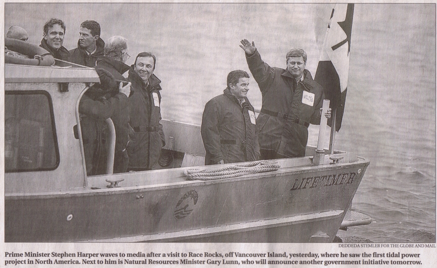
Prime Minister Stephen Harper Visits Pearson College and Race Rocks

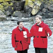
ecoenergyOn January 19 2007,Prime Minister Stephen Harper and two federal cabinet ministers, Gary Lunn and John Baird pose with Glenn Darou beside a scale model of the energy generating turbine installed at Race Rocks in September of 2006.


A number of other news media covered this event:

atdockB.C. critical for Tory majority, Harper says Peter O’Neil, Vancouver Sun; Files from CanWest News Service Published: Saturday, January 20, 2007
“OTTAWA — Prime Minister Stephen Harper, on Vancouver Island Friday to announce $1.5 billion for renewable energy initiatives, said B.C. is “critical” to his hopes of winning a majority government….” 
Harper was in Metchosin, near Victoria, to unveil an environmental incentive package in which the Conservatives will spend $1.5 billion over 10 years to boost Canada’s supply of wind, ocean, solar and other green energy. He said the package will boost the production of renewable energy by 4,000 megawatts a year. “In terms of greenhouse gas reductions, that’s the equivalent of taking one million cars off the road,” he said.

harperPutting ‘green’ toward going green Edward Hill, Peninsula News Review Jan 24 2007
….”Prime Minister Stephen Harper announced a $1.5 billion funding package for clean green energy generation Friday at Lester B. Pearson College in Metchosin, the host of North America’s first operational tidal turbine.
Coined the ecoEnergy Renewable Initiative, $1.48 billion over 10 years has been earmarked toward helping industry harness renewable, zero or low emission energy sources, such as wind, solar, tidal, wave, biomass or small hydro………”
PM to Boost Funding for Tidal Power… trip to Metchosin will heighten new Tory support for alternate energy Peter O’Neil, and Richard Watts, Times Colonist; CanWest News Service Published: Friday, January 19, 2007


harper3Harper pledges $1.5 billion for green energy, Global National,CanWest News Service, Saturday, January 20, 2007METCHOSIN, B.C. — The Conservative government will spend $1.5 billion over 10 years to boost Canada’s supplies of wind, tidal and other green energy, Prime Minister Stephen Harper announced Friday…..”In terms of greenhouse gas reductions, that’s the equivalent of taking one million cars off the road,” he said. “That is real, practical, achievable action on climate change.”


harplunnTories’ green boost to cost $1.5 billion..at Pearson College, Harper unveils incentives to ramp up wind,tidal and solar power.. Lindsay Kines.. Times Colonist, Victoria British Columbia, Saturday, January 20, 2007..page A1. “The Conservative government will spend $1.5 billion over 10 years to boost Canada’s supply of wind,ocean,solar,and other green energy, Prime Minister Stephen Harper said yesterday.”


pollPoll: Tories gain in B.C.  Prime Minister Stephen Harper said B.C. is “critical” to his hopes of winning a majority government while he was at Lester B. Pearson College of the Pacific yesterday in Metchosin to announce $1.5 billion for renewable energy initiatives,—-Public aware of initiatives his party is taking to protect environment, PM says.. Peter O’Neil..Times Colonist, Victoria British Columbia, Saturday, January 20, 2007..page A3.


Creating Power to Stay in Power, Conservatives are out to prove that their plan is better than the Liberal one. Les Leyne, Times Colonist , January 20, 2007, page A16.. “What a lot of trouble Prime minister Harper went to in order to announce a rather obscure alternative energy program that he Liberals unveiled earlier is going to carry on under his government. By plane, by motorcade and by water taxi he made his way almost literally to the ends of the Earth to illuminate the point that…..” (see full article.).

Tories announce $1.5-billion renewable energy plan, CBCnews “Harper said a 10-year incentive program, the so-called ecoEnergy Renewable Initiative, will be established to fund eligible projects to be constructed over the next four years.”

Harper nips some green from Liberals: wind, tidal and biomass projects benefit from new Tory program ..Rod Mickleburgh , Metchosin BC. and Bill Curry, Ottawa. The Globe and Mail Saturday, January 20, 2007, page A4 “Stephen Harper’s government is finding it easy to be green, resurrecting yesterday a frozen Liberal alternative-energy program, injecting it with a bit more “oomph” and trumpeting it as the Tories’ own. The ecoEnergy Renewable Initiative pledges to spend $1.5-billion over the next 10 years to increase Canada’s supply of emission-free power from renewable, alternative energy sources such as wind, the ocean and biomass. The program aims to produce enough renewable energy to reduce greenhouse-gas emissions equivalent to taking one million cars off the road, Mr. Harper said.”(enlarge picture)

glensRacerocks Tidal Project : Former Shell Executive wants to make a difference. Lindsay Kines , Times Colonist, January 22, 2007. page A3 ” ” Its very hard for someone to go out to Race Rocks and not come away saying: “this stuff is great!” …By the end of the year, Clean Current expects to complete design work on a three megawatt commercial turbine with manufacturing slated to start in 2008. …. “(See full article.)

See Video by Clean Current

Lessons from Marine Protected Areas and Integrated Ocean Management Initiatives in Canada

From:
http://www.zoology.ubc.ca/courses/bio416/MPAs_Canada.pdf

Coastal Management, 35:51–78, 2007
Copyright © Taylor & Francis Group, LLC
ISSN: 0892-0753 print / 1521-0421 online
DOI: 10.1080/10.1080/08920750600970578

SYLVIE GUENETTE ´
JACKIE ALDER
Fisheries Centre
University of British Columbia
Vancouver, BC, Canada
and
Centre for Coastal Studies and Continuing Studies in Science
Simon Fraser University
Burnaby BC V5A 1S6

Abstract: There is a wave of interest in Marine Protected Areas (MPA) and Integrated Management (IM) as tools for addressing declines in marine environments through ecosystem-based management.

Lessons learned from seven MPA and two IM initiatives in Canada show
how engaging stakeholders results in: building and maintaining momentum through
social capital; using the collective knowledge of stakeholders; consensus through
formal and informal rules; and developing leadership capacity. However, as the number
of issues or the number of stakeholders increases—especially where fisheries are
involved—time, resources, and challenges in gaining support and participation increase.
Political and administrative obstacles and resistance to change still constitute much of
the challenge. Finally, funding and political commitment must be allocated from the
start; otherwise momentum stops and it is hard to regain even when funding becomes
available.

The following excerpt is a case study of Race Rocks:

Racerockspart1 Racerockspart2

History of the Klallam Name for Race Rocks

xwayenmThis word written in the Klallam language means “fast flowing water”, the area around Race Rocks. The late Thomas Charles of Beecher Bay First Nations provided this name in March of 1999. It was transcribed from the word written out in Klallam by his wife Flora Charles .(See details below)

We are grateful to Burt and Lee Charles, the late Thomas Charles, Tom Sampson, Andy Thomas, Vern Jacks, and Earle Claxton who have helped us to understand how important the coastal waters and Race Rocks are to the Salish people and their culture. We believe we started on a fruitful path in involving local First Nations people in the educational program at the Race Rocks MPA. This will allow us all to better understand the science and conservation principles practiced for generations on this coast.
rrlogocolxwmMuch of what we are now doing at Race Rocks and the surrounding area is not new. For countless generations Sooke Basin, Beecher Bay and Pedder Bay provided shelter and ideal locations for First nation communities. The great wealth of sea-life provided generous opportunity for harvesting of foods and medicines. Careful conservation techniques, passed down through the generations ensured the resources were managed in a truly sustainable manner, at least until the arrival of the Europeans. On Tom Sampson’s advice, we suggest you read the Bamberton Report which provides considerable detail of the cultural dependence that First Nations people have on the land and the coastal areas of the Salish Sea. Tom sees the report as a valuable model for the way we should respect the knowledge of First Nations people when we create plans for managing protected areas.

For more than just the most recent millennia, people lived and worked as an integral part of the coastal ecosystems of Southern Vancouver Island and the Strait of Juan de Fuca. They managed the resources for their own survival. They valued the land and the water ecosystems because they did not see themselves as separate from those systems. Place names were important since only through the language can one understand the importance of natural areas to the First Nations people.

earlinvertsOn a visit to Race Rocks with Tom, Andy and Vern, we were told of the way their people would use the gull eggs in a sustainable way so that they would always have some for later. The sea urchins were also a special food. Their power was such that only those of a certain age could eat them, as the eggs were too strong for the younger people. Sea cucumbers had their top end cut off, were cleaned out and then stuffed with other kinds of food. Mussels and barnacles as well as the myriad of snails, whelks, chitons and other intertidal invertebrates were standard fare for the people. The area also provided a wealth of the standard fish resources. Often seafood that was collected was traded with the interior people from Washington, as far as the South end of Puget Sound.

In early1999 the Marine Protected Area Advisory Board indicated that we would like to acknowledge First Nations traditional use of the Race Rocks MPA with a name in the local Coast Salish Language.

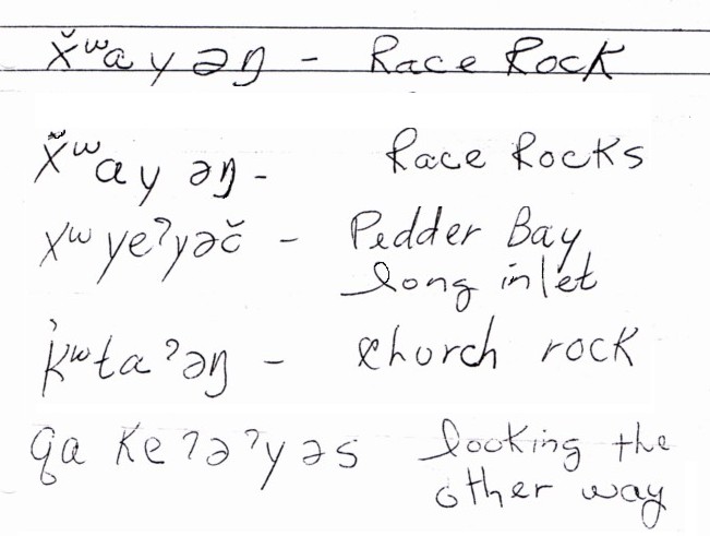
In March of 1999, Tom Samson and Angus Matthews visited one of the oldest Klallum-speaking elders, the late Tom Charles and his wife Flora who were living then in Beecher Bay. He asked them if they could help to provide the place names for the area and a name for the Race Rocks MPA. Thomas had strong memories of the traditional ways. (Sadly, Thomas Charles passed away in December of 1999.) In his discussion with Tom Samson, he recorded some of the place names of this corner of Vancouver Island and gave a sense of how their ancestors lived within the ecosystem. Location and language is so important to them when talking about culture. The late Flora Charles wrote down the words that the late Tom Charles spoke in Klallum so that the Advisory Board would be able to use them. This is a copy of the words Flora Charles wrote out for the Advisory Board. The area from Pedder Bay to Beecher Bay was a community that was totally dependent on the coastal resources well into the twentieth century. Race Rocks was known as xwayenthe area in which one could get any kind of food they needed. Thomas Charles remembered his parents going to sell ling cod from Race Rocks the area of “Xwayen” (the word written in the Klallum language means “fast flowing water” to the buyer in Pedder Bay, “Whoayinch” in the 1920’s. Church Island, visible from Race Rocks out in front of Beecher Bay was ” Kquitong”, the Raven’s hang out.
See spelling in Klallam below:

They recorded the conversation, and Flora Charles wrote down the Klallam spellings shown in her handwriting below. An audio casette of this conversation is included in the Pearson College librarytcharles
 

Canada’s Federal Marine Protected Areas Strategy, 2005

Table of Contents

ExecutiveSummary ……………………………………………..3 Protecting Our Marine Environment. . . . . . . . . . . . . . . . . . . . . . . . . . . . . . . . . . . . . . . . . . 4 A Time for Action . . . . . . . . . . . . . . . . . . . . . . . . . . . . . . . . . . . . . . . . . . . . . . . . . . . . . . . 6 BuildingaNetwork–AnInnovativeApproach ……………………………7 BenefitsofaMarineProtectedAreasNetwork ……………………………8 International Agreements and Commitments. . . . . . . . . . . . . . . . . . . . . . . . . . . . . . . . . . . 9 Linkages to Federal Initiatives . . . . . . . . . . . . . . . . . . . . . . . . . . . . . . . . . . . . . . . . . . . . . 10 Guiding Principles for Implementation . . . . . . . . . . . . . . . . . . . . . . . . . . . . . . . . . . . . . . . 10 The Strategic Framework . . . . . . . . . . . . . . . . . . . . . . . . . . . . . . . . . . . . . . . . . . . . . . . . 12

Appendix 1 – Federal Tools for Establishing and Managing
Marine Protected Areas . . . . . . . . . . . . . . . . . . . . . . . . . . . . . . . . . . . . . . . . . . . . . . 14

Appendix 2 – Roles and Responsibilities of Other Government
Departments in Marine Protected Areas (MPA) Establishment and Management. . . . 17

Appendix 3 – The Federal Approach to Building a Network
of Marine Protected Areas . . . . . . . . . . . . . . . . . . . . . . . . . . . . . . . . . . . . . . . . . . . . 18

See the Full PDF :2005canadasmarineproareastrategy

Executive Summary

Around the world, marine protected areas are increasingly being endorsed as a valuable conserva- tion and protection tool. The benefits of a network of marine protected areas are numerous, diverse and include ecological, social, economic and cultural elements. The drive for a Federal Marine Protected Areas Strategy ensued from the need for a coopera- tive and collaborative approach to the development of a network of federal marine protected areas in Canada as a means to help address the declining health of our oceans. In 1997, the Oceans Act pro- vided Fisheries and Oceans Canada with a leading and coordinating role in this endeavor.

The intent of this Strategy is to clarify the roles and responsibilities of federal departments and agencies with marine protected area mandates, namely Fisheries and Oceans Canada, Environment Canada

In support of this goal, this Strategy will aim to fulfill its objectives to:

• establish a more systematic approach to marine protected area planning and establishment;

• enhance collaboration for management and monitoring of marine protected areas;

• increase awareness, understanding and participa- tion of Canadians in the marine protected area network; and

• link Canada’s network of marine protected areas to continental and global networks.

These objectives, and the Strategy’s supporting activities, are a shared responsibility of Fisheries and Oceans Canada, Environment Canada and the Parks Canada Agency. Together, the departments and agencies will work towards meeting these objectives. To ensure that progress on the
network continues, the above mentioned federal departments and agencies will move forward in

and the Parks Canada Agency, and to describe how federal marine protected area programs can collectively be used to create a cohesive and com- plementary network of marine protected areas.

The establishment of a network of marine protected areas, established and managed within an integrated oceans management framework, that contributes to the health of Canada’s oceans and marine environments.

In support of this goal, this Strategy will aim to fulfill its objectives to:

• establish a more systematic approach to marine protected area planning and establishment;

• enhance collaboration for management and monitoring of marine protected areas;

• increase awareness, understanding and participa- tion of Canadians in the marine protected area network; and

• link Canada’s network of marine protected areas to continental and global networks.

These objectives, and the Strategy’s supporting

activities, are a shared responsibility of Fisheries and Oceans Canada, Environment Canada and the Parks Canada Agency. Together, the departments and agencies will work towards meeting these objectives. To ensure that progress on the
network continues, the above mentioned federal departments and agencies will move forward in establishing areas that have previously been identi-

fied as candidate sites. In addition, the Strategy outlines how collective planning efforts will be undertaken to identify a suite of sites that may

be added to the network in the future.

See the FULL PDF:


Posted in MPA

Cooperative management of marine protected areas, the First Nations view: Lessons learned from the Race Rocks Area of Interest.

This pdf is from: Recommendations for Effective Marine  Planning Processes
Lessons Learned from Case Studies in Canada, the USA
and Australia:

see PDF: wwf_northwestatlantic_recommendationsforeffectivemarineplanning

 Living Oceans Society
and World Wildlife Fund Canada
January 2005

See page 16-117 for : Cooperative management of marine protected areas, the First Nations view: Lessons learned from the Race Rocks Area of Interest.


Links to MPA Archived and Current Resources

Aside

Archives of 1999 to 2002 and 2009-2011 Race Rocks MPA Advisory Board Documents
Sept 2009-2010 Race Rocks MPA Advisory Board resources.
  • Marine Protected areas in Canada- Implications for both conservation and fisheries management, C.S Jamieson and C.O.Levings 2001
    Abstract: Legislated marine “protected” areas are now widely distributed throughout tropical and temperate waters, but the nature of human activities actually restricted in any area varies. This ambiguity about what “protected” means hasresulted in contradictory claims as to both the benefits and costs of marine protected areas. Here, we give our perspective on the current status of marine resource protection in Canada in general and British Columbia in particular. We first describe and discuss the history of Canadian marine protected areas established to date. Many areas are claimed to be protected, with little understanding by either the general public or even most marine resource experts as to what human activities are actually regulated by legislative designations. Second, we present an overview of biological reasons and objectives for marine protected areas, followed by a review of both the conservation and fisheries management effects and implications resulting from effective renewable resource protection. Finally, we propose a unique qualitative scheme for classifying and describing marine protected areas of different types to determine relative measures of protection.
  • Marine Protected Areas: An Essential Element of the Fisheries Management Toolbox
    François Côté, Jessica Finney, Science and Technology Division 24 April 2006
    “Introduction :
    The urgent need to improve protection and management of marine areas is becoming more and more apparent as the number and status of many important fish stocks continue to deteriorate. It has become evident that the vast majority of attempts to manage fisheries resources in a sustainable fashion have been unsuccessful, and resource managers are beginning to seek alternatives to traditional management strategies. Marine protected areas (MPAs) are viewed as important tools in reducing the risks associated with current fisheries management practices. MPAs are areas of ocean that are protected from various human activities.(1) Canada has taken initial steps to ensure that MPAs will complement existing measures to conserve and protect fisheries resources. In fact, the establishment of a national network of MPAs is one of the main components of the federal oceans management strategy outlined in Part II of the 1997 Oceans Act.(2) By all accounts, however, progress has been slow.This paper provides an overview of some of the background theory behind creating and managing effective MPAs, and looks at how these areas are being used as part of Canada’s oceans and fisheries management strategy. ” Can. J. Fish. Aquat. Sci. 58: 138–156 (2001)
  • Out of Sight, Out of Mind and Almost out of Time
    Towards an effective System of Marine Protected Areas in BC
    A brief to the Sierra Club of BC by Scott Wallace and David R. Boyd April 2000 (PDF)
  • Developing a Collaborative Process to Establish Marine Protected Areas , Marc Pakenham
    Fisheries and Oceans Canada In: Puget Sound Research ’01. Puget Sound Water Quality Action Team, Olympia, WA
    .XwaYeN (Race Rocks), as Canada’s first Ocean Act MPA, was recommended for designation based on a series of recommendations that were developed through a collaborative process. This process had a numberof distinctive features and quite remarkable results. Was the process based on authority or interests? How do you bring a disparate spectrum of interests together to establish consensus-based recommendations for conservation and protection? As a case study, the XwaYeN experience offered many lessons and has encouraged a wide range of interests to describe their own process and vision for further MPA designations.
ARCHIVAL PAGES: Some no longer available on Government websites.
  • Conservation of Marine Ecosystems ( CANADA) by the NRTEE) ,
    Below is a quote from Chapter 9 of a report on Securing Canada’s Natural Capital.
    “9.2 Key challenges

    One of the most significant barriers to advancing marine conservation in Canada is the extent to which responsibility for protecting marine habitat is fragmented and spread among various agencies and jurisdictions. Within the federal government alone there are more than 35 pieces of legislation and at least 25 agencies concerned with marine management. In addition, although the federal government has primary jurisdiction over the oceans and the continental shelf, authority for some portions of the coastal zone is shared by the federal government with provinces and territories. This has resulted in confusion, duplication of effort and protracted delays in making decisions that affect ocean users.
    There is also a lack of coordination within the federal government. Although Fisheries and Oceans Canada has a mandate under the Oceans Act to coordinate the efforts of the three federal agencies that can establish MPAs—Fisheries and Oceans Canada, Parks Canada and Environment Canada—there is no comprehensive federal approach to MPAs. Fisheries and Oceans Canada has taken a “learning by doing” approach to Oceans Act MPAs, by identifying a series of pilot Oceans Act MPA sites on Canada’s coasts. Parks Canada has developed a systems plan based on 29 marine regions but has not identified specific sites for all of them, and Environment Canada has yet to identify the sites that would complete its marine system of national and marine wildlife areas. The lack of a coordinated national plan for MPAs has led to uncertainty among resource users that in some cases has translated into fear and diminished support for conservation initiatives.A third major challenge is our limited knowledge of the oceans compared with what is known about the land. For example, decision makers have extremely limited knowledge about the seabed and the habitat it provides for key species. In essence, we do not know enough about the underwater topography of important marine habitats to manage them effectively. Much of the bottom of Canada’s oceans is mapped at only a very rough scale and, even though ecosystem management requires an understanding of marine food webs, many of the links between marine species are not well understood. ” end of quote
BILL C-10: AN ACT RESPECTING THE NATIONAL MARINE CONSERVATION AREAS OF CANADA  Canada National Marine Conservation Areas Act The Bill received Royal Assent on June 13, 2002 — exactly 4 yrs and 2 days after it was first tabled in the House of Commons. It is now an Act of Parliament .
OCEANS Regulation and Legislation in Canada
Report: Marine Reserves Key to Preserving Ocean Ecosystems
(01/14/2003)
In his report prepared for the Pew Oceans Commission, Dr. Stephen Palumbi of Stanford University finds that fully protected marine reserves are an effective tool for restoring and maintaining coastal and marine habitats. Marine Reserves: A Tool for Ecosystem Management and Conservation describes how intensive loss of coastal habitat, pollution, commercial fishing, recreational fishing, and tourism can degrade marine ecosystems, and presents a crucial role for marine reserves in ocean management.


MPA news International News and Analysis of Marine Protected Areas