January 31 2024 is the deadline for public submission of comments on The Draft Framework on Bodiversity and Ecosystem Health.
For an understanding of the differences in the many ecosystems in British Columbia and an appreciation of where Race Rocks Ecological Reserve fits in the classification, I have found this good description of Ecoregions and Ecosystems which includes a reference to Race Rocks, and the small percentage of the Ecosection in which it lies that is protected.
The Evergreen Alliance has produced an important document detailing the current state of protected areas in British Columbia. In the BC Government’s new emphasis on the value of preserving Biodiversity and Ecosystem Integrity, it is interesting to note what percent of various ecoregions of British Columbia are in need of protection to meet the 30X30 goal .
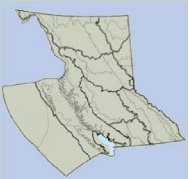
The Georgia Puget-basin Ecoregion
From: An Introduction to the Ecoregions of British Columbia
In the OVERVIEW, There is a good definition of Ecosections:
“The Ecoregion Classification System was first adopted by the Ministry of Environment in 1985 to serve as a framework for recognizing small scale ecosystems in British Columbia. The Ecoregion Classification helps us to understand and to depict the great habitat diversity of the province. Since 1985, the Ecoregion Classification has been revised five times to reflect more detailed mapping. The fourth revision Ecoregion units was mapped at 1:250,000 using Landsat, topographic, Biogeoclimatic and marine ecosystem information, while the fifth revision has been mapped based on the earlier concepts plus detailed vegetation zonation mapping. The most current digital (GIS) database is Version 2.1 2006, but the supporting reports and descriptions is the third edition 2011. The Ecoregion Classification system is used to stratify British Columbia’s terrestrial and marine ecosystem complexity into discrete geographical units at five levels. The two highest levels, Ecodomains and Ecodivisions, are very broad and place British Columbia globally. The three lowest levels, Ecoprovinces, Ecoregions and Ecosections are progressively more detailed and narrow in scope and relate segments of the Province to one another. They describe areas of similar climate, physiography, oceanography, hydrology, vegetation and wildlife potential. Within each terrestrial ecoregion, climatic zones occur where specific soils, plant and animal communities and aquatic systems develop because of the interaction of climate with the land surface and surficial materials. These zones are best defined within the Biogeoclimatic Ecosystem Classification system. Ecological zones in marine ecosystems are products of temperature, salinity, sea-bed configuration and water depth. The Marine Ecoregion Classification system should be used to define the marine ecosystems. Each ecosystem is ultimately identified by sampling individual sites. At the lowest level in an ecosystem classification, attention is directed to specific parameters, such as topography, surficial materials, soil development, moisture regime, microclimate, floristics, succession, productivity and animal use. Ecoregions should be thought of as ‘big picture’ ecosystems. As such the province should be viewed first for its big, all-inclusive landscape chunks, then progressively through more detailed levels, and finally each area of the province has to be viewed with other classifications or the underlying geographical detail. The boundaries between units must be thought of in the same way, broad lines for small scale ecosystems progressing to greater precision for the larger scale ecosystems. For convenience, however, one boundary is used to define all ecosystem levels, from Ecodomain down through to the Biogeoclimatic or marine unit level……….
Ecoprovince Subdivisions
From page 47: The Georgia Depression Ecoprovince in British Columbia is subdivided into four ecoregions containing seven ecosections (One of those is a marine ecoregion and three are marine ecosections)…………
on page 53 there is a description of the GEB – Georgia Basin Marine Ecoregion: In British Columbia this marine ecoregion contains two marine ecosections.
• GEB – Georgia Basin Marine Ecoregion: In British Columbia this marine ecoregion contains two marine ecosections. o SOG – Strait of Georgia Marine Ecosection: This is a broad relatively shallow, semienclosed estuarine basin that separates southern Vancouver Island from the mainland. It is mainly marine waters, but it also contains several islands. The islands have very dry mild climates, such as southern Quadra, Cortes, Texada, Lasqueti, Denman and Hornby islands. The southern islands and lower portion of Texada Island area dominated by the dry Coastal Douglas-fir Zone, whereas the northern islands and the upper portion of An Introduction to the Ecoregions of British Columbia 54 Texada Island are dominated by the very dry maritime variant of the Coastal Western Hemlock Zone. The marine environment is dominated by the intertidal, nearshore, epipelagic and mesopelagic zones.
JOS – Strait of Juan de Fuca Marine Ecosection: This a deep trough marine area with a strong “estuary-like” outflow current. It is the major water exchange conduit between the Georgia – Puget Basin Ecoregion and the open Pacific Ocean. Except for a few islets, such as Race Rocks, most of the ecosection is marine waters. The northern and southern boundaries approximate the outer limit of the nearshore zone; while the eastern boundary in British Columbia is south of Chain Islets & Discovery Island; in Washington it is south of the San Juan Islands and east of Whidbey Island. The southern deep-sea marine portion of Pacific Rim National Park – West Coast Trail Unit occurs in the far northwest portion of this ecosection. ”
In the Juan de Fuca Strait Ecosection there is .01 % of the protected areas in BC, and 5.57 percentage of the area is protected.
| Juan de Fuca Strait | 0.01 | 5.57 | GPB |