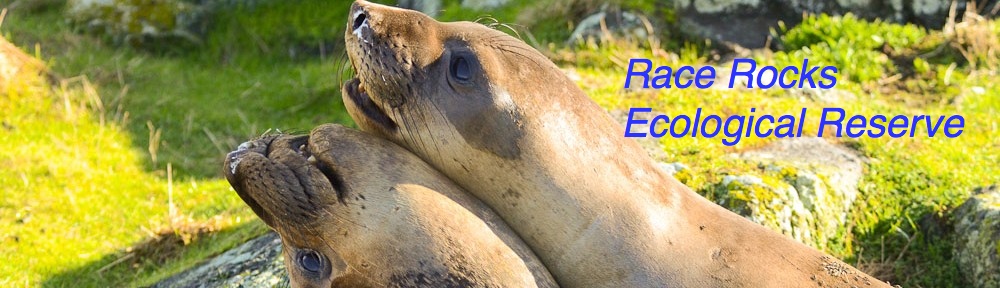
The Diving Service Schools Project 1999
 Link to our 1997-98 season of the Diving Service Schools Project.
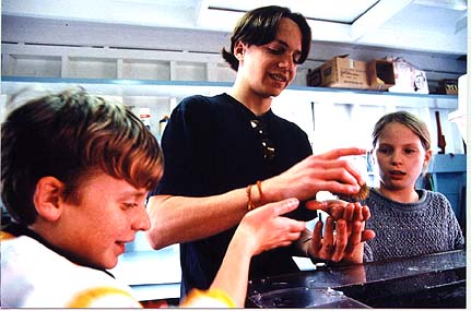
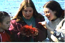
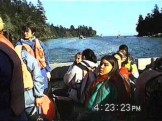
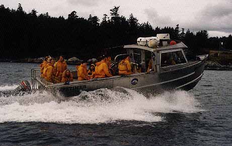
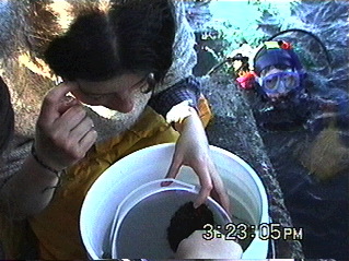
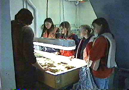
| In the spring term, 1999, the students of the Diving Service took groups of grade 7 students from the Sooke school district on field trips to the Marine Protected Area of Race Rocks Ecological Reserve.
|
||||||||||||||||||||||||
GOALS OF THE DIVING SERVICE SCHOOLS PROGRAM:
In order to make the experience more enjoyable and informative for everyone, we suggest that the students do some research before coming on the field lab. It would make things more interesting if they could get a basic familiarity with some of the possible species in the different phylums which they will be seeing at Race Rocks.
|
Color Polymorphism in the Intertidal Snail Littorina sitkana at Race Rocks
Patterns of Color Polymorphism in the Intertidal Snail Littorina sitkana in the Race Rocks Marine Protected Area.

- Figure 1 In Fig. 1 the snails were purposely placed on the white quartz substrate to show the contrast between a shell of color 27 ( white ) and some of colors 1 – 10 ( Black to grey ).
- Figure 2 The same process was repeated in Fig. 2 below only on black, basaltic substrate adjacent in the same tidepool. (Note three black snails (color 1-10) in lower left hand corner.)
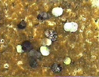
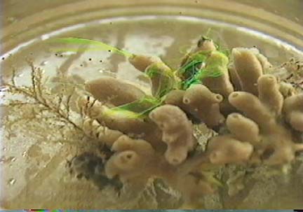
- In Figure 3. Several colors of snail can be seen grazing on the golden diatoms in Pool 4 in the spring of 1998.
Extended Essay done by: Giovanni Rosso, Lester Pearson College, 1998 .
The complete version of the research is available in the Library at the college.
Abstract:
As with most intertidal gastropods, Littorina sitkana shows remarkable variations in shell color. This occurs both in microhabitats which are exposed or sheltered from wave action. There seemed to be a close link between the shell coloration of the periwinkle and the color of the background substrate. Field work was carried out on the Race Rocks Marine Protected Area in order to investigate patterns of color polymorphism. Evidence from previous studies was used to support interpretations and understand certain behaviors.
The results showed that in the study site there was a very strong relation between the shades of the shells and the colors of the rocks. Light colored shells stayed on light shaded rocks and vice versa. An interesting pattern was noticed with the white morphs. These were rare along the coast
(only 2%), but were present in relatively high numbers in tidepools of white quartz. From previous experience (Ron J.Etter,1988), these morphs seem to have developed as evolutionary response a higher resistance to physiological stress from drastic temperature changes between tides. Some results showed that the white morph is present in an unexpectedly high percentage at the juvenile stage, but then their number decreases dramatically. As in Etter’s study more research needs to be made on the role visual predators have in this phenomenon.
ROSSO, Giovanni Edoardo 0034 -083
Patterns of Color Polymorphism in the Intertidal Snail Littorina littorea at
the Race Rocks Marine Protected Area.
AN EXTENDED ESSAY PREPARED FOR THE INTERNATIONAL BACCALAUREATE
Candidate number: 0034 – 083 February 1999
Name: Rosso, Giovanni Edoardo
Best language: Italian
School: Lester B. Pearson College of the Pacific
Subject: Environmental Systems
Supervisor: Mr. Garry Fletcher
Table of contents:
Abstract ————————————————————— 3
Introduction ———————————————————- 4
Materials and methods ———————————————- 5
Data analysis ———————————————————- 7
Conclusion ———————————————————– 12
Observations ——————————————————— 13
Evaluation ———————————————————— 16
Suggestions for further studies ———————————— 16
Acknowledgments ——- ——————————————- 18
Literature cited —————————————————— 18
Appendix ————————————————————- 19
2
Abstract:
As most intertidal gastropods, the Littorina littorea shows remarkable variation in shell color. This occurs in both microhabitats that are exposed or sheltered from wave action. There appeared to be a close link between the shell coloration of the periwinkle and the color of the background surface. Fieldwork was carried out at the Race Rocks Marine Protected Area in order to investigate patterns of color polymorphism. Evidence from previous studies was also taken into account to better support interpretations and understand certain behaviors.
The results showed that in the study site there was a very strong relation between the color of the shells and the color of the rocks. Light colored shells lived on light shaded rocks and vice versa. An interesting pattern was noticed on the white morphs. These were rare along the coast (Only 2%), but were present in relatively high numbers in tidepools set in white quartz. From previous experience (Ron J Etter, 1988 ), these morphs seem to have developed, as an evolutionary response, a higher resistance to physiological stress from drastic temperature changes between tides. Some results showed that the white morph is present in an unexpectedly high percentage at the juvenile stage, but then their number decreases dramatically with age. As in Etter’s study, more research needs to be done on the role of visual predators in this phenomenon.
3
Introduction:
There is strong evidence to prove that intertidal gastropods are highly polymorphic for shell coloration (Ron J Etter, 1987). Even within a single species it is not uncommon to find considerable shell color variation in a single trait (Laurie Burham, 1988 ). In the genus Littorina the color of the shell often appears to be parallel to the one of the background (Heller, 1975; Smith, 1976; Reimehen, 1979; Hughes and Mather, 1986 ). Nevertheless the causes and patterns of color polymorphism. in intertidal gastropods are still a fairly unexplored field. Many paths have been undertaken to make some light upon these obscure areas. The most common interpretation was always the presence of visual predators (Ron J Etter, 1987) like birds and fish. Others investigated on the effects of the shells diets. But more recent studies ( Rowland, 1976; Ossborne, 1977; Berry, 1983 ; Etter, unpubl. ) have shown that diet virtually does not affect the shell coloration, although the intensity of pigmentation might be slightly altered. Finally, physiological stress has been introduced as a possible cause color polymorphism. A very interesting study, made by Ron J. Etter on the intertidal snail Nucella Lapillus, shows how the white coloration suffers much less from temperature variations in dry micro habitats as opposed to the brown morphs. With his work he gave some revolutionary insights on the distribution of the shells according to their color.
In my fieldwork I chose to disprove the null hypothesis that there is no link between the color of the periwinkle and the color of the substrate it is living on. In order to do this I sampled a great quantity of empty shells and scaled their color from I to 27. 1 then chose five rocky coastal areas, each of a different shade. I analyzed the color of the live shells on each of the chosen rocks, scaled them according to their color and then graphed the results. I also observed the young shells in the inside of barnacles and took notice of their color frequencies in relation to their quantity. I ended my study looking in some tide pools and recording new surprising results. I concluded that:
I roughly calculated that between one station and the other there was a change in tide level of 13 cm. I therefore kept this in account and lowered the quadrat accordingly into the water.
Data analysis-
Rock – 1 (Black)
The rock contained a creek were I noticed a very high density of periwinkles in a very limited area. In the inside of the creek they were almost piled and glued on top of each other. With the help of a pen I extracted them and laid them on a white sheet of paper. Once I accomplished the process of identification I put them back. I noticed that the bigger shells (10 to 14 mm wide) were located on top of the smaller ones (3 to 6 mm wide). This made me think that the bigger ones wanted to protect the smaller ones from swells and predators. It actually does work as a protection system, but it surely is not because of the kind nature of periwinkles. It is obviously a matter of physical size.
Rock #1 -Shade #1
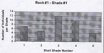
From the graph we see that the black rock hosted the darkest shades, from 1 to 5. The average number of individuals per shade is 7.6. The average shell color is 3.
7
Rock # 2- Dark grey
As opposed to the previous case the surface of rock # 2 was rather flat. Population was regularly distributed. All shells seemed to be above 5 mm in width. Here I had the opportunity to understand the great resistance that periwinkles have to salinity changes. In fact some of the shells were located under the flow of a fresh water pipe. It might have been a coincidence but these shells were slightly bigger (7 to 12mm wide).
Rock #2 – Shade 2
. 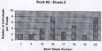
The graph shows that there are some exceptions (Color 1, 3) to the trend that has been shown in the previous graph. I guessed that these are the cases of lucky shells that have not jet been seen by birds or fish. The average number of individuals per shade is 4.25 . The average shell color is 13.6 .
Rock – 3 (Brownish red)
The reddish color of the rock came from many small algae that covered its surface. I did not notice any irregular patterns in distribution. The shells seemed to be above 5 mm in width.
8
The background color was parallel to the shade of the periwinkles. Color 1 and 20 appear to be exceptions: only three individuals in total. The average number of individuals per shade is 4.4 . The average shell color is 9.4.
Rock – 4 (Light brown)
Rock #3 -Shade 3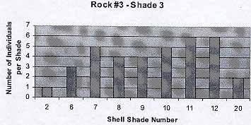
The surface of the rock was very irregular.. Some areas were covered with dead barnacles ( Balanus sp. ). I noticed that here the shells were smaller in size and they tended to be gathered around the barnacles. Nevertheless I repeated the process.
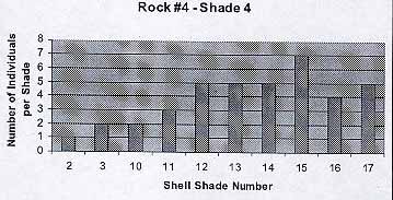
Rock #4 -Shade 4
9
The population reflects the previous trends. The average number of individuals per shade is 3.8. The average shell color is 11.3.
Rock – 5 (White rock with dark patches)
This rock was one of the most interesting ones. In fact, the two different shades of the rock gave place to a particular phenomenon that clearly disproved the null hypothesis. I tried to be as precise as I could in distinguishing the shells on the white and dark spots. I noticed the net distinction between the color polymorphism on the two areas.
Rock #5 -Shade 5
In the light patches the average number of individuals was 4.3. The average shell color was 23. In the dark areas the average number of individuals was 4.8. The average shell color was 3.
If the color of the shell would be directly proportional to the one of the rock, the average shell colors would be:
Ideal Model
10
Rock 1
| 3 | |
| Rock 2 | 13 |
| Rock 3 | 8 |
| Rock 4 | 18.5 |
| Rock 5 | 24.5 / 3 |
Actual Model
In the actual experiment the averages were:
Rock 1
| 7.6 | |
| Rock 2 | 13.6 |
| Rock 3 | 9.4 |
| Rock 4 | 11.3 |
| Rock 5 | 23 / 4.8 |
I assume that the dark grey rock is actually lighter than the brownish red
one. If we observe the results we understand that that:
| Rock Number Actual Shade |
Ideal One | Error | |
| 1 | 7.6 | 3 | 4.6 |
| 2 | 13.6 | 13 | 0.6 |
| 3 | 9.4 | 8 | 1.4 |
| 4 | 11.3 | 18.5 | 7.2 |
| 5 | 23 / 4.8 | 24.5 / 3 | 1 / 1.8 |
Considering that a minority of the shell color numbers was far away from the average: the average error is of 2.8. This means that on average the actual color was 2.8 units away from the ideal one, therefore disproving the null hypothesis. (Chi square test was used to verify the results.)
11
Conclusions:
The data analysis clearly shows that in the Race Rocks area there is a very strong relation between the color of the shell and the color of the background they are standing on. The shells with light shades are found on light colored rocks. The same relation is true also for the opposite extreme case were we find black shells on black rocks.
I feel that the model we can create from this experience is relevant above all because the consequences of human presence are reduced to very low levels. In fact, I have been operating in a Marine Protected Area were not many people go. The area is relatively free both from water and air pollution. The only predators are the natural ones. Besides this, the ecosystem is intact and the populations of all the organisms are at almost climax level. The amount of visual predators includes crabs, sea gulls, black oystercatchers, pigeon guillmonts, otters and fish.
From the observations made (p. 13, second part) on the entirely white morphs, we may deduce that there is a strong link between what Ron J. Etter found out on the Nucella lapillus and the Littorina littorea. Putting the pieces of the puzzle together we notice that the distribution of periwinkles is obviously affected by numerous reasons. There seems to be a wide color gap between the shades 1 to 26 and 27. The first twenty-six, when wet, are not very different from each other. The white morph instead is clearly identifiable both when it is wet or dry. If we keep in account that the vast majority of the coastal area on Race Rocks is dark, obviously it will be easier to for shells 1 to 26 hide. The white shells instead have such a great disadvantage that only 2% survive. Keeping in account Etter’s results we may conclude that, excluding a minority of extraordinary circumstances, all these deaths are caused by predators. In fact, when the juvenile periwinkles leave the barnacles, their shell is still soft. Now, if the white periwinkles are born near an area of white surface, then their chances of being seen decrease and actual groupings of white shells may be noticed. The color of their shell also allows them to bare physiological stress much better than the darker shades. The stress comes from the drastic changes in temperature between tide variations. In the case of the Nucella lapillus, in Etter’s experiment, the white shells inhabited most of the sheltered areas and, as previously mentioned, dry areas. This could also apply to the Littorina littorea, but on the Race Rocks Island the sheltered areas are very few and the number of predators is high. The white quartz is the only substrate that can host them (once they leave the Balanus sp.). I feel that if the ocean conditions were not as rough and there would be fewer
12
predators, the white morphs would also be seen on the darker rocks. In the tide pool both the white morph and the dark one live together The mortality of the last though is obviously higher, both for predation and stress (Ron J Etter).
In the dark areas the presence of the white morph is almost nonexistent (2%). But the shells belonging to shades 1 to 26 are distributed according to a remarkable pattern. On light colored rocks we will find shells that belong to the high numbers. In the opposite case the same trend applies. – In the area I took in exam this close relation is probably emphasized by the high intensity of predation. The contrasts are easily spotted and eliminated. Therefore, in the absence of predators, I think that the darker shells would be able to live on any color surface. Of course the dark population would suffer more in the dry areas as opposed to the lower levels.
Observations:
As I was watching the newborn shells (about 1 mm wide) in the dead barnacles I found out that the presence of white shells is unexpectedly high at this stage. I tried counting them and recording the results. On average a dead 20-mm wide Balanus sp. holds between four and eight shells of Littorina littorea. I analyzed ten samples in two different areas and recorded the number of white juvenile shells:
Area
| Total number of shells | Number of white shells | |
| 1 | 5 | 2 |
| 6 | 2 | |
| 8 | 4 | |
| 4 | 3 | |
| 4 | 1 | |
| 5 | 3 | |
| 6 | 4 | |
| 7 | 3 | |
| 6 | 2 | |
| 8 | 5 | |
| 2 | 4 | 2 |
| 7 | 4 | |
| 8 | 5 | |
| 3 | 0 | |
| 5 | 3 | |
| 7 | 4 | |
| 8 | 4 | |
| 6 | 3 | |
| 4 | 3 | |
| 9 | 5 |
In the first area the average Balanus sp. held 5.9 periwinkles and 2.9
were white or very light colored. The percentage of white shell was of 49.
In the second area the average Balanus sp. held 6.1 periwinkles and
3.3 were white. The percentage of white shells was of 54.
The results show that on average 51.5% of the shells are white. If we
make an exception for the tidepools, the percentage of white shells present
on the protected coastal areas is 2 (This is an approximate calculation made
when collecting the dead samples and when counting the live ones). This
means that 49.5% are eaten or die before reaching a sufficient size to move
in an area where they would be protected by the background they are
standing on. According to the study made by Ron J. Etter on the intertidal
snail, Nucella lapillus, when the brown morphs and the white ones were put
on the same exposed coastal area, there were virtually no differences in the
mortality rates of the two. If we dare to make a parallel between the two
species, it would be therefore wrong to assume that the white morphs die
because of natural causes such as diseases or disadaptation. It is my opinion
that literally 49.5% of the white morphs is victims of visual predators
because they can easily be seen before reaching an area where they would
camouflage. In this case, I am not including tide pools with white bottom
and where the water is shallow. I am referring to the morph with shade 27,
which is not common along the coast probably because of the lack of
almost entirely white rocks.
On the other hand I mentioned tied pools because of a specific reason. In
fact, on the Southwestern part of the island there are six tide pools, each
with different depths and different consequent bottom coloration. During
the days of the experiment this area was inaccessible for the presence of
about 75 California sea lions and about 23 Stellar. Nevertheless, in previous
visits to the island for other reasons (the reserve is in fact managed by
Pearson College and is used for several academic programs, projects and
environmentally oriented diving) I had the opportunity to observe the
presence in tide pool – 4 of about 20 entirely white shells of Littorina littorea
standing on white quartz. This had originated a question that had long
14
remained without an answer. Why can the white periwinkles be found only in this tide pool (if we exclude the two- percent I was talking about before)? The most common explanation was based on the presence of certain minerals, difficult predation and a genetic mutation that occurred only there. To be honest, after coming across Ron J. Etters study on the Nucella Lapillus, it was hard for me not to relate the two cases.. In his study he states that the white morph heats up at a lower rate as opposed to the brown morph in shallow and protected areas. Observing a higher rate of mortality (not due to predation) in the brown morph, he deduced that the white morph had developed a better defense mechanism against physiological stress. It therefore has higher chances of survival in very shallow water or in those areas that remain exposed between tides for a long time. Although brown snails can avoid exposure to the sun by moving to more shaded and moist microenvironments, Etter thinks their greater susceptibility to stress nonetheless puts them at a disadvantage by limiting their foraging area and increasing the amount of time that they must spend in hiding- This in turn could lead to slower growth rates and reduced levels of fecundity (Laurie Burnham, Scientific American, September 1988 ). On the other hand this does not exclude the presence of natural predators, especially in young age.
If we compare these results to the observations made on Race Rocks we may find many points in common. Especially after I had a new confirmation. In fact, in a tide pool with difficult access in another part of the island I found a similar behavior. On a small area of white quartz I found five entirely white periwinkles. There is a big difference in size between the ones I found there and the population of tide pool – 4. The first ones were about 2-3 mm wide; the second ones were 6-12mm. This might be due to the fact that they were living in a creek of difficult access to most predators. Nevertheless the pattern fits: the white periwinkles are almost all found in areas of shallow water or that remain exposed for a long time between the action of tides. On the other hand these are the only areas were white quartz is found on the island. The observations made on the fieldwork make me almost certain that the reasons for the white morphs to be in the tide pools are an adaptation to physiological stress and a perfect camouflage. In Etters experiment most of the protected areas were inhabited by white morphs. On Race Rocks only two tide pools contained such organisms and in very low quantities. I think this can be explained by the combination of several factors. In the first place the ocean conditions around the island are
15
very rough and they make it hard for the shells to survive in all areas.. In the second place there is very limited quantities of white rock were the shells can camouflage. Finally the very high quantity of visual predators, both from the air and form the sea, make it very difficult for these shells to move around because they will immediately be seen.
Evaluation:
Due to the lack of hi-tech material I had to verify my observations with simple tools- This forced me to use other people’s previous studies (Ron J. Etter) to better understand what I saw. If I had disposed of an instrument to measure the internal temperature of the shells I could have repeated Etters experiment on the Littorina littorea.
My experiments allow the creation of a model that is true, as far as we know, only on the Race Rocks Marine Protected Area. Other generalizations should be verified. In order to obtain a more reliable model the experiment should be repeated over a longer period of time on a regular basis. The month of October is a period when there is a significant increase in predation also due to the fact that the colony of seagulls on the island is incremented by the newborn.
I chose a vast scale of shade variations in order to achieve more precise results. By doing this, it was hard for me to identify exactly to which number each shell belonged. Even though I tried my best I might have made some mistakes.
Knowing that there are significant differences in distribution between the exposed and the sheltered areas, each of the sites was not exposed to the same environmental conditions. Some were more exposed to currents than others.
Suggestions for further studies:
As I mentioned in the introduction the causes and patterns of color polymorphism in intertidal gastropods are a fairly unexplored field. There are therefore still many grey areas that need to be cleared.
The fieldwork I had the opportunity to make on Race Rocks allowed me to learned many things on these fascinating creatures, but posed also many questions to which I have no answer.
I was surprised when I found so many white periwinkles in the barnacles. It would be interesting to find out exactly what happens to them once they leave these shells:
Who exactly are their predators?
16
At which stage in growth does their shell become too hard to be digested?
How do they choose the areas where they stop?
Are there certain types of minerals that create better conditions for living? Is there a link at all?
What is the exact probability for a shell to be white at birth?
Is the gene universal or is it majority- present in certain areas?
How does the alimentation affect growth and reproduction rate?
The white shells are more tolerant to physiological stress, but does this affect the immunitary system? Which diseases are the most common?
The fieldwork I have done seems to apply for Race Rocks, but is it true also in other nearby areas? To what extent does the exposure to rough environmental conditions affect distribution? Since the tide pool was covered and surrounded by sea lions, it was obviously affected by their waste products. The population of periwinkles seems to be fairly stable? How tolerant are these shells to changes in pH? Is there a difference between the degree of tolerance of the dark and the white morphs?
17
Acknowledgments
I sincerely thank my supervisor, Mr. Garry Fletcher, for his encouragement, support, precious advise and constructive criticism. I am also very grateful to Mr. Mike and Miss. Carol Slater for hosting me on the island during the field work. I will never forget the delicious supper we had together on Thanksgiving Day. In the end, I would like to thank Mr. Chris Blondeau for his sincere interest and for bringing me at Race Rocks by boat.
Literature cited:
Laurie Burnaham, September 1988, The hard shell, pp.26-27, Scientific American.
Ron J. Etter, April 1987, Physiological stress and color polymorphism in the
intertidal snail Nucella Lapillus, Museum of comparative zoology, Harvard
University, Cambrige, MA 02138.
Jane M. Hughes and Peter B. Mather, December 1984, Evidence for predation as a
factor in determining shell colorfrequencies in a Mangrove snail Littorina Sp.,
School ofAustralian Environmental Studies, Griffith University, Nathan,
Queensland,Australia.
18
APPENDIX 1. Photographs of Littorina littorea
In Fig. 1 the snails were purposely placed on the white quartz substrate to show the contrast
between a shell of color 27 (white) and some of colors
1 – 10 ( Black to grey).
The same process was repeated in Fig. 2 below only on black, basaltic substrate adjacent in the
same tidepool. (Note three black snails (color 1-10) in lower left hand corner.)
Figure 1 Figure 2
19
Apendix 2. Photographs of the shell shades of Littorina littorea
There was a very significant difference in color between the dry and the wet shells. In the two pictures some of the shells had to be moved around in order to maintain the darker periwinkles before the lighter ones. For example, wet shell number 11 had to be moved to 9 on the dry scale
20
Appendix 3. Picture from Ron J. Etters fieldwork
Ron J. Etter noticed that in the Nucella Lapillus the white morph was more common in the sheltered areas. The brown one dominated in the areas of wave exposure. He concluded that the color of sea shells on the seashore may be an evolutionary response to physiological stress.
The color of seashells on the seashore may be an evolutionary response to physiological stress
Photographs of Littorina sitkana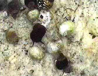 Figure 1
In Fig. 1 the snails were purposely placed on the white quartz substrate to show the contrast between a shell of color 27 ( white ) and some of colors 1 – 10 ( Black to grey ).
The same process was repeated in Fig. 2 below only on black, basaltic substrate adjacent in the same tidepool. (Note three black snails (color 1-10) in lower left hand corner.)
 Figure 2
 In Figure 3. Several colors of snail can be seen grazing on the golden diatoms in Pool 4 in the spring of 1998.
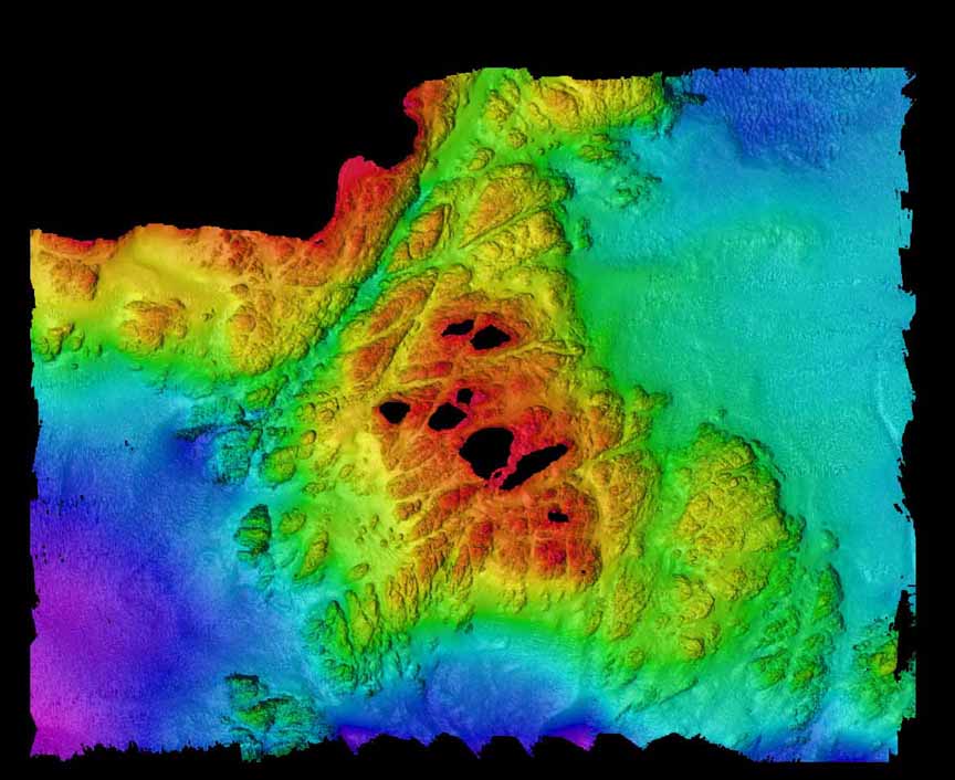
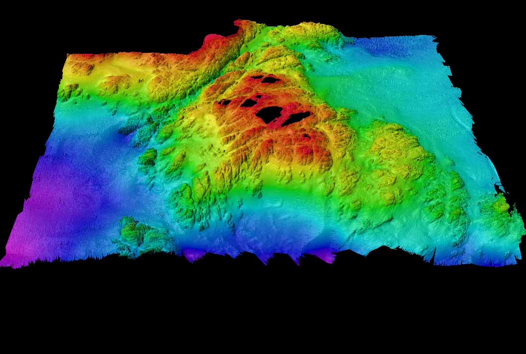
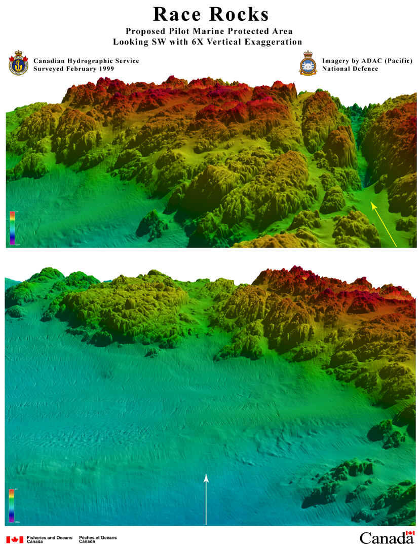
ACOUSTICAL BATHYMETRY OF RACE ROCKS
ACOUSTICAL BATHYMETRY OF RACE ROCKS
|
||

Pelican in reserve
Chris relief.
16:40 pelican seen on West side of a great race. 14:00 2 explosions on Bentinck island scared birds and sea lions off the rocks.
Wednesday – December 9,8:20 Pelikan observed on east side.
Abalone tagging at Race Rocks with Pearson College Divers
In 1998, we began a long term research program, initiated by Dr. Scott Wallace, on the population dynamics of the Northern Abalone
(Haliotis kamtschatkana). For several years, the Pearson College divers monitored the population. In this video, Pearson College graduate Jim Palardy (PC yr.25) explains the process.
Race Rocks Announced as One of Canada’s First Marine Protected Area Pilots Sept. 1, 1998
 Canada became the first country in the world to adopt its own Oceans Act in 1997. In it there were constructive plans for the designation of Marine Protected Areas |
|
NEWS RELEASE: Race Rocks Announced as One of Canada’s
First Marine Protected Area Pilots Sept. 1, 1998 |
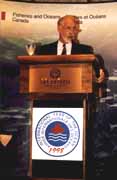 “Today at 1:30 pm. in Victoria, BC at a luncheon in the Empress Hotel in conjunction with the Coastal Zone Canada ‘ 98 Conference, The Honourable David Anderson , Minister of Fisheries and Oceans for Canada announced that Race Rocks and Gabriola Passage will become the first two Marine Protected Areas for the Pacific Coast of Canada. The minister emphasized that this was an historic occasion as it represents the first steps of many in creating these special areas for the conservation of marine resources. The two areas will serve as “Pilot MPA’s ” and represent the first of several areas to be designated in the three oceans of Canada. On hand for the announcement by the minister was Garry Fletcher, faculty member in biology and environmental systems at Lester Pearson College, along with many invited guests from the aboriginal communities, environmental groups, provincial government officials, and other stake holders in the marine environment of British Columbia.” (click on picture for the complete speech.) “Today at 1:30 pm. in Victoria, BC at a luncheon in the Empress Hotel in conjunction with the Coastal Zone Canada ‘ 98 Conference, The Honourable David Anderson , Minister of Fisheries and Oceans for Canada announced that Race Rocks and Gabriola Passage will become the first two Marine Protected Areas for the Pacific Coast of Canada. The minister emphasized that this was an historic occasion as it represents the first steps of many in creating these special areas for the conservation of marine resources. The two areas will serve as “Pilot MPA’s ” and represent the first of several areas to be designated in the three oceans of Canada. On hand for the announcement by the minister was Garry Fletcher, faculty member in biology and environmental systems at Lester Pearson College, along with many invited guests from the aboriginal communities, environmental groups, provincial government officials, and other stake holders in the marine environment of British Columbia.” (click on picture for the complete speech.)In the ensuing months, negotiations will take place with the ministry in order to set up the parameters of these new Marine Protected Area pilot study areas. |
| DFO BACKGROUNDER: RACE ROCKS – XwaYeN A Success Story for Community and Stakeholder Involvement- Sept 14 2000 |
 In January of 1999, as part of the requirements of the Marine Protected Areas Pilot review process, Garry Fletcher was contracted by Fisheries and Oceans Canada to complete The Race Rocks Ecological Overview. An MS Access metadatabase of all the relevant Race Rocks ecological information was assembled . This database and accompanying references and audiovisual material are now available in the library at Lester B. Pearson College. In January of 1999, as part of the requirements of the Marine Protected Areas Pilot review process, Garry Fletcher was contracted by Fisheries and Oceans Canada to complete The Race Rocks Ecological Overview. An MS Access metadatabase of all the relevant Race Rocks ecological information was assembled . This database and accompanying references and audiovisual material are now available in the library at Lester B. Pearson College.
Go to the Proceedings of this workshop. Official designation of Race Rocks as Canadas first Marine Protected Area |
| RACE ROCKS ADVISORY BOARDIn this index , you will find a complete set of references to the proceedings of meetings of the advisory board, the proposal sent to Ottawa and the subsequent disappointing Gazetted version which alienated First Nations, leading to the final ratification of MPA satus being put on hold. |
Marine Protected Areas A Strategy for Canada’s Pacific Coast
Marine Protected Areas
A Strategy for Canada’s Pacific Coast
Marine protected areas are a vital part of our commitment to sustainable economies, viable coastal communities, and a healthy, diverse marine environment. Our goals are to protect and conserve the natural beauty and richness of our marine areas, to maintain ecological diversity, and to preserve the many recreational, natural and cultural features of our Pacific coastline for all time.
DISCUSSION PAPER August 1998
A Joint Initiative of the Governments of Canada and British Columbia
Foreword
On behalf of the governments of Canada and British Columbia we are pleased to present this discussion paper, “Marine Protected Areas, A Strategy for Canada’s Pacific Coast“. The Pacific coast of Canada is one of the most diverse and productive marine environments in the world – we rely on it in many ways, as a source of food,employment, recreation and spiritual renewal. We want to build and protect this richness for present and future generations. Our commitment to a Marine Protected Areas Strategy isa key piece of the foundation for this goal.
This Strategy has been developed jointly by federal and provincial agencies and clearly reflects the need for governments to work in unison to achieve common marine protectionand conservation goals. The Strategy is not a new program, but an initiative to coordinate all existing federal and provincial marine protected areas programs under a singleumbrella. This will allow for the development of a national system of marine protected areas on the Pacific coast by the year 2010 which is interlinked with the marine componentof the B.C. Protected Areas Strategy.
This discussion paper reflects extensive advice and feedback from our resource agency staff, as well as local governments, First Nations, and community, stakeholder andindustry perspectives. We now want to provide all marine interests and users an opportunity to review and comment further on the Strategy.
We are pleased that Canada and British Columbia are able to release this paper in 1998-the International Year of the Ocean. The success of conserving and protecting naturalmarine areas is a shared responsibility, we look forward to working with you to complete a “Marine Protected Areas Strategy for Canada’s Pacific Coast“.
Signed by Donna Petrachenko (Director-General, Pacific Region – Department of Fisheries and Oceans) Co-chair, MPA Strategy Steering Committee
Signed by Derek Thompson (Assistant Deputy Minister – British Columbia Land Use Coordination Office) Co-chair, MPA Strategy Steering Committee
Table of Contents
Foreword
1.0 Introduction
2.0 What are Marine Protected Areas
3.0 The Need to Create Marine Protected Areas
4.0 Vision and Objectives for a Marine Protected Areas Strategy
5.0 Developing a System of Marine Protected Areas
6.0 Your Feedback on the Strategy
Appendix A: Principal Participating Agencies in the Development of the Marine Protected AreasStrategy
Appendix B: Federal and Provincial Statutory Powers for Protecting Marine Areas
1.0 Introduction
The Pacific coast is host to a multitude of ecological, social, cultural and economic values which provide benefits and opportunities for all who have the good fortune to enjoyour spectacularly beautiful maritime coastline. Few people know that our coast is also among the most biologically productive in the world and continues to generate tremendouswealth for British Columbians and Canadians.
We have recognized that the sustainability of the world’s oceans is increasingly becoming a critical concern to coastal nations. The need to maintain the health andvitality of our marine resource base, together with broad ranging global issues such as continued urbanization of coastal areas, pollution, habitat alteration and loss, and overexploitation, are key concerns. These problems and opportunities are fueling our desire to establish a system of marine protected areas along the Pacific coast of Canada as oneessential tool to address the needs of our oceans.
The MPA Strategy proposes three important elements:
- A joint federal-provincial approach: All relevant federal and provincial agencies will work collaboratively to exercise their authorities to protect marine areas.
- Shared decision-making with the public: Commits government agencies to employ an inclusive, shared decision-making process with marine stakeholders, First Nations, coastal communities, and the public.
- Building a comprehensive system: Seeks to build an extensive system of protected areas by the year 2010 through a series of coastal planning processes.
The benefits of marine protected areas are many, and include:
- contributing to the protection of the structure, function and integrity of ecosystems;
- encouraging expansion of our knowledge and understanding of marine systems;
- enhancing non-consumptive and sustainable activities; and,
- improving the health of our ocean resources.
A total of 104 marine protected areas on the Pacific coast have already beenestablished. These were put into place using a variety of legislative tools and they consist predominantly of relatively small marine parks, ecological reserves and wildlifemanagement areas created to meet specific conservation and recreation needs. In the past, the need to work in collaboration to reach mutual goals was not apparent, and the majorityof protected areas were created by individual federal and provincial agencies operating on their own.
Central to this Strategy are a number of coastal planning processes which would be undertaken by governments over time throughout six major coastal regions (see Section5.2). These planning processes are inclusive and collaborative, in order to involve everyone with an active interest and to ensure that general and specific uses of coastaland marine areas, including Marine Protected Areas, are addressed.
For example, as part of the coordinated planning approach, Canada and B.C. signed an agreement in 1995 called the Pacific Marine Heritage Legacy (PMHL), which has as itscentral vision the creation of a system of marine and coastal protected areas along the entire Pacific coast. The current focus of the PMHL is the acquisition of land in thesouthern Gulf Islands and the consideration of a complementary Marine Conservation Area in the Gulf Islands’ encompassing waters.
To date, a federal-provincial government Working Group and senior management Steering Committee have been working to develop this Strategy discussion paper. However, broaderpublic involvement and acceptance is needed and will be essential to the success of the Strategy. This paper provides readers with an overview of the proposed Strategy andinvites comments. Section 6.0 in particular poses specific questions to which we are seeking your comments.
2.0 What are Marine Protected Areas
“Marine protected areas” are sites in tidal waters that enjoy some level of protection within their respective jurisdictions, although internationally the term may bedefined and interpreted quite differently from jurisdiction to jurisdiction. For example, the World Conservation Union uses it as a generic label for protected marine areas such assanctuaries, parks, reserves, harvest refugia and harvest replenishment areas. Under the new Canada Oceans Act, Fisheries and Oceans Canada has authority to formally designate Marine Protected Areas, however, in this discussion paper, we have agreed to usethe term broadly to describe all the federal and provincial designations that protect marine environments.
Sidebar #1: What are Marine Protected Areas
Marine Protected Areas could include:
-unique coastal inlets, bays or channels;
-representative marine areas;
-boat havens with important anchorages;
-marine-oriented wilderness areas;
-cultural heritage features;
-critical spawning locations and estuaries;
-species-specific harvesting refugia;
-foraging areas for seabird colonies;
-summer feeding and nursery grounds for whales;
-offshore sea mounts or hydrothermal seavents; and
-a host of other special marine environments and features.
Regardless of the particular designation, all marine protected areas (MPAs) under the Strategy would:
1. Be defined in law
The legal authority to establish an MPA will derive from one of several federal and provincial statutes including: Canada’s Oceans Act, Fisheries Act, National Parks Act, Canada Wildlife Act, Migratory Birds Convention Act, or proposed Marine Conservation Areas Act; and British Columbia’s Ecological Reserve Act, Park Act, Wildlife Act or Environment and Land Use Act.
2. Protect all or a portion of the elements within a particular marine environment
The federal and provincial governments have differing and, at times, overlapping jurisdiction in marine areas. Depending upon the statute under which an MPA is created,the area may comprise any combination of the overlying waters, the seabed and underlying subsoil, associated flora and fauna, and historical and cultural features.
3. Ensure Minimum Protection Standards
All MPAs would share Minimum Protection Standards prohibiting:
- ocean dumping;
- dredging; and,
- the exploration for, or development of, non-renewable resources.
Building on these minimum protection standards, the system of MPAs will accommodatemultiple levels of protection. Levels of protection provided by an MPA will vary depending upon the objectives for each site. For example, MPAs may be highly protected areas thatsustain species and habitats; areas that are established primarily for recreational use or cultural heritage protection; or multiple use areas that balance resource conservationwith recreational and other activities such as commercial and sport fishing. Even within a particular MPA, levels of protection may vary through the use of zoning specifyingpermissible activities for sub-areas.
Establishing a system of MPAs is only one part of an integrated approach to oceans management, but it is an essential one. MPAs help conserve the ocean’s life-givingservices, species and habitats to ensure that our coastal resources can continue to support present and future generations. The intent of MPAs is not to take anything away. Quite the opposite. MPAs can contribute to the restoration and conservation of marineresources for people whose livelihoods depend on harvesting. As well, they can support a wide range of recreational and aesthetic values, providing a win-win for all. Perhaps mostimportantly, they will help us to protect the quality of life we cherish. They are an insurance policy for our future.
Sidebar #2: Marine Protected Areas in a Global Context
The establishment of MPAs now occurs in many coastal nations around the world. While still less numerous than terrestrial protected areas, more than 1,300 MPAs have beencreated worldwide. MPAs have gained a high level of acceptance as a tool to help achieve the conservation of marine biodiversity, the sustainability of commercial and sportfisheries, and the viability of coastal communities that depend upon them.
Early efforts in the evolution of MPAs as a management tool took place mostly in tropical and sub-tropical waters-in the Florida Keys in 1935, in Australia’s Great BarrierReef in 1936, the Philippines in 1941, the Bahamas in 1958 and Mexico in 1960. Still today, most MPAs around the world have been established in these warmer marineenvironments, focusing on such important features as coral reefs, seagrass habitats and coastal mangroves. Temperate waters such as Canada’s have not been the subject of the samelevel of conservation efforts and the high levels of public awareness that, for example, the Great Barrier Reef generates.
B.C. has been the most active of Canadian provinces in the establishment of MPAs. The designation in 1925 of Glacier Bay National Park in Alaska may be the only MPA in theworld’s temperate waters to predate B.C.’s first marine parks at Montague Harbour and Rebecca Spit in 1957. Many of these early marine parks in B.C. were small, protectinganchorages and scenic shoreline areas important to recreational boaters. Beginning in the 1960s, and continuing through the 1970s and 1980s, however, the world began to recognizethe merits of MPAs as management tools for conservation, as well as for recreation, and called for the establishment of larger and more conservation-oriented MPAs. B.C. andCanada responded with the creation of new and larger areas such as Desolation Sound Provincial Park, Pacific Rim National Park Reserve (half of which is waters of the openPacific Ocean), and Checleset Bay Ecological Reserve.
Today, B.C. and Canada manage 104 MPAs, totaling about 1955 square kilometres. In addition, Canada is in the process of establishing the 3050 square kilometres Gwaii HaanasNational Marine Conservation Area in the southern Queen Charlotte Islands
3.0 The Need to Create Marine Protected Areas
The motivation to protect marine areas derives from a widespread appreciation of the beauty and bounty of the world’s oceans in the face of numerous pressures now affectingits health and stability. Largely a consequence of human activities, the serious stresses placed upon our oceans globally have given rise to calls for coastal nations to makeconservation and preservation of marine biodiversity and ecosystems a worldwide priority. This is the strongest message in the United Nations initiative to declare 1998 as theInternational Year of the Ocean.
3.1 Values of Canada’s Pacific Marine and Coastal Environments
With more than 29,500 kilometers of coastline, 6,500 islands and approximately 450,000 square kilometres of internal and offshore waters, the marine and coastal environments of Canada’s Pacific coast have an impressive variety of marine landforms, habitats and oceanographic phenomena that accommodate a broad range of species diversity. Island archipelagos, deep fjords, shallow mudflats, estuaries, kelp and eel grass beds, strong tidal currents and massive upwellings all contribute to an abundant and diverse assemblage of species.
The Pacific coast of Canada is one of the most spectacular and biologically productive marine and coastal environments of any temperate nation in the world. The northeastPacific represents a significant and varied collection of marine invertebrates comprised of more than 6,500 species. In the vertebrate family, there are 400 fish species, 161marine birds, 29 marine mammals, and one of the world’s largest populations of orcas; there are nesting grounds for 80 percent of the world’s population of Cassin’s auklet, and wintering grounds for 60 – 90 percent of the world’s Barrow’s goldeneye; as well, the region boasts of the world’s heaviest recorded sea star, and largest octopus, sea slug,chiton and barnacle.
Recognized as a spectacular and productive marine and coastal region, the northeast Pacific contributes significantly to B.C.’s economy and strongly influences the cultureand identity of its residents. It is estimated that the Pacific marine environment contributes up to $4 billion annually to the coast’s economy. In addition, one in everythree dollars spent on tourism in B.C. goes toward marine or marine-related activities.
B.C.’s marine regions also contain a rich cultural history. For the First Nations peoples who have lived along the shores for thousands of years, many coastal areas remainimportant for food, social, ceremonial, and spiritual purposes. The cultural history of the Pacific coast is further illustrated by numerous physical relics of the past, such asship wrecks and whaling stations.
As well, a vast array of recreational opportunities are available in coastal areas. For example, the Inside Passage is one of the most popular cruising and sailing destinationsglobally, and kayakers are attracted to the numerous archipelagos peppered along the coast. In a recent divers survey, British Columbia’s coast was rated as the best overalldestination in North America, even when compared to such tropical destinations as the Florida Keys, the Gulf of Mexico and southern California.
Some of these significant ecological, cultural, and recreational values are already protected in MPAs along the B.C. coast. Much of the current system has, however, beenestablished in an ad hoc manner with an emphasis on near-shore environments. The result is that many marine values and ecosystems remain underrepresented, and the levelsof protection both between and within protective designations vary significantly.
3.2 Threats to Marine Ecosystems
1. Physical alteration of critical habitat and marine areas
The alteration, deterioration or degradation of habitat has a significant impact on marine ecosystems. Habitats may be damaged through actions such as dredging and filling,trawling, anchoring, trampling and unauthorized visitation, noise pollution, siltation from land based activities, and altered freshwater inputs. Most habitat loss in B.C.occurs in estuaries and nearshore areas, but deeper areas can also be affected by ocean dumping. A primary concern in B.C. is the degradation and loss of eelgrass habitat, whichis important for numerous fish and shellfish species as part of their life cycles.
2. Excessive harvest of resources
History has clearly shown that the productive capacity of the seas and their ability to deliver resources to the needs of humankind are limited. In addition to the economic andsocial consequences of the excessive harvest of many fish and shellfish species, there are other ecological consequences. Recent research has suggested that around the world marineresource harvesting is altering the natural cycle of marine food webs. The continuation of this trend could result in serious implications for people who depend on the oceans’resources.
3. Pollution
While the water quality along Canada’s Pacific coast is generally considered to be quite good, there are many area specific concerns. These sources of pollution may includeindustrial and municipal wastewater discharges, agricultural runoff, the dumping of dredged materials, and the threat of oil and chemical spills. To date there has been nocoast-wide assessment of marine environmental quality, and no data exist on either the current status of or long term trends for water quality. One indicator of water quality -the number of shellfish closures – has risen along the B.C. coast to about 160 per year. This covers an area of approximately 100,000 hectares.
4. Foreign or exotic species of fishes and marine plants
The introduction of foreign or exotic marine species has altered the composition of many biological communities on the Pacific coast. Large areas of mudflat have beencolonized by an introduced eelgrass, rocky shorelines in the Strait of Georgia are often covered in introduced oysters, and one of the more common clams – the soft shell clam -has also been introduced. While some of these impacts occurred as far back as the turn of the century, others are still happening, such as the recent northward expansion of thegreen crab towards B.C.’s waters.
5. Global climate changes
Although the mechanisms driving long term climatic variations are complex, and the role of human activities in these changes has not been established, these fluctuations have alarge impact on the kinds and nature of species found in B.C.’s waters at any particular time. For example, during the past 1997/98 El Nino event, species usually found only inwarmer waters migrated northward into B.C.’s waters, where in many cases they consumed large numbers of local species.
4.0 Vision and Objectives for a Marine Protected Areas Strategy on Canada’s Pacific Coast
4.1 The MPA Vision
Generations from now Canada will be one of the world’s coastal nations that have turned the tide on the decline of its marine environments. Canada and British Columbia will haveput in place a comprehensive strategy for managing the Pacific coast to ensure a healthy marine environment and healthy economic future. A fundamental component of this strategywill be the creation of a system of marine protected areas on the Pacific coast of Canada by 2010. This system will provide for a healthy and productive marine environment whileembracing recreational values and areas of rich cultural heritage.
Along the coast of British Columbia, comprehensive coastal planning processes will be undertaken, ensuring ecological, social and economic sustainability. These processes willprovide the mechanism for establishing an MPA system and ensuring a holistic, inclusive and multi-use approach to resource use and marine management.
This is the vision behind the MPA Strategy, a future that can be realized through a cooperative and integrated process, and by a step-by-step commitment to the key objectivesoutlined below.
4.2 Objectives for Establishing Marine Protected Areas
MPAs will serve a range of functions and exist in a wide array of sizes, shapes, and designs. They are an important conservation tool that, when used in conjunction with othermanagement applications, can result in many benefits for coastal communities, tourists, and regional and national economies. Under this proposed Strategy, the establishment of asystem of MPAs would serve six objectives:
1. To Contribute to the Protection of Marine Biodiversity, Representative Ecosystems and Special Natural Features
MPAs can contribute to the maintenance of biodiversity at all levels of the ecosystem, as well as protect food web relationships and ecological processes. They give refuge tovulnerable species thus helping to maintain species presence, age, size distribution and abundance; they protect endangered or threatened species, preventing species loss; andthey preserve the natural composition and special natural features of the marine community.
Biodiversity is the variability among living organisms and the living complexes of which they are a part. It is expressed in the genetic variability within a species(such as different stocks of the same species), in the number of different species (e.g., 36 species of rockfish on the Pacific coast), and in the variety of ecosystems andhabitats along the coast (such as different plant and animal communities that appear with increasing water depth).
Representative ecosystems have been identified on Canada’s Pacific coast through the use of ecological classification systems. Parks Canada has identified Marine Regionsat the national level to plan the system of Marine Conservation Areas. At a more refined level, the B.C. government has identified 12 marine ecoregions with 65 sub-componentecounits. Both classification systems will help guide the planning of the system of MPAs to ensure it is highly representative of the diverse marine environments found on thiscoast.
Special natural features are elements of the environment that are rare, outstanding or unique. These areas may include stopover sites for certain migratingspecies, areas with rare and unique capabilities for maintaining early-life stages of important fish and shellfish species, and habitats of high biodiversity, such as estuariesor upwelling areas. While many of these elements may be captured within large, representative MPAs, it is also necessary to specifically identify and protect special,and often site-specific, features.
2. To Contribute to the Conservation and Protection of Fishery Resources and Their Habitats
Conserving and protecting fish stocks is critical for the sustainability and stability of many B.C. coastal communities. As a result, stakeholders are keenly interested in theimplications of MPAs for all fisheries, whether First Nations,, recreational, or commercial.
Studies of marine protected areas in temperate waters indicate that they can increase population size, increase average individual fish size, lead to the restoration of naturalspecies diversity, and increase population reproductive capacity. Studies also indicate that subsequent spillover benefits to harvested areas outside and adjacent to closed areasoften occurs.
MPAs can help maintain viable marine species populations and support the continuation of sustainable fisheries by:
- Providing harvest refugia
- Protecting habitats, especially those critical to lifecycle stages such as spawning, juvenile rearing and feeding
- Protecting spawning stocks and spawning stock biomass, thus enhancing reproductive capacity
- Protecting areas for species, habitat, and ecosystem restoration and recovery
- Enhancing local and regional fish stocks through increased recruitment and spillover of adults and juveniles into adjacent areas
- Assisting in conservation-based fisheries management regimes
- Providing opportunities for scientific research
3. To Contribute to the Protection of Cultural Heritage Resources and EncourageUnderstanding and Appreciation
Cultural resources are works of human origin, places that provide evidence of human activity or occupation, or areas with spiritual or cultural value. Some examples arearchaeological sites, shipwrecks, or cultural landscapes. Terrestrial cultural resources have traditionally had more meaning than marine cultural resources because they tend to bemore evident and observable. Yet thousands of years of human occupation, including original First Nations cultures and early European contact and settlement are representedin the marine environment. MPAs can protect this rich cultural marine heritage and preserve First Nations traditional use and practices.
4. To Provide Opportunities for Recreation and Tourism
MPAs can support marine and coastal outdoor recreation and tourism, as well as the pursuit of activities of a spiritual or aesthetic nature. The protection of specialrecreation features, such as boat havens, safe anchorages, beaches and marine travel routes, as well as the provision of activities such as kayaking, SCUBA diving, and marinemammal watching will help to secure the wealth and range of recreational and tourism opportunities available along the coast.
5. To Provide Scientific Research Opportunities and Support the Sharing of Traditional Knowledge
Scientific knowledge of the marine environment lags significantly behind that for the terrestrial environment which can affect the ability of marine managers to identify themerits of protection or management options. MPAs provide increased opportunities for scientific research on topics such as species population dynamics, ecology and marineecosystem structure and function, as well as provide opportunities for sharing traditional knowledge.
6. To Enhance Efforts for Increased Education and Awareness
Over the last few years, public understanding and awareness of marine environmental values and issues have been increasing. There is general recognition that proactivemeasures are necessary to protect and conserve marine areas to sustain their resources for present and future generations. However, there is still a significant need for publiceducation to instill greater awareness of the role everyone can play in the conservation of marine environments. Many MPAs will afford unique opportunities for public educationbecause of their accessibility and potential to clearly demonstrate marine ecological principles and values.
5.0 Developing a System of Marine Protected Areas
Sidebar #3: Guiding Principles for MPA Development
1. Working With People
The federal and provincial governments will work in partnership with First Nations, coastal communities, marine stakeholders and the public on MPA identification,establishment and management.
2. Respecting First Nations and the Treaty Process
Canada and B.C. consider First Nations’ support and participation in the MPA Strategy as important and necessary. Both governments will ensure and respect the continued use ofMPAs by First Nations for food, social and ceremonial purposes and other traditional practices subject to conservation requirements. Therefore, MPAs will not automaticallypreclude access or activities critical to the livelihood or culture of First Nations. The establishment of any MPA will not preclude options for settlement of treaties, and willaddress opportunities for First Nations to benefit from MPAs.
3. Fostering Ecosystem-Based Management
An ecosystem-based approach to management requires that the integrity of the natural ecosystem and its key components, structure and functions are upheld. This meansmaintaining natural species diversity and protecting critical habitats for all stages in species life cycles.
4. Learning-By-Doing
A key aspect of Canada and B.C.’s commitment to establishing MPAs is the concept of using a learn-by-doing approach. Both governments recognize that the process for MPAplanning should evolve and improve over time given the variations between coastal regions, the dynamics of a marine environment, and the information constraints concerning marinespecies, processes and ecosystems. Flexibility and adaptability will be required to meet effectively and efficiently the needs of all marine resource users.
5. Taking a Precautionary Approach
Taking a precautionary approach means, “When in doubt, be cautious.” This principle puts the burden of proof on any individual, organization or government agencyconducting activities that may cause damage to the marine ecosystem.
6. Managing for Sustainability
The MPA Strategy is intended to contribute to sustainability in our marine environments. This means that resources in areas requiring protection must be cared for inthe present so that they exist for future generations. In the marine environment, emphasis will be placed on maintaining viable populations of all species and on conservingecosystem functions and processes.
5.1 The Coastal Planning Framework
It is proposed that a network of MPAs would be developed through coastal planning processes carried out at a number of different levels. These may range from comprehensiveprocesses that plan for a wide variety of resource uses and activities, to processes which focus on planning for very specific purposes or for the resolution of defined issues.Regardless of the level of planning for MPAs, public participation will be a fundamental component of all processes, with the principles of openness and inclusiveness forming thebasis.
This approach would enable the collaboration of all governments, including First Nations, as well as stakeholders, advocacy groups, communities and individuals in theidentification of important marine values and areas that warrant consideration for MPA status. We are seeking a commitment from everyone who has an interest to work together toestablish a system of MPAs for Canada’s Pacific coast.
The coastal planning processes are to be collaborative planning efforts, consistent with both the federal objectives for Integrated Coastal Zone Management (ICZM) andprovincial objectives for coastal zone planning.
The establishment of a complete MPA system on the coast would be largely dependent on the rate at which planning processes occur, but a basic system is intended to be in placeby the year 2010.
5.2 Planning Regions for Marine Protected Areas
For the purposes of establishing an MPA system, six planning regions have been identified, reflecting the variety of oceanographic conditions, coastal physiography,management issues, and communities along Canada’s Pacific Coast (illustrated in Sidebar #4):
1. The North Coast
2. The Queen Charlotte Islands
3. The Central Coast
4. The West Coast of Vancouver Island
5. The Strait of Georgia
6. The Offshore
A coastal planning process is already underway for the Central Coast region. The Strait of Georgia region has also been identified as a priority for such processes, and a numberof initiatives are currently being undertaken or planned, such as the Georgia Basin Ecosystem Initiative and a Pacific Marine Heritage Legacy commitment to assess thefeasibility of establishing a Marine Conservation Area in the southern Strait of Georgia.
Sidebar #4: Proposed Marine Protected Area Planning Regions and Pilot Sites for Canada’s Pacific Coast
5.3 Federal-Provincial Coordination for Marine Protected Areas Establishment
To date a federal-provincial government Working Group and senior management Steering Committee have been working together to develop the MPA Strategy. To build on theseexisting working relationships and to solidify our commitment to federal – provincial collaboration we are proposing to ensure a coordinated approach to implementing the MPAStrategy via the establishment of an inter-governmental coordinating body.
This coordinating body would 1) provide policy, program advice, and interpretation to stakeholders and the public involved with MPAs and coastal planning processes, 2) overseepublic communications on program and policy issues, and 3) manage a joint, central system for tracking and monitoring the MPA program. It would support existing planning processeswhen required, and develop a standard analytical process to guide all MPA assessment work to ensure a consistent approach and achievement of the Strategy’s objectives. In areaswhere planning is not anticipated in the short term, this body would ensure a coordinated approach to the identification and assessment of candidate MPAs, and review requests forthe application of interim management guidelines for MPA candidates. Subject to public endorsement of this body, a specific Terms of Reference would be developed.
Sidebar #5: Interim Management Guidelines
Interim management guidelines may be applied to MPA candidates under exceptional circumstances where it has been demonstrated that they are necessary to protect specificmarine resources, habitats or values that may be under threat until coastal planning is completed. Any interim management guidelines instated would remain in place until MPAestablishment decisions have been made. Governments have various measures available for providing interim protection of marine resources and habitats, such as regulations underthe Fisheries Act and the deferment of granting tenures, permits or other rights to occupy or utilize certain sites. In addition, on an emergency basis, an MPA can beimmediately declared under the Oceans Act for a maximum-but renewable-period of 90 days.
Requests for the application of interim management guidelines may originate from the MPA proponent in areas where planning is not anticipated for the short term, or from thecoastal planning process participants in planned areas. Such requests would be reviewed by both levels of government for decision-making.
5.4 MPA Identification, Assessment and Recommendation
Step1: The Identification of MPA Candidates
The first step in establishing a system of MPAs would be to identify candidate areas that reflect important or key marine values, attributes or features. MPA candidates may benominated and presented to the technical teams supporting each planning process within their associated time-frames. Planning process participants would normally includegovernment agencies, First Nations, marine stakeholders, community groups, academic institutions or individuals.
Step 2: Assessment of MPA Candidates
Candidates would be assessed according to the objectives of the MPA Strategy. Criteria for the assessment, as listed in Sidebar #6, have been assembled from the federal andprovincial agency programs for protecting marine areas. The standards to be met would reflect the intended purpose of the MPA candidate as well as unique characteristics thatmight distinguish it.
Candidate MPAs would be considered within the context of all marine resource uses and activities along the coast and in the offshore. Participants in coastal planning processeswould review the results of MPA assessments and conduct any further research necessary-such as feasibility or socio-economic impact studies-in order to make theirrecommendations.
For example, in the coastal planning process now underway in the Central Coast, a multi-agency technical team will be receiving MPA candidate proposals from processparticipants, area residents, and from interested stakeholders directly. These candidates will then be assessed by the team according to MPA objectives and criteria and then byplanning participants in the context of other resource values and uses, MPA criteria, and environmental, social and economic objectives.
Step 3: Recommendations for MPA Designation
Recommendations for MPAs would be developed on the basis that the chosen candidates are both consistent with the objectives of the MPA Strategy and complementary to the range ofother coastal and marine uses and activities being considered under an existing planning process.
In areas where a comprehensive planning process is not underway, MPAs may be assessed and recommended through the application of a tailored MPA planning process. This approachwould be limited in use and applied only in certain situations, such as where there are pressing federal or provincial priorities or major gaps in the MPA network. Consistentwith the MPA Strategy Guiding Principles, public participation will be a fundamental component of both comprehensive and tailored planning processes, employing the principlesof inclusive, shared decision making.
Step 4: Decision-Making for MPAs
Recommendations would be reviewed by governments for decision-making. It may be necessary to undertake subsequent analyses or additional studies or approve therecommendations and proceed with the establishment of the MPA.
Legal designation formalizes the management authority, the geographic boundaries for the marine protected areas, and a broad description of acceptable or permissible uses. Insome cases, a marine protected area may have deliberately overlapping federal and provincial designations, depending on its location and the level of protection required.
Step 5: Management Plans for MPAs
The agency supporting the designation of a MPA would be responsible for developing and implementing a management plan. The management plan – consistent with the approvedplanning process recommendations – would clearly define the purpose of the marine protected area; its goals and objectives, and how the goals and objectives are to bereached. similarly, the management plan will provide the detailed terms and conditions around “where” “what” and “when” permissible uses can occur.
Management plans will be subject to periodic review. Reviewing the management plan for existing MPAs would provide an important opportunity to periodically assess theeffectiveness of the management regime in place, and to revise protection levels accordingly.
5.5 Pilot Marine Protected Areas
Adhering to the learn-by-doing principle, several pilot MPAs have been identified to test and explore a number of applications including: partnering and cooperative managementopportunities and mechanisms; criteria for evaluating proposed MPAs; and coordination among agencies or governments involved in the development of the MPA Strategy.
Areas that have been proposed as pilot MPAs include Gabriola Passage, Race Rocks Ecological Reserve (which is already formally designated as an Ecological Reserve), theBowie Seamount and the Endeavour Segment Hydrothermal Sea Vents. (see Map)
For several of these sites, stakeholder consultation is underway. Gabriola Passage has been subject to detailed study and consultation, but a few outstanding issues have yet tobe resolved. First Nations involvement will be considered very important to moving forward in this area. For Race Rocks Ecological Reserve, consultation is already underway througha management planning process.
Criteria used in selecting these areas as pilot projects included the following:
- level of existing stakeholder and/or community support;
- ecological, recreational and/or cultural heritage value;
- information availability;
- potential for building education and awareness; and,
- opportunities for research and monitoring.
The primary goal for pilot projects is to provide an opportunity to learn and testdifferent applications of MPA identification, assessment, legal designation, and management. Upon completion and evaluation of the pilots, formal designation may or maynot occur depending on the desire of local communities and First Nations, as well as stakeholders and the public. Throughout the MPA piloting process, opportunities will beprovided for public review and input.
In addition to these proposed pilot MPAs, both governments will be acting on their commitment in the Pacific Marine Heritage Legacy to study the feasibility of establishinga marine conservation area in the southern Strait of Georgia.
5.6 A Question of Targets – How Much is Enough?
There are varying views on the need for targets. As our knowledge of the marine realm greatly lags behind our knowledge of terrestrial environments, there is a need todetermine if MPA targets are appropriate, and if they are, then what they should be. There have been several attempts at designing measures to assess MPA targets both in B.C. and inother parts of the world, which include:
- targeting a set number of MPAs per planning region;
- targeting a percentage of area in each planning region;
- setting a target of a minimum of one relatively large “representative” MPA for each planning region (for example Parks Canada has used this approach for Marine Conservation Areas);
- targeting MPAs to protect representative areas of each habitat, ecosystem, or community type (B.C. has used this model for its terrestrial Protected Areas Strategy);
- using the best available science to determine protection requirements; and,
- not setting firm standards and limits for what needs to be protected and how much protection is required
We are seeking your advice on this important question.
5.7 Federal and Provincial Statutory Powers to Protect Marine Areas
Extensive legislative authorities already exist among the federal and provincial agencies to implement a comprehensive system of MPAs. These tools complement each otherand represent the various sources of constitutional and legislative powers necessary to enable us to work together to achieve the objectives of the MPA Strategy.
This federal-provincial partnership is essential since jurisdictional responsibilities in the marine environment are shared. For example, in all internal waters, the seabed isunder provincial jurisdiction, whereas in offshore areas it is under federal care. Throughout the marine environment, the organisms in the water column are under federaljurisdiction. However, the management of certain resources, such as aquaculture and the commercial harvest of oysters and kelp, is under the purview of the provincial government.Keeping this in mind, in some circumstances dual designation of an MPA using both federal and provincial legislative authorities may be required. For instance, some provincialparks and ecological reserves may need the added protection provided by an MPA under the Oceans Act to achieve their management objectives.
The various federal and provincial statutes and their designations for protecting marine areas are outlined in Appendix B. These consist of:
Fisheries and Oceans Canada
- Marine Protected Areas under the Oceans Act
- Fisheries Closures under the Fisheries Act
Environment Canada
- National Wildlife Areas and Marine Wildlife Areas under the Canada Wildlife Act
- Migratory Bird Sanctuaries under the Migratory Birds Convention Act
Parks Canada
- National Parks under the National Parks Act
- National Marine Conservation Areas under the proposed Marine Conservation Areas Act
British Columbia Ministry of Environment, Lands and Parks
- Ecological Reserves under the Ecological Reserve Act
- Provincial Parks under the Park Act
- Wildlife Management Areas under the Wildlife Act
- Protected Areas under the Environment and Land Use Act
Sidebar #6 demonstrates how these designations relate and may be combined to achievespecific management objectives, and lists what criteria may be used to select the most appropriate designation(s) in each case.
Sidebar #6: Federal and Provincial Marine Protection Designations
MPA Protection Objectives       Potential Protective        Determining Criteria
Designation(s)

To contribute to the          Oceans Act MPAs              -representativeness
protection of marine          Marine Conservation Areas    -degree of naturalness
biodiversity, representative  Marine Wildlife Areas        -areas of high biodiversity
ecosystems and special        Provincial Parks             or
natural features.             Ecological Reserves          biological
                              Wildlife Management Areas    productivity
(e.g. upwelling               National Wildlife Areas      -rare and endangered
environments, eelgrass beds,  Migratory Bird Sanctuaries   species
and soft coral communities.)                               -unique natural phenomena
                                                           -ecological viability
                                                           -vulnerability
                                                           -unique habitat

To contribute to the          Oceans Act MPAs              -areas of high biodiversity
protection and conservation   Ecological Reserves          and/or biological
of fishery resources and      Marine Conservation Areas    productivity
their habitats.               Provincial Parks             -rare and endangered
                                                           species
(e.g. spawning, rearing and                                -vulnerability
nursery areas.)                                            -areas supporting unique or
                                                           rare marine habitats
                                                           -areas supporting
                                                           -significant spawning
                                                           concentrations or
                                                           densities
                                                           -areas important for the
                                                           viability of populations
                                                           and genetic stocks
                                                           -areas supporting critical
                                                           species, life stages and
                                                           environmental support
                                                           systems

To protect cultural heritage  Marine Conservation Areas    -presence of significant
resources of the Pacific      Provincial Parks             cultural heritage values,
coast of Canada and to                                     such as physical artifacts
provide opportunities for                                  and structural features
British Columbians and                                     places of traditional use
others to explore,                                         or of spiritual importance
understand and appreciate
the marine and coastal
cultural heritage of
Canada's Pacific coast.

(e.g. shipwrecks and areas
of cultural significance.)

To provide a variety of       Marine Conservation Areas    -degree of naturalness
marine and coastal outdoor    Provincial Parks             significance of cultural
recreation and tourism                                     heritage values
opportunities.                                             -presence of significant
                                                           recreation or tourism
(e.g. scenic areas, boat                                   values
havens, marine trails, and                                 -ability to attract and
dive sites.)                                               sustain recreational use
                                                           -facilitate close contact
                                                           with the marine
                                                           environment;
                                                           -aesthetics
                                                           -rare, scarce, outstanding
                                                           or unique marine
                                                           recreation
                                                           features

To provide opportunities for  Oceans Act MPAs              -value as a natural
increased scientific          Ecological Reserves          benchmark;
research on marine            Marine Wildlife Areas        -value for developing a
ecosystems, organisms and     Marine Conservation Areas    better understanding of
special features, and         Provincial Parks             the function and
sharing of traditional        National Wildlife Areas      interaction of species,
knowledge.                                                 communities, and
                                                           ecosystems
(e.g. long term monitoring                                 -value for determining the
of undisturbed populations.)                               impact and results of
                                                           marine management
                                                           activities

To provide opportunities for  Oceans Act MPAs              -ability to foster
education and to increase     Ecological Reserves          understanding and
awareness of marine and       Provincial Parks             appreciation;
coastal environments and our  Marine Conservation Areas    -area provides
relationship to them.         Wildlife Management Areas    opportunities for use,
                              National Wildlife Areas      enjoyment, and learning
(e.g. interpretive signage,   Marine Wildlife Areas        about the local natural
nature tours, and outdoor     Migratory Bird Sanctuaries   environment
classrooms.)                                               -accessibility
                                                           -suitability and carrying
                                                           capacity
Return to Table of Contents
6.0 Your Feedback on the Strategy
The public, marine stakeholders, First Nations, and coastal communities of British Columbia can participate in the implementation of the MPA Strategy by providing feedbackon this discussion paper. Please comment on any aspect of the document or, to assist you in providing your feedback, you may wish to address the questions below. All responses andinquiries should be directed by October 31, 1998 to:
Fisheries and Oceans Canada
450 – 555 West Hastings Street
Vancouver BC V6B 5G3
Telephone: (604) 666-1089
Fax: (604) 666-4211
B.C. Land Use Coordination Office
PO Box 9426 Stn. Prov. Govt.
Victoria BC V8W 9V1
Telephone: (250) 356-7723
Fax: (250) 953-3481
Thank you-we look forward to your replies.
Questions:
- Do you support the vision and objectives of the MPA Strategy? (Please see Section 4.0)
- Do you support the Minimum Protection Standards for MPAs? (Please see Section 2.0)
- Do you support the process for MPA identification, assessment and decision-making? (Please see Section 5.0)
- Do you support the formation of an inter-governmental coordinating body? (Please see Section 5.3)
- Should some form of public advisory committee be established? If so, how should it be structured and what role should it have?
- Do you support tailored MPA planning processes being conducted in unplanned areas? (Please see Section 5.4)
- Do you support the learn-by-doing approach and the identification of MPA pilot projects? (Please see Section 5.5)
- Should we define targets for the MPA Strategy, and, if so, what should these targets be? (Please see Section 5.6)
Appendix A: Principal Participating Agencies in the Development of the Marine Protected AreasStrategy
Department of Fisheries and Oceans
B.C. Land Use Coordination Office
Parks Canada
B.C. Ministry of Environment, Lands and Parks
Environment Canada
B.C. Ministry of Fisheries
Appendix B: Federal and Provincial Statutory Powers for Protecting Marine Areas
    Agency       Legislative Tools       Designations                                  Mandate

Fisheries and  Oceans Act             Marine Protected    To protect and conserve:
Oceans Canada                         Areas               fisheries resources, including marine mammals and their habitats
(Federal)                                                 endangered or threatened species and their habitats
unique habitats
areas of high biodiversity or biological productivity
areas for scientific and research purposes

Fisheries Act		Fisheries Closures	Conservation mandate to manage and regulate fisheries, conserve
and protect fish, protect fish habitat and prevent pollution of
                                                          waters frequented by fish.

Environment    Canada Wildlife Act    National Wildlife   To protect and conserve marine areas that are nationally or
Canada                                Areas               internationally significant for all wildlife but focusing on
(Federal)                             Marine Wildlife     migratory marine birds.
Areas

		Migratory Birds	Migratory Bird	To protect coastal and marine habitats that are heavily used by
Convention Act 	Sanctuaries		birds for breeding, feeding, migration and overwintering.

Parks Canada   National Parks Act     National Park       To protect and conserve for all time marine conservation areas
(Federal)      Proposed Marine        National Marine     of Canadian significance that are representative of the five
               Conservation Areas     Conservation		Natural Marine Regions identified on the Pacific coast of
               Act                    Areas               Canada, and to encourage public understanding, appreciation and
                                                          enjoyment.

Ministry of    Ecological Reserve     Ecological          To protect:
Environment,   Act                    Reserves            representative examples of BC's marine environment;
Lands and                                                 rare, endangered or sensitive species or habitats;
Parks                                                     unique, outstanding or special features; and
(Provincial)                                              areas for scientific research and marine awareness.

Park Act		Provincial Parks	To protect:
representative examples of marine diversity, recreational and
                                                          cultural heritage; and
                                                          special natural, cultural heritage and recreational features.
                                                          To serve a variety of outdoor recreation functions including:
                                                          enhancing major tourism travel routes;
                                                          providing attractions for outdoor holiday destinations.

Wildlife Act 		Wildlife		To conserve and manage areas of importance to fish and wildlife
Management Areas	and to protect endangered or threatened species and their
habitats, whether resident or migratory, of regional, national
or global significance.

Environment and Land	"Protected Areas"	To protect:
Use Act 					representative examples of marine diversity, recreational and
cultural heritage; and
special natural, cultural heritage and recreational features
Guidelines for the Use of Explosives In or Near Canadian Fisheries Waters
D.G. Wright and G.E. Hopky
Science Directorate Central and Arctic Region Department of Fisheries and Oceans Winnipeg, Manitoba R3T 2N6
and
Habitat Management & Environmental Science Directorate
Department of Fisheries and Oceans Ottawa, Ontario K1A 0E6
1998
Canadian Technical Report of
Fisheries and Aquatic Sciences 2107
See the pdf: DND-explosive-guidelines
Original Source: http://www.dfo-mpo.gc.ca/Library/232046.pdf
Race Rocks Ecological Reserve Draft Management Plan- June 1998
ARCHIVAL:
Plan Highlights:
Race Rocks Ecological Reserve will be managed to protect the rich intertidal communities and to encourage educational and research benefits while minimizing impacts.
The relationship with Lester B. Pearson College will be formalized to assist in the education, research and management of the ecological reserve.
The addition of Great Race Rock will be pursued to protect the integrity of the area and its values. If Great Race Rocks is acquired the lighthouse lands will be designated as a Protected Area under the Environment and Land Use Act. The former lighthouse buildings will be operated in conjunction with Lester B. Pearson College (under permit) and other partners as an education and research centre to complement the intent of the Race Rocks Ecological Reserve.
To provide increased protection to resident groundfish populations, BC Parks will, in consultation with DFO and stakeholders and through direction provided by the emerging joint federal-provincial Marine Protected Areas Strategy, investigate the implications and feasibility of implementing full recreational harvesting closures in Race Rocks either under the federal Fisheries Act or designating the area as a Marine Protected Area under the Oceans Act.
Acknowledgments
The plan was coordinated by Kris Kennett, BC Parks Planner. Garry Fletcher of Lester B. Pearson College developed the initial draft plan, and provided expert knowledge and information. Assistance and expertise was provided by various BC Parks staff including: David Chater, District Manager; Chris Kissinger, Resource Officer; Don McLaren, Area Supervisor; Mona Holley, Acting Wildlife Ecologist; Doug Biffard, Marine Ecologist; Ken Morrison, Conservation Planner and Jim Morris, District Planner.
Introduction
The objective of the ecological reserve program in British Columbia is the conservation of representative and special natural ecosystems, plants and animal species, features and phenomena. Ecological reserves contribute to the maintenance of biological diversity and the protection of genetic materials. They also offer opportunities for scientific research and educational activities. In many ecological reserves, non-consumptive low-intensity uses such as nature appreciation, wildlife viewing, bird watching and photography are allowed and Race Rocks Ecological Reserve features many of these activities.
Race Rocks Ecological Reserve was created to protect a unique small rocky island system, intertidal areas and high current subtidal area in the eastern entrance of the Strait of Juan de Fuca. It is located off the southern tip of Vancouver Island, approximately 17 km southwest of Victoria. It covers an area of 220 ha (Figure 1) and includes nine islets, but does not include Great Race Rock. It was established in 1980 as a result of a proposal by the students and faculty of Lester B. Pearson College.
Purpose of the Race Rocks Ecological Reserve Management Plan
This plan defines management goals and objectives for Race Rocks Ecological Reserve. It provides the strategies and guidance necessary to protect and manage the ecological reserve, particularly concerning the protection of natural values, recreation use, research and education uses. The management plan will be the working tool that will require periodic updating. Specific recommendations are documented for a multi-year management program.
Vision
Race Rocks Ecological Reserve will continue to protect the high energy marine system found in the eastern entrance of the Strait of Juan de Fuca. Research will assist in the management of the ecological reserve and contribute to the knowledge base of marine systems. The ecological reserve will provide opportunities to increase the awareness of students, visitors and the general public about marine systems and the ecological reserve program. Lester B. Pearson College and the surrounding community will play a large role in the education, research and management of this area. Non-consumptive low-intensity educational uses such as nature appreciation, wildlife viewing, bird watching and photography will continue.
Relationship with Other Land Use Planning
Management planning processes provide a mechanism for public review and support for management strategies. In this respect, an ecological reserve management plan must be considered in terms of its relationship with other land use strategies.
In June 1994, the provincial government announced the Vancouver Island Land Use Plan. This plan recommended that strategic planning occur for marine areas. Marine planning units have now been identified and planning framework statements summarizing values and capabilities have been prepared for the next level of planning. Race Rocks and surrounding areas are included in this process.
The marine environment of the Pacific coast is not well represented in either federal or provincial protected areas systems. The federal and provincial governments are committed to establishing a system of marine protected areas and are developing a strategy to this end. A separate but related initiative is the Pacific Marine Heritage Legacy (PMHL), where the federal and provincial governments are working to form a network of coastal and marine protected areas along the southern Pacific coast. Race Rocks Ecological Reserve is situated in the study area for a national marine conservation feasibility study which will be initiated in 1998-99 as part of the PMHL Program.
Figure 1: Race Rocks Ecological Reserve
Key Management Issues
Ecological Reserve Boundary
The ecological reserve includes an area of ocean, nine small islands and reefs bounded by the 36.6 metres contour, which is an outdated notation that does not follow natural features. Because of the presence of the Canadian Coast Guard light station, Great Race Rock has not been included in the ecological reserve. With the decommissioning of these stations, Great Race Rock is available to be added to the ecological reserve to enhance its integrity.
Cooperation with the Federal Government
Jurisdictional responsibilities for the management of the marine environment and marine resources is shared between the federal and provincial governments. For example DFP is responsible for organisms in the water column. The Coast Guard is presently reponsible for the management of Great Race Race Rock. The province has jurisdication over the other islands and the land under the water column. The provincial government is working with federal government agencies of DFO, Parks Canada and Environment Canada to develop and implement a marine protected areas strategy, and with Parks Canada to implement the PMHL program. The Canadian Forces Base (CFB) in Esquimalt tests explosives in the area, which may impact the ecological reserve’s values. Cooperation with the Coast Guard, DFO, Parks Canada and CFB Esquimalt is essential to ensure the best protection for the ecological reserve.
Cooperation with Lester B. Pearson College
Lester B. Pearson College was instrumental in the establishment of the ecological reserve. The faculty and students of the Biology and Environmental Systems program at Pearson College are long-time volunteer ecological reserve wardens. They are actively involved in research and education activities and provide an important monitoring function. Lester B. Pearson College has a temporary agreement with the Coast Guard to operate a research station at the lighthouse on Great Race Rock. Clarification of roles and responsibilities of both Lester B. Pearson College and BC Parks are needed to ensure successful management of the ecological reserve.
Management of Research Activities and Facilities
Race Rocks Ecological Reserve provides outstanding marine research opportunities. Lester B. Pearson College has been the principal research agency and has developed a good database for the ecological reserve and its values. The College has pursued options to use the decommissioned lighthouse buildings as a research and education facility and guardian base.
Management of Education Activities
Given the proximity of an urban centre, Race Rocks Ecological Reserve provides excellent educational opportunities. Lester B. Pearson College uses Race Rocks for their marine ecology program for college and local school students and naturalists. Tourism operators from Victoria offer educational nature tours as well. These activities must be managed to ensure protection of the values of the ecological reserve.
Management of Recreation and Commercial Activities
Commercial and non-commercial recreation activities such as wild life viewing, diving, boating and nature appreciation occur in the ecological reserve, both in the water and on land. These activities require cooperative management with the federal government, tour operators and recreationists to ensure that the values of the ecological reserve are maintained.
Background Summary
The Race Rocks Ecological Reserve Background Report (Appendix 1) provides information on the ecological reserve to provide the basic information and assist in understanding the rationale behind the management plan.
Management Objectives and Actions
Ecological Reserve Boundary and Legal Status
Establishing boundaries is a difficult task, given the problems associated with establishing ‘markers’ in a marine environment. The present boundaries were determined by the normal limits of SCUBA diving and based on the contours of the nautical charts of the time. This has created a situation where features are not captured and the boundary is not well-defined. In addition, metric charts are now the standard which makes the ‘fathom’ description more difficult to determine.
The ecological reserve is protected under the Ecological Reserve Act and the Ecological Reserve Regulations. In addition, the penalty provisions of the Park Act can now be used to assist in protecting the ecological reserve and its values. Organizms in the water column are not subject to provincial legislation, being under the jurisdiction of the federal government.
Fisheries and Oceans Canada can manage marine resources under the Fisheries Act and the new Oceans Act. The Oceans Act, enacted in January 1997, also gives DFO the authority to establish Marine Protected Areas (MPAs). Under this Act, MPAs can be established for a number of purposes, including conservation and protection of: commercial and non-commercial fisheries resourced; marine mammals and their habitats; endangered or threatened species and their habitats; unique habitats; and areas of high biodiversity or biological productivity. Race Rocks Ecological Reserve and its values, particularly the protection of resident groundfish populations, would benefit from the implementation of full harvesting closures under the Fisheries Act or designating it as a Marine Protected Area under the Oceans Act.
Great Race Rock is surrounded by the ecological reserve but is not part of it. It is the largest island in the group and supports a lighthouse station, which is federally administered. Recently, the federal government has been automating lighthouses and returning surplus Crown provincial land to the provincial government for others uses. BC Parks has the opportunity to add Great Race Rock to the ecological reserve.
Objective:
To provide the best protection for the ecological reserve and its values.
Actions:
In conjunction with DFO, investigate opportunities to expand the boundary from the existing 36.5 m (20 fathom) contour to the 50 m contour.
Investigate opportunities to establish global position system coordinates for identification of the ecological reserve.
Identify ecological reserve boundaries on marine charts and related marine guides and publications.
BC Parks will, through consultations with other agencies, such as DFO and stakeholders and through direction provided by the emerging joint federal-provincial Marine Protected Areas Strategy, investigate the implications and feasibility of implementing full recreational and commercial harvesting closures in Race Rocks either under the federal Fisheries Act or designating the area as a Marine Protected Area under the Oceans Act.
Develop a protocol agreement with DFO to ensure consistent management of the water column and the land base.
Pursue the addition of Great Race Rock to the ecological reserve.
Cooperate with Parks Canada and their national marine conservation area feasibility study.
Conservation and Representation
Race Rocks Ecological Reserve protects a provincially, if not nationally, significant high-current subtidal and intertidal ecosystem. The reserve has ecologically significant and unique assemblages of benthic and pelagic invertebrates. It protects several rare species, including the spiral white snail Opalia, and many rare hydroid species (such as Rhysia fletcheri), that represent unique Canadian or North American occurrences and provides haul outs and feeding areas for elephant seals, sea lions, breeding areas for harbour seals and nesting habitat and migrating resting areas for seabirds.
In 1991, DFO closed Race Rocks Ecological Reserve to commercial fin and shellfish harvesting for all species. Race Rocks is also closed to recreational harvest of shellfish, ling cod and rock fish but remains open for salmon and halibut. Fishing for salmon still occurs inside the ecological reserve boundaries, whereas halibut is largely found in the deeper waters adjacent to the ecological reserve.
Oil spills next to the ecological reserve could potentially be devastating to the sensitive intertidal communities, marine mammal and bird populations. The ecological reserve probably has a relatively short time for self cleansing given its location in a high current zone with high energy exposure from both easterly and westerly winds in the Strait of Juan de Fuca. However, options for protection of this valuable ecosystem in the event of an oil spill should be investigated.
The lighthouse station on Great Race Rock poses two threats to the marine environment. First, sewage from the residences is being discharged directly into the water column. Although the extreme tidal flushing lessens the impact, this situation is not appropriate in an highly valued marine environment. Second, power is provided by diesel generators, and diesel spills pose a hazard to the environment. Alternative technologies for sewage treatment and power generation, such as composting toilets and solar energy, should be investigated. Composting toilet has already been installed in assistant’s residence.
Visitors to the ecological reserve can severely impact the delicate underwater communities by anchoring, or disturb nesting sea birds or resting sea lions and seals by landing or passing too close to these small islets. Boats driven in the reserve at high sppeds endanger the marine mammals.
Objectives:
To ensure the protection and conservation of the ecosystem at Race Rocks.
Actions:
Develop a marine management plan to ensure protection of intertidal and rare species and to ensure that elephant seals, harbour seals, California and Steller’s sea lions, and seabirds are not disturbed on their haulout and nesting sites.
In conjunction with Lester B. Pearson College and commercial tour operators, develop a code of conduct for visiting the ecological reserve to ensure protection of natural values and to maintain a high quality educational experience (including speed restrictions).
Discourage landings on islands through the provision of information and permit requirement.
Discourage anchoring in the ecological reserve through the provision of information.
In conjunction with Marine Protected Areas Strategy initiative, work with DFO in consulting all stakeholders to explore the implementation of full harvesting closures under either the Fisheries Act or the Oceans Act in order to assist in the protection of resident groundfish populations.
Ensure the recognition and clear information of the boundaries of the ecological reserve, speed limits and its protective status are clearly described in the BC Sports Fishing Regulations and on marine charts and guides.
In conjunction with the Oil Spill Recovery Information System (OSRIS), develop and register a strategy for protection of the ecological reserve in the event of an oil spill.
Work with the federal government to clean up and improve the site, including the removal of the present sewage disposal facilities and diesel tanks. Pursue opportunities for compensation. Investigate opportunities to utilize alternative technologies. Monitor technology that make possible more intensive use remotely with less impact on the ecological values.
Institute a monitoring program to determine marine and terrestrial site degradation or enhancement within the ecological reserve.
Research Activities
One of the main objectives of the ecological reserve program is to provide opportunities for scientific research. Race Rocks Ecological Reserve has been very successful at fulfilling this objective through the interests and actions of Lester B. Pearson College. The college undertakes and assists in most of the research conducted at Race Rocks. The students and faculty provide local knowledge, orientation services and willing assistants to other researchers. They also monitor permanent transects and conduct their own research as part of their course requirements.
BC Parks encourages research that contributes to the long-term protection and understanding of ecosystems. Research priorities reflect BC Parks’ mandate, with emphasis on conservation objectives, acute and chronic management problems, and rare and endangered species. To achieve this, research proposals are subjected to a systematic review process. The collected data are required to be made available and shared with the scientific community. As required by the Ecological Reserve Regulations, researchers must require a permit through BC Parks to legitimize their activities.
In the past, Lester B. Pearson College developed a good working relationship with the Coast Guard and the lighthouse keepers. The College was able to use some of the buildings to assist in their research. With the automation of lighthouses, Lester B. Pearson College has taken the opportunity of formalizing the use of the surplus buildings for a two-year period ending in 1999 and presently (since March 1997) employed the former light keepers to stay at Race Rocks. The College proposes to continue to utilize the facilities as an education and research centre.
Objectives:
To encourage and learn from non-destructive research on marine ecosystems that will benefit Race Rocks Ecological Reserve.
Actions:
With assistance from Lester B. Pearson College and other researchers, develop a long term research and monitoring plan to minimize impact to ecological reserve values and maximize research opportunities and benefits.
Ensure all researchers have permits.
Operate buildings on Great Race Rock as a research and education centre, as funding permits. Work with community groups such as Lester B. Pearson College and other partners for the ongoing operation and funding for such as facility through a long term permit.
Develop a comprehensive permit with Lester B. Pearson College which will define roles and responsibilities for education, research and management..
Education
Education is another objective of ecological reserves. Since the late 1970s, Lester B. Pearson College has been using the ecological reserve as an outdoor classroom and educational facility for students from both the college and local schools. In addition, groups like Friends of Ecological Reserves, naturalists, and commercial operators visit the ecological reserve as part of their education programs.
Films and live televised programs such as the “Underwater Safari” series assist in developing an appreciation of the biodiversity with little impact on the ecological reserve. Approval for filming takes into account the purpose of the filming and the type of footage in relation to the purpose of the ecological reserve and the current inventory of ‘stock’ footage available.
The Internet is another means of education. In 1995, Lester B. Pearson College established files connected to their website with information on Race Rocks Ecological Reserve, an ecological reserve publications list and intertidal photographic transects. Since that time the site has expanded to include more records of research, profiles of organisms, tidepools, as well as history. This has raised awareness globally and has resulted in students from other parts of the world undertaking comparative studies.
Race Rocks has a colorful marine history, with the ships that sunk as a result of the rocks and the building of the lighthouse. Little is known about First Nations historical interests and use of the ecological reserve. The college has established an archive on the internet of relevant historical information and images.
Objective:
To increase understanding and appreciation for the Race Rocks Ecological Reserve and its intertidal and subtidal ecosystems, history and First Nation culture through education while ensuring the integrity of the ecological reserve.
Actions:
Undertake proactive measures to provide educational information to the public and visitors. Ensure accurate information in fishery regulations, provide information at points of entry (such as marinas); ensure the ecological reserve is mapped on marine charts and navigation guides.
Work with Lester B. Pearson College and other community groups to provide: low impact educational opportunities for schools and the community; offsite educational opportunities; and information on the Internet.
Continue to permit filming for only educational and research purposes. Develop stock footage to respond to standard filming requests.
Monitor the level of educational use and take management actions where necessary and in consultation with Lester B. Pearson College, commercial tour operators and others.
Develop, in consultation with Lester B. Pearson College and First Nations, educational information on ecosystems and the cultural and marine history of Race Rocks Ecological Reserve.
Update existing Race Rocks Ecological Reserve brochure to reflect management direction established in this plan.
Visitor Use
Ecological reserves are established to support research and educational activities. Visitation to the waters surrounding Race Rocks Ecological Reserve has been increasing, particularly those engaged in wild life viewing and diving. Uncontrolled, uninformed and excessive use could result in: behavioral changes or injury to marine mammals and seabirds; poaching of sealife; or physical injury or mortality from handling or improper dive techniques. Given the proximity of the ecological reserve to Victoria and the interest in these types of activities, commercial and recreation use will continue to grow.
Given the role of ecological reserves, uses that occur at Race Rocks should contribute to education or research objectives without negatively impacting the natural values. This may include commercial tours.
Objective:
To permit educational opportunities that have minimal impact to the ecological reserve and increase public awareness, understanding and appreciation for Race Rocks Ecological Reserve and its values.
Actions:
Subject to an impact assessment, only issue permits for commercial activities that are educational or research oriented.
Work with the volunteer warden, Lester B. Pearson College, to provide annual orientation session for commercial operators and tour guides.
Continue to provide public information to increase awareness of the ecological reserve, the potential of ecological impact of various activities, and the need for caution in the ecological reserve. This would include: brochure; accurate information in BC Sports Fishing Regulations; information at points of entry; mapping on marine charts and navigational guides; internet/web site.
Work with commercial operators and researchers to develop a code of conduct within the ecological reserve to ensure protection of the natural values and to maintain a high quality educational experience. Develop a monitoring system with Lester B. Pearson College, site guardian, researchers and commercial tour operators to ensure appropriate behavior of diving and wild life viewing companies and other visitors.
Develop an outreach program and stewards program to assist with the management, and to develop respect for the ecological reserve and its values.
Discourage anchoring in the ecological reserve.
As per the Ecological Reserve Regulations ensure that commercial operators in the ecological reserve have permits for their activities.
Surrounding Land Use
Commercial and sports fishing, nature tours, marine traffic, and explosives testing occur in the waters surrounding the ecological reserve. Presently, part of Great Race Rock is administered by the federal government and partly by Lester B. Pearson College. Although most of the land base will be returned to the Province, the tower, which has been automated, will continue to be administered by the Canadian Coast Guard.
A number of federal and provincial initiatives for planning in the marine environment are either proposed or underway. These include the Pacific Marine Heritage Legacy, Marine Protected Areas Strategy and strategic planning for marine areas that is consistent with the Vancouver Island Land Use Plan.
Objective:
To work with surrounding users to maintain the integrity of the ecological reserve.
Actions:
Establish communications with CFB Esquimalt to determine the impact of nearby explosives testing on, the ecological reserve, and develop mitigative measures if necessary.
Work with DFO to lessen the impact of fishing, whale watching, seal and sea lion observing and bird watching.
Before revestiture of Great Race Rock to the Province, work with federal government to clean up and improve site, including the removal of sewage disposal facilities and diesel tanks. Pursue opportunities for compensation. Investigate opportunities to utilize alternative technologies.
Develop protocol with Coast Guard for their continuing operation of the light tower, including helicopter landings, marine access, repairs.
Work with federal and provincial agencies in marine planning initiatives.
Community Stewardship
Under the volunteer program, BC Parks has an ecological reserve warden program to provide on-site monitoring and reporting on ecological reserves. Since the establishment of Race Rocks Ecological Reserve, the Biology and Environmental Systems faculty and students at Lester B. Pearson College have taken on the role of warden. They were greatly assisted by the former lighthouse keepers stationed at Race Rocks who monitored activities in the ecological reserve and reported violations such as commercial fishing, shooting of sea lions and oiled birds on islands. Since the automation of the lighthouse, the college has an interim agreement with the Coast Guard to use the facilities for the next two years and they have generated private funding to keep the former lighthouse keeper in place as a guardian until March 1, 1998. The role of the site guardian is to support Pearson College’s activities on the island and also support the College’s Ecological Reserve warden duties (eg. provide information and report violations).
BC Parks is now developing a broader conservation stewardship initiative under the volunteer program. This program will encourage community involvement in the stewardship of parks and ecological reserves. Given the interest in Race Rocks Ecological Reserve and its proximity to an urban centre, there are opportunities to implement the program here. The integrity of the ecological reserve will be assisted by involving tour operators and other interests in the stewardship of Race Rocks.
Objective:
To assist BC Parks in the management and protection of the ecological reserve in accordance with the Ecological Reserve Act, including monitoring and reporting activities in the ecological reserve.
Actions:
Work with Lester B. Pearson College as host warden to assist in the management of the ecological reserve. Develop a protocol agreement to define relationship and outline roles and responsibilities for education, research and management, including operation of research facility on Great Race Rock.
In consultation with the volunteer warden, Lester B. Pearson College, develop opportunities for operators, naturalists and others to contribute to the stewardship of the ecological reserve.
Develop procedures to report violations in order to assist with enforcement.
Work with Lester B. Pearson College to provide a presence or guardian to assist in information distribution, education, monitoring and reporting of violations.
Work with DFO and the Coast Guard to enforce site-specific fisheries regulations and objectives.
Relationship with First Nations
First Nation interests and traditional uses of Race Rocks are not documented. A good working relationship between BC Parks and the First Nations people is needed to ensure BC Parks is fulfilling its fiduciary obligations and to develop a mutual understanding of the values of the ecological reserve and its ongoing protection.
Objective:
To develop on-going communication and working relationship with First Nations whose traditional territories cover the ecological reserve.
Actions
Consult with representatives from the Beecher Bay and T’souke First Nations to determine if they used the ecological reserve traditionally.
Ensure regular communication on ecological reserve management issues.
Investigate opportunities to undertake a traditional use study.
Plan Implementation
This section compiles all the actions listed through this plan into three categories.
The implementation plan is divided into three components: ongoing management, priority one actions, and priority two actions.
Ongoing Management
Discourage anchoring and landings on islands in the ecological reserve through the provision of information.
Undertake proactive measures to increase awareness of the ecological reserve, the potential of ecological impact of various activities and the need for caution in the ecological reserve. This would include providing information such as the ecological reserve brochure at points of entry and ensuring accurate information and mapping in BC Sports Fishing Regulations, marine charts and navigational guide.
Only issue permits for activities that are educational or research oriented. Ensure all researchers and commercial operators have permits.
Work with Lester B. Pearson College and other community groups to provide: low impact educational opportunities for schools and the community; offsite educational opportunities; annual orientation session for commercial operators and tour guides; and information on the Internet.
Continue to permit filming for only educational and research purposes. Develop stock footage to respond to standard filming requests.
In consultation with Lester B. Pearson College as the ecological reserve warden, monitor the level of educational use and take management actions where necessary. This may include a site guardian to assist in information distribution, education, monitoring and reporting of violations to BC Parks.
Establish communications with CFB Esquimalt to limit testing near, and impact on, the ecological reserve.
Work with DFO and the Coast Guard to protect the values of the ecological reserve and to lessen the impact of fishing, whale watching and seal and sea lion observing.
Ensure regular communication with First Nations on ecological reserve management issues.
Priority One Actions
Develop a protocol agreement with DFO to ensure consistent management of the water column and the land base.
Pursue the addition of Great Race Rock to the ecological reserve.
Support the application of Park Act Regulations and penalties to ecological reserves.
Cooperate with federal and intergovernmental initiatives such as Pacific Marine Heritage Legacy, Marine Protected Areas Strategy, Parks Canada’s national marine conservation area feasibility study, and other marine planning initiatives.
Work with operators and researchers to develop code of conduct within the ecological reserve to ensure protection of the natural values and to maintain a high quality educational experience.
Work with the federal government to clean up and improve site, including the sewage disposal facilities and diesel tanks. Pursue opportunities for compensation. Investigate opportunities to utilize alternative technologies.
With assistance from Lester B. Pearson College and other researchers, develop a long term research and monitoring plan to minimize impact to ecological reserve values and maximize research opportunities and benefits.
Develop a protocol agreement with Lester B. Pearson College to define relationship and outline roles and responsibilities for education, research, and management issues, including operation of a research facility on Great Race Rocks. Develop a comprehensive research and park use permit with Lester B. Pearson College.
Operate buildings on Great Race Rock as research education centre, as funding permits. Work with community group such as Lester B. Pearson College for the ongoing operation and funding for such as facility through a long term permit.
Develop a monitoring system with Lester B. Pearson College, guardian, researchers and operators to ensure that appropriate behavior of diving and whale watching companies.
Develop protocol with Coast Guard for their continuing operation of the light tower, including helicopter landings, marine access, repairs.
Develop procedures to report violations in order to assist with enforcement.
Consult with representatives from the Beecher Bay and T’souke First Nations to determine their traditional use in the ecological reserve.
Priority Two Actions
Develop a marine management plan to ensure protection of intertidal and rare species and to ensure that elephant seals, harbour seals, California and northern sea lions, and seabirds are not disturbed on their haulout and nesting sites.
In conjunction with DFO, investigate opportunities to expand the boundary from the existing 36.5 m (20 fathom) contour to the 50 m contour.
Investigate opportunities to establish global position system coordinates for identification of the ecological reserve.
In conjunction with the MPA Strategy initiative, pursue the feasibility of establishing Race Rocks as a marine protected area under the Oceans Act.
In conjunction with OSRIS, develop and register a strategy for protection of the ecological reserve in the event of an oil spill.
Develop, in consultation with Lester B. Pearson College and First Nations, educational information on ecosystems, history and culture of Race Rocks Ecological Reserve.
Develop outreach program and stewards program to assist with the management, and develop respect for the ecological reserve and its values.
In consultation with Lester B. Pearson College, develop opportunities for operators, naturalists and others to contribute to the stewardship of the ecological reserve.
Investigate opportunities to undertake a traditional use study.
Appendix 1: Background Document
Introduction
The objective of the ecological reserve program is to preserve representative and special natural ecosystems, plants and animal species, features and phenomena. Ecological reserves contribute to the maintenance of biological diversity and the protection of genetic materials. Scientific and educational activities are the principal reasons for ecological reserves. Most ecological reserves are open to the public for uses that are non-consumptive, educational, low-intensity such as natural appreciation, wildlife viewing, bird watching and photography.
Race Rocks Ecological Reserve was created to protect an unique small rocky island system, intertidal and high current subtidal areas in the eastern entrance of the Strait of Juan de Fuca. It has ecologically significant and unique assemblages of benthic and pelagic invertebrates. In addition, it is a haul out and feeding areas for seals and sea lions and a nesting and staging area for seabirds.
Ecological Reserve Description
Location and Access
Race Rocks Ecological Reserve is located 17 km south west of Victoria at 123 31.85’W latitude and 48 17.95’N longitude. It is 1.5 km off the extreme southern tip of Vancouver Island at the eastern end of Strait of Juan de Fuca. Given the marine environment, access is limited. A Canadian Coast Guard helicopter pad is located on Great Race Rocks (which is excluded from the ecological reserve). Only seaworthy vessels are able to approach the ecological reserve, given the extreme sea conditions and lack of sheltered moorage.
Size and Boundaries
The ecological reserve is 220 ha to a depth of 20 fathoms (36.6 metres). It is almost entirely subtidal, although nine islets comprise less than 1 ha. The present boundaries were determined by the normal limits of SCUBA diving and the contour lines of nautical charts.
History of Ecological Reserve Establishment
Race Rocks Ecological Reserve was first proposed by Lester B. Pearson College in 1979. Concerned about the effect of increasing visitation and harvesting, the marine biology teacher, Garry Fletcher, and his students sought legal protection. Their goal was to ensure the preservation of marine mammals, sea birds and underwater organisms for future generations. They were assisted by Brent Cooke of the Royal British Columbia Museum, Dr. Paul Breen of the Pacific Biological Station in Nanaimo, Dr. Derek Ellis of the University of Victoria and a host of other advisors. Garry and his students undertook 80 dives to collect data. They compiled background information to support ecological reserve designation including: observation records; species checklists; bottom profiles; tidal currents; salinity levels; and temperature variations. They also offered to undertake the responsibility for stewardship of the area as volunteer wardens. Their role would be to provide information to divers and advised them of appropriate behavior. They would also continue to accumulate information and serve as assistants to researchers.
With the data collected by Lester B. Pearson College, the Race Rocks area fit the criteria for ecological reserve designation and was proclaimed under Order In Council no. 692, March 27, 1980.
Natural Features
Physical Features
The ecological reserve is almost entirely subtidal, but includes nine islets, comprising less than 1 ha in total. Intertidal and subtidal zones have substrates primarily of continuous rock and a rugged topography which includes cliffs, chasms, benches and surge channels. The location at the southern tip of Vancouver Island, plus the rugged shallow seabottom, result in strong currents, eddies and turbulence.
Geology
The geology of Race Rocks is volcanic in origin, with the islets being offshore basalts. Granite and quartz intrusive, probably of the undeformed kind, are evident. Sediment basins can be found in subtidal areas.
Oceanography
The important oceanographic features which have a bearing on biodiversity are tides, currents, wave action, water temperature and turbidity.
Tidal currents are a major oceanographic feature of Juan de Fuca Strait. The ebb and flood tides and residual current have a major influence on the water structure. In addition, Race Rocks is a transition zone between the inner waters and the open ocean. For ebb tide that funnels water from the low-salinity, nutrient-rich waters of coastal rivers such as the Fraser and countless tidal marshes along the Strait of Georgia and Puget Sound through the narrow part of the Strait of Juan de Fuca. The flood tides, that bring in water from the nutrient-rich upwellings of the open Pacific Ocean. As tidal flow surges past the rugged topography of Race Rocks results in ‘racing’ current, eddies and turbulence. Currents flow with velocities of two to seven knots and change direction according to tide, wave and wind direction. The wave action is more pronounced at Race Rocks due to the exposure to the outer portion of the Strait of Juan de Fuca. The variability in undersea topography results in waves being reflected, diffracted and refracted in irregular patterns, resulting eddies and complex tides.
The water temperature is generally greater than 7C with no distinct thermocline occurring. Mean surface temperatures are 7C to 8C in January, rising to 10C to 11C in August and September. In summer, the water is slightly cooler during flood than during the ebb tidal phase. Tidal flushing and turbulent currents reduce vertical layering of water masses. Surface salinity values average 31/00 through the years and are characteristic of the waters in the Strait of Juan de Fuca.
Water clarity is seasonally dependent, being largely determined by the phytoplankton content of the water. In the winter, low phytoplankton populations result in good underwater visibility (sometimes greater than 15 metres) except after storms. In the summer , underwater visibility lowers with increasing phytoplankton. There is no significant turbidity due to freshwater run off.
Race Rocks is subjected to strong wave action during southeasterly and southwesterly gales which are characteristic of fall and winter. A prolonged westerly storm may produce swells 3 to 4.6 m high with 1 to 3.24 m high wind waves superimposed. Southwesterly gales produce smaller swells (2.5 to 3.7 m high) because of the limited fetch available across the Strait of Juan de Fuca. During calm periods between gales and the summer, a surge is produced by the low westerly swells (1 – 1.2 m) that are present through most of the year.
Climate
Race Rocks is in the rainshadow of the Olympic Mountains and the end of the wind funnel of the Strait of Juan de Fuca. Often, the ecological reserve experiences weather patterns quite different than southern Vancouver Island. It has an unusually high amount of sunshine the winter months, very seldom recording freezing temperatures. In summer, there is the occasional blanketing of fog.
The winds in Juan de Fuca Strait blow principally from the southeast and northwest. Outward blowing winds occur 50% of the time during the winter (October through March) while the inward blowing winds predominate during the summer (April through September).
Biotic Features
The rich variety and abundance of seashore life of the Pacific coast is due to the nutrient-rich waters, relatively uniform seasonal range of temperature and freedom from winter icing. Excellent light penetration results in the shallow clear waters teeming with plankton. Combined with the varied topography, the ecological reserve has exceptional variety and productivity of marine life and tremendous ecological diversity. Intertidal, shallow water, deep water and rocky substrate ecosystems support encrusting animals and plants capable of withstanding high velocity currents. In the lee of the island, quiet water flora and fauna are extremely abundant.
The marine communities here are unusually luxuriant and rich. The “coelenterate” fauna is perhaps the richest in the world and benthic fauna is abundant and diverse. Species such as Pink Coral, Gersemia rubiformis, and Basket Seastar, Gorgonocephalus eucnemis, that are usually found at much greater depths are found here at several metres. In addition, there is an unusual abundance of ubiquitous species such as Coralline Algae, Corallina sp., and Brooding Anemone, Epiactis prolifera.
Given the nutrients, some organisms grow to a large size. For example, Giant Barnacle, Balanus nubilus, reaches sizes in excess of four inches and the Thatched Barnacle, Semibalanus cariosus, achieves a prickly texture. The occurrence of disjunct echinoderm species such as the seastar Ceramaster articus, numerous specimens of the Cup Coral, Balanophyllia elegans, the Northern Abalone, Haliotis kamtschatkana, and the Butterfly or Umbrella Crab, Cryptolithoides sp., contribute to the unusual character of the subtidal communities.
The ecological reserve contains an abundance of plumose and brooding anemones, Epiactis prolifera, and large numbers of sponges and ascidians. At least 65 species of hydroids, giant barnacles, a variety of colonial tunicates, three species of sea urchins, sea cucumbers, and basket stars adorn the underwater cliffs. Bright pink hydrocoral, soft pink coral, bryozoans and long-lived species of mussels are found here. Other molluscs include chitons, limpets, snails, scallops, and pacific octopus. The rare spiral white snail, Opalia sp., occurs in one limited area. The ecological reserve protects thriving populations of intertidal species that have been severely impacted by sports and commercial harvesting elsewhere. These include three species of sea urchins, goose-neck barnacles and the mussel, Mytilus californianus.
Twenty-two species of algae have been recorded, including extensive stands of Bull Kelp, Nereocystis luetkeana,. In the intertidal zone, over 15 species of red, brown and green algae exhibit striking algal zonation patterns, distinctive to the Pacific coast. Several species of red algae, Halosaccion glandiforme, Endocladia muricata and Porphyra sp., occupy relatively high levels on the intertidal shoreline. Porphyra sp. are particularly abundant in the early spring at higher intertidal levels. Microscopic flagellated euglenoids, Pyramonas, live in the high rock pools, giving them a bright green color. The rock walls of tide pools and the shallow subtidal areas are encrusted with the Encrusting Pink Algae, Lithothamnion sp., and large populations of coralline algae. Dead Man’s Fingers, Codium fragile, rare to this area, is found in two small isolated areas of the intertidal zone on the main island. Over 20 species live subtidally and a dense canopy of bull kelp rings all the islands and extends underwater to 12 metres.
The Surfgrass, Phyllospadix scouleri, is abundant in a narrow band near zero tide level and in the deeper tidepools on the western side of the main island.
Marine Mammals
Over fifteen hundred California Sea Lions, Zalophus californianus, and Steller or Northern Sea Lion, Eumetopias jubatus, haul out on the islets south of Great Race Rocks between months of September and May. In the spring, they tend to move out the area and head north to breed on the Scott and Queen Charlotte Islands. In recent years, 35 to 70 Northern lions and up to 800 California sea lions have used Race Rocks as a winter haul-out.
Several hundred Harbour Seals, Phoca vitulian, inhabit Southwest and North Race Rocks year round, bearing their young in June. Six to eight Northern Elephant Seals, Mirouaga angustirostris, have started to frequent the reserve. Up to 60 transient and resident Killer Whales, Orcinus orca, frequent the waters foraging on the sea lions and seals. A family of River Otters, Lontra canadensis, has also been living in the ecological reserve. Other marine mammals that are occasionally observed in the waters of the ecological reserve are Northern Fur Seal, Callorhinus ursinus, Dall’s Porpoises, Phocoenoides dalli, Gray Whales, Eschrichtius robustus, and False Killer Whales, Pseudorca crassidens.
Sea Birds
Race Rocks serves as a nesting colony and a migration resting area. Glaucous-winged Gulls, Larus glaucescens, and Pelagic Cormorants, Phalacrocorax pelagicus, are the most abundant nesting birds in the summer months. Approximately 235 pairs of cormorants nest on the cliffs of Great Race Rock and on the southern outer island. One hundred and eighty pairs of gulls nest in the high spray zone around the perimeter of the main island and on the small outer islands. Eighty pairs of Pigeon Guillemots, Cepphus columba, nest in rock crevasses on the central island and up to 10 pairs of Black Oyster Catchers, Haemotopus bachmani, nest on the islands. Bald Eagles, Haliaeetus leucocephalus, frequent the area, with groups of 50 birds being sighted on the rocks in winter months. Harlequin Ducks, Histrionicus histrionicus, Surfbird, Aphriza virgata, Rock Sandpipers, Calidris ptilocnemis, and Black Turnstons, Arenaria melanocephala, can be observed occasionally, particularly in the winter. Brandt’s Cormorants, Phalacrocorax penicillatus, and Glaucous-winged Gulls, Larus glaucescens, are the most abundant birds in the fall and winter. Common Murres, Uria aalge, Tufted Puffins, Fratercula cirrhata, Rhinoceros Auklets, Cerochinca monocerata, Ancient Murrelets, Synthliboramphus antiquus, and Marbled Murrelets, Brachyramphus marmoratus,are occasional visitors. Lester B. Pearson College staff reported counting thirteen brown pelicans also on Race Rocks.
The islets of Race Rocks function as suitable alternate habitat for various sea birds that have been forced out of other areas due to environmental disturbances. For example, in the fall of 1974, unusually severe weather conditions off the Queen Charlotte Islands forced the ancient murrelet to frequent Race Rocks.
Fish
Decorated Warbonnets, Chirolophis decoratus, Red Irish Lords, Hemilepidotus hemilepidotus, sculpin, Kelp Greenling, Hexagrammos decagrammus, Ling Cod, Ophiodon elongatus, China Rockfish, Sebastes nebulosus, Tiger or Black Banded Rockfish, Sebastes nigrocinctus, and Copper Rockfish, Sebastes caurinus, swim in ecological reserve waters. Wolf Eels, (Anarhichthyes ocellatus, also inhabit the rock cervices. Salmon species pass through the area including: Pink Salmon, Oncorhynchus gorbuscha; Chum Salmon, O. keta; Sockeye Salmon, O. nerka; Coho Salmon, O. Kisutch; Chinook Salmon, O. tshawytscha.
Historical and Cultural Features
This small group of islets were known to the early sailors as the “dangerous group” . They were subsequently renamed “Race Rocks” by officers of the Hudson’s Bay Company upon the recommendation of Captain Kellet who previously noted the dangers created by the rip tides and current which raced around the islands.
Given that the rocks and reefs of Race Rocks were a danger for converging shipping traffic from Seattle, Vancouver and Victoria, the second oldest lighthouse on the southwest coast lighthouse was built on Great Race Rock. It was constructed of four-foot, cut and fitted granite blocks brought around Cape Horn from England in 1858, build in 1860 and lit on February 7, 1861. It stands 39 metres (105 feet) above the ground. The tower was automated in 1996 and no longer requires light keeper staff.
Despite the Race Rocks lighthouse and another at Fisgard at Esquimalt Harbour, by 1936 at least thirty five vessels had met with disaster in the immediate vicinity of Victoria. The “Nanette” (1860), the “Lookout” (1872), the “Sechelt” (1911), “Rosedale”, “James Griffith”, “Albion Star”, and the “Siberian Prince” are only a few of the ships which were wrecked on or near Race Rocks. Within the ecological reserve lie at least two shipwrecks, the “Nanette” and the “Fanny”, a sailing ship which was built in Quebec.
In 1950, the lighthouse keeper disappeared in Race Passage while trying to row to the mainland for supplies. In 1960, the Department of National Defense installed a bronze plaque on the lighthouse tower to commemorate the centennial of the lighting of this important aid to navigation.
Tenures, Occupancy Rights and Jurisdictions
Water column is in federal jurisdiction and the land, including the sea bottom, is provincial jurisdiction. Great Race Rock is excluded from the ecological reserve and, until recently, was administered by the federal government. With the automation of light houses, most of the island is now being transferred back to the Province. Lester B. Pearson College has a two-year agreement with the Canadian Coast Guard to occupy the site and run a research station from the outbuildings. The College has been successful in generating funding to maintain the buildings and to keep on the lighthouse keeper as a guardian until 1998. The College has applied for a license of occupation with BC Lands to continue their activities there.
The lighthouse has been designated a heritage site under the Heritage Conservation Act. With recent changes to the Heritage Conservation Act, wrecks more than two years old are protected from unauthorized removal of artifacts.
Resource Use Adjacent to Ecological Reserve
Fishing
This part of the coast is one of the most productive recreational salmon sport fishing water in British Columbia and in the past sports fishing has been a popular activity in ecological reserve waters. In 1990, the Department of Fisheries and Oceans closed the waters surrounding the ecological reserve to the commercial harvest of fin and shellfish and to recreational harvest of shellfish, ling cod and rockfish. Recreational fishing of salmon and halibut can still occur. Fishers have reported that the ecological reserve is not a good fishing area for salmon and that the halibut recreation fishery occurs in deeper water beyond the bounds of the ecological reserve.
Military
The Naval Base in Esquimalt use the area for testing of weapons. Underwater explosions may be negatively impacting marine mammals in and around the ecological reserve.
Marine traffic
Oil tankers from Alaska, freighters from Europe and Japan with industrial goods ranging from cars to forest products pass by the ecological reserve. Ships used to come within half a mile of the rocks but since designation of the Traffic Separation Lanes, they pass further away. Smaller vessels come close or pass through Race Passage, mainly tenders and fishing boats from Vancouver and Victoria on their way to or from the salmons and herrings grounds in the Pacific. On weekends, particularly in the summer, the surrounding waters are covered with sports fishers and small boats.
Activities
Research
Much of the research activity in the ecological reserve has been undertaken or assisted by Lester B. College, for two reasons. First, the college is close by, located in nearby Pedder Bay. Secondly, the marine ecology instructor, Garry Fletcher, has used the area for educational purposes with his students undertaking many research projects and has an interest in researching the area. The light station complex on Great Race Rock provides a base and sanctuary for the researchers.
Since the establishment of the ecological reserve, the science students, members of the diving service and faculty of Lester B. Pearson College have continuously monitored underwater and intertidal life. They now monitor tidepools and 13 under water reference stations and have installed intertidal and subtidal reference pegs. Students have done original research on the following topics: distribution of barnacles in the intertidal zones in the different exposures; population density study on sea urchins; intertidal anemone Anthopleura elegantisima; limpets; marine mammals acoustic monitoring; Euglenoid; incidence of Imposex in carnivorous snails such as the spindle whelk (Serlesia dira); internal parasites of the Hairy Shore Crab (Hemigraspus oregonensis) and Purple Shore Crab (H. nudas); colonization in a heavy current channel; marine red algae Halosaccion glandiforme populations; and research on biotic association of Giant Barnacles with hydroid species.
The students of Lester B. Pearson College assisted Dr. Anita Brinkmann-Voss (under the auspices of the Royal Ontaria Museum) to identify 65 species of hydroids. Many of these had never been found in North America and is totally changing the classification of these animals, with a new genus and possibly even a new family. The Royal British Columbia Museum has done research on nesting seabirds. Other researchers have studied transient Orca whales, seals and sea lions. Research on northern abalone (Haliotis kamschatkana) as an indicator species for ‘No Take’ marine protected areas was completed in 1997 by Scott Wallace.
Daily water temperature since 1927 and salinity records since 1936 of the surrounding waters have been taken by the staff of the light station. Water currents were monitored by instruments from the Institute of Ocean Sciences with assistance of Lester B. Pearson College in the early 1980s. The present Race Passage Current tables are a result of that research.
Education
Since the late 1970s, Lester B. Pearson College has been using the ecological reserve as an education facility for courses on biology and environmental systems. In addition, they lead school tours in the spring and fall. Up to 150 grade seven students from local schools either visit Great Race Rock for ecology work in the spring. The objectives of this school program are: to gain a first hand experience on the complex marine systems; to instill a respect for marine life and concern for its conservation; and, to develop an appreciation for ecological reserves. The children often get a tour of the light station, and are introduced to intertidal and subtidal marine life.
Education has been enhanced through live telecasts in the Underwater Safari series, which continue to be broadcast. This experiment in real-time video access for one week in 1992 showed the potential for using technology to provide access electronically to thousands of viewers without impacting the integrity of this sensitive ecosystem. This has raised awareness globally on the “Adopt an Ecosystem” approach.
The Internet is another means of education. In 1995, Lester B. Pearson College established a world wide web page with information on Race Rocks Ecological Reserve and their activities there. This has raised awareness globally.
Other Activities
Generally, there are three categories of visitors to the ecological reserve: 1) boaters who are primarily observing the marine life around the rocks, particularly marine mammals; 2) boaters who come ashore, usually to visit the lighthouse facilities; 3) divers who dive either from shore or from boats. Visitation to the ecological reserve has been increasing, particularly those engaged in whale watching and diving. Concerns are being raised about the affects on visitation on the whales and their foraging activities. Uncontrolled, and unrestrained pursuit of the whales could interfere with behaviors and ability of the whales to feed in this area.
Dive tours are also increasing. Uncontrolled use of the ecological reserve could result in increasing in poaching of sea life, physical injury and mortality from handling and improper dive techniques. These could lead to impacts on the underwater life, for which the ecological reserve is to protect.
Management Considerations
Management of Recreation and Commercial Activities
Activities such as whale watching, commercial diving, boating and nature appreciation occurs in the ecological reserve, both in the water and on land. Activities, their types, and levels of use require management to ensure that values of the ecological reserve are maintained.
Management of Research Activities and Facilities
Race Rocks is well-known and well-used for research purposes, as a result of the efforts of Lester B. Pearson College. The college undertakes and assists with most of the research .
Cooperation with the Federal Government
The ecological reserve legislation pertains only to the foreshore and the land under the water column. The water column, which is an important component of the ecological reserve, actually under Federal jurisdiction.
Cooperation with Lester B. Pearson College
Lester B. Pearson College plays a large role in the management and the research undertaken in the research. Garry Fletcher and his students have been the wardens of the ecological reserve since its creation. They work closely with school groups, naturalist groups, divers and other researchers who visit the ecological reserve, providing information on appropriate conduct and guiding services. With their plans to set up and staff a research centre on Great Race Rock, they could provide an even greater monitoring role.
Ecological Reserve Boundary
The 220 hectares of the ecological reserve include an area of ocean, nine small islands and reefs bounded by the 36.6 metres contour. This boundary is difficult to mark and enforce.
Management of Educational Activities
Lester B. Pearson College uses Race Rocks Ecological Reserve for their marine ecology program involving college, local school students, and naturalists. Tourism operators from Victoria also offer natural history tours of the area.
Management of Ecological Reserve Values
Sewage disposal on Great Race Rocks, fishing in the ecological reserve for salmon and halibut, military testing and the potential for oil spills are issues that exist on this site.